Last Seen Blogs


Text
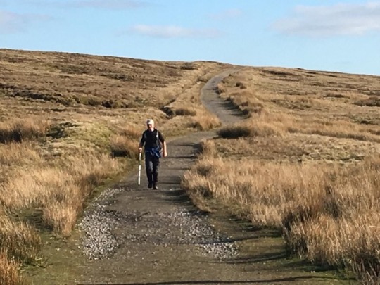
The Finish
Steve was there , having finished much earlier after camping on the ridge- good to see him

Al and Aussie James had finished yesterday after a 12 day crossing - as you can see they are younger!


A free half pint was expected and welcome. The certificate was a nice surprise!
It was good to chat to Steve and Kathy, and share a dram, and to catch up with Julie. The following day we headed home.

0 notes
Text
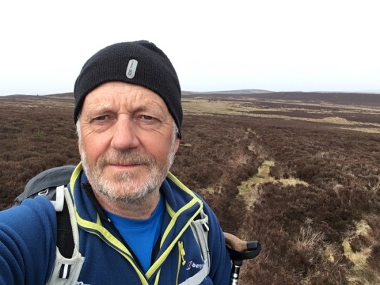
Day 16 - Byrness to Kirk Yetholm - 26 miles
I left Byrness at 6 am and climbed the steep hillside through mature pine-woods onto the open fell. It was a cool and misty morning, but it felt that the mist would burn off.


After about 5 miles I reached Chew Green. At this remote spot Dere Street, the Roman ‘A1’ crossed into Scotland. The modern A68 uses the head of Redesdale some 200 feet lower at Carter Bar. There are many earthworks of successive camps and forts lining the mossy green ancient road. I had dug through Dere Street 70 miles to the south , on the excavation of the Roman site at Piercebridge 70 miles to the south , where it crossed the Tees.

Chew Green fortlet.
Leaving Dere Street at the Scottish border, the PW heads NE along the border ridge. There are two refuge huts at 9 mile intervals- both clean and dry, but using them means carrying sleeping bags, stoves etc. I pressed on past Lamb Hill, Beefstand Hill, Mozie Law, and reached halfway at Windy Gyle.

Windy Gyle looking to The Cheviot
The long ridge continues another five meals to The Cheviot itself.
The going here is notoriously peaty

but not as bad as in the past. Slabs have again tamed the worst of it. The actual top of Cheviot was almost unreachable in the past due to deep , soft, peat, though I have been up Cheviot in winter when the bog was frozen.
A small dilemma here, to take in the extra 2.5 miles to revisit the summit itself. It isn’t actually on the route, and given the length of this stage and my sore stiff ankles, I pressed on.
At Auchope Cairn the route turns west to the finish, though not without a couple of significant re- ascents to The Schil and White Law. The dramatic gouged corrie of Hen Hole is on the right side. Its large crags are volcanic andesite. The Cheviots are quite different to the Pennines , which are mainly limestone, sandstone, gritstone sediments. Here the previously separate England and Scotland met in a tectonic collision about 400 million years ago and were welded together in volcanic violence, hard to believe in these gentle rounded eroded hills.

Hen Hole
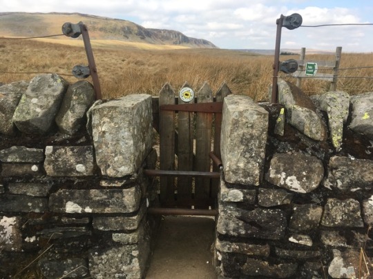
At last a sign which said ‘Kirk Yetholm’ - and it felt like proper evening now, looking west across the Scottish Borders.

There is one last small climb on tarmac , and there was Julie to meet me and walk me in. At the Border Hotel the route ends.

0 notes
Text
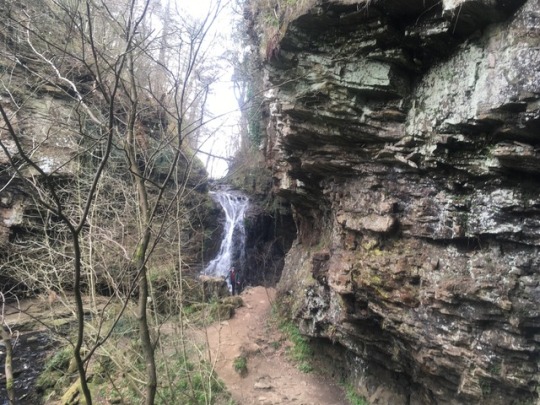
Day 15- Bellingham to Byrness - 16 miles
Bellingham is a proper little town in the valley of the North Tyne , with several pubs and shops. It might have been good for a rest day , which I was regretting not booking now. On the map this section looks rather dull. So I added the two mile walk up the pretty wooded valley of Hareshaw Burn to Hareshaw Linn waterfall.
To avoid the walk back to town I scrambled up the steep valley side and trespassed across half a mile of rough pasture to rejoin the PW. The easterly breeze was definitely warmer today after 10 cold days- and I found I enjoyed the bare spaces of mid Northumberland.
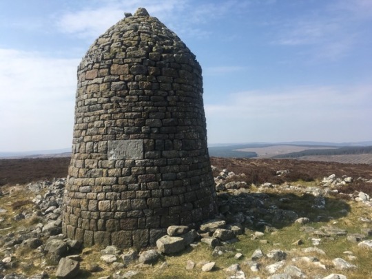
Monument on Padon Law
As I neared the end of the journey I looked up some information on the Pennine Way.
It was first suggested in the 1930s by activist and journalist Tom Stephenson , in an article ‘Wanted - A Long Green Way’. It was part of the outdoors movement rooted in socialism and the rights of people to access ancient rights of way shut off by grouse-shooting landowners. The first British National Park, the Peak District, was set up in 1951. Lobbying for the PW continued , but it was not until April 1965 that it finally opened.
Less popular in recent years , despite the taming of the worst peat, more walkers have done the PW since its 50th anniversary. Despite this I saw not a soul on the walk for two whole days on the Northumberland section. Steve was doing the PW having seen John Noakes and Shep do it on Blue Peter in the 1970s, and once he told me this I think that was also my first distant memory, and perhaps planted the seed in my brain?
The fastest crossing so far is by Mike Hartley- 2 days 17 hours 20 minutes in 1989. I find that astonishing...
In January 2019 Jasmin Paris won the Montane Spine Race - that is the whole PW in winter most of it in the dark and self supported, in 3 days 11 hours- 12 hours ahead of anyone else man or woman. I am speechless ..
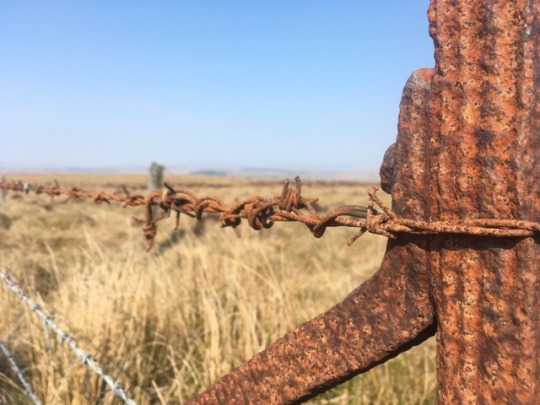
If you do the PW you will see a lot of these... my own crossing had been remarkably dry. I had not seen any rain since the first morning out of Edale more than 2 weeks ago .
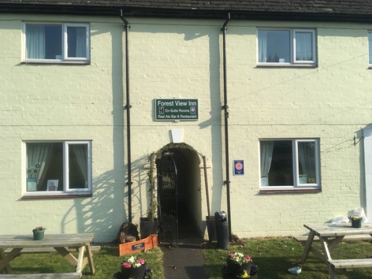
I was pleased to drop down through a pleasant open forest track, to Byrness in Redesdale, to stay in the quirky Forest View Inn. It was good to get messages from up the trail: Al and James had finished, and Steve was stopping for the night in the refuge hut at Auchope.
I was welcomed by Colin and Joyce , PW legends. I drank tea while Colin cleaned my boots, and told me stories of walkers before me, including Jasmin Paris who had rested briefly here before racing the last section.
There is nowhere to stop between here and the finish - so I planned to take on a mountain marathon the next day. I went to bed early with the alarm set for 5am , and despite feeling apprehensive was soon asleep.
0 notes
Text
Day 14 - Once Brewed to Bellingham -14 miles- North of the Wall
The next two days are a link to get to the Cheviots- arguably not even part of the Pennines- couldn’t I stop now? Everything - legs, feet, brain- feels a bit weary now.
Still, nobody made me do this!
The last few miles of the Wall took me past Peel Crag and Crag Lough. These steep north facing dolerite crags on the Whin Sill, were where I did my first proper rock climbing with Newcastle University Mountaineering Club in autumn 1977- looks proper scary now.


Sycamore Gap


Ellen and I did this section of the wall together last time I was here , much quicker and with a following wind, whilst Julie and the boys drove to pick us up.
The proper PW route turns north just past here, but I went a mile further to re-visit Housesteads fort and turned north instead through Knag gateway, a point where civilian traffic was allowed through the barrier in Roman times.

After that the route winds its way through rough moorland and long sections of pine plantation , including the boggiest bit yet..


The crossing of Warksburn brings a welcome break in the endless moor- good to see primroses and a slow worm . Deciduous trees that have been planted in tree tubes will soften this landscape, at least the ones that survive.

At Horneyburn Farm there is an informal tea-stop- where a notice invites you to help yourself to tea and Wagon-Wheels. The farming family were in and out and busy with the lambing, and pleased it was dry even if chilly - ‘ the wet’s much worse for them ‘ he said.
Behind the current farm house is its 15th century predecessor- a tumble down stone ruin , walls a metre thick, a fortified farmhouse or bastle. This was then the debatable land, not quite England or Scotland, where cattle and people were never safe from hostile raids.
Eventually the valley of the North Tyne , and the long approach to Bellingham ( Bellin-jam) finish the day.
0 notes
Text
Day 13 - Greenhead to Once Brewed- 8 miles
After three 20 mile days back-to-back, I was so pleased to have planned a shorter day, whilst the other three pushed on more than 20 miles again to Bellingham. My ankles hurt as I finished yesterday , so I had a leisurely start and some ibuprofen to start the day. Also - this is the Roman Wall.!
At Thirlwall stands the ruins of a medieval castle built entirely of re-used Roman stone.

The steep climb follows the Wall ditch and at the top the Wall itself appears for the first time, a few courses high.

At Great Chesters fort a Roman altar stands in the SE corner , and people have left coins as offerings on it.


I was surprised to see an Israeli coin , bearing a picture of the menorah amongst the coins. In AD 70 , the Romans brutally put down a Judean rebellion and sacked the temple in Jerusalem with great slaughter. The future Emperor Titus had a triumphal arch built in the forum at Rome, where the carved image of Roman soldiers carrying off the original sacred menorah can still be seen. Titus’ father Emperor Vespasian, had been in charge of the Second Legion during the invasion of a Britain, under the stuttering Emperor Claudius in AD 43. Eighty years later Emperor Hadrian ordered a halt to aggressive expansion across the Empire, and in the AD 120s ordered the building of a wall across northern Britain, saying ‘ thus far and no further’.

At the highest point on the wall at Whinshields Crags at 1100 feet looking east. I had brought Julie here on one of our first trips away together. Don’t say you weren’t warned!
I dropped down the short distance to the very new and swanky YHA hostel at Once Brewed , called The Sill. It’s great - but a bit like a Premier Inn in decor rather than a traditional hostel like Dufton , and I was back to being a billy-no-mates.
0 notes
Text
Day 12- Alston to Greenhead - 20 miles
The interesting old market town of Alston, presents a dilemma to the PW walker. The ‘proper’ route doesn’t get a good write-up , and there is now a good alternative, the fast level South Tyne Trail along the trackbed of the old Alston railway branch line. I knew Steve and Al and James were going to take it . ‘ oh I took the one less travelled by’ - and headed out on the PW - and it is ‘ ‘grassy and wanting wear’ - and a pleasant start to the day. Climbing the edge of Park Fell it meets the Roman road the Maiden Way and I followed it’s decayed zigzags out of the steep ravine of Gilderdale Burn to the Roman fort of Whitley Castle.


The fort has the most elaborate series of defensive ditches and sits on the valley side looking down to the South Tyne.
I did then take the railway route - which has a narrow gauge line built on it- but found the gravel hard on the feet and went back to the PW route when I could.

After Slaggyford Station- where the narrow-gauge line ends at a fine restored station- I followed the railway route again to Lambley as I wanted to see the fine viaduct across the river- it is a spectacular structure to build on a branch-line to small market town.

Rejoining the PW proper the route crosses Hartleyburn and then Blenkinsopp Common. This has to be the dampest dullest dreariest bit of the whole route so far. Wainwright hated it- I can see why. But it ends, and once across the busy A69 the first earthworks of Hadrian’s Wall , the Vallum , come into view. Following these across the golf course , empty on this cold windswept afternoon, I reached Greenhead.
Al and James were putting up tents by the bunkhouse and Steve was in the hotel bar. After two pints of ‘Ale Caesar’ whilst Tiger Woods won the masters on the TV, and a debrief of the day, I walked the last half mile to my eccentric choice of lodging (don’t ask..) - but it was warm and welcoming after another long day.

0 notes
Text
Day 11- Dufton to Garrigill ... no, Alston. 20 miles
But first I must tell of a small drama. Yesterday when leaving Middleton I had met an older man, Mike, a great PW aficionado , veteran of 12 (!) crossings , and in his mid 70s . He had eaten with Steve, my new friend , at the Tan Hill , who had passed on this info while we walked together. I stopped to buy a sandwich and snacks (veg samosas and onion bhajis- proper hill food!) at the Co-op- Mike pressed on.
I passed him at High Force as he was moving (only a little) slower- and as he is stone deaf he insisted I didn’t wait.
So when I got to the excellent Stag Inn in Dufton it was great to see Steve sitting there having a beer.... but worrying to hear that he had seen Mike at the steep scrambly section by Cauldron Snout, who told him he was a bit tired and had no food! He knew it was a 21 mile stage as he had told me , so not carrying food seemed bonkers.
So it was with great relief , and beers all round, when Mike arrived at half past 8 as it was getting dark. Once Al (from Leeds ) and his friend James ( from Oz) , doing 25 mile yomps on the PW and camping out, joined us, it was a proper party. In fact reminiscent of the Kings Head and Bell , except with beer!

Cross Fell from Dufton YHA
I said goodbye to old Mike, heading home (hope he made it) and new friend Steve , aiming for Alston rather than my intended stop in Garrigill. I was pleased my legs felt good on the initial gentle climb above Dufton, then the steeper ground on the open fell to Knock Fell. From here over Great Dun Fell, with its prominent radome, and Little Dun Fell , the hills feel Scottish in scale and remoteness. The sparse grass and peat feel like parts of the Cairngorms.
The next climb is Cross Fell, highest point in the Penninea, and high point of the walk. The Lake District fells were not far away to the south east, Blencathra and Helvellyn prominent


The stupa-like cairn on Cross Fell

There were some decent patches of snow remaining on the northern as I dropped down to Greg’s Hut , one of the few bothies in England and at over 2000feet in altitude. My name is in the bothy book on 13th April 2019 if you are passing..

There is an old miners road from here, which has been recently ‘upgraded’ with a new rammed sandstone surface, I think so that grouse shooters can get up the hill. It is hard on the eyes and harder on the feet, and the six mile descent seems endless. So I was pleased to finally get down to the pretty village of Garrigill in the upper South Tyne Valley. Joe and I had stopped in at the village pub on day 2 of our C2C bike ride, and it is a nice traditional pub with open fires and a stone flagged floor. But it had closed down.... so nothing for it but to walk the extra 4 miles to Alston.
In fact the grassy path down the S Tyne is a pleasure, even more so on arriving at the YHA on the edge of town it had a free bed. So a massive phew!

Steve was in the adjacent pub, which was nice, and we were joined by Aussie James, also staying at the hostel. We talked of other journeys, and I mentioned I had climbed the Munros, yes even the Inaccessible Pinnacle, albeit age 21. James told us that last year he had done the SW coast path from Landsend to Bristol, gone onto the Offas Dike path, up through the Lakes, the borders, the West Highland Way, and then to John o’Groats. 1100 miles on foot. That was game set and match in long distance walking Top Trumps!
0 notes
Text
Day 10 - Middleton in Teesdale to Dufton - 21 miles
This was to be the biggest day so far. I had considered splitting it into two 9 and 12 mile days- but there is a balance between over- and under-doing it.. so here goes. I was well- (well over-) fed at Forresters Bistro the night before- an unlikely French themed bistro

Smoked cauliflower Tarte au Tatin (starter!)

Once again it was lovely , and this part of the Tees is lovely too. Low Force then High Force - then Force Garth quarry with it’s giant gloppeter-gloppeter machine making roadstone from the basalt of the whin sill.


The Tees is the river of my birth in Stockton-on-Tees, and also where I grew up, in Darlington , so this was a homecoming .
Julie , me and the children , along with my dad, had once walked this bit of the Tees at Easter. It had started to snow and I was worried about baby Harry in his sling actually freezing , and had him tucked inside my coat.... we were glad to find a warm refuge in the Strathmore Arms in Holwick.
I was looking out for the famous spring gentian , only found in Britain in upper Teesdale ,but it was still too early though I found one about to flower.

**ethics warning** photo taken 10-5-2018 in same spot
Next Cauldron Snout

then the long hard trudge up a newly made track over the top. The going gets easier as once more the way is grassy on the gentle drop to Maize Beck. Then suddenly the ground drops away in the dramatic bite of High Cup Nick - one of the sights of the Northern Pennines


then it’s only the 4 miles of stony track , jarring on tired feet, to get to the pretty Cumbrian village of Dufton.
My first wild camp was in this same country. I had met Paul Fraser at 6th Form College - and he had introduced me to walking in the Lakes . He could borrow a tent as he was a Venture Scout- and we got a lift with my mum to Dufton and set off up High Cup Nick and off to the wild country above Cow Green Reservoir. We camped in a peat grough and spent a damp night in wild weather and snow - before bailing out the next day down the Pennine Way to Holwick where .our second night was in the then bunkhouse behind the Strathmore Arms. A small but real adventure - which led on to backpacking trips to the Lakes and then Scotland . It was with Paul (who sadly died at 40 of a brain tumour) that I climbed my first Munros- and I wouldn’t be on this trip if not for him- so thanks old friend for 40 years of hill-going, and RIP.
0 notes
Text
Day 9 - Tan Hill to Middleton in Teesdale- 17 miles
Julie left at 7 am missing both breakfast , and hopefully the worst of the traffic . It was great to have her company for 2 days.
After the very slow service of the night before , so slow we’d been given a free pint - breakfast went better. The PW heads NE across the famously boggy Sleighthome Moor - but as it had got down to -5 overnight the frozen bog made generally good going.
I caught up big pack man , who turned out to be Steve from Kent, and we chatted as we walked. He was gradually sending stuff home he didn’t need but still carrying 20kg- ouch..

As we crossed the beck the air was loud with the reedy cries of lapwing, honking greylags circled, oystercatcher piped across the stream and there was the ever-present bubbling cry of the curlew. I think I also saw a snipe.
We crossed God’s Bridge- a natural limestone slab under which the River Greta has tunnelled a course ..

..and rapidly crossed the old Stainmore Pass railway then the Roman road from Scotch Corner to Penrith - now the A66 . In February 1947 a train was stuck in a snowdrift on this line for two months , and even jet engines mounted on bogeys failed to free it.. those were the days. What a great cycle way it would make?

This graffiti has a mixed message ( it says ‘Suckers’ underneath!

Steve stopped for a brew- I carried on up and down over the side valleys of Baldersdale and Lunedale. At Low Birk Hatt ‘ Hannah’s Meadow’ commemorates Hannah Hauxwell made famous in a 1970s TV documentary ‘Too Long a Winter’ about her harsh life in the high Pennines.


After a last climb Middleton in Teesdale came into view and a gentle grassy descent took me into town.
0 notes
Text
Day 8 - Hawes to Tan Hill Inn - 16 miles
It was a fresh cold morning , crossing the wide valley floor and over the River Ure *(Wensleydale doesnt have a River Wensley, and was often known as Uredale or Yoredale in the past..)
Julie parked at Hardraw and joined me on the broad stony track , the first big climb of the day. A shepherd on a quad bike was feeding concentrate to a large flock who galloped down to meet him as he shouted to them.


There were 2 other Pennine Way walkers at the summit shelter on Great Shunner Fell, at 2349 feet , the highest point so far in the walk. One had left Edale on the same day as Chris and I, and we had met him on Jacob’s Ladder , the first climb into Kinder Scout, but not seen him since. The other man carried a heavy pack and was camping out- chapeau!
Julie returned to Hardraw, and I headed down to the top end of Swaledale at Thwaite in what was now a lovely sunny day. The views opened up of the place my family had been coming to since the 1930s. My parents rented a cottage in Healaugh near Reeth for 10s a week in the 1960s and we came up for weekends, and later holidays and family get-togethers including mum’s 80th and dad’s 90th.
More sadly last year we had scattered dad’s ashes above the Old Gang mine , and nearby are my mother’s ashes, and those of my older brother Paul.

Upper Swaledale


The walk along the side of Kisdon Hill is well known but not busy -the primroses were coming through last years bracken

I met Julie again at the farm cafe in Keld- then down across the Swale and the last 5 miles up to the very welcome sight of the Tan Hill Inn - lonely on the moor top.

0 notes
Text
Rest day - Hawes in Wensleydale


Julie drove up and joined me in Hawes and we spent a nice day wandering round - including a cheese-themed lunch at the creamery. In the afternoon we went to the Dales Museum and watched prints being taken from original woodcuts made by Marie Hartley to illustrate books about the Dales in the 1930s - beautiful craftsmanship.

Back on the trail tomorrow- heading for Tan Hill.
103 miles done
274000 steps counted!
It has often been solitary - but never lonely. A big thanks to anyone who has been in touch, responded to a post , or shared some chat. And to Julie for making the journey north for just a few days.
0 notes
Text
Day 7- Horton to Hawes - 14 miles
This was to be the last day of 7 in a row and looked lovely from inside , but there was a cold north-easterly wind blowing dead in my face all day.
A gentle climb out of the valley put me in hill cloud - none of the promised views of Ribblehead Viaduct or anything else once past Ling Gill Bridge


Pennine Way looking north 🙂

Pennine Way looking south 😟
Still - 100 miles were done and Hawes in Wensleydale hove into view- and a welcome rest day .

0 notes
Text
Day 6- Malham to Horton-in-Ribblesdale - 14 miles
At last the Dales.
My legs felt stronger , and the pack lighter, as I left the hostel , walked through the pretty village, and climbed the steep steps up the side of Malham Cove


There is a peregrine nest on the cliff- and though I didn’t see them I heard their loud mewing.
A dry valley leads to Malham Tarn, then a lovely meander on a great path takes you over the shoulder of Fountains Fell. The minor summit is a few hundred yards off route but was worth the detour as the distant haze in what had turned into a sunny day . Golden plover called their plaintive whistle .


After dropping 800 feet the steep climb of Pen y Ghent , one of the ‘Three peaks of Yorkshire’ begins. Suddenly the path was busy with school groups and families, but it was a lovely Sunday in the Dales.


Pen y Ghent- 2277 feet and highest point so far.
There are large built steps off the back of the hill as this path is so busy. A good bridleway drops down to Horton , my lodgings , and a pub showing the end of Watford v Wolves in the FA cup.
I also met some Three Peaks walkers, and for the first time in 5 days someone else doing the Pennine Way. She was Dutch, not young, had set off 2 days later than me, and was camping but only carrying 6kg ?! I felt a bit soft!
0 notes
Text
Day 5 - Ickornshaw to Malham- 17 miles

The twin highlights of my stay in Cowling , just off route down the busy A road, were a busy pub with beer at 3 pounds a pint , but no food, and Harlequin bistro which did a very nice fish pie and was run by a friendly young couple. They immediately guessed I was walking the Pennine Way.
Leaving the Air BnB with no breakfast and no sign of the owners was a bit gloomy, so breakfast was some nuts and raisins and the last of yesterday’s cheese sandwich in the pretty village of Lothersdale.

This is described as a ‘transition’ stage- and it was downhill to the relative lowlands at Thornton-in-Craven and Gargrave , at only 300 feet above sea level.

The Leeds Liverpool canal is pretty and for the first time in 5 days there was actually a cafe on the route.

The last 6 miles to Malham was a drag. Feet tired legs tired knees achey backpack too heavy ..
Dippers and pied wagtails in the infant River Aire , and the warm sunshine, were some compensation and the last three miles are actually lovely.
This was my first night in a Youth Hostel- nice to see young families about with kids on bikes and kicking footballs. My room-mate has done the PW with his father years before and had loved it.
Malham was very busy on a sunny Saturday - and I found out I had booked to eat in the hostel too. It’s called ‘supper club’ and I expected to chat to walkers , cavers , travellers..... turns out I was on my own again! It can only get better
0 notes
Text
Day 4 - Calder Valley to Ickornshaw - 15 miles
Thanks to Sandra and Jules for their great hospitality - and for NOT doing a cooked breakfast - I think we both felt the better for it.
The view back to Stoodley Pike was lovely as we left for a leisurely start.


Chris headed to Hebden Bridge and the train home at the bottom of the hill, a big thanks to him for making the first three days enjoyable. The miles went quicker in company, as I was about to find out.
I headed north and up the steep paved way up the valley side , winding it’s way through houses and back yards.


Boot Hill?

Crossing Jack Bridge the route heads on to the open moor. There were curlews calling in the bright morning.
As I headed onto Heptonstall Moor a man walking his beautiful collie chatted for a few minutes. He said there were more birds in the past, and lamented the lack of hen harriers. ‘Grouse moors..’ he said ..

Passing Walshaw Dean reservoirs there were some greylag geese calling and splashing close in-shore, a nice change from the ubiquitous Canada geese.

Crossing the gentle col at Withins Heights , the ruined farm of Top Withins came into view. Famous as the supposed sight of Wuthering Heights in Emily Bronte’s novel , a plaque on the wall suggests it perhaps was only inspiration. It was a bleak place to earn a living .


The last seven miles were starting to drag , and I was glad to get to Ickornshaw and stay in my first ever Air BnB .

A do-er upper?
0 notes
Text
oops - this bit is a duplicate but I can’t remove it ! 😳
Day 3 -Standedge to Calder Valley- 15 miles
A mile back up the hill felt like quite a long way with tired legs and mysteriously heavy packs. Having decided on a lighter breakfast, it turned out our host had already cooked two massive full English breakfasts so Chris and I had gained weight too….
It was cold and blustery on the top and I took us off on the Pennine Bridleway and we had to retrace our steps by 200 metres-my first navigation error.
After 5 miles we came to the footbridge over the M62


1 note
·
View note
Text
Day 3 -Standedge to Calder Valley- 15 miles
A mile back up the hill felt like quite a long way with tired legs and mysteriously heavy packs. Having decided on a lighter breakfast, it turned out our host had already cooked two massive full English breakfasts so Chris and I had gained weight too....
It was cold and blustery on the top and I took us off on the Pennine Bridleway and we had to retrace our steps by 200 metres-my first navigation error.
After 5 miles we came to the footbridge over the M62

Do-er upper?
We came to Blackstone Edge with its paved Roman (?) road

and then into an ever stronger , colder wind joined the service road past the reservoirs on the moor top.
At an old quarry a Simon Armitage verse has been carved into the rock

We stopped and picked at what must be the biggest packed lunch ever assembled, but it was too cold to linger

The final boulevard above the Calder Valley led to Stoodley Pike- such a familiar landmark , before the descent to the Rochdale Canal . Then the short climb in dampening rain to the very welcome sight of Jules and Sandra’s house- so considerate of them to happen to live on the Pennine Way !


1 note
·
View note