
Hello, my name is Quentin Chaillet-Chamayou, I am a master student in Geography at the KU Leuven. My background knowledge lies in urban planning, optic fiber deployment project and international cooperation. I also form myself towards GIS modelisation and programming technologies. This Tumblr page highlights the main projects I've done during my studies.
Don't wanna be here? Send us removal request.
Statistics
We looked inside some of the posts by quentinch-projects-blog and here's what we found interesting.
Average Info
Notes Per Post
0
Likes Per Post
0
Reblog Per Post
0
Reply Per Post
0
Time Between Posts
9 months
Number of Posts By Type
Text
5
Photo
3
Last Seen Tumblr Blogs


Fun Fact
70% of Tumblr users say the Dashboard is their favorite place to spend time online.
Text
ASSESSING THE URBAN QUALITY OF LIFE TROUGH GEO-DATA: The 15-minute city product.

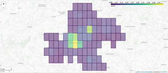

During the last year of my master's degree in Leuven, I did a 40-day internship within the GeoSolutions’ Data Insight team. GeoSolutions is a company based in Edegem (Belgium) with expertise in Geo-ICT, which helps clients make informed decisions with the correct information. They believe in the "power of location" as a way to provide open-source data solutions to both private and public organisations.
The core of my mission concerned the result of a mapping tool from open-source data assessing the urban quality of life throughout the concept of the ‘15-min city’. The model, made for cities in Flanders, aims to answer how far everyone can go from their home by a 15-minute walk and what facilities they find. The internship aimed to develop a tool that uses geo-localized data to assess cities' urban quality of life with the 15-min city concept. The device aims to answer the question, "Where is the best location to live regarding the 15-minute city concept?" The purpose was to respond to the value of data analysis in providing tools and support for practitioners and decision-making bodies towards the leverage of urban quality of life.
0 notes
Text
Sub-pixel classification methods in Advanced Earth observation techniques
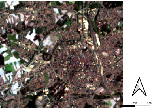

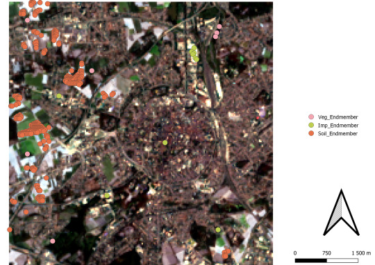
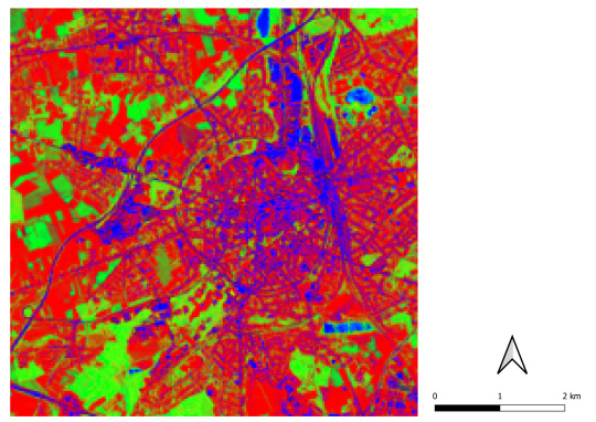


This project is part of an exercice from the course Advanced Earth observation techniques attended from October until December 2022 in Brussels at VUB University. The course provides me with skills and experience in remote sensing techniques, methods, analysis and visualisation.
The classification might be inconvenient to produce in medium and low-spatial resolution images. Some areas have many land cover types more minor than the pixel’s size, engendering what can be named “mixed” pixels like urban and rural areas. However, image acquisition from the multispectral sensor in lower and medium resolution is the easiest, providing good cycle repeat time. Hence, such satellite image is essential for land cover, land use mapping, and visual detection change. The question remains: Which methodology can be applied to develop a classification that can deal with “mixed” pixels? This report aims to test several methods to assess sub-pixel classification efficiency and accuracy. It is expected that some plans will offer better results than others. The performances will also be due to the methodology and input type. Some methods will be better but more complex to implement. Most forms of sub-pixel classification will depend on the purpose of the sort and the type of land cover searched.
The Study focuses on medium-resolution images (Landsat 8) and high-resolution (Apex) in the region of Leuven and Brussels to test several Sub-pixel classification methods.
0 notes
Text
KU Leuven - Modelling Land use change

From February to May 2022, I attended the Modelling Land Use/Cover Changes course at KU Leuven. In collaboration with students from the master’s degree sustainable development, we cooperated in pairs into modelling exercises. Each exercise consists of the development of models explaining and predicting major events of land Use change around the world. The models were made through python scripts in Spyder.
Modelling is important to predict future changes and try to mitigate them. Furthermore, the pair team was an enlightening experience because of the multicultural aspects of the students. In total three exercise has been made.
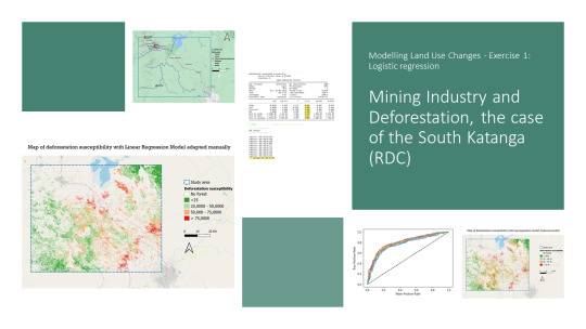
First exercise concerned the main drivers of tropical forest’s deforestation through a linear regression model. This exercise has been done in collaboration with Enrico ROETS a sustainable development master student from South Africa. We decided to focus on the region of South Katanga in RDC because this region is impacted by mining industry.
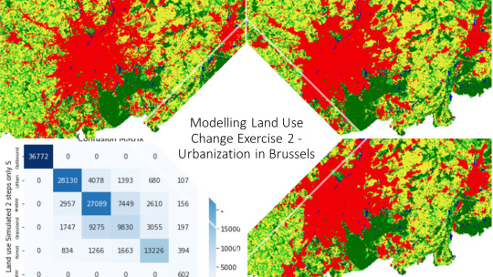
The second one consisted of a cellular automaton model to predict urbanization effects in Belgium. Cellular Automaton use the raster data by affecting each pixel to a land use category (Urban, Arable Land, Water, Grassland, Forest) and by applying transition rules to predict the future land use of each pixel in the future. This exercise has been made in collaboration with Lennert ESKENS a sustainable development master student from Belgium and Leo Mundt, an exchange student (Erasmus) from Germany.
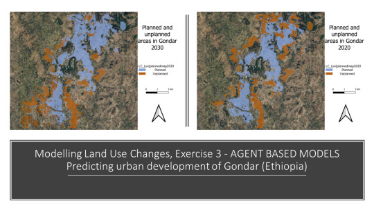
The last exercise, agent-based model, aimed to predict urban sprawl towards the utility maximisation of inhabitants. The utility depends on their social (poor and rich residents) and family status, both determine their area of interest to settle in the city. The difference between planned and unplanned is determined by the interests of the inhabitants and planners (municipality). The study area was the city of Gondor in Ethiopia, the model predicted the evolution between the plan and unplanned areas regarding the population evolution in 2030.
0 notes
Text
KU Leuven - Introduction to geoprocessing - Urban Heat Island in the Greater London
From September to December 2021, I had the opportunity to attend Introduction to geoprocessing. The course aimed to provide a good introduction to Python programming language. The final exercise concerned the use of raster data to produce charts and maps about the thematic of the Urban heat Island concept.
Urban Heat Island is a climatic phenomenon happening in major cities where the massive urbanization provokes rise of temperatures. The objective was to translate the raster Data provide by Copernicus and display them in several ways to explain the concept. I chose the greater London, and the results shows a major increase in the temperature in the main centre.
Scholars explain the effect through several explanation. Buildings can absorb the heat regarding their materials, the lack of vegetation due to the need for housing, and the traffic who produce greenhouse gas enhancing the warming of the air.

youtube
0 notes
Text
KU Leuven - IDV Project - Poverty Among the city
From September to December 2021, I attended a course from KU Leuven named Interactive Data and Visualization. The purpose was to comprehend the role of Data interaction and visualisation to communicate specific ideas and concepts.
It was furthermore a perfect opportunity to form myself into web programming language. Most of the project has been done in HTML, JavaScript, and CSS. The final project’s task was to pick a topic and describe it only with charts on maps.
I decided to focus on poverty across the city of Paris. The French capital might be one of the wealthiest cities in the world, it remains nonetheless that social inequalities are the most important of Europe. I tried to create an interactive way to showcase data and claimed the main social disparities inside the city of Paris. The main approaches lie on the good interaction of the users with the charts and maps to understand the main ideas I was advocating.


youtube
0 notes
Photo


REVITALIZING AND CONECTING GREEN AREAS IN ANNEMASSE
September 2016 - January 2017
This project was realized while my first year of master degree in Grenoble. It was with students from the master International Cooperation Urban Planning (ICUP) also in Grenoble and erasmus students.
Our aim was to Opening up and connect the Brouaz district through a revitalization and a requalification of areas. The Brouaz district is a brownfield located in the South West part of the city. This project was realize in collaboration with: RECOULES AUbe (Grenoble) LATTANZIO Clara (Grenoble) NOUSSAIR Kamilia (French from the master ICUP) PŁATEK Iga (Polish erasmus student from Krakow) WOJCIECHOWSKA Alicja (Polish erasmus student from Krakow)
0 notes
Photo


RENEWING / REVITALIZING : CREATING LIVEABLE CITIES
3rd International workshop OIKONET, June 2016
OIKONET is an european network of severals archtitecture and city planning schools. They organised for one week a workshop in Belgrade (Serbia).
The main goal was to revitalized a post-industry district, Kosancicev Venac. Our group proposed an urban regenerationt with the “Art” as a catalyst. Then we propose a big strategy (projects, public participation) involving severals actors link to cultural activties and the local habitants. The meaning of our project was to bring the “creative class” in the district, then they will develop a new lifestyle who will bring economy and social atractivity.
It was a really good opportunity to initiate myself into international cooperation. A great human experience which allowed me to acquire new knowledge and open myself to the different way of design the city.
0 notes
Photo


SMART CITIES FOR KNOWLEDGE-BASED SOCIETIES IN CEE:
Research and scenario development of the south part of Petrzalka district in the city of Bratislava.
Project realize in my eramus intership at the Slovenska Technika Universita v Bratslave. The project was in collaboration with Magdalena Vasileska (architect Phd, Nis, Serbia) and Margareta Banaszewska (engineer, Wroclaw, Poland)
0 notes