
raychelsnr
Raychel Sanner
Creator. Influencer. Emmy Award Winner.
10758 posts
Don't wanna be here? Send us removal request.
Last Seen Blogs

coloradofishingexpeditions
Fishing Guide


mikespice97
Hi! I’m Mike

thehiddenbaroness
The Hidden Baroness

naitosutan
Everyone’s Waiting For You With Big Smiles
Text
youtube
Large Tornado documented by Erin Moe and Tim Slane during yesterday's (4/26) tornado outbreak
5 notes
·
View notes
Text
youtube
This intense tornado was captured by Titan Partners Tim and Lauren Baca near Lincoln, NE - 4/26
4 notes
·
View notes
Link
It's never a bad time to look at photos of storms and talk about what they were doing. Here's a quick lesson. Let us know if you liked this, we'll try to do more in the coming months!
GEAR I USE
Panasonic G9: https://amzn.to/3CxdWLo Panasonic 12-35mm: https://amzn.to/3M4tOIl Panasonic 12-60mm: https://amzn.to/3e3pWuC Panasonic X1500: https://amzn.to/3Cx0NCc GoPro: https://amzn.to/3e1FL5h Insta 360 One X2: https://amzn.to/3SCPxcS Pelican Case: https://amzn.to/3SL06ue
CONNECT WITH US
Subscribe to our newsletter: https://www.tornadotitans.com/our-newsletter/ Website: https://www.tornadotitans.com Instagram: https://www.instagram.com/tornadotitans Facebook: https://www.facebook.com/tornadotitans
1 note
·
View note
Link
The skies of storm season from across the South and Southwest! #weather #science
2 notes
·
View notes
Link
SUBSCRIBE TO OUR FREE NEWSLETTER: https://www.tornadotitans.com/ VISIT OUR WEB SITE FOR THE LATEST WEATHER AND STORM CHASING NEWS: https://www.tornadotitans.com
GEAR I USE
Panasonic GH6: https://amzn.to/47Q477S Panasonic G9: https://amzn.to/3CxdWLo Panasonic 12-35mm: https://amzn.to/3M4tOIl Panasonic 12-60mm: https://amzn.to/3e3pWuC Panasonic 7-14mm: https://amzn.to/3SzZ2fo Panasonic X1500: https://amzn.to/3Cx0NCc GoPro: https://amzn.to/3e1FL5h Insta 360 One X2: https://amzn.to/3SCPxcS Insta 360 One X3: https://amzn.to/3udvAT5 Insta 360 One RS 1-inch: https://amzn.to/3SvrT4t SanDisk SD Cards: https://amzn.to/3UayfYm Pelican Case: https://amzn.to/3SL06ue
You should follow us on our other social media channels as well! And if you don't, we'll has a sad.
Instagram: https://www.instagram.com/tornadotitans Facebook: https://www.facebook.com/tornadotitans TikTok: https://www.tiktok.com/@tornadotitans
0 notes
Text
youtube
Let's Diagram Some Severe Storms and Talk Storm Structure!
1 note
·
View note
Text
youtube
The skies of storm season from across the South and Southwest! #weather #science
3 notes
·
View notes
Photo
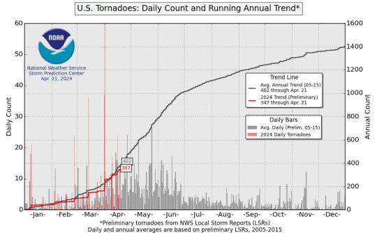
If you live on the Plains, aka the ‘traditional’ Tornado Alley, you would feel that this year is anything but average with few tornadoes thus far. But if you are a resident of the Midwest, particularly from Illinois to Ohio, you definitely feel like you are in the midst of a historically active season.
Thanks to that activity over the Midwest, we are running very close to average in terms of tornado count across the whole country. Given the pattern ahead, it is likely we stick at least to near average with more tornadoes over the Plains likely ahead — but an above-average May would mean we are likely to end the year pretty active overall.
11 notes
·
View notes
Text
youtube
EPIC supercell near Leoti, Kansas! This storm formed in a small pocket of enhanced wind shear.
4 notes
·
View notes
Link
The Plains have been pretty slow in terms of actual tornado production so far this Spring -- but that's neither unexpected or unusual. And what is also not unexpected: it's about to get a lot busier.
SUBSCRIBE TO OUR FREE NEWSLETTER: https://www.tornadotitans.com/ VISIT OUR WEB SITE FOR THE LATEST WEATHER AND STORM CHASING NEWS: https://www.tornadotitans.com
There is consensus agreement amongst weather models, from ensembles to climate models, etc., on big-picture details of how the pattern is set to evolve in the coming weeks. This is highly unusual and somewhat alarming, given that they're all agreeing on a traditionally favorable pattern for severe weather in the Central U.S.
Let's break it down.
GEAR I USE
Panasonic GH6: https://amzn.to/47Q477S Panasonic G9: https://amzn.to/3CxdWLo Panasonic 12-35mm: https://amzn.to/3M4tOIl Panasonic 12-60mm: https://amzn.to/3e3pWuC Panasonic 7-14mm: https://amzn.to/3SzZ2fo Panasonic X1500: https://amzn.to/3Cx0NCc GoPro: https://amzn.to/3e1FL5h Insta 360 One X2: https://amzn.to/3SCPxcS Insta 360 One X3: https://amzn.to/3udvAT5 Insta 360 One RS 1-inch: https://amzn.to/3SvrT4t SanDisk SD Cards: https://amzn.to/3UayfYm Pelican Case: https://amzn.to/3SL06ue
You should follow us on our other social media channels as well! And if you don't, we'll has a sad.
Instagram: https://www.instagram.com/tornadotitans Facebook: https://www.facebook.com/tornadotitans TikTok: https://www.tiktok.com/@tornadotitans
4 notes
·
View notes
Link
You probably don’t need to hear this, but the details […]
0 notes
Link
It looks like our string of severe weather threats may […]
0 notes
Text
youtube
Documenting extreme weather from the front lines can result in very dramatic photographs...
3 notes
·
View notes
Photo

Today is a classic marginal, very low-end day for severe storms across the region. The main story will be the noisy storms and heavy rain across much of Northern Texas. In true washout fashion, it’s likely that any outdoor activities need to be put on hold.
Further south, a few storms could produce some large hail and there is a non-zero tornado risk. While wind shear and instability aren’t very high, a storm could acquire some rotation briefly.
This is a great day for most storm chasers to rest, and wait out the prime time stuff late next week.
0 notes
Photo

Models are consistent with a solution that implies sustained W and SW flow over a moist airmass in Tornado Alley starting late next week. This is a classic setup for multiple rounds of severe thunderstorms over several days.
It’s hard to pin down too many specifics right now, as there is a decent model spread among members. However, it does seem likely that we will see multiple successive severe weather risks of varying degrees starting Wednesday or Thursday of next week.
Right now, the most pressing days of the next week look to be Friday through Sunday. However, models disagree about the degree and speed of storm systems being ejected over the warm/moist airmass. Timing is everything, as storm chasers should know all too well after events earlier this month. Still, with the increasing sun angles and the better moisture, the atmosphere will likely not find ways to go bust through this whole setup like in prior systems.
We’ll be keeping a close eye on this. Storm chase mode is already activated, and plans are being made.
4 notes
·
View notes
Text
youtube
This Isn't Groundbreaking: But The Pattern Is About to Get Busy
1 note
·
View note