
Don't wanna be here? Send us removal request.
Statistics
We looked inside some of the posts by sathiyarajm and here's what we found interesting.
Average Info
Notes Per Post
1
Likes Per Post
1
Reblog Per Post
0
Reply Per Post
0
Number of Posts By Type
Text
1
Last Seen Tumblr Blogs


Fun Fact
Tumblr has 4 main sources of revenue.
Text
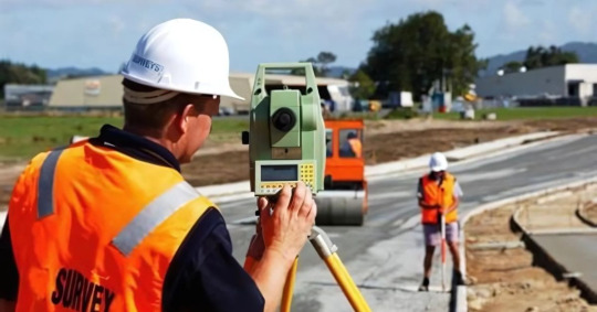
Route Surveys: The Silent Force Behind Every Safe and Smooth Road

In the following sections, I will present the basic definition of route surveys and their importance, and I will also shed some light on some of the general methods of route surveying that help develop safe, cost-effective, and long-lasting roads.
What Exactly Are Route Surveys?
Think of route surveys as a detailed “map check” for new roads, railways, or pipelines. Before anything is built, experts come out to study the land carefully. They check out everything from hills and valleys to soil quality and existing buildings. This helps them understand the land’s natural challenges and find the best way forward.
Simply put, route surveys answer important questions like:
Where should the road go?
What obstacles need to be avoided or planned for?
How can we save money and stay safe while building?
Without this step, construction can run into big problems later on.
Why Are Route Surveys So Important for Roads?
Imagine building a road without really knowing the land—it could mean steep hills, weak ground, or protected wildlife areas that cause huge delays or extra costs. Here’s why route surveys matter:
1. Getting It Right From the Start
Route surveys provide precise information so engineers can design a road that fits perfectly with the land.
2. Saving Money
Finding problems early means avoiding expensive surprises during construction.
3. Keeping Everyone Safe
Choosing the right route lowers the risk of accidents and structural issues.
4. Following the Rules
Governments often require detailed route surveys to approve new roads and make sure the environment is protected.
Common Route Surveying Techniques
Modern surveying relies on a mix of traditional skills and advanced tools. Here’s a quick comparison of commonly used route surveying techniques:
Technique
Description
Best Suited For
Topographic Surveying
Captures the elevation and contour of land surfaces.
Planning layout and grading work.
GPS/GNSS
Satellite-based positioning systems for accurate location tracking.
Open areas and large-scale surveys.
Total Stations
Electronic instruments for precise distance and angle measurement.
High-detail site measurements.
LiDAR Scanning
Uses laser pulses to generate 3D models of terrain and objects.
Forested or rough terrain.
Drone Surveys
Aerial surveys using drones for quick data capture over large areas.
Large, hard-to-access construction sites.
Technique Description Best Used For
Topographic Surveying Maps land features like slopes and elevations. General layout and design planning.
GPS/GNSS Uses satellites to find precise coordinates. Accurate point marking and navigation.
Total Station Combines angle and distance measurement tools. Highly accurate site surveys.
LiDAR Scanning Uses lasers to scan terrain from the air or ground. Dense vegetation or uneven land.
Drone Surveys Captures aerial photos and data quickly and safely. Large or hard-to-reach areas.
These route surveying techniques are often combined to produce the most reliable data for planning roads and other infrastructure.
How Does a Route Survey Actually Work?
Here’s what usually happens:
1.Planning Ahead – Surveyors start by looking at maps and previous info to prepare.
2.Out in the Field – They visit the site, take measurements, and check the ground.
3.Crunching the Numbers – The data is processed with software to figure out the best path.
4.Sharing Results – Surveyors create reports that help engineers design the road.
Using the right route surveying techniques at each stage is key to making the survey accurate and useful.
Real-Life Success Stories
Take the example of a highway planned through hilly land. Thanks to a detailed route survey, engineers spotted unstable soil and landslide risks early on. They changed the route slightly to avoid these trouble spots, saving lots of money and making the road safer for everyone.
Similarly, pipelines that cross forests or rivers depend heavily on route surveys and modern route surveying techniques to protect wildlife and minimize environmental damage.
What are the Challenges Surveyors Face?
Surveying is not always easy. especially in India’s varied landscapes. Here’s a breakdown of some common challenges:
Challenge
Explanation
Difficult Terrain
Mountainous regions, forests, or marshes can be hard to access and survey.
Weather Conditions
Heavy rain, extreme heat, or fog can delay survey activities.
Remote Locations
Sites far from towns may lack roads, electricity, or communication signals.
Environmental Regulations
Surveyors must work around wildlife zones, water bodies, or heritage sites.
Land Ownership Disputes
Unclear land titles or encroachments can delay or block survey work.
Challenge Description
Rough Terrain Mountains, forests, or rivers can limit equipment access.
Weather Conditions Rain, extreme heat, or fog can delay or disrupt survey activities.
Remote Locations Some areas are difficult to reach, increasing time and cost.
Environmental Laws Surveyors must work around protected areas, wildlife, and forest zones.
Technology has certainly played a big role in tackling many of these challenges, but we still need human expertise to make sound decisions in real-world situations.
How to Choose the Right Route Surveying Team
Picking the right survey team is key. Look for:
Experience with projects like yours
Use of modern technology and methods
Clear, detailed reports you can trust
Good reviews or recommendations
A great surveying partner who understands route surveys and applies the latest route surveying techniques will make your whole project smoother and less stressful.
Route surveys may not be the prickle in the tongue during road building, yet they remain a paramount procedure. They help ensure roads planned well, made safely, and for the long term.
Any construction project should warrant you working with professionals who can competently apply the route surveying techniques. It will be an investment for you to sleep well and come out an obvious success.
1 note
·
View note