#3d Laser Scan To Cad
Explore tagged Tumblr posts
Visit Tumblr Blog
Explore Tumblr blogs with no restrictions, modern design and the best experience.
Last Seen Tumblr Blogs


Fun Fact
Tumblr is used by 21% of adults online aged 18-29 years.
Text
Transforming Reality into Precision: The Power of 3D Laser Scan to CAD
In the world of design, construction, and engineering, accuracy is paramount. Whether you're working on a large-scale infrastructure project or a complex architectural renovation, having precise measurements and data is essential to success. One of the most revolutionary technologies to impact these fields is 3D laser scanning. When combined with Computer-Aided Design (CAD) software, it allows for the creation of highly detailed, accurate digital models of real-world environments. This process, known as "3d Laser Scan To Cad," has transformed industries by improving efficiency, reducing errors, and enhancing collaboration.
What is 3D Laser Scanning?
3D laser scanning is a process that uses laser beams to capture a physical environment or object and convert it into a digital 3D model. The laser scanner emits laser pulses that bounce back after hitting a surface, measuring the distance to the surface with incredible precision. This data, often referred to as "point clouds," can be used to represent the exact shape and dimensions of the scanned object or environment in 3D space.
The technology is capable of capturing millions of data points per second, making it possible to document complex structures, both large and small, with unparalleled accuracy. Unlike traditional measurement methods, 3D laser scanning does not require physical contact with the object, allowing for safer and faster data collection.
The Process: From Laser Scan to CAD Model
The transition from a 3D laser scan to a usable CAD model involves several key steps:
Data Capture: A laser scanner is placed in strategic locations around the object or environment to collect data from different angles. This results in a set of point clouds that represent the scanned surfaces.
Point Cloud Registration: If multiple scans are taken, they need to be aligned and combined into a single, unified point cloud. This process, known as registration, ensures that all scan data fits together seamlessly, even when gathered from different positions.
Point Cloud Processing: The raw point cloud data may contain noise or irrelevant points that need to be cleaned up. Software tools are used to refine the data, ensuring that only the necessary information remains for further processing.
Model Creation in CAD Software: The cleaned point cloud is imported into a CAD program, such as AutoCAD, Rhino, or Revit, where it serves as a reference for creating accurate 3D models. Engineers, architects, or designers can use this reference to create detailed representations of the object or space, including dimensions, geometry, and spatial relationships.
Final Design & Integration: Once the CAD model is created, it can be modified, analyzed, and integrated into broader design plans. The model can be used for simulations, structural analysis, or visualizations, depending on the project’s requirements.
Benefits of 3D Laser Scan to CAD
The integration of 3D laser scanning with CAD software brings several advantages to a variety of industries:
Accuracy and Precision: The level of detail captured by laser scanners is far superior to traditional manual measuring techniques. This results in highly accurate CAD models that reflect real-world conditions.
Speed and Efficiency: Laser scanning is significantly faster than manual measurement, allowing for rapid data collection in a fraction of the time. This is especially beneficial for large, complex environments that would otherwise take days or weeks to measure.
Reduced Errors and Rework: With accurate data at the outset, the likelihood of errors in the design phase is minimized. As a result, costly rework due to design mistakes or inaccuracies is significantly reduced.
As-Built Documentation: In renovation or retrofit projects, 3D laser scanning provides accurate "as-built" data, which is essential for understanding the current state of a structure. This ensures that design modifications fit seamlessly with existing conditions.
Improved Collaboration: 3D models can be easily shared across teams, improving communication and
collaboration between architects, engineers, contractors, and clients. The digital models can be reviewed, annotated, and modified in real-time, streamlining the design process.
Better Decision-Making: Accurate data and detailed models provide stakeholders with a clearer understanding of the project, enabling better decision-making and more effective project management.
Applications of 3D Laser Scan to CAD
The applications of 3D laser scan to CAD are vast and varied, spanning across multiple industries:
Architecture and Construction: In both new builds and renovations, 3D laser scanning captures every detail of a structure, making it easier to create accurate blueprints and identify potential design challenges before construction begins.
Manufacturing: Manufacturers can use 3D scanning to reverse-engineer existing parts or create prototypes with precise measurements, reducing the time spent on design iterations and prototyping.
Heritage Preservation: Historical sites and monuments can be digitally preserved through 3D scanning, allowing for restoration or replication with an unprecedented level of detail and accuracy.
Aerospace and Automotive: Engineers in the aerospace and automotive sectors use 3D scanning to capture precise measurements of parts and assemblies, ensuring that designs fit together perfectly during the production process.
Civil Engineering: Large infrastructure projects, such as bridges, tunnels, and highways, benefit from 3D laser scanning to create detailed models of the existing environment, aiding in design, analysis, and construction.
Conclusion
The integration of 3d Laser Scanner To Cad technology is a game-changer for industries that rely on precise design and measurement. By transforming physical spaces into highly accurate digital models, it not only improves the efficiency and accuracy of design work but also reduces the risk of costly errors and delays. As technology continues to evolve, the combination of 3D laser scanning and CAD will only become more essential for driving innovation and precision across a wide range of industries. Whether you're designing a new building, renovating a historical landmark, or developing complex machinery, 3D Laser Scan to CAD is the future of accurate, efficient, and collaborative design.
0 notes
Text
Why Electrical BIM modeling California is Essential for Modern AEC Projects
If you’re in the AEC (Architecture, Engineering, and Construction) industry in California, chances are you’ve already heard the buzz about BIM. But let’s get specific: what does Electrical BIM modeling mean for California-based projects? And why are more MEP firms, contractors, and developers making the switch?
Let’s see what this technology is doing for the Golden State.
What is Electrical BIM Modeling?
BIM is a digital process that creates 3D representations of a building’s physical and functional characteristics. Now, when we talk about Electrical BIM modeling, we’re zooming in on everything from conduit runs and panel boards to lighting layouts and low-voltage systems.
This isn’t just drafting in 3D, it’s smart, data-rich modeling that allows for real-time collaboration between design, engineering, and construction teams.
Why California Needs Electrical BIM
California presents some unique challenges and opportunities for construction and infrastructure. With its strict building codes, push for sustainable energy systems, and complex zoning regulations, the state demands precision. That’s where Electrical BIM modeling comes in.
Here’s why it’s gaining momentum:
Code Compliance from the Start California has some of the toughest energy and building codes in the country. With Electrical BIM modeling, engineers can simulate and verify compliance during the design phase reducing delays and rework.
Sustainability is Not Optional With the state pushing for all-electric buildings and a transition to solar, electrical systems are more complex than ever. Electrical BIM helps teams design and coordinate renewable energy systems, EV charging infrastructure, and energy storage early on.
Labor Shortages Demand Efficiency Let’s be honest: California’s skilled trades are stretched thin. BIM allows contractors to pre-plan installations with precise coordination, reducing field conflicts and saving on labor costs.
Urban Density Calls for Tight Coordination Whether it’s a new commercial high-rise in Los Angeles or a hospital retrofit in San Francisco, tight spaces mean every inch of conduit and cable tray matters. Electrical BIM modeling ensures spatial accuracy and minimizes clashes with structural and HVAC systems.
Who’s Using It?
More firms are moving from 2D CAD to BIM platforms like Revit and Navisworks. Developers building high-rise mixed-use spaces in downtown San Diego. Design-build firms tackling mission-critical facilities in the Bay Area. Even public sector projects in Sacramento are adopting Electrical BIM modeling as the standard.
For GCs and subcontractors bidding on large-scale jobs, BIM isn’t just a nice-to-have, it’s a must. Owners want deliverables that go beyond PDFs and blueprints. They want data they can use for maintenance and operations for years to come.
The Competitive Edge
Here’s the real kicker: companies leveraging Electrical BIM modeling in California are winning more bids, completing jobs faster, and delivering higher-quality work. They avoid costly clashes and change orders by solving problems before crews even hit the site.
That’s not just tech, it’s ROI.
Future-Proofing Your Business
California isn’t slowing down. From electrified schools to grid-resilient hospitals, electrical systems are only getting more complex. Investing in Electrical BIM modeling today means being ready for tomorrow’s requirements.
Whether you’re an MEP engineer, a GC, or a developer it’s time to rethink how you approach electrical design and coordination.
Where Clove Technologies Comes In
If you’re looking to streamline your project and improve coordination, Clove Technologies offers highly efficient Electrical BIM modeling services in California. Their team of BIM specialists helps bridge the gap between design intent and real-world execution saving you time, money, and headaches on your next project.
Check out this new blog on Why MEP BIM modeling is changing USA’s AEC industry.
Contact Clove Technologies today to schedule a free BIM consultation and discover how our innovative solutions can power your project’s success.
Email: [email protected] BIM modeling, Mechanical BIM modeling in Texas, Fire Protection BIM modeling in Texas, Low Voltage BIM modeling in Florida, Plumbing BIM modeling in Georgia, Mechanical BIM modeling in Illinois, Fire Protection BIM modeling in Illinois, Electrical BIM modeling California, Low Voltage BIM modeling, California BIM modeling in Georgia, Scan to BIM, Scan to BIM in Georgia, H.V.A.C 3D Modeling in US / USA, Plumbing 3D Modeling, H.V.A.C 3D Modeling.
0 notes
Text
Why Aerial Drone Surveying and 2D CAD Services Are Essential for Modern Engineering Projects
In today’s engineering landscape, accuracy, speed, and adaptability are non-negotiable. As project scopes expand and demand for digital transformation grows, two technologies are proving indispensable: aerial drone surveying and 2D CAD services. Together, they are reshaping how modern projects are planned, documented, and delivered — from the initial site analysis to final as-built records.
While each technology holds its value, its combined application provides a significant advantage to industries that rely on real-time insights and detailed engineering documentation.
What Aerial Drone Surveying Brings to the Table
Aerial drone surveying uses unmanned aerial vehicles (UAVs) equipped with high-resolution imaging systems and LiDAR to collect precise data from above. Unlike traditional ground-based surveying, drones capture comprehensive topographical and structural data quickly and with minimal disruption to ongoing operations.
Speed and Efficiency: Drones can cover large, complex, or hazardous areas in a fraction of the time it takes for manual surveys.
Safety and Accessibility: Surveying hard-to-reach or dangerous terrain is conducted safely from the air, minimizing risks to personnel.
Data Depth: High-resolution imagery and LiDAR scanning offer engineers accurate terrain models, elevation data, and volumetric analysis critical to infrastructure and site planning.
This data forms the foundation for further planning and is especially valuable for industries like construction, logistics, and industrial engineering where exact site measurements drive downstream design and layout decisions.
The Importance of 2D CAD Services in Engineering
While drone surveys provide raw spatial data, 2D CAD services translate that information into usable design formats. These services involve the creation of technical drawings and schematics used for construction plans, mechanical layouts, and facility documentation.
Precision in Design: 2D CAD drawings are essential for detailing dimensions, tolerances, and spatial relationships in engineering layouts.
Ease of Collaboration: CAD files can be easily shared across departments and teams, streamlining communication and approvals.
Modifiability: Design changes are inevitable. CAD platforms allow for easy revisions and version tracking without compromising project timelines.
In many projects, 2D drawings serve as the formal record of design intent and are often required for regulatory or construction documentation.
A Powerful Combination: Drones and CAD Working Together
The real value emerges when drone surveying and CAD services are combined in a single workflow. Aerial survey data can be imported directly into CAD software, allowing engineers to build designs that reflect real-world site conditions with a high degree of accuracy.
This integration reduces the risk of dimensional errors, helps avoid conflicts during construction, and ensures that every decision is grounded in reliable data. It also supports faster project startup, better stakeholder alignment, and smoother implementation.
PMC’s Expertise in Integrated Engineering Solutions
Production Modeling Corporation (PMC) brings a comprehensive understanding of drone surveying and CAD design to engineering and industrial projects. Leveraging decades of experience, PMC provides high-precision aerial drone surveying services and 2D CAD drafting tailored to real-world applications in manufacturing, construction, and logistics.
Their team works closely with project stakeholders — from engineers to plant managers — to ensure that the data collected and the documentation delivered are aligned with operational goals and compliance standards.
Final Thought
The integration of aerial drone surveying with 2D CAD services represents a new standard in modern engineering. It’s no longer just about collecting data — it’s about transforming that data into insights that drive better decisions, more efficient planning, and higher-quality outcomes.
For organizations looking to streamline workflows, reduce rework, and future-proof their projects, PMC delivers the tools, expertise, and support to make that transformation a reality.
0 notes
Text
Accurate 3D Laser Scanning Services in Italy | Scan to BIM by Rvtcad
Italy is a land of iconic architecture, ancient structures, and modern construction projects. From historical monuments in Rome to smart buildings in Milan, accurate data is essential to preserve, plan, and build efficiently. That’s where 3D laser scanning and Scan to BIM services come in — and Rvtcad is proud to be a trusted name in delivering high-quality digital solutions across Italy.

What is 3D Laser Scanning?
3D laser scanning is a cutting-edge method for capturing the exact physical dimensions of a building or space. The technology uses laser beams to scan the environment and collect millions of data points. These points form a point cloud, which is the base for creating accurate 3D models or 2D drawings.
Scan to BIM – Bringing Real Spaces into the Digital World
Scan to BIM (Building Information Modeling) is the process of converting point cloud data into a detailed, intelligent 3D BIM model. These models represent a building’s architecture, structure, and MEP (Mechanical, Electrical, and Plumbing) systems. BIM allows project teams to plan, manage, and maintain buildings more effectively.
Whether it's a cathedral in Florence, a residential villa in Tuscany, or a commercial tower in Milan — Rvtcad transforms your physical space into a fully-digital BIM environment.
Why Choose Rvtcad in Italy?
At Rvtcad, we combine technology with expertise. Our team includes certified laser scanning professionals, experienced Revit modelers, and BIM specialists. We bring precision, speed, and clarity to every project.
Here’s why Rvtcad stands out:
✅ Highly Accurate Scanning
We use FARO, Leica, and Trimble scanners to capture exact measurements with millimeter precision.
✅ Expert BIM Modeling
We create clean, clash-free BIM models in Revit, customized to your Level of Detail (LOD 100–500).
✅ Italy-Wide Service
From Rome to Naples, Venice to Sicily — we provide on-site scanning and remote BIM services throughout Italy.
✅ Fast Delivery
We understand project timelines. That’s why we deliver high-quality models within committed deadlines.
✅ All-In-One Solutions
From scanning and CAD drafting to full BIM coordination, we provide end-to-end support for your project.
Our Key Services
3D Laser Scanning for Buildings & Infrastructure
Scan to BIM (Architectural, Structural, MEP)
Revit Modeling from Point Cloud
2D Floor Plans, Sections & Elevations
As-Built Documentation
BIM for Facility Management
Why Scan to BIM is Important for Italy
Italy is rich in architectural diversity. Renovating or maintaining old structures requires accurate data to avoid damage. That’s why laser scanning and BIM are becoming standard tools for architects, engineers, and builders in Italy.
Benefits include:
Zero guesswork – real measurements every time
Fewer site visits – data is captured once and shared digitally
Better planning – know what exists before you build
Easy collaboration – share BIM files with stakeholders
Long-term use – models for future repairs, upgrades, or inspections
Serving Architects, Engineers, Surveyors & Contractors
Whether you’re an architect designing a renovation, a contractor verifying construction work, or a facility manager handling maintenance – Rvtcad is your reliable Scan to BIM partner.
We ensure that every model we deliver meets your expectations, your project needs, and your software compatibility.
🔧 Software Expertise
Autodesk Revit
AutoCAD
Recap
ArchiCAD
SketchUp
Navisworks
Let’s Build Smarter with Rvtcad
If you’re looking for accurate, affordable, and fast 3D laser scanning services in Italy, Rvtcad is ready to help. From detailed site scanning to BIM-ready models, we bring quality and commitment to every project.
#scan to bim#point cloud to bim#3d laser scanning#bim services#as-built drawing#bim laser scanning#scan to revit#scan to cad#as-built drawings#point cloud to cad
0 notes
Text
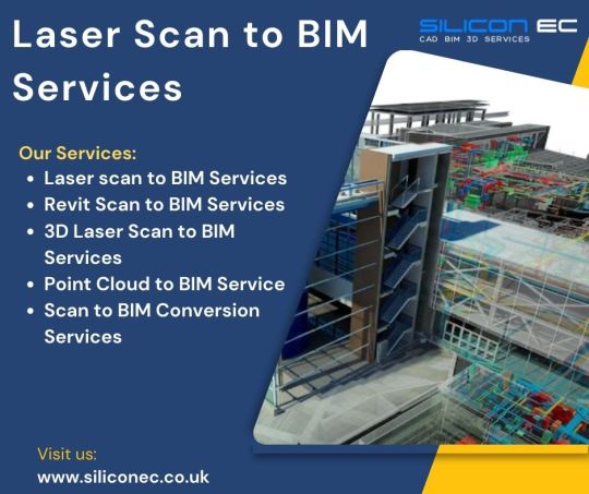
Silicon EC UK Limited offers comprehensive Laser Scan to BIM Services in the UK, catering to the evolving needs of the construction and architectural industries. Our experienced team of engineers and BIM specialists transforms raw scan data into intelligent 3D models, seamlessly integrating them into the BIM environment. Our team of experienced professionals utilizes state-of-the-art equipment to conduct comprehensive laser scans, generating highly detailed point clouds that serve as the foundation for creating accurate 3D models.
Choose Silicon EC UK Limited for comprehensive Laser Scan to BIM Services in Bristol, UK, and experience the difference in precision, reliability, and innovation for your next Building project.
For More Details Visit our Website:
#Laser scan to BIM Services#Revit Scan to BIM Services#3D Laser Scan to BIM Services#Point Cloud to BIM Service#Scan to BIM Conversion Services#BIM Services Video#Scan to BIM Services Video#CAD Services#Laser Scan to BIM Services Video#Viral Video
0 notes
Text

Which Industries Benefit Most from 3D Laser Scanning Surveys in London?
In the heart of bustling industries lies an innovation that has transformed the landscape of surveying methods: 3D laser scanning surveys in London. This technology has transcended traditional surveying practices, offering unparalleled precision, efficiency, and a comprehensive view of landscapes, structures, and spaces.
0 notes
Text

Gsource Technologies stands at the forefront of cutting-edge technology, offering Scan to BIM services that redefine precision and efficiency. Specializing in 3D Laser Scanning, the company seamlessly transforms intricate CAD drawings into detailed Building Information Models (BIM).
This transformative process not only enhances accuracy but also streamlines project workflows. Gsource goes beyond the conventional, creating a comprehensive 3D model that encapsulates the essence of architectural and engineering intricacies. Their commitment to excellence ensures that clients receive unparalleled Scan to BIM solutions, facilitating seamless integration and collaboration. Elevate your project with Gsource Technologies, where innovation converges with expertise for a truly dynamic digital transformation.
#gsourcetechnologies#architecturedesigns#engineeringdesigns#caddrafting#bimservices#bimsolutions#bim3dmodel
2 notes
·
View notes
Text
What is the Turnaround Time for Dallas 3D Laser Scanning?
Reality IMT Inc As industries across Dallas continue to embrace advanced technology for design, construction, and facility management, 3D laser scanning has become an essential tool for gathering accurate, real-time spatial data. Whether you're working on a commercial building renovation, manufacturing facility upgrade, or infrastructure documentation, one critical factor to consider is turnaround time—how long it takes from scanning a site to receiving usable deliverables.
In this article, we’ll explore the typical turnaround time for 3D laser scanning services in Dallas, the key factors that influence delivery timelines, and how you can speed up the process for your project.
Understanding 3D Laser Scanning and Its Workflow
3D laser scanning is the process of using specialized equipment—such as terrestrial laser scanners—to capture detailed measurements of a physical space or object. The scan generates a point cloud, which can be processed into as-built models, CAD files, BIM models, 2D floor plans, or other visual and data-rich outputs.
The process typically involves:
Initial consultation and site evaluation
On-site scanning
Post-processing and data registration
Deliverable creation (e.g., CAD drawings or 3D models)
Review and revisions (if required)
Each phase has its own time requirements depending on project size and complexity.
Typical Turnaround Time in Dallas
The average turnaround time for 3D laser scanning projects in Dallas ranges from 2 days to 3 weeks, depending on several factors. Here’s a general breakdown based on project size and scope:Project TypeEstimated Turnaround TimeSmall residential scan (under 3,000 sq. ft.)2–5 business daysMedium commercial building (10,000–30,000 sq. ft.)1–2 weeksLarge industrial or multi-level facility2–3 weeksComplex infrastructure projects3+ weeks
These timelines typically include scanning, post-processing, and delivery of requested outputs. However, more complex models or expedited schedules may affect these estimates.
Key Factors That Influence Turnaround Time
While the size of the project is a major factor, several other considerations can influence how quickly you’ll receive your deliverables from a 3D laser scanning provider in Dallas.
1. Project Scope and Size
Larger spaces require more scanning setups and data capture, increasing both scanning time and post-processing efforts. A single-family home may take just a few hours to scan, while a 100,000-square-foot warehouse could take several days.
2. Type of Deliverables Needed
Do you need only a raw point cloud? Or do you require BIM models, 2D drawings, topographic maps, or Revit-compatible files?
Raw point clouds can be delivered quickly—often within 1–3 days.
Fully processed BIM models may take 1–2 weeks or more depending on the level of detail required.
3. Level of Detail (LOD)
The Level of Detail (LOD) refers to how refined and comprehensive the final models are. LOD 100–200 is relatively quick to produce, while LOD 300–500 (common for construction or fabrication) requires more modeling time.
4. Post-Processing Time
Post-processing involves registering point clouds, cleaning noise, aligning scans, and preparing them for further use. This is typically one of the most time-consuming parts of the project, especially when high precision is needed.
5. Scheduling and Availability
Turnaround time also depends on the provider’s schedule. If you're working with a busy Dallas-based 3D scanning firm, you may need to wait a few days just to get on-site. Always book in advance if you're working with tight construction timelines.
6. Revisions and Client Feedback
If multiple review cycles or revisions are involved, the overall timeline may extend. Clear communication of project needs up front can help minimize these delays.
Expedited 3D Laser Scanning in Dallas: Is It Possible?
Yes, many 3D scanning providers in Dallas offer expedited services for urgent projects. In such cases, you might receive raw point clouds in 24–48 hours, and detailed deliverables within 3–5 business days, depending on complexity.
However, expedited service usually comes with additional costs, which can range from 20% to 50% above standard pricing. It’s ideal for:
Emergency facility repairs
Time-sensitive construction schedules
Last-minute documentation for permitting
Be sure to ask your provider about their fast-track options and how they manage quick turnarounds without sacrificing quality.
Typical Workflow Timeline (Step-by-Step)
Here’s a look at a sample workflow and the typical time each step takes for a standard commercial project in Dallas:StepTimeframeInitial consultation & quote1–2 business daysOn-site scanning (10,000 sq. ft.)1 dayData processing & registration2–5 business daysDeliverable creation (2D plans or 3D model)5–10 business daysReview & adjustments1–3 business daysTotal Estimated Time7–15 business days
This can vary significantly based on deliverable type, data complexity, and whether revisions are needed.
Tips to Speed Up Turnaround Time
If you’re under tight deadlines, here are a few tips to help you receive your scan results as quickly as possible:
✔ Be Clear on Project Goals
Outline exactly what you need—such as floor plans, BIM models, or mesh models—so the provider can allocate the right resources.
✔ Prepare the Site
Ensure the site is clean, accessible, and safe for the scanning team. Removing unnecessary obstructions helps the scanner collect clean data faster.
✔ Choose a Local Provider
Working with a Dallas-based scanning service helps reduce travel delays and ensures faster on-site response.
✔ Ask About File Format Compatibility
Let your provider know your preferred file types (e.g., .rcs, .e57, .dwg, .rvt). Mismatched formats can delay project handoff.
✔ Schedule Ahead
If your project is part of a larger workflow, book scanning services early so they align with your timeline.
Dallas Industries That Rely on Fast 3D Scanning
Several industries in Dallas benefit from quick-turnaround scanning solutions:
Construction & Contracting: Fast as-built scans for renovation and retrofits
Architecture & Design: Quick access to site dimensions for planning
Manufacturing: Plant layout documentation for equipment installation
Real Estate & Facilities Management: Floor plans and 3D tours for marketing and space utilization
Civil Engineering & Infrastructure: Survey-grade data for public works and infrastructure upgrades
Speed and precision are especially crucial in urban environments like Dallas, where construction and development projects often face tight deadlines and regulatory timelines.
Conclusion
The turnaround time for 3D laser scanning in Dallas depends on multiple factors, including the size of the project, the level of detail required, and the type of deliverables. While small projects may be completed in 2–5 days, larger and more complex assignments can take up to 3 weeks or more.
Understanding the process and planning ahead will help ensure your project stays on schedule. Whether you're scanning a single room or an entire facility, partnering with an experienced Dallas-based 3D laser scanning provider is the key to getting accurate results—on time.
Need fast and accurate 3D laser scanning in Dallas? Reach out to local professionals who can deliver the data you need—when you need it most.
Let me know if you'd like to localize this article further with specific Dallas-based companies or keywords!
Contact us: Reality IMT Inc Serving Dallas TX 469-277-7550 https://realityimt.com/3d-scanning-services-dallas-texas/

#3D Laser Scanning Service Dallas#3D Laser Scanning Dallas#3D Building Scanning Services#3d building scanning#3D Laser Scanning Services#3d laser scanning construction#3D Measurements Services
0 notes
Text
Why Houston Dentists in Tanglewood Are a Trusted Choice for Quality Family Dental Care
When it comes to oral health, finding a reliable and skilled dentist close to home can make all the difference. For many families and professionals in Houston, the search often leads to Houston dentists Tanglewood—a neighborhood known for combining upscale living with access to top-tier dental care.
But what makes this area’s dental professionals stand out? Whether you're scheduling a routine check-up or need urgent help from a broken tooth repair dentist, here’s what you should know about seeking care in Tanglewood.

A Neighborhood Built on Excellence—Including Dentistry
Tanglewood isn’t just one of Houston’s most desirable residential communities; it’s also home to some of the most established dental practices in the city. The local Houston dentists Tanglewood residents trust often carry decades of experience, along with access to modern technology that makes both diagnostics and treatment more precise.
Many practices here are family-run or multi-generational, providing not just clinical expertise but also a patient-first approach rooted in community values. This balance of professionalism and personal care is one of the biggest reasons patients stay with the same Tanglewood dental office for years—if not decades.
Full-Spectrum Dental Services All Under One Roof
Another strong advantage of choosing a dentist in Tanglewood is the comprehensive nature of the care provided. Most clinics in the area offer everything from preventive cleanings and cosmetic treatments to emergency services and advanced restorative work.
If you’re looking for a broken tooth repair dentist, for example, you won’t have to search far. Tanglewood-based dentists are well-equipped to handle everything from minor chips to complex fractures. Depending on the severity, treatment might include bonding, a crown, or even an onlay—each customized to restore the tooth’s appearance and function without delay.
Some practices even offer same-day crowns using CAD/CAM technology, which eliminates the need for temporary solutions or multiple appointments.
What to Expect from a Houston Dentist in Tanglewood
Choosing the right dental provider often comes down to the details. Here’s what you can typically expect when visiting Houston dentists Tanglewood residents recommend:
Thorough Consultation and Treatment Planning: Initial visits usually include digital imaging, detailed exams, and time set aside to discuss your concerns in depth.
Modern, Comfortable Facilities: Many clinics in this area are newly renovated or built with patient comfort in mind, including quiet operatories, ergonomic seating, and low-radiation imaging systems.
Specialized Expertise: Whether you're seeking preventive care, cosmetic upgrades, or need a reliable broken tooth repair dentist, chances are your local Tanglewood provider has handled it countless times.
Flexible Scheduling and Payment Options: A growing number of dental offices in the area offer extended hours, weekend appointments, and in-house financing to accommodate busy lifestyles.
What to Look for When Choosing a Tanglewood Dentist
With so many reputable providers to choose from, how do you narrow it down? Start by focusing on:
Credentials & Continuing Education: Ensure your dentist is licensed and committed to staying up-to-date with the latest advancements in dental care.
Patient Reviews & Testimonials: Hearing directly from other patients can offer insight into how well a practice communicates, handles anxiety, and follows through with results.
Technology & Techniques: Advanced equipment like digital impressions, laser therapy, and 3D scanning can dramatically improve both comfort and outcomes.
Even better, many Houston dentists Tanglewood patients rely on offer in-office tours for first-time visitors—allowing you to meet the team, explore the space, and ask questions before committing to treatment.
Emergency Dental Care with Trusted Professionals
A chipped or broken tooth doesn’t always give you time to plan. When you need urgent care, having a go-to broken tooth repair dentist nearby can spare you unnecessary pain and stress. Many Tanglewood practices offer same-day appointments for dental emergencies, which is another reason they’re so highly regarded.
Instead of waiting in pain or resorting to a general urgent care center that may not specialize in dental trauma, you can be treated quickly and correctly by someone who understands both the medical and aesthetic considerations of restoring damaged teeth.
Final Thoughts: Your Smile Deserves Expert Care
Whether you’re settling into the Tanglewood neighborhood or simply want a higher standard of dental care, searching for Houston dentists Tanglewood is a smart place to begin. From preventive care to emergency services, these providers bring expertise, compassion, and attention to detail that truly set them apart.
If you’ve been putting off a check-up or are dealing with discomfort from a dental injury, don’t wait. Reach out to a nearby broken tooth repair dentist or schedule a consultation with one of the many reputable providers in the area. Your smile—and your health—will thank you.
#DentalCleaning#teethcleaning#FamilyDentist#veneers#RootCanal#DentalEmergency#porcelainveneers#InvisalignDentist#TeethWhiteningDentist#dentistemergency#sedationdentist#localdentist#dentalimplant#dentalveneers#emergencyoralsurgeon#DentalSpecialist
0 notes
Text
Top 6 Proven Best Practices to Optimize Your Scan to BIM Workflow

With the integration of 3D laser scanning services within BIM workflows in the AEC industry, the way experts approach design, remodeling, and facility management projects has been completely transformed. Scan to BIM, which transforms laser-scanned data into detailed Building Information Models, makes accurate depictions of existing structures possible.
Workflow optimization is crucial for efficient Scan to BIM Services to guarantee high-quality deliverables.
Get the most out of your 3D Scan to BIM projects with these tried-and-true best practices.
Defining Clear Project Scope and Purpose
Establishing the goals and scope of a project is one of the most critical phases in the 3D Scan to BIM process. This step is essential, as the defined objectives will determine which areas require the most focus and the level of detail necessary for data collection.
For instance, if one is remodeling a historic structure, it might require exact scans of complex architectural elements. On the other hand, a simple structural update may call for less thorough scans, prioritizing significant structural components.
By adopting a selective and strategic approach to scanning, it is possible to reduce project costs significantly and conserve considerable time in data processing.
Defining Scope for Efficient Workflows
The Point Cloud to BIM services involve a streamlined process with clarity of project scope, eliminating the need to collect excessive data and targeting only pertinent point cloud data from the beginning.
To collect accurate data, team members can use specific scanning methods, viewpoints, and resolutions, which help reduce processing time and data storage requirements.
Success Story: 97,000 Sq.Ft. of Scan to BIM Conversion in Just 27 Days
Invest in Quality-oriented 3D Laser Scanning Services
A successful Scan to BIM workflow is built on top-notch 3D laser scanning services. Reliable BIM models depend on accurate, comprehensive, clean point cloud data, documented by skilled scanning professionals. The project's success is also impacted by the caliber of laser scanning equipment and offered precision and accuracy.
Selecting the Right Equipment and Service Provider
Mobile and drone-based scanners are well-suited for large-scale or difficult-to-reach locations while terrestrial laser scanners are extremely accurate for stationary scans of complicated situations.
If 2D drawings are required in addition to BIM models, working with scanning providers who specialize in Scan to CAD Services can improve data output.
Significance of Pre-Scan Planning
By conducting a thorough pre-scan planning session, the Scan to BIM services provider can have a deeper understanding of the project's complexity.
Teams can discuss specific areas that require the greatest level of accuracy and identify potential issues to create a scanning strategy.
Streamline Point Cloud Data Processing
The next crucial stage in the Point Cloud to BIM workflow is processing the Point Cloud data after completing site scans.
Proper cleaning, filtering, and segmenting of large raw point cloud data is essential. A cloud of millions of points is transformed into manageable, structured data in this step, which facilitates its interpretation and manipulation in BIM software.
Cleaning and Organizing the Point Cloud Data
Noise and extraneous data can diminish the effectiveness of 3D BIM modeling.
Filtering and noise-reduction features in point cloud processing software automatically clean up the data by organizing the data, such as labeling and segmenting various building aspects.
Leveraging Automated Tools
By decreasing the time spent on manual editing, automated software like Autodesk ReCap and Cloud Compare, can improve workflow efficiency and enable BIM specialists to concentrate on more intricate areas of model creation.
To help teams distinguish components within the point cloud and obtain more detail when transferring data from 3D Laser Scanning Services to BIM, several of these tools include color-coding and data segmentation.
Read More: How Al Enhances the Accuracy of Scan to BIM Models?
Effective Collaboration among Stakeholders
Architects, engineers, contractors, and facility managers are among the many stakeholders who collaborate on Scan to BIM projects. Effective teamwork is crucial to keep everyone on the same page regarding project objectives and prevent expensive delays.
Real-time data sharing and editing are now made possible by cloud-based platforms and BIM-specific collaboration tools, which are imperative to project success.
Real-Time Collaboration and Issue Resolution
Using cloud-based solutions profoundly benefits the AEC teams by enabling simultaneous access to updated project information.
Architectural teams can discuss changes with engineering teams, inspect 3D models, and annotate them in real-time, minimizing the probability of errors that could later cause the project failure.
Utilizing Common Data Environments
Common data environments (CDEs) offer a single location to store and retrieve project files, model updates, and notes.
With features like version control, automated update alerts, and authorization settings, tools like Autodesk BIM 360 or Trimble Connect make collaboration easy.
CDEs minimize inconsistencies and expedite decision-making in Scan to BIM Services by guaranteeing that each team member utilizes the most recent model version.
Regular Review Meetings and Checkpoints
Regular project meetings with all stakeholders are equally important along with technological measures.
These gatherings offer chances to discuss potential difficulties, address problems, and assess project progress.
A productive work environment and high-quality results for Point Cloud to BIM conversions are fostered by ensuring alignment among scanning experts, BIM modelers, and project managers.
Read More: Scan to BIM vs Traditional Methods : Which is Best for Your Project?
Invest in Scalable Technology
It is crucial to use scalable technology and software to manage big datasets, particularly for intricate or lengthy projects.
Even on larger projects, teams may prevent bottlenecks and guarantee seamless processing by investing in strong workstations, lots of data storage, and cloud computing solutions.
Incorporate Visual References
Context, material details, and texture information can be added to the BIM model by integrating high-resolution photos with point cloud data. Photographic data and 3D laser scanning services combine to create a more visually complete model that is very helpful for documentation and facilities management.
AI-powered Scan to BIM Services for Efficient Workflows
The AEC firms can convert architectural Scan to BIM models in just 1 day using AI-powered services by ScantoBIM.online. The AI tool provides unparalleled accuracy and quality while minimizing human intervention.
The companies can choose from 100+ architects and engineers with specialized skills and expertise, ensuring precise execution of projects.
Key Features
Advance AI tools and plugins for affordable solutions
Advanced AI tools can convert 10,000 sq ft of Scan to BIM with 1 day turnaround time
Quality control tool to check 100+ parameters in models, ensuring consistency
Conclusion
In addition to increasing model generation speed and accuracy, a well-optimized scan to BIM workflow guarantees BIM models with detailed information and insights for continued facility management. Project teams can produce dependable BIM models that last over time by establishing project goals, investing in premium 3D laser scanning services, efficiently organizing point cloud data, and encouraging stakeholder cooperation.
By following these best practices, the AEC firms can make better decisions, reduce expensive rework, and ensure that the 3D Scan to BIM services result in high-value outcomes for every project.
#Scan to BIM Services#3D Scan to BIM services#3D laser scanning services#Point Cloud to BIM Sevices#Point Cloud to revit sevices
0 notes
Text
Why Fire Protection BIM modeling in Illinois is Essential for Modern AEC Projects
Building Information Modeling (BIM) is already revolutionizing the way projects are designed, coordinated, and managed. When applied specifically to fire safety systems, BIM modeling becomes a powerful tool to design and document sprinkler layouts, fire suppression systems, smoke alarms, emergency lighting, and other life-saving infrastructure with unmatched precision.
Using 3D digital models, engineers and contractors can visualize and coordinate fire safety systems early in the design process, reducing conflicts and change orders during construction. It also ensures compliance with the National Fire Protection Association (NFPA) codes and Illinois fire codes.
Why Fire Protection BIM Modeling Matters in Illinois
Illinois, home to both dense urban cores like Chicago and sprawling suburban developments, requires a tailored approach to fire safety. Local authorities have stringent fire codes, especially in high-rise construction, commercial spaces, and health care facilities.
Fire Protection BIM Modeling in Illinois plays a pivotal role in satisfying both design and safety requirements. The ability to run clash detection simulations, ensure sprinkler head clearance, and coordinate with architectural and MEP systems before construction begins reduces costly rework and shortens project timelines.
Key Benefits for Illinois-Based Projects
Code Compliance: Ensures adherence to Illinois fire codes and NFPA standards.
Early Detection of Conflicts: Identifies design issues before they reach the construction phase.
Increased Collaboration: Streamlines communication between architects, engineers, and contractors.
Facility Management: Post-construction, BIM data supports maintenance and emergency preparedness.
Who Needs This?
If you’re a general contractor working on commercial developments in Chicago, a design engineer on a hospital project in Springfield, or a building owner updating an old warehouse in Rockford — you’ll benefit from integrating Fire Protection BIM Modeling into your project.
It’s especially useful for:
Healthcare facilities with strict evacuation route standards
Education institutions needing fire suppression for lab buildings
Warehouses with automated fire systems
High-rise residential towers requiring multi-zone protection
What Sets BIM Apart from Traditional Fire Protection Design?
Traditional 2D drawings and spreadsheets can’t capture spatial relationships or system interdependencies. BIM models, however, bring a level of intelligence and collaboration unmatched by older methods.
By implementing BIM for fire safety systems, you’re not just complying with regulations you’re actively optimizing safety, cost, and time efficiency.
Where Does This Fit in the Construction Workflow?
Fire Protection BIM Modeling fits best during the design development and pre-construction phases. This timing allows fire system designers to work closely with MEP consultants and structural engineers, ensuring coordinated and compliant installations.
It also integrates with 4D (time) and 5D (cost) simulations to help project stakeholders understand not only how systems will be built, but also how long they will take and how much they will cost.
Choosing the Right Partner
If you’re considering Fire Protection BIM Modeling in Illinois, it’s essential to work with specialists who understand Illinois fire codes, construction workflows, and Building Information Modeling technologies.
Clove Technologies stands out in this space. Their team delivers highly accurate, code-compliant fire safety systems tailored to the needs of Illinois construction. Whether it’s a large commercial project or a specialized facility, Clove Technologies ensures that fire safety is engineered right from the start.
Check out this blog on Electrical BIM Modeling in Florida
Contact Us now : [email protected]
Keywords : Plumbing BIM modeling, Mechanical BIM modeling in Texas, Fire Protection BIM modeling in Texas, Low Voltage BIM modeling in Florida, Plumbing BIM modeling in Georgia, Mechanical BIM modeling in Illinois, Fire Protection BIM modeling in Illinois, Electrical BIM modeling California, Low Voltage BIM modeling, California BIM modeling in Georgia, Scan to BIM, Scan to BIM in Georgia, H.V.A.C 3D Modeling in US / USA, Plumbing 3D Modeling, H.V.A.C 3D Modeling.
0 notes
Text
Expert Scan to BIM Services in Germany | Scan to CAD | Rvtcad
Germany is a leader in advanced architectural and engineering solutions, with a growing demand for scan-to-BIM and scan-to-CAD services. These technologies help architects, engineers, and construction professionals transform real-world buildings into precise digital models. Rvtcad specializes in delivering high-quality scan-to-BIM services across Germany, ensuring accurate and efficient project execution.

What is Scan to BIM?
Scan to BIM is a process where laser scanning technology captures detailed 3D measurements of a building. These scans are then converted into accurate Building Information Models (BIM) using software like Revit. BIM models provide detailed architectural, structural, and MEP (Mechanical, Electrical, and Plumbing) information, allowing seamless planning, design, and execution of projects.
Why Choose Rvtcad for Scan to BIM Services in Germany?
Highly Accurate 3D Models: We use advanced laser scanning equipment to create precise BIM models, reducing errors and project delays.
Expertise in Revit & AutoCAD: Our team specializes in converting point cloud data into Revit models with various Levels of Development (LOD 100 to 500).
Fast and Reliable Service: We ensure quick turnaround times for as-built documentation, renovations, and new constructions.
Clash-Free Coordination: Our BIM models help in clash detection, ensuring smooth collaboration between architects, engineers, and contractors.
Customized Solutions: Whether it's a residential, commercial, or industrial project, we tailor our services to meet specific client needs.
What is Scan to CAD?
Scan to CAD converts point cloud data into 2D AutoCAD drawings, such as floor plans, elevations, and sections. This process is essential for architects, engineers, and facility managers who require accurate as-built documentation.
Our Scan to CAD Services Include:
Sections & Site Plans
Detailed As-Built Drawings
MEP & Structural Drawings
Topographic & Survey Drawings
Industries We Serve in Germany
Rvtcad provides Scan to BIM and Scan to CAD services across multiple industries, including:
Architecture & Construction
Engineering & Infrastructure
Facility Management
Historical Building Preservation
Real Estate & Renovation
Advantages of Using Scan to BIM & CAD Services
Time-Saving: Faster project planning and execution.
Cost-Effective: Reduces rework and minimizes material waste.
High Accuracy: Eliminates manual measurement errors.
Better Collaboration: Enhances teamwork among stakeholders.
Contact Rvtcad for Expert Scan to BIM & CAD Services in Germany
If you need high-quality Scan to BIM or Scan to CAD services, Rvtcad is your trusted partner. We offer precision, reliability, and efficiency to help you achieve project success. Get in touch today to discuss your project requirements!
#scan to bim#point cloud to bim#3d laser scanning#bim services#as-built drawing#bim laser scanning#scan to revit#scan to cad#as-built drawings#point cloud to cad
0 notes
Text
Get the Best Laser Scan to BIM Services in Bristol, UK
Silicon EC UK Limited offers comprehensive Laser Scan to BIM Services in Bristol, UK, catering to the evolving needs of the construction and architectural industries. Our experienced team of engineers and BIM specialists transforms raw scan data into intelligent 3D models, seamlessly integrating them into the BIM environment. Our team of experienced professionals utilizes state-of-the-art equipment to conduct comprehensive laser scans, generating highly detailed point clouds that serve as the foundation for creating accurate 3D models. Our services empower clients to streamline project planning, enhance construction coordination, and minimize errors, ultimately leading to improved project outcomes and cost savings. Our commitment to excellence, combined with a collaborative approach, ensures seamless communication and transparency at every stage of the BIM project.
Supports and software facility:
Our dedicated workforce comprises steadfast QC heads, proficient Team Leads, and experienced Engineers who possess extensive expertise. Our BIM Services adeptly utilize cutting-edge software, including AutoCAD, Tekla Structure, and Revit Structure, showcasing a commitment to staying at the forefront of technological advancements.
We are a BIM Engineering Company that presents BIM Engineering Services Bristol and other cities covering London, Liverpool, Manchester, York, Leeds-Bradford, Glasgow, Newcastle, Sheffield, and Sunderland.
Choose Silicon EC UK Limited for comprehensive Laser Scan to BIM Services in Bristol, UK, and experience the difference in precision, reliability, and innovation for your next Building project.
For More Details Visit our Website:
#Laser Scan to BIM Services#Revit Scan to BIM Services#3D Laser Scan to BIM Services#Point Cloud to BIM Service#Scan to BIM Conversion Services#Scan to BIM Services#BIM Services#Building Information Modeling Services#Building Information Modeling#BIM#BIM Services Bristol#BIM Engineering Services UK#BIM Services UK#Laser Scan to BIM Services Bristol#Scan to BIM Services UK#CAD Design#CAD Drafting#CAD Drawing#Engineering Services#Engineering Company#Engineering Firm
0 notes
Text

The Future of Scan to BIM in London
Scan to BIM in London is a technology that uses 3D laser scanning to create a digital model of a building or structure. This model can then be used for a variety of purposes, such as planning, design, construction, and maintenance.
0 notes
Text
Your Trusted Dental Clinic in Bangalore – Excellence in Every Smile
Looking for a reliable and expert dental clinic in Bangalore? Whether you need a routine dental check-up or a complete smile makeover, finding the right dental care provider is essential. At [Your Clinic Name], we combine advanced dental technology, experienced specialists, and patient-first care to ensure you receive the best oral health treatment in the city.
🏥 Why Choose Our Dental Clinic in Bangalore?
Bangalore is home to a number of dental clinics, but here's what sets us apart:
✅ Highly Qualified Dentists & Specialists
Our team consists of experienced general dentists and certified specialists in orthodontics, periodontics, endodontics, oral surgery, pediatric dentistry, and prosthodontics. This ensures that you get expert care for all types of dental issues — all under one roof.
✅ Advanced Dental Technology
We are equipped with modern tools such as:
Digital X-rays and 3D scanning
Painless laser treatments
Intraoral cameras
CAD/CAM for same-day crowns
Clear aligner solutions like Invisalign
✅ Hygienic and Comfortable Environment
We strictly follow international sterilization protocols and maintain a clean, safe, and relaxing environment to ensure a stress-free dental experience for every patient.
🦷 Our Dental Services
We offer a full range of dental treatments for patients of all ages:
General Dentistry: Cleanings, fillings, preventive care
Orthodontics: Braces, clear aligners, and retainers
Root Canal Treatment: Pain-free procedures with precision
Cosmetic Dentistry: Teeth whitening, veneers, smile design
Dental Implants: Permanent solutions for missing teeth
Pediatric Dentistry: Gentle dental care for children
Gum Treatment: Scaling, deep cleaning, and laser therapy
Wisdom Tooth Removal & Oral Surgery
💬 What Our Patients Say
“Best dental clinic in Bangalore! The doctors are professional, caring, and explain everything in detail. My root canal treatment was completely painless.” — Ravi S., Bangalore
“Highly recommend for kids! My son felt so comfortable with the pediatric dentist here. The whole team is amazing.” — Anjali M., Koramangala
📍 Conveniently Located in Bangalore
We are centrally located with easy access from major areas like Koramangala, Indiranagar, HSR Layout, and Whitefield. Whether you're coming in for a regular check-up or an emergency dental visit, we ensure minimal waiting time and quick appointments.
0 notes
Text
What a Land Surveyor Does—and Why You Need One
A Land Surveyor is a trained professional responsible for measuring and mapping land boundaries, elevations, and features. Their work forms the foundation of property development, infrastructure projects, and legal land transactions across Australia. Whether it's for a residential subdivision, commercial development, or government infrastructure, the services of a Land Surveyor are essential to ensure precision, legal clarity, and regulatory compliance.

Key Responsibilities of a Land Surveyor
The duties of a Land Surveyor extend far beyond marking property lines. Their core responsibilities include:
Boundary Surveys: These define the legal perimeters of a parcel of land. This is particularly important for resolving disputes or clarifying ownership before construction begins.
Topographic Surveys: These involve mapping the contours and features of a landscape, such as hills, trees, and water bodies. Developers and architects use this information during the planning and design phase.
Construction Surveys: During a construction project, a Land Surveyor provides precise data that guides the positioning of buildings, roads, and other infrastructure.
Subdivision Planning: When landowners or developers want to divide a parcel into smaller lots, a Land Surveyor prepares the layout and submits it for approval to local authorities.
Engineering Surveys: These surveys provide critical support for major infrastructure projects like roads, bridges, and pipelines by ensuring structural design matches site conditions.
Easement and Right-of-Way Surveys: A Land Surveyor helps in identifying and documenting legal access rights across properties, crucial for utilities and shared property access.
When You Need a Land Surveyor in Australia
Engaging a Land Surveyor is a smart and often legally necessary step in various scenarios:
Purchasing or Selling Property: Clarifying boundaries ensures buyers and sellers have a clear understanding of what is being transacted, avoiding future disputes.
Building or Renovating: Before construction begins, accurate land measurements ensure compliance with local building codes and avoid encroachment issues.
Land Subdivision: Dividing a property for sale or development requires official boundary surveys and submission to local councils.
Resolving Disputes: Property line disagreements with neighbours can escalate quickly. A certified Land Surveyor provides the authoritative measurements needed to resolve conflicts.
Infrastructure Development: Government agencies and private developers rely on Land Surveyors to provide data that shapes long-term infrastructure projects.
Legal and Regulatory Importance
In Australia, a Land Surveyor must be licensed and often registered with the state or territory's surveying board. Their surveys carry legal weight and are recognised by courts, councils, and financial institutions. Accurate surveying ensures that land use complies with zoning regulations, environmental guidelines, and planning legislation.
Each state, such as New South Wales, Victoria, Queensland, and Western Australia, has its own standards and regulatory bodies overseeing the practice. Only a licensed Land Surveyor can lodge official survey plans or offer services like boundary redefinition.
Technology and Tools Used by Land Surveyors
Modern Land Surveyors use advanced technology to deliver accurate and reliable results. Some of the tools and methods include:
Total Stations: Devices that combine electronic distance measurement and angle measurement for precision.
GPS Surveying: Global Positioning Systems provide location data used in large-scale mapping and remote areas.
Drones and Aerial Surveys: These are used to map large or inaccessible areas quickly and cost-effectively.
3D Laser Scanning: This creates highly accurate 3D models of terrain or structures.
CAD and GIS Software: After data collection, sophisticated software is used to analyse and present findings in detailed maps and plans.
Why Hiring a Land Surveyor Is a Sound Investment
Hiring a Land Surveyor is not just about legal compliance—it's a strategic decision that protects your investment. Accurate surveys prevent costly mistakes, delays in development, and legal battles over property lines. In construction, it ensures structural integrity and optimal site usage. For developers, it streamlines the approval process and boosts project efficiency.
Ignoring the need for a Land Surveyor can lead to serious complications such as encroachment, failed council inspections, or disputes that could end in court. In contrast, engaging a qualified professional provides peace of mind, legal clarity, and long-term value.
Conclusion
The role of a Land Surveyor is critical in the Australian property and construction sectors. From defining legal boundaries to enabling sophisticated infrastructure development, these professionals bring precision, expertise, and legal assurance to every project. Whether you're a homeowner, developer, or contractor, working with a licensed Land Surveyor ensures that your plans are built on solid ground—both literally and legally.
Choosing to involve a Land Surveyor early in any land-related venture is not only a matter of compliance but a proactive step towards successful outcomes.
0 notes