#AlternativeToGoogleMyMaps
Explore tagged Tumblr posts
Visit Tumblr Blog
Explore Tumblr blogs with no restrictions, modern design and the best experience.
Last Seen Tumblr Blogs


Fun Fact
1,644 Tumblr posts in 1 second.
Text
Best Alternatives to Google My Maps for Sharing Travel Stories
For many travelers, documenting and sharing itineraries visually has become just as important as the journey itself. But with Google My Maps reaching its limits in terms of customizability and collaboration, users are increasingly searching for more flexible, GIS-powered alternatives. The challenge is clear: how can one create rich, day-by-day travel narratives that are both interactive and informative without being restricted by basic plotting tools? That’s where modern story mapping solutions come in.

Why Traditional Mapping Tools Fall Short
Google My Maps is simple, but that simplicity can also be a limitation. When planning multi-day international trips like a week in any place, users often want more than just pins. They want to plot detailed locations, organize travel days, upload photos, write personal notes, and even collaborate with others—all without cluttering the map. Tools that rely purely on basic markers and labels can't deliver the depth required for serious travel storytelling.
GIS in Travel Storytelling
Geographic Information Systems (GIS) bring depth and structure to map-based storytelling. Unlike static maps, GIS-powered platforms allow travelers to create layered narratives by combining spatial data with multimedia elements. From tourism boards creating national heritage trails to travel bloggers curating personalized city walks, GIS has revolutionized the way stories are told through location. Not only does it enhance visualization, but it also allows a more organized, attribute-rich approach to storytelling.
Industries like ecotourism, cultural preservation, travel journalism, and local tourism boards are already embracing GIS to create immersive, shareable travel content. When paired with tools that support real-time collaboration, role-based access, and custom attributes (like accommodation type or transport mode), GIS becomes a storytelling engine, not just a map.
What Makes a Modern Story Mapping Tool Stand Out?
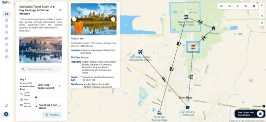
Imagine planning a Cambodia itinerary where each day is mapped with purpose. You begin by manually searching for addresses, dropping custom markers for landmarks like Angkor Wat, Phnom Penh markets, or Kampot’s riverside. You label them with titles like "Day 2 - Sunrise at Angkor," add brief descriptions, images from your camera roll, and even tag them with categories like "food stop" or "hiking trail."
Now imagine being able to preview the entire map as a story, share it through a private link, embed it in a blog, or even collaborate with a friend as a contributor or editor. That level of freedom isn’t science fiction anymore. Some platforms are quietly enabling exactly this kind of intuitive travel storytelling.

A Platform Worth Exploring
One such platform worth checking out is MAPOG. It allows users to plot travel journeys day-by-day, attach images and descriptions, and assign custom attributes that help you track every detail—from hotel check-ins to scenic routes. For bloggers and teams, the ability to share editable versions or simply allow viewers to explore your story map makes it a well-rounded alternative to Google My Maps. Though not mentioned often, it’s quietly making travel mapping far more intuitive.
In short, as the need for immersive travel sharing grows, switching to a more GIS-centered, customizable, and story-first platform can turn your trip into something not just remembered, but experienced by others.
0 notes