#Lake Chelan National Recreation Area
Text

North Cascades National Park, Washington, United States: North Cascades National Park is an American national park in the state of Washington. At more than 500,000 acres, it is the largest of the three National Park Service units that comprise the North Cascades National Park Complex. North Cascades National Park consists of a northern and southern section, bisected by the Skagit River that flows through the reservoirs of Ross Lake National Recreation Area. Lake Chelan National Recreation Area lies on the southern border of the south unit of the park. Wikipedia
70 notes
·
View notes
Text


This resource provides information about registering orchards or single fruit trees in the National Register of Historic Places. It also showcases the historical context of some orchards in the U.S. One such orchard is the Buckner Orchard at North Cascades National Park Service Complex here in Western Washington.
“In Lake Chelan National Recreation Area of the North Cascades National Park Service Complex, the Buckner Homestead Historic District contains a 90-year old apple orchard that reflects the revolutionary event in the modern period of orchard fruit growing: the discovery of the Delicious apple variety by the Stark brothers. This discovery transformed the growing of apples in the 20th century. Among the oldest trees of the Buckner orchard are the trees of the Common Delicious strain of the Delicious variety – Stark Brothers Nursery's name for the early, unimproved variety they acquired as “Hawkeye,” a red and yellow apple. The Buckner orchard is the oldest and largest known plantation of the variety in the United States and represents the advent of the Delicious variety before it was turned into a red apple, or Red Delicious variety, through strain selection in the 1920s.”
Citation:
Pacific West Regional Office, & Dolan, S., Fruitful legacy : a historic context of orchards in the United States, with technical information for registering orchards in the National Register of Historic Places (2009). U.S. Government Printing Office. Retrieved October 26, 2023, from https://hdl.handle.net/2027/pur1.32754081199857.
#govpubs#2000s#2009#NationalRegisterofHistoricPlaces#orchards#Bucknerorchard#WesternWA#NorthCascadesNationalParkService#Starkbrothers#RedDelicious#apples#OlmstedCenterforLandscapePreservation#culturalresources#registeringorchardsintheNRHP
4 notes
·
View notes
Text
A Guide to the Breathtaking Landscapes of North Cascades National Park in Washington

by Paige Guscott
Discover the awe-inspiring beauty of North Cascades National Park Washington. Immerse yourself in breathtaking landscapes and adventure.....
About North Cascades National Park Washington
Nestled in the northern part of Washington State, North Cascades National Park Washington is a hidden gem that boasts a number of breathtaking landscapes. The North Cascades National Park Service Complex, including the national park itself, Ross Lake, and Lake Chelan National Recreation Areas, together encompass an area that is truly captivating. Spanning over 500,000 acres, the park offers an immersive experience into the heart of nature. It's a hub of ecological diversity and geological marvels that welcomes approximately 30,000 visitors each year, according to the National Park Service, the organization that maintains all our national parks.
Photo by Ryan Stone on Unsplash
Northern Section of the North Cascades National Park Complex
The northern section of the North Cascades National Park Washington Complex is where the rugged beauty truly begins to unfold. This area is characterized by its steep, craggy peaks, including notable mountains like Mount Shuksan and Mount Baker - both iconic symbols of the Pacific Northwest's wilderness. These towering peaks are not just a paradise for climbers and hikers but also serve as critical habitats for a wide range of wildlife. From the elusive gray wolves and black bears to the majestic bald eagles soaring above, the biodiversity in this region is remarkable.
Venturing deeper into the northern part of the park, visitors will encounter the wonders of the alpine landscape. The park is renowned for its extensive networks of trails that meander through lush valleys, over serene streams, and under the shadows of towering ancient fir and cedar trees. One such trail, the Cascade Pass, offers an accessible yet profoundly rewarding hike, providing panoramic views of jagged peaks and glacier-clad mountains that define the North Cascades. The pass serves as a gateway to other remote areas, encouraging those who trek its path to explore further into the wilderness.
Ross Lake Section of North Cascades National Park Complex
National Park outside of Alaska. These icy giants contribute significantly to the park's dramatic landscape and are crucial for the water systems within the region. Melting glaciers feed rivers and streams, supporting a diverse aquatic ecosystem and supplying fresh water to the surrounding areas.
The Ross Lake section exemplifies this intricate relationship between glaciers and aquatic ecosystems. Ross Lake itself is a stunning, elongated reservoir nestled among steep, wooded hills and rocky peaks. A product of the damming of the Skagit River, this lake extends for over 20 miles and crosses into Canada, showcasing the international significance of the park's natural resources. The area around Ross Lake is popular among kayakers, anglers, and hikers who seek solitude and the thrill of exploring the backcountry. Several trails around the lake offer views that are as varied as they are stunning, from dense forest paths to high ridge walks with expansive vistas of the North Cascades.
Adjacent to Ross Lake is the equally mesmerizing Diablo Lake, known for its striking turquoise waters—a result of glacial flour that flows into the lake from nearby glaciers.
Lake Chelan Section of the North Cascades National Park Complex
Lake Chelan, another jewel within the North Cascades National Park Wahington Complex, further highlights the diversity and beauty of the region. This deep, fjord-like lake is one of the deepest in the United States and offers a unique landscape shaped by glacial forces over millennia. Surrounding the lake, steep mountainous terrain covered in lush forests provides a striking contrast to the clear blue waters. The Lake Chelan area is more remote and less accessible than other parts of the park, offering a more secluded experience for visitors seeking tranquillity amidst nature’s grandeur.
The lake's northern end is home to the small town of Stehekin, only accessible by boat, seaplane, or foot, which adds to its allure as a remote escape. Stehekin serves as a base for exploring the surrounding wilderness, with access to numerous trails that delve deep into the heart of the park. The area’s isolation has helped preserve its natural beauty and supports a lifestyle deeply connected to the environment.
Diverse Landscapes
What sets North Cascades national park Washington apart is its diverse array of landscapes and recreation areas. From rugged mountains that challenge even experienced climbers, to crystal clear lakes, there's something for every nature enthusiast. The lush forests invite hikers to wander through trails carpeted with pine needles and ferns, listening to the calls of local wildlife.
Exploring the Mountain Ranges
Looking up at the North Cascades, you are met with an array of jagged peaks that pierce the sky, some reaching elevations of over 9,000 feet. Among these natural skyscrapers, over 300 glaciers can be found in the park.....
Read More...
Read the full article
0 notes
Text

North Cascades National Park is an American national park in the state of Washington. At more than 500,000 acres (200,000 ha), it is the largest of the three National Park Service units that comprise the North Cascades National Park Complex. North Cascades National Park consists of a northern and southern section, bisected by the Skagit River that flows through the reservoirs of Ross Lake National Recreation Area. Lake Chelan National Recreation Area lies on the southern border of the south unit of the park. In addition to the two national recreation areas, other protected lands including several national forests and wilderness areas, as well as Canadian provincial parks in British Columbia, nearly surround the park. North Cascades National Park features the rugged mountain peaks of the North Cascades Range, the most expansive glacial system in the contiguous United States, the headwaters of numerous waterways, and vast forests with the highest degree of flora biodiversity of any American national park.
0 notes
Conversation
U.S. Daily Precipitation Records Tied/Broken 12/26/22
Eureka, California: 1.91" (previous record 1.55" 1945)
Merced, California: 0.8" (previous record 0.72" 2005)
Bear Mt. summit, Idaho: 1.8" (also 1.8" 1994)
Richfield, Idaho: 0.32" (previous record 0.26" 1917)
Alton, Illinois: 1" (previous record 0.7" 1987)
Gladstone Township, Illinois: 1" (previous record 0.59" 2016)
Evansville, Indiana: 1.7" (previous record 1.12" 2016)
Delano, Minnesota: 0.8" (previous record 0.33" 2015)
Banfield Mt. summit, Montana: 0.7" (previous record 0.6" 1994)
Flathead National Forest, Montana: 1.4" (previous record 1.3" 1980)
Kootenai National Forest, Montana: 0.9" (previous record 0.4" 2006)
Stahl Peak summit, Montana: 1.2" (previous record 0.7" 1992)
Unincorporated Hitchcock County, Nebraska: 0.06" (previous record 0.03" 2007)
Deschutes National Forest, Oregon: 1.8" (previous record 1.6" 2002)
King Mt. summit, Oregon: 2" (previous record 1.7" 2002)
Klamath Falls, Oregon: 0.32" (previous record 0.27" 2006)
Portland, Oregon: 2.12" (previous record 1.08" 1996)
Sexton Mt. summit, Oregon: 1.8" (previous record 1.65" 1958)
Sutherlin, Oregon: 1.11" (previous record 0.65" 2006)
Willamette National Forest, Oregon: 1" (previous record 0.9" 2006)
Marion, South Dakota: 1" (previous record 0.79" 2016)
Gifford Pinchot National Forest, Washington: 5.8" (previous record 5.3" 1994)
Harts Pass summit, Washington: 1.1" (previous record 0.9" 1994)
Unincorporated Kittitas County, Washington: 0.9" (previous record 0.6" 1994)
Lake Chelan National Recreation Area, Washington: 1.2" (also 1.2" 1994)
Langes Crest summit, Washington: 3.8" (previous record 1.7" 1998)
Unincorporated Lewis County, Washington: 1.07" (previous record 1.06" 1986)
Mt. Baker National Forest, Washington: 2.1" (previous record 1" 1994)
Mt. Crag summit, Washington: 3" (previous record 1.2" 2016)
Mt. Rainier National Park, Washington: 2.8" (previous record 2.4" 1994)
North Cascades National Park, Washington: 1.7" (previous record 0.9" 1994)
Okanogan National Forest, Washington: 0.5" (previous record 0.4" 1995)
Potato Hill summit, Washington: 2.2" (previous record 1.3" 1994)
Quinault Reservation, Washington: 4.4" (previous record 4.05" 1994)
Snoqualmie National Forest, Washington: 1.8" (previous record 1.7" 1996)
Tacoma, Washington: 1.24" (previous record 1.12" 1994)
Yakima, Washington: 0.54" (previous record 0.41" 2006)
Yakima Nation Reservation, Washington: 0.9" (previous record 0.6" 1996)
Parker Peak summit, Wyoming: 1.4" (previous record 0.5" 1995)
#Storms#U.S.A.#U.S.#Idaho#1910s#Illinois#1980s#Indiana#Minnesota#Nebraska#Oregon#Washington#1990s#Wyoming#Montana#1940s#1950s#Crazy Things
0 notes
Video
flickr
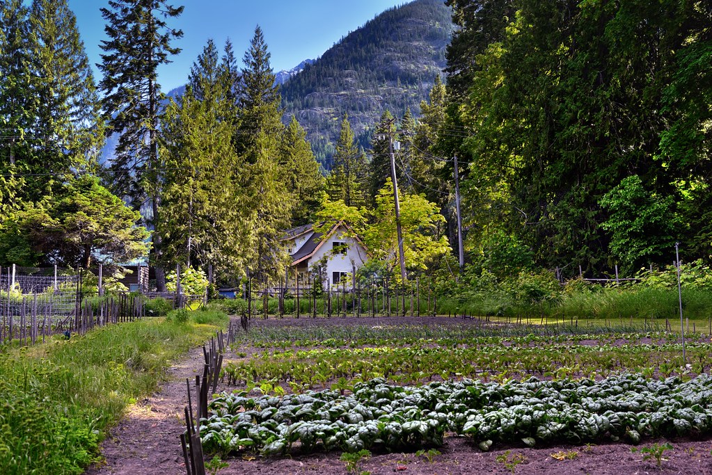
A Small Farm Nestled in the Mountains of Stehekin and the Lake Chelan National Recreation Area by Mark Stevens
Via Flickr:
Here I decided to take a more zoomed in look across this little farmland with the homes and trees all around. I also like how the mountains off in the distance added to that feeling of being nestled in a valley with tall things all around.
#Azimuth 179#Blue Skies#Bonanza Massif#Capture NX2 Edited#Cascade Range#Castle Rock#Central North Cascades#Color Efex Pro#Crops#Day 4#Electric Pole#Evergreen Trees#Evergreens#Fence#Fenceline#Hillside of Trees#Homes in Distance#Lake Chelan National Recreation Area#Landscape#Looking South#Mountains#Mountains in Distance#Mountains off in Distance#Nature#Nikon D800E#North Cascades#North Cascades National Park Service Complex#Outside#Pacific Ranges#Pole
12 notes
·
View notes
Text
Following the North Star
By Howard Shapiro
In our continuing series of posts focusing on the high points along the PCT in Washington the trial leads to the heart of the North Cascades and closes in on the final stretch to the Canadian border.

Agnes Creek near its union with the Stehekin River
Passing Glacier Peak and continuing north to the border is a time and a place of great excitement and anticipation. For some this is when the journey shrinks into single digit days while for others it may take a little longer. Like a sunrise the first rays of our destination barely beckon ahead. No matter which journey one finds themselves these final days north can be a great crescendo leading to the climax of getting to and crossing the border into Canada.
These last miles have been described as worthy competition to the enchanting miles through Yosemite and the John Muir Trail. Other places further south have their own distinction but these miles in the North Cascades can be a simple reminder of why we decided to walk this trail. The terrain is varied from exposed rocky ledges to high meadows and flower strewn passes. This is a place one won’t likely forget whether the weather is great, as it can be in August and September, or closed in with fog and cool rain as it also may be during this time.
Leaving Glacier Peak and its associated wilderness behind the trail makes its way toward the Agnes Creek drainage. This is the home to thousand year old western red cedars and Douglas firs that both loom overhead and protect us from an unexpected shower. Not far beyond Suiattle Pass there is a shortcut and a return to the old PCT. This leads down to Agnes Creek and eventually back to the newer route at Hemlock Camp. Staying on the longer, official PCT we are shown two bowls that were scraped and scoured by long ago glaciers. The first bowl is full of rocks that can be as big as houses reminding us once more of just how small we are in this world.

We are eventually in the Agnes Creek drainage and snaking along through old-growth forests. The Lake Chelan National Recreation Area is our next notable ‘official’ designated location. Here at High Bridge Trailhead along the Stehekin River Road there is a small shelter. Over the years the road has been blocked at various times so a ‘regularly scheduled’ National Park Service shuttle into the small village of Stehekin may not always be so ‘regular’ or exist at all. Nevertheless, here we are both close and far away from any thing closely resembling civilization. If you choose to go into Stehekin there will be people and a few attractions. If you don’t, then the solitude of the surroundings will envelope you. There are no bad choices.
Stehekin can be a wonderful detour for many hikers. Its location along the northwest shore of Lake Chelan makes It only accessible by foot, float plane, boat, or ferry. No roads from the outside will get you there. The translation for Stehekin is ‘the pass or the way through’. Sauk tribal people crossed the Cascade Crest over Suiattle Pass to trade with the Wenatchee people living to the west. This is a remote and gorgeous setting.
Stehekin was settled by the late 1880′s as a mining and trapping community. Neither of these really worked out. Some ranches remain but the prime support comes from recreation and seasonal residents. Much of the land is managed and owned by the National Park Service since this area is encompassed into the Lake Chelan National Recreation Area. This is one of the four areas that make up North Cascades National Park.

Returning to the trail at High Bridge trailhead (assuming you have taken the shuttle) or the five mile further on Bridge Creek trailhead the PCT climbs 3,225 feet toward Washington State Highway 20 (The North Cross Highway) to Rainy Pass. From here the story will continue in a following post. At this point adrenalin is building as are the sights and sounds as you edge ever closer to the border following the North Star.
#Stehekin#Agnes Creek#North Cascades#North Cascades National Park#Lake Chelan National Recreation Area#Suiattle Pass#Sauk Tribe#North Cross Highway
9 notes
·
View notes
Photo

Lake Chelan National Recreation Area - Washington - USA (by Mark Stevens)
#Lake Chelan National Recreation Area#Washington#US#USA#United States#North America#Anmerica#Nature#Landscape#Outdoor#View#Rural#Countryside#Photography#Travelling#Traveling#Travel#Tourism#Holiday#Urlaub#Reisen
1K notes
·
View notes
Text
Bowan Mountain on Rainbow Ridge via McAlester Pass / 波恩山
Bowan Mountain on Rainbow Ridge via McAlester Pass / 波恩山
Bowan Mountain above Rainbow Lake sits on Rainbow Ridge by McAlester Pass. To the west rises the massive McGregor Mountain. Then on the east stand the awe-inspiring McAlester Mountain and West Level Peak.
Bowan Mountain and Rainbow Ridge from West Level Peak
See more trip photos here.
Bowan Mountain at a Glance
Environs = Rainbow Ridge + McAlester Mountain + West Level Peak + Dee Dee…

View On WordPress
#bowan mountain#Cascades#dee dee peak#lake chelan national recreation area#mcalester mountain#mountaineering#North Cascades National Park#rainbow ridge#west level peak
0 notes
Text
North Cascades National Park
North Cascades National Park
North Cascades National Park, large wilderness area in northwestern Washington, U.S. The park was established in 1968 to preserve majestic mountain scenery, snowfields, glaciers, alpine meadows, cascading waterfalls, and other unique natural features in the North Cascade Range. The region is frequently called the North American Alps.

Panorama of peaks in North Cascades National…
View On WordPress
#article#backpacking#britannica#British Columbia#Cascade Range#Climate change#Conservation#elk#encyclopeadia#encyclopedia#Lake Chelan#Lake Chelan National Recreation Area#Mount Shuksan#mountain#mule deer#national forest#national park#North Cascades National Park#NPS#Pacific Crest National Scenic Trail#Pacific ocean#Ross Lake National Recreation Area#vascular plant#Washington
0 notes
Text

➤ North Cascades National Park is an American national park in the state of Washington. At more than 500,000 acres (200,000 ha), it is the largest of the three National Park Service units that comprise the North Cascades National Park Complex. North Cascades National Park consists of a northern and southern section, bisected by the Skagit River that flows through the reservoirs of Ross Lake National Recreation Area. Lake Chelan National Recreation Area lies on the southern border of the south unit of the park. In addition to the two national recreation areas, other protected lands including several national forests and wilderness areas, as well as Canadian provincial parks in British Columbia, nearly surround the park. North Cascades National Park features the rugged mountain peaks of the North Cascades Range, the most expansive glacial system in the contiguous United States, the headwaters of numerous waterways, and vast forests with the highest degree of flora biodiversity of any American national park.
📷@spirithiker
9 notes
·
View notes
Text
Our National Parks Sites Bucket List by State
It goes without saying that we plan to eventually conquer all 59 US National Parks, but there are quite a few other sites run by the National Parks Services that we want to see in addition to the parks. Below is our bucket list of all the nationally designated areas we'd like to see in the US in alphabetical order. We hope this inspires you to go out and see some of these sites that are near you!
For more bucket list inspiration: Check out our list of America's best thru-hikes, our epic road trip plan to see all of the contingent US National Parks, and our "get started" map to see what wilderness areas are close to you!
Alabama
Little River Canyon National Preserve • Russell Cave National Monument
Alaska
Alagnak Wild River • Aniakchak National Monument and Preserve • Bering Land Bridge National Preserve • Cape Krusenstern National Monument • Denali National Park • Denali National Preserve • Gates of the Arctic National Park and Preserve • Glacier Bay National Park and Preserve • Katmai National Park and Preserve • Kenai Fjords National Park • Klondike Gold Rush National Historical Park • Kobuk Valley National Park • Lake Clark National Park and Preserve • Noatak National Preserve • Sitka National Historical Park • Wrangell-St. Elias National Park and Preserve • Yukon-Charley Rivers National Preserve
Arizona
Canyon De Chelly National Monument • Chiricahua National Monument • Glen Canyon National Recreation Area • Grand Canyon National Park • Montezuma Castle National Monument • Navajo National Monument • Organ Pipe Cactus National Monument • Petrified Forest National Park • Saguaro National Park • Sunset Crater Volcano National Monument • Tonto National Monument • Tuzigoot National Monument • Walnut Canyon National Monument • Wupatki National Monument
Arkansas
Buffalo National River • Hot Springs National Park
California
Cabrillo National Monument • Castle Mountains National Monument • Channel Islands National Park • Death Valley National Park • Devils Postpile National Monument • Golden Gate National Recreational Area • Joshua Tree National Park • Kings Canyon National Park • Lassen Volcanic National Park • Lava Beds National Monument • Mojave National Preserve • Muir Woods National Monument • Pinnacles National Park • Point Reyes National Seashore • Redwood National Park • Santa Monica Mountains National Recreation Area • Sequoia National Park • Whiskeytown-Shasta-Trinity National Recreation Area • Yosemite National Park
Colorado
Black Canyon of the Gunnison National Park • Colorado National Monument • Currecanti National Recreation Area • Dinosaur National Monument • Florissant Fossil Beds National Monument • Great Sand Dunes National Park and Preserve • Hovenweep National Monument • Mesa Verde National Park • Rocky Mountain National Park • Yucca House National Monument
Florida
Big Cypress National Preserve • Biscayne National Park • Canaveral National Seashore • Dry Tortugas National Park • Everglades National Park • Gulf Islands National Seashore • Timucuan Ecological and Historic Preserve
Georgia
Appalachian National Scenic Trail • Chattahoochee River National Recreation Area • Cumberland Island National Seashore • Ocmulgee National Monument
Hawaii
Haleakala National Park • Hawaii Volcanoes National Park • Kalaupapa National Historical Park • Kaloko-Honokohau National Historical Park • Pu’uhonua O Honaunau National Historical Park • Pu’ukohola Heiau National Historic Site
Idaho
City of Rocks National Reserve • Craters of the Moon National Monument and Preserve • Hagerman Fossil Beds National Monument • Nez Perce National Historical Park
Indiana
Indiana Dunes National Lakeshore
Kansas
Tallgrass Prairie National Preserve
Kentucky
Cumberland Gap National Historical Park • Mammoth Cave National Park
Maine
Acadia National Park
Maryland
Assateague Island National Seashore • Catoctin Mountain Park • Piscataway Park • Potomac Heritage National Scenic Trail
Massachusetts
Cape Cod National Seashore
Michigan
Isle Royale National Park • Pictured Rocks National Lakeshore • Sleeping Bear Dunes National Lakeshore
Minnesota
Mississippi National River and Recreation Area • Pipestone National Monument • Voyageurs National Park
Montana
Bighorn Canyon National Recreation Area • Glacier National Park
Nebraska
Agate Fossil Beds National Monument • Missouri National Recreational River • Niobrara National Scenic River • Scotts Bluff National Monument
Nevada
Great Basin National Park • Lake Mead National Recreation Area • Tule Springs Fossil Beds National Monument
New Mexico
Aztec Ruins National Monument • Bandelier National Monument • Capulin Volcano National Monument • Carlsbad Caverns National Park • Chaco Culture National Historical Park • El Malpais National Monument • El Morro National Monument • Gila Cliff Dwellings National Monument • Petroglyph National Monument • Valles Caldera National Preserve • White Sands National Monument
North Carolina
Blue Ridge Parkway • Cape Hatteras National Seashore • Cape Lookout National Seashore
North Dakota
Theodore Roosevelt National Park
Ohio
Cuyahoga Valley National Park
Oregon
Crater Lake National Park • John Day Fossil Beds National Monument • Oregon Caves National Monument and Preserve
Pennsylvania
Delaware Water Gap National Recreation Area • Middle Delaware National Scenic River • Upper Delaware Scenic and Recreational River
South Carolina
Congaree National Park
South Dakota
Badlands National Park • Jewel Cave National Monument • Mount Rushmore National Memorial • Wind Cave National Park
Tennessee
Big South Fork National River and Recreation Area • Great Smokey Mountains National Park • Obed Wild and Scenic River
Texas
Alibates Flint Quarries National Monument • Amistad National Recreation Area • Big Bend National Park • Big Thicket National Preserve • Guadalupe Mountains National Park • Lake Meredith National Recreation Area • Padre Island National Seashore • Rio Grande Wild and Scenic River
Utah
Arches National Park • Bryce Canyon National Park • Canyonlands National Park • Capitol Reef National Park • Cedar Breaks National Monument • Natural Bridges National Monument • Rainbow Bridge National Monument • Timpanogos Cave National Monument • Zion National Park
Virginia
Shenandoah National Park
Washington
Lake Chelan National Recreation Area • Lake Roosevelt National Recreation Area • Mount Rainier National Park • North Cascades National Park • Olympic National Park • Ross Lake National Recreation Area
Wisconsin
Apostle Islands National Lakeshore • Saint Croix National Scenic Riverway
Wyoming
Devils Tower National Monument • Fossil Butte National Monument • Grand Teton National Park • John D. Rockefeller Memorial Parkway • Yellowstone National Park
American Samoa
National Park of American Samoa
Puerto Rico
San Juan National Historic Site
Virgin Islands
Buck Island Reef National Monument • Virgin Islands Coral Reef National Monument • Virgin Islands National Park
See a site you think we missed? We'd love to hear about your favorite nationally designated areas!

5 notes
·
View notes
Text

The name "Stehekin" is based on a Salishan word meaning "the way through." The Stehekin Valley has long served as a passageway for travelers, linking Washington’s interior wilderness to the rugged Cascade Mountains. Today Stehekin offers vistors an escape from the hustle of the modern day world. Nestled at the headwaters of Lake Chelan, the third deepest lake in America, the Stehekin community lives life a little slower.
Connected to the outside world only by foot, boat or plane, the voyage to Stehekin is part of your experience and once you’ve arrived a variety of historical, cultural, and outdoor activities will connect you with the majestic surroundings. Stehekin serves as a hub to explore the 61,949-acre Lake Chelan National Recreation Area and a gateway to the rest of the North Cascades National Park Complex, Stephen Mather Wilderness, and adjacent National Forest Wilderness Areas.
1 note
·
View note
Conversation
U.S. Daily Precipitation Records Tied/Broken 12/24/22
Chena River Recreation Area, Alaska: 0.2" (also 0.2" 2008)
Bear Mt. summit, Idaho: 1.4" (previous record 1.2" 2021)
Unincorporated Bonner County, Idaho: 1" (also 1" 2021)
Coeur d'Alene National Forest, Idaho: 1.1" (also 1.1" 2015)
Sandpoint, Idaho: 4" (previous record 1.43" 1961)
Corinna, Maine: 1.83" (previous record 1.63" 1952)
Dover-Foxcroft, Maine: 2.86" (previous record 0.84" 1990)
Ft. Kent, Maine: 1.08" (previous record 1.07" 2004)
Harmony, Maine: 2" (previous record 1.22" 2004)
Kingfield, Maine: 2.7" (previous record 1.61" 2004)
Madison, Maine: 2.04" (previous record 1.76" 1907)
Rockport, Maine: 1.49" (previous record 1" 1990)
Sapling, Maine: 2.06" (previous record 2.01" 1952)
Inwood Township, Michigan: 1.45" (previous record 0.5" 1964)
Ironwood, Michigan: 1.21" (previous record 1.11" 2020)
Petoskey, Michigan: 0.55" (previous record 0.51" 1956)
Banfield Mt. summit, Montana: 0.8" (previous record 0.7" 2021)
Unincorporated Chouteau County, Montana: 0.02" (previous record 0.01" 2021)
Kootenai National Forest, Montana: 0.6" (previous record 0.4" 2021)
Berlin, New Hampshire: 2.96" (previous record 1.25" 1886)
Columbia, New Hampshire: 1.94" (previous record 1" 2004)
Jefferson, New Hampshire: 1.37" (previous record 0.71" 2007)
Laconia, New Hampshire: 2.15" (previous record 1.39" 1952)
Mt. Washington summit, New Hampshire: 3.97" (previous record 3.08" 1970)
Peterborough, New Hampshire: 0.73" (previous record 0.66" 2017)
Pittsburg, New Hampshire: 1.72" (previous record 1.1" 1990)
Wentworth, New Hampshire: 1.43" (previous record 0.85" 2004)
Newcomb, New York: 2.07" (previous record 1.34" 1990)
Niagara Falls, New York: 1.22" (previous record 0.6" 2001)
North Tonawanda, New York: 1.25" (previous record 0.91" 2001)
Royalton, New York: 1.8" (previous record 0.5" 1930)
Troy, New York: 1.62" (previous record 0.8" 2004)
Brighton, Vermont: 1.59" (previous record 1.46" 1990)
Lincoln, Vermont: 0.92" (previous record 0.49" 2017)
Newport, Vermont: 1.54" (previous record 0.69" 2004)
Alpine Lakes Wilderness, Washington: 1.9" (previous record 1.3" 1998)
Blewett Pass summit, Washington: 1" (also 1" 2006)
Unincorporated Chelan County, Washington: 0.6" (previous record 0.5" 2008)
Colville National Forest, Washington: 1.2" (previous record 0.8" 2021)
Cougar Mt. summit, Washington: 1.7" (previous record 1.5" 1998)
Gifford-Pinchot National Forest, Washington: 3.2" (previous record 3.1" 1996)
Lake Chelan National Recreation Area, Washington: 2.6" (previous record 1.5" 2006)
Mt. Baker National Forest, Washington: 2.7" (previous record 2.1" 2005)
Mt. Catharine summit, Washington: 3" (previous record 2" 2000)
Unincorporated Skamania County, Washington: 1.3" (previous record 1.2" 1996)
Snoqualmie National Forest, Washington: 1.8" (previous record 1.7" 1996)
#Storms#U.S.A.#U.S.#Idaho#1960s#Maine#1950s#1990s#1900s#Michigan#Montana#New Hampshire#1880s#New York#1930s#Vermont#Washington#Alaska#1970s#Crazy Things#Awesome
0 notes
Video

flickr
Early Morning Hours at North Cascades Lodge at Stehekin (North Cascades National Park Service Complex) by Mark Stevens
Via Flickr:
After doing some initial post-processing in Capture NX2, working to adjust contrasts and hues, I finished up by adding a Reflector Effects CEP filter to bring out an early morning look for the hours after sunrise.
#Azimuth 312#Blue Skies#Blues Skies with Clouds#Boat Dock#Boats#Bonanza Massif#Capture NX2 Edited#Cars#Cascade Range#Central North Cascades#Color Efex Pro#Day 6#Evergreen Trees#Evergreens#Hillside of Trees#Lake#Lake Chelan#Lake Chelan National Recreation Area#Landscape#Looking NW#McGregor Mountain#Methow Mountains#Mountain Peak#Mountains#Mountains in Distance#Mountains off in Distance#Mountainside#Nature#Nikon D800E#North Cascades
9 notes
·
View notes
Video
youtube
Amazing Facts About North Cascades National Park
Amazing Facts About North Cascades National Park
Leave the city life behind when you visit North Cascades National Park, a vast wilderness of green-covered mountains, glaciers and lakes .
Just a three-hour drive from Seattle, the rugged beauty of North Cascades National Park is characterized by jagged peaks, deep wooded valleys, multi-tiered waterfalls and more than 300 glaciers - more than any other park any other part of the United States other than Alaska.
Thousands of voices from the past resound throughout this alpine region, from Native Americans to early European and American fur traders and explorers, to farmers and miners, all calling this land is the homeland.
Where is North Cascades National Park? North Cascades National Park is located in the northern part of Washington State, to the international border with British Columbia, Canada.
Most of the land in the park is extremely remote and difficult to access. The National Park Service administers the park along with the Ross Lake and Lake Chelan National Recreation Areas.
Most of the areas that are easy to visit are actually in these areas. The towns of Marblemount to the west and Winthrop to the east are convenient bases for visitors. Additional directions and maps can be found at How to Get to the North Cascades.
Learn more about North Cascades. As the largest park in the North Cascades National Park complex, the park is managed adjacent to Ross Lake and Lake Chelan National Recreation Areas.
Today visitors can explore a wide range of outdoor activities, scenic views and educational opportunities - from scenic drives and picnics to miles of trails ready for hiking or riding. bicycle.
North Cascades National Park covers more than 500,000 acres, and the entire service complex includes more than 2 million acres of federally protected wilderness.
From the lower valleys at 2,000 feet to the highest peak, Mount Goode at 9,206 feet, there is a wide variety of flora and fauna throughout the park.
There are more than 300 glaciers in the park, making it the most glacial region in the United States outside of Alaska.
North Cascades has more than 1,600 species of flora recorded within its boundaries, more than any other national park in the United States.
Backbone of Washington. The rugged hilly landscape, shrouded in ancient green forests, dotted with lakes and shaped by volcanoes and glaciers, provides a rich habitat for life. Diverse flora and fauna, just a three-hour drive from Seattle.
0 notes
Last Seen Blogs

sigsig9-blog
Signine no Tumblr

bedooni
Bedooni.com

signs-of-sleep
• loserleavestown •

bedrock-123
Bedrock Realty Advisors Inc.

laviecetaitmieuxavant
Lavie c Etait Mieux Avant