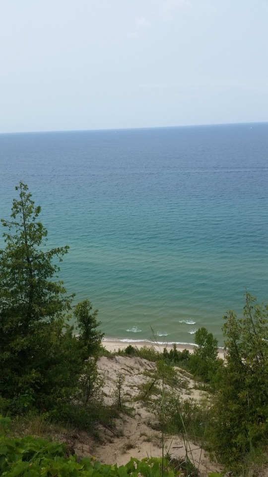
#Lake Michigan has spectacular sand bluffs
Text
The off-kilter pictures (one literally).
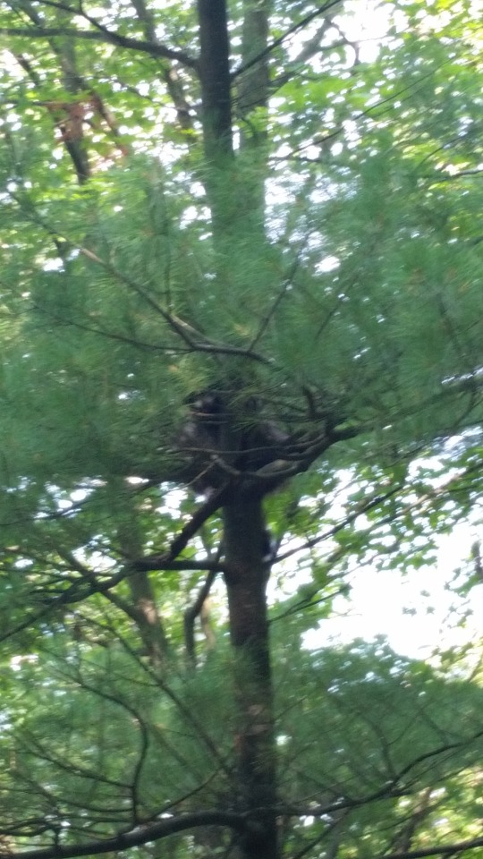
#spot the hidden observer#(there was actually a better angle 10 feet down the trail 😂)#(but the phone was already stashed and the pack was up)#(this one is more fun anyway)#(probably would never have noticed him if some folks coming the other way hadn't mentioned it)#(I was thoroughly wiped at that point)#(having just done some distance in loose sand)#(and then elevating above it)#and trying to capture the elevation#higher *above* the water than horizontally from it#Lake Michigan has spectacular sand bluffs#and not just the famous ones at Sleeping Bear#my pictures
2 notes
·
View notes
Text
Explore 10 stunning natural wonders in United states
You don't have to travel far in the United States to find stunning natural beauty, but some places are simply magical. The country has a land area of approximately 3.8 million square miles, so it should come as no surprise that it has some spectacular scenery so it's time to get your US visa now!
Arches National Park
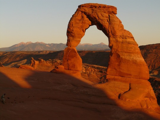
Arches National Park has the highest density of natural stone arches in the world, with over 2,000 natural stone arches. The park is located in eastern Utah, right next to the Colorado River, and most visitors will spend at least some of their time driving or cycling along the scenic 18-mile road that winds through the park.
Black Canyon of Gunnison
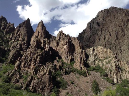
The Black Canyon of Gunnison, natural wonders of the united states, carved out by the Gunnison River over two million years, contains some of North America's steepest and most majestic cliffs and rock spires. Hiking trails suitable for most ages and abilities can be found along the canyon's north and south rims, and those in peak physical condition may be tempted to try one of the extremely strenuous trails that lead down into the inner canyon.
Caddo Lake
Caddo Lake, which straddles the border between Texas and Louisiana, is a great place to boat, fish, canoe, and hunt for geocaches. The lake contains over 70 different species of fish, and canoes and fishing equipment are available for rent in the park. There's plenty to keep visitors entertained for days, and overnight accommodations include 46 campsites and several historical cabins.
Crater lake
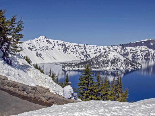
Crater Lake, located in south-central Oregon, was formed approximately 7,700 years ago by the collapse of a large volcano. The lake is entirely fed by rain and snow, making it one of the cleanest bodies of water on the planet. It is the deepest lake in the United States and the third deepest in the world.
Denali National Park
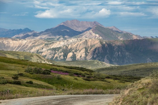
Denali National Park is best known for being the home of North America's tallest mountain, Denali Peak (20,310 feet). The first known ascent of the mountain occurred in 1913, and the difficult peak has since drawn mountaineers from all over the world. All climbers must register with the Denali National Park and Preserve at least 60 days before attempting the ascent.
Sleeping Bear Dunes National Lakeshore
This, which spans a 65-mile stretch of Lake Michigan's coastline, is best natural wonders in USA for its massive sand dunes perched 400 feet above the lake. Visitors can head up to the sandy bluffs for excellent views of Lake Michigan, admire the views from the seat of a canoe on one of the many inland lakes.
Everglades National Park

Covers 1.5 million acres of wetland on Florida's southern tip, and is made up of mangrove forests, sawgrass marshes, and pine flatwoods. The endangered leatherback turtle and the West Indian manatee are among the many species of flora and fauna found here. The park is accessible via Miami, Everglades City, or Homestead, and park permits can be purchased at any of the three entrances.
The Garden of the Gods
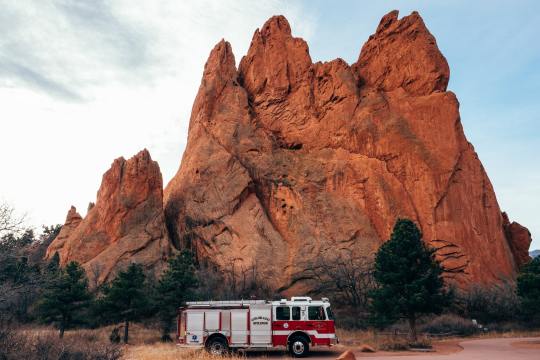
Located in the heart of Colorado Springs, has been designated as a National Natural Landmark since 1971. The park has more than 15 miles of hiking, cycling, and horseback riding trails, including a 1.5-mile paved trail that runs through the park's heart. Other popular activities here include technical rock climbing, Segway or Jeep tours..
Glacier National Park in Montana
Also known as the "Crown of the Continent," is the source of streams that flow all the way to the Gulf of Mexico. No trip to the park is complete without a drive down the Going-to-the-Sun road, which connects the park's east and west sides, but there are also over 700 miles of trails for visitors to enjoy. It is one of the best natural attractions in USA.
The Grand Canyon
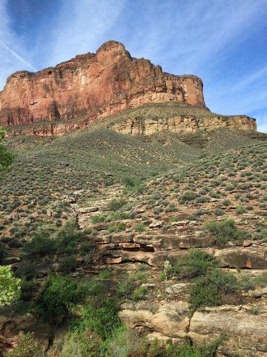
It is easily one of the most famous landmark in the USA; stretching 277 miles through the Arizona desert, the colorful canyon is a true natural wonder with numerous recreational opportunities. There are three rims to the canyon: the South Rim, the North Rim, and the West Rim.
1 note
·
View note
Text
7 of the Best Hiking Trails in Door County

Allegiances have shifted in the world of recreational activities. Thanks largely to increasing health awareness, an average American is more into outdoor fun. People are getting interested in hiking, trekking, boating, birding, etc… Thrill seekers find gratification in adventure sport such as rock climbing, snorkeling, horsing, around and more. Geocaching is becoming popular, courtesy of easily accessible technology. Inarguably, Door County is a perfect destination for all such forms of recreational activities.
Furthermore, it houses some of the amazing parks, which has excellent hiking trails. The viewpoints on offer are something to treasure. It doesn’t get any better than watching Lake Michigan from a bluff. The local residents are regular park visitors and they are super friendly with tourists. In this post, we will be focusing exclusively on hiking in Door County. We will talk about the parks, hiking trails, and bluffs, which are characteristic of this region. Here we present the top 9 hiking trails in Door County.
All trails at Peninsula State Park (Hemlock, Lone Pipe tail, Minnehaha & the Vita Course) When you are in Door Country, it would be criminal to miss this one. The park offers a range of recreational activities for the families. When it comes to hiking, you got a rocky trail ahead. It often intersects with the banks of Lake Michigan. Not just the flora, the fauna offers to treat you grand. Birders will love the trails especially when they have a liking for woodpeckers. The woods are striking with tall trees. There are some relaxing hikes so close to the lake. The sound of water hitting the shore is music to the ears.
Not just the hiking, there's history too. There is an early 1800s lighthouse at the park. Additionally, it has an amazing golf course build in 1921. It is, in fact, the only golf course in Wisconsin state park system. It doesn't just end there. There's Eagle panorama which offers an entire view of the Green Bay. The Nicole beach is a beautiful place for people to visit. Its Hemlock trail, Lone Pipe tail, Minnehaha trail, and Vita Course trail forms an all-around circuit.
Eagle Trail, Peninsula State Park
There’s no way you can afford to miss the Eagle Trail. It is located in Peninsula State Park too. Eagle Bluff and Eagle Bluff Lighthouse are its main attractions. Since the trail travels along the coastline, you can enjoy a spectacular beach view. You are in for a challenging hike nonetheless.
It's a 2-mile loop with remarkable 150-foot cliffs. There are several steep rocky sections which any rock climber would love to visit. The strenuous uneven surface is woven with loose rock and tree roots. It's heavily traveled and feels congested for trail running in peak seasons.
Hotz Loop, Newport State Park
Newport State Park has miles and miles of hiking opportunity. In its headquarters, you can get the brochure explaining the history of the park. The Hotz loop is the most popular hiking trail in it. Running 7 miles, it is indeed the longest too. Deciduous and coniferous trees make up for the ambient setting. The tree canopy forms tunnels of pure vegetation. It goes all the way till Rolling Hills which separate Europe Lake and Lake Michigan. The trail to the boathouse on Europe Lake is built with rocks in step stone type fashion. Thordarson Trail, Rock Island State Park Being one of the most remote spots in the county, Rock Island State Park offers amazing hiking and backpacking opportunity. It takes a ferry to get to the Rock Island. Mostly everybody is on foot, considering the park authorities don’t welcome bikes or cars. The grand boathouse will get your attention immediately. Thordarson trail runs the entire circumference of the island (5.2 miles). It is named after Chester Thordarson who owned the island till 1964. You will come across some of the popular attractions in this trail including Pottawatomie Lighthouse, the oldest lighthouse of the state.
Tower Trail, Potawatomi State Park
It is located at the southern end of Door County. The locals consider it the gateway of Door County. Established in 1928, it houses 123 campsites. Some of them have electrical hookups and even a shower building. Tower trail is the most preferred hike to take. It leads to the observation tower located at the highest bluff in Potawatomi State Park. Parking and restrooms are available at the old tower site. The trail loops through the park before going through the
campground. It's a great spot for picnic or group camping too. There are multiple group camping sites in the park.
Ice Age Trail, Potawatomi State Park
The eastern trailhead of the 1000 mile Ice Age Trail is located in Potawatomi State Park. It goes through 2.8 miles of shoreline at the park. It’s close to the observation tower. The trail exits the park through Shoreline Road to Sturgeon Bay. You can feast on the view of Green Bay. You can come across multiple picnic areas. It is a perfectly functional hiking trail with adequate parking, vault toilet, and water facilities.
Whitefish Dunes State Park Trails (Black trail & Red trail)
It is one of the five Door County state parks. There are over a mile and half of beatific Michigan Lake sand beach. Its Nature Center documents the formation of dunes and Native American history spanning 12,000 years. Its adjacent observation point offers a spectacular view of the beach. The combined 8-mile double loop of the Black trail and Red trail goes through the woods. To our surprise, the trails are open all year round and it always gives an easy, scenic hike. You will love its rocky exposure. The park is popular for its winter trails too. Moreover, it houses the tallest sand dune of Wisconsin.

Make sure you know where it is deep enough! The lake levels vary from year to year.
Black Trail, Cave Point County Park
This is not a national or state park. Nevertheless, it offers nothing short of an amazing hike. County officials maintain this park in top class conditions. The admission is free to spectacular views of the beach, picnic areas and importantly, hiking trails. The Black trail connects Cave Point County Park and Whitefish Dunes State Park. The hike explores the quieter sections across the coastline. The sights at Cave Point shoreline are eye-pleasing. Wild shrubs and flowers make up the forest floor. You might come across bucks, porcupines and other wildlife. It makes for a fun spot to jump in the water when it is calm too.
Ellison Bluff County Park
This county park is located in the northern part of Door Peninsula. It was established in 1951 when the county bought 88 acres in this region, to preserve and protect. A bunch of people came together to buy and add another 86 more acres to create this 174-acre park. That sums up the park’s history. It houses a moderately trafficked 1.5-mile trail – Ellison Bluff Loop. With its striking forest settings, it’s great for all skill levels. It’s best used during May to October. The green floor of interior forest bursts with white and pink trillium and other wildflowers.

Have you seen the crazy tree?
About Door County
Door County is a 150-year-old county in the state of Wisconsin. It houses more than 30,000 residents. Tourists who love recreational activities, involving nature’s splendid landscapes visit this place. Residents of Wisconsin and Illinois hugely constitute up the tourist fraternity. The county gets its name from Death’s door, the strait between the Door Peninsula and Washington Island. It has a centuries-old history involving French settlements and Native Americans.
Read the full article
0 notes
Text
Nine things I know about flying in Wisconsin
A beautiful state up north with a serious aviation addiction
Wisconsin is my adopted summer home state and the place where I do most of my fun flying. No, I’m not crazy; I head to Florida when snow, cold temps and ice fishing become the norm. Returning just before Memorial Day allows me the advantage of enjoying the best of both worlds. I like to say that I live in paradise… but in two widely disparate states. Flying makes the commute easy.
1. Wisconsin is more than cows, deer, corn…
Beyond wintry weather, most folks unfamiliar with Wisconsin likely think it’s filled with cows, deer, corn, cheese, a lot of beer, and possessed Green Bay Packers fans. Those descriptions all apply, but there is so much more Wisconsin has to offer. Its economy, ecology, geographical diversity and Midwestern values are largely underappreciated if not misunderstood. Aside from the larger cities of Milwaukee, Madison and Green Bay, Wisconsin is largely a rural state. Almost 95% of its airports are uncontrolled and only the three cities mentioned have Class C airspace over them.
2. You can divide Wisconsin into three areas
Geographically, the state can be divided into three different areas: the lowlands, the bluffs and the Lake Superior uplands. The lowlands start at the capital of Madison and extend eastward above the Illinois line to Lake Michigan and north up the shoreline to Green Bay and the stunning area of Door County. It includes the cities surrounding Lake Winnebago where Oshkosh is. The bluffs extend west from Madison and up the Mississippi River. The uplands – known locally as the Northwoods (locals say ‘nortwoods’ with a nasal twang) – is the sparsely populated recreational areas in the north. Wisconsin has 15,000 lakes and many of them are located in the northland.
3. Wisconsin takes great care of its airports
Wisconsin has many well-maintained, friendly airports for GA pilots.
Because winters can be severe, Wisconsinites have every reason to celebrate the warm months of the year in a wide variety of ways. As a result, aviators have a plethora of places to visit and opportunities to enjoy the state by air. Whatever your desires, activities abound and there’s usually an airport nearby that can service your needs. The Wisconsin DOT Bureau of Aeronautics takes its 132 airport network seriously and it shows. I know first-hand… I inhabit one. I hang out at the Wautoma airport (Y50) 35 miles due west of Oshkosh when I’m around. I like to say that if there was an airport in heaven, it would look like Wautoma. Because of its proximity to Ripon, many eastbound AirVenture airplanes stop there en route or when Oshkosh closes for any reason.
Recently talking with a main subcontractor to the State Bureau of Aeronautics, I learned that Wisconsin is one of 10 states which receive and manage block grants from the FAA Airport Improvement Program fund. As such, the federal government provides 90% of funding for new projects directly to the state, which then prioritizes needs, adds 5% while local entities provides the final 5%. I can tell you that they do a great job of helping all the airports in the state. Come see for yourself.
4. Most airports in Wisconsin are uncontrolled
Looking at a State Aeronautical chart, you have to work to find the 12 airports colored blue. Eight of those have commercial service while only three have Class C airspace above them. All of the rest are red. Owing to its rural nature, every airport has something of interest nearby, depending upon your interests.
5. Wisconsin is home of EAA
It would be heretical to not start the discussion with AirVenture. What can you say about an event that drew in 640,000 people to an airport in a town of 64,000 in 2019? While AirVenture is the pinnacle event that gets a lot of press, there’s a second side to the EAA the other 51 weeks of the year. With the crowds gone, EAA visitors can take their time in the EAA Museum. Programs abound weekly. Just this week, I attended an Aviation Adventure program with a group of F-117 Nighthawk pilots. The Poberezny estate guided tour shouldn’t be missed. EAA and FAA meet each winter in what I view as the most important give-and-take discussions involving GA. (Did you know that Harry Houdini considered nearby Appleton his home? There’s a museum at the Castle which has an exhibit dedicated to him.) 2019 was my 38th year in attendance at AirVenture and the primary reason I built my hangar nearby.
By the way, the nearby town of Iola hosts an automotive equivalent of AirVenture each summer in early July. 2019 was its 47th year – almost as long-running as AirVenture. The 300-acre Old Car Show grounds hosts about 2,500 show cars, 4,200 swap spaces, 1,000 car corral spaces and 1,600 RV campsites. If you’re a car person, you need to visit the Iola Old Car show. Get to the Iola airport four miles east and the CCF pilots will ensure you get to the show with a shuttle.
6. Wisconsin boasts the best $100 hamburger that $9 will buy at Central County Airport (68C)
Lunch at 68C is not to be missed.
Located 38nm NW of Oshkosh, this former potato field turned airport holds a Friday fly in lunch almost year around. The Central County Flyers (CCF) have a wonderful hangar filled with picnic tables and a real wood-burning fireplace where they provide lunch to “members only” (you can join for life for $10.) People fly in from hundreds of miles away to enjoy the aviation camaraderie, good food and airplane watching every week. A few years ago, it was renamed Paul Johns Field to honor a local resident/pilot who flew Boeing 314 Clippers on 221 crossings of the Pacific during WWII. This airport is a joy to behold; this is how GA ought to be everywhere. Its Friday fly in lunch menu is always announced in advance online. Sadly, Paul Johns passed away at 104 in 2018, but a showcase filled with his mementos is in the hangar. I got to know him quite well; he started flying in 1929. I’ve seen as many as 80 airplanes on the ground on a nice weather holiday weekend. EAA folks often fly in for lunch, as well. You won’t regret putting 68C on your itinerary if you’re nearby on Friday.
7. Wisconsin is for seaplanes
As I said, Wisconsin has 15,000 lakes. There are six public seaplane bases and seven private locations where prior permission is required. There are a few restrictions on the many other lakes but most are open to use… just check the WisDOT site first. I actually have a friend who fishes from his Lake Amphibian. The lakes are where many of Wisconsin’s resorts are located.
8. Not convinced yet? Here are more of my favorite places
Baraboo-Dells airport (KDLL)
Located along a scenic section of the Wisconsin River in an area of sandstone etched gorge formations, the Wisconsin Dells is a popular resort and water park destination for mid-westerners. Enjoy old tractors … especially steam tractors? Don’t miss the Badger Steam & Gas show held in early August just after Oshkosh. Want to do some gambling? Try the Ho-Chunk Gaming casino located adjacent to the airport … they’ll come pick you up. Did you know that there’s a circus museum dedicated to preserving the sights and story of railroad based circuses in Baraboo? Their Ringlingville displays show the historic winter headquarters of that circus.
Ashland airport (KASX) and Madeline Island airport (4R5)
If you enjoy fall foliage colors or want to see the Apostle Islands National Lakeshore, autumn is the time of year to visit this area. The trip up over the Northwoods can be spectacular. Consisting of 21 islands accessible only by boat, taking the tour from Bayfield is the best way to see the islands and the six lighthouses that inhabit them. Madeline Island is not a part of the Lakeshore and is accessible via ferry or ice road once Lake Superior freezes over. In winter, you can visit the ice caves when it is determined that transiting by vehicle over the frozen lake is safe.
The Door County Peninsula above Green Bay (KSUE, 3D2 and 2P2)
Door County is a famous for its fall colors.
Door County is a peninsula jutting out of NE Wisconsin into Lake Michigan. It’s mostly a tourist/resort area and is serviced by three airports in addition to Green Bay (KGRB). In fall, this area is also a beautiful place to visit or spend a weekend. The Washington Island airport (2P2) is an especially interesting place. Just a flight around the area is breathtaking in fall. The National Railroad Museum is located in Green Bay, as is Lambeau Field near to the airport.
The Brodhead airport (C37) and EAA “Cheesehead” Chapter 431
Just before AirVenture, the EAA Chapter hosts the Hatz/Pietenpol fly in. Folks headed to Oshkosh often stop in en route. In September, they hold the Midwest Antique Airplane Club event, however, that event is open to members only. Great grass runway here.
Golfing at Wisconsin Rapids (KISW)
In the last couple of years, a new world class golf resort called Sand Valley has been built near Wisconsin Rapids. With two regulation courses, Sand Valley (named best new course in 2017) and Mammoth Dunes (named best new course in 2018) plus a 17 hole par three course named The Sand Box – the airport has been inundated with high-end jet traffic bringing serious golfers to the area. The airport manager told me this morning that last year they saw nearly 800 jets coming in. The airport has had a major runways overhaul and a new 15,000 ft sq hangar capable of hangaring G550s is under construction. If golf is your game, Wisconsin Rapids is your place. There are about 10 other courses nearby. Wisconsin Rapids is also in an area heavily covered with cranberry farming, as well.
Three Lakes Airport (40D)
If you like grass runways, a floatplane dock or a great restaurant right on the water, this is the place. The Sunset Grill is open June through Labor Day and seasonally otherwise. The restaurant is right across the street from the airport. Call ahead to make sure they’re open.
The large MOAs and restricted areas associated with Volk ANGB and Fort McCoy
Due west of Oshkosh, the Combat Readiness Training Center at Volk Field (ANG) and the nearby Fort McCoy Total Force Training Center (USA) are very active military bases often hosting major military exercises. The USAF occasionally holds safety meetings at Volk ANGB and allows civilians to fly in with prior permission (PPR). They have great static displays of airplanes. The 115th Fighter Wing flying F-16s (they’re transitioning to F-35s) from Madison’s Truax Field often uses the very large MOA and restricted airspace, as well. It’s not a good idea to transit the airspace under VFR without talking to the RAPCON on 135.25. The restricted area is a live fire area. If you have authority to enter, Fort McCoy has an absolutely wonderful Commemorative Display area of buildings and more.
9. Winters are fierce
Finally, a brief talk about pre-heating airplane engines. Owing to its extremely low winter temperatures, most airplanes based in Wisconsin spend their winters in hangars. And in those hangars, you will see every hand-built pre-heating contraption on the planet. Those that don’t have external pre-heating usually have permanently installed heaters on their engines. Include this in your planning. The EAA holds a winter ski plane fly in for a reason… extrapolate.
The post Nine things I know about flying in Wisconsin appeared first on Air Facts Journal.
from Engineering Blog https://airfactsjournal.com/2019/10/nine-things-i-know-about-flying-in-wisconsin/
0 notes
Text
Sahara-Level Sand Dunes, Mediterranean-Blue Water: Welcome to Michigan
The Dune Climb is one of the most popular things to do in a remarkably beautiful, off-the-radar corner of northwest Michigan called Sleeping Bear Dunes National Lakeshore. Yet it had me suffering like a modern-day Sisyphus on a June afternoon. With each oxygen-sucking, uphill step, I slipped and slid backward on the sandy slope. My lungs burned, my bad knee ached, I was drenched with sweat — and I was only halfway to the top.
For locals, the sandy clamber is a childhood rite of passage. “Our mom would take us there to tire us out,” a friend told me, “while she lounged in her beach chair and drank Tab.”
And on this day, kids galloped past me and rolled down the 300-foot dune, their squeals as high-pitched as the cries of the herring gulls overhead. For visitors like me, the steep climb was a way to dig into the park’s quintessential feature: sand.
The park has a plethora of the stuff, from 35 miles of beaches to “perched dunes” towering 450 feet above Lake Michigan — part of the state’s 275,000 acres of sand dunes, which help make up the largest freshwater dune system in the world.
Under a blazing morning sun, I forged upward, thinking — possibly hallucinating — about a cool drink and a dive into the lake, which, I’ve been promised, is two miles across the sand. I could have been in Dubai’s desert; this certainly looks like no landscape I saw growing up in Middle America. Elsewhere in the 71,000-acre park, pristine beaches and bone-white lighthouses call to mind Maine. And all of it curves along the third-largest of the great lakes, as deep-blue and sparkling as the Mediterranean Sea.
For all the park’s odd, otherworldly beauty, it can be reached year-round via a short flight from Chicago (In summer, there are direct flights from several major airports). Yet, like many lifelong Midwesterners, I’d never heard of it until a few years back, when it garnered headlines after “Good Morning America” viewers voted it Most Beautiful Place in America.
Even as I triumphantly crested the top of the dune, it was difficult to imagine that such an extraordinary place existed here. I was pleased to find the view didn’t disappoint. Behind me stretched a forest canopy, rolling wooded hills, farmland and the iridescent waters of sprawling Glen Lake.
And just ahead (after a bit more hiking), Lake Michigan appeared in the distance, shimmering like a mirage, delicious enough to drink. Stretching west, so vast and sapphire blue, the lake seemed endless as an ocean, stopping only when its farthest edge met the pale sky — two shades of blue colliding to form the distant horizon.
Even locals don’t grow immune to the beauty; many keep an annual park-entrance pass dangling from their car’s rearview mirror for spontaneous after-work outings (a less-expensive weekly pass is $25). “We chase the sunset,” Emily Betz Tyra, a native of the region and editor of Traverse Magazine, told me, “and everyone has their favorite beach.”
The following day, ignoring a gray sky, I set out to find my own private stretch of sand. I had arrived at an awkward time, in early June, when the weather can require a tank top one day and a down jacket the next. The actor Tim Allen, who has long summered in this part of northern Michigan, famously compared its climate to “ripe pears — really good for a short period of time.”
Like me, he’s among those who think that, on a sunny summer day, the area looks more like the Mediterranean than modest Michigan. “If you get there between the Fourth of July and late August, in a stretch where it’s 90 degrees, and you’re standing on a white sand beach — you’d be hard-pressed to tell me where you were, if you didn’t know,” the actor told Forbes magazine.
Weather is a subject much on the minds of locals these days. Lake Michigan’s water levels reached near record highs this year (after hitting an all-time low in 2013). Past decades have seen the lake’s water levels wax and wane with the vagaries of rain, snow and climatic conditions; for now, with great swaths of sand underwater, the park’s beaches are “much narrower” than in 2018, more than one person said. Sleeping Bear Dunes’ deputy superintendent, Tom Ulrich, put it this way: “You can still play Frisbee on the beach; you just have to be a lot more accurate.”
I was speaking to Mr. Ulrich at the Sleeping Bear Dunes visitors center in Empire, population, 375, a Rockwellian hamlet smack-dab in the middle of the park. Antique stores and ice cream shops populate the one-stoplight town’s Front Street, while Carol Cunningham’s baked-goods stand runs on the honor system from her front yard. (Just drop your coins in and snag one of her popular cherry scones.)
From there, I drove to nearby Esch Beach, following a gravel road through a pristine woodland, windows open. I could almost hear the ghosts of Aral, a logging boom town here in the late 1800s that all but disappeared once the timber was gone, around 1930. On impulse, I stopped and cut the motor; only the symphony of birdsong filled my ears. Drinking in the fresh air, I felt intoxicated. By the time I got to the nearly deserted beach, I was in full Zen mode.
On this day, Lake Michigan was painted in a moody palette of grays and silvers, with a straight dark line at the overcast horizon. With no wind, the water was as smooth as glass and crystal-clear, its sandy bottom peppered with stones rounded by endless waves. I crouched by the water’s edge and listened to the quiet, which was broken only by the gentle lapping of water on sand, as soothing as any sound machine.
Less gentle was the frigid water, which wouldn’t warm to swimsuit-worthy temperatures until July. I waded in to my knees, feeling my calves turn numb as a pro athlete’s in an ice bath. A more appealing way to enjoy the lake appeared when three standup paddle boarders glided by, silent as swans. Surfers, too, can be seen catching waves year round, and you can rent a board or take a lesson through the friendly Sleeping Bear Surf & Kayak shop in Empire.
I ambled down the beach to where a couple and two young children scavenged for Petoskey stones (Michigan’s state stone) — fossils beautifully laced with a honeycomb pattern, relics from when warm seas and coral reefs covered this region 350 million years ago.
“Find any?” I asked.
The father shook his head, while his impatient wife — a Nebraska native — had given up, deeming the treasure “an urban legend,” Lake Michigan’s version of the Loch Ness monster. (Local stores hawking the stones, polished to a high sheen and often made into jewelry, would disagree.)
As a lakeshore overseen at the federal level, with the same protections as a national park, Sleeping Bear Dunes’ beaches are blissfully free of snack bars, jungle gyms, life guard chairs and other trappings of civilization. They’re in their natural state, these long expanses of sand. And amid the 35 miles of coastline, it’s easy enough to find a deserted strand where you’re free to do as you please — up to a point: A sign along Esch Beach warns sun worshipers to KEEP YOUR SWIMSUIT ON. (A portion of the beach was once popular among nudists.)
Curious about Sleeping Bear Dunes’ history, I learned that some 14,000 years ago, retreating glaciers carved out Lake Michigan and left behind ridges and glacial moraines (headlands of rock and dirt). Westerly winds blowing across the lake piled sand atop the moraines, creating the spectacularly steep and tall dunes — known as perched dunes — that define the park. Following the retreat of the glaciers, Anishinabek Indians were active here when Europeans arrived in the mid-1600s, and some of the 100 miles of hiking trails trace well-worn paths the Indians followed across the dunes to reach their fishing camps.
The park also maintains villages that thrived in the late 19th century: Port Oneida, a lumbering and farming community, and Glen Haven, a port town along an expansive beach where steamers stopped seeking food, lodging and wood for fuel. You can step back a century or so by meandering through their preserved buildings, including a fruit cannery (now a boat museum), general store and blacksmith shop.
There’s another way to enjoy the coastline and the lake: from up high. The easy, 1.5-mile Empire Bluff Trail led me through a beech-maple forest to a lofty bluff above Lake Michigan, where I gaped at one of the prettiest views in all of the park, north along the lake’s dune-draped shoreline. A more challenging hike took me huffing and puffing to the top of a steep headland known as Pyramid Point (a popular launching point for hang gliders and paragliders). But standing there, nearly straight above the lake, the only airborne things I saw were herring gulls coasting below me on the breeze.
Happily, there’s a way to see dramatic vistas without a hike that feels like a cardiac stress test: Pierce Stocking Scenic Drive, a seven-mile blacktop road that leads cars and cyclists through the wooded hills and towering dunes. (It’s an especially lovely route when the leaves turn in fall.)
Numbered stops show off spectacular views, and the highlight is Stop 9, which boasts a wooden platform perched precariously atop a fiercely angled dune, some 450 feet above the water. It’s surely the most Instagrammed spot in the park — and perhaps the best place in the entire Midwest to watch the sunset, slowly melting into Lake Michigan.
It’s certainly not true that if you’ve seen one sunset you’ve seen them all, but I confess I spent as much time on the viewing structure looking down — at folks racing to the bottom of the dune, then plodding back up. Those at the water’s edge looked like mere specks from my perspective — and had clearly ignored the sign that warned: “Running down may sound fun. Trust us: Climbing up 450 feet of hot sand and gravel definitely is not.” Some learn the hard way: Last year, park rangers rescued 17 souls too tired, sick or scared to make their way back to the top.
Climbing a dune is like walking up a down escalator, as many sand-savvy folks have noted, including the Pulitzer Prize-winning author Annie Dillard. But Mr. Ulrich, the park’s deputy superintendent, appreciates the impulse. “Anyone who visits Sleeping Bear Dunes,” he concedes, “should go home with a little sand in their shoes.” Back home from my trip a few days later, I readied my hiking socks for the wash and unleashed a small avalanche onto the floor.
Lucinda Hahn, a Chicago area native, is a freelance writer who lived on a dune overlooking Lake Michigan for two years while she was the editor of Lake magazine.
Sahred From Source link Travel
from WordPress http://bit.ly/2UveJVA
via IFTTT
0 notes
Last Seen Blogs

rosemaryonthehearth
Welcome to the Hearth

anime-html
Anime Html

desirefound
desirefound - a multimuse!

simsxtiffy
Long time simmer and content creator

ryonello
this is an apex legends appreciation blog