#Oracle APEX GoogleMaps FacetedSearch
Explore tagged Tumblr posts
Visit Tumblr Blog
Explore Tumblr blogs with no restrictions, modern design and the best experience.
Last Seen Tumblr Blogs


Fun Fact
In Q3 of 2020, 31% of US users access the Tumblr app daily.
Text
Oracle APEX: Making Google Maps respond to Faceted Search
“One of my work projects elicited the need to have a map that responded to changing search criteria. I thought it would be a great opportunity to mix APEX’s new Faceted Search feature with Google Maps. I’ll try to walk you through how I accomplished it. [Disclaimer: you’ll need an API Key from Google in order to render the maps.]
The APEX Faceted Search feature was introduced with version 19.2. Out-of-the-box, you can have a region for your search criteria (i.e. facets) and another region, a report, that refreshes automatically to reflect the new search filters. Carsten Czarski wrote a blog post showing how you can have multiple regions (charts, reports, etc.) react to changes to the faceted search. I used his approach, with some tweaks, in combination with the Google Maps JavaScript APIs.
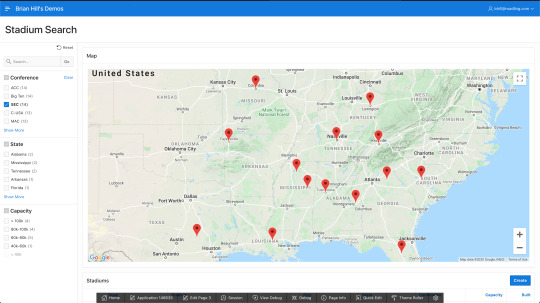
The simplified (silly) use-case here is a list of NCAA (FBS) college football stadiums. With the faceted search, you can filter a report region by conference, state, and seating capacity. There is also a Google Map with a marker for each matching stadium. You can try it out here:
https://apex.oracle.com/pls/apex/bhill_roadling/r/blog3/blog-stadiums-search
I am limiting the number of times the Google Map can be rendered because there is a cost associated with it. Here are some screen shots in case we’ve hit our quota or the page doesn’t work for some other reason:

First, you’ll need a data set - I got mine from here. I loaded it into a table called BLOG_STADIUMS, which is defined as:
CREATE TABLE "BLOG_STADIUMS" ( "ID" NUMBER GENERATED ALWAYS AS IDENTITY MINVALUE 1 MAXVALUE 9999999999999999999999999999 INCREMENT BY 1 START WITH 1 CACHE 20 NOORDER NOCYCLE NOKEEP NOSCALE NOT NULL ENABLE, "STADIUM" VARCHAR2(255), "CITY" VARCHAR2(50), "STATE" VARCHAR2(50), "TEAM" VARCHAR2(255), "CONFERENCE" VARCHAR2(50), "BUILT" NUMBER, "DIV" VARCHAR2(50), "LATITUDE" NUMBER, "LONGITUDE" NUMBER, "CAPACITY" NUMBER, "EXPANDED" NUMBER, PRIMARY KEY ("ID") USING INDEX ENABLE ) /
Then I created a new APEX app which automatically built the Faceted Search page. For more info on how to build one from scratch, see this post by Carsten Czarski. I tweaked the facets a bit to match the screen shots above. At this point, I have everything but the Google Map, and it was very easy to get this far.
Here’s the outline for getting the filtered data into Google Maps:
Retrieve the filtered data set
Format it with JSON
Use an an Ajax Callback process to retrieve the JSON data
Use JavaScript to parse the JSON and call the Google APIs to render the map
Use a Dynamic Action to refresh the map when the facets change
Retrieve the Filtered Data Set:
Per Carsten’s blog post (the one I referenced first), we create a new type in the database for a single row of the result set:
CREATE OR REPLACE EDITIONABLE TYPE "TYP_STADIUM_ROW" as object (id NUMBER, stadium VARCHAR2(255), city VARCHAR2(50), state VARCHAR2(50), team VARCHAR2(255), conference VARCHAR2(50), built NUMBER, div VARCHAR2(50), latitude NUMBER, longitude NUMBER, capacity NUMBER, expanded NUMBER ) /
Then we create another new type as a table of that object:
CREATE OR REPLACE EDITIONABLE TYPE "TYP_STADIUM_TABLE" as table of typ_stadium_row /
Then we create a pipelined function to get the filtered result set from our search results report region:
create or replace FUNCTION fn_get_stadium_search_data(p_page_id IN NUMBER, p_region_static_id IN VARCHAR2) RETURN typ_stadium_table PIPELINED IS l_region_id NUMBER; l_context apex_exec.t_context; TYPE t_col_index IS TABLE OF PLS_INTEGER INDEX BY VARCHAR2(255); l_col_index t_col_index; --------------------------------------------------------------------------- PROCEDURE get_column_indexes(p_columns wwv_flow_t_varchar2 ) IS BEGIN FOR i IN 1 .. p_columns.COUNT LOOP l_col_index(p_columns(i)) := apex_exec.get_column_position(p_context => l_context, p_column_name => p_columns(i)); END LOOP; END get_column_indexes; --------------------------------------------------------------------------- BEGIN -- 1. get the region ID of the Faceted Search region SELECT region_id INTO l_region_id FROM apex_application_page_regions WHERE application_id = v('APP_ID') AND page_id = p_page_id AND static_id = p_region_static_id; -- 2. Get a cursor (apex_exec.t_context) for the current region data l_context := apex_region.open_query_context(p_page_id => p_page_id, p_region_id => l_region_id ); get_column_indexes(wwv_flow_t_varchar2('ID', 'STADIUM', 'CITY', 'STATE', 'TEAM', 'CONFERENCE', 'BUILT', 'DIV', 'LATITUDE', 'LONGITUDE', 'CAPACITY', 'EXPANDED')); WHILE apex_exec.next_row(p_context => l_context) LOOP PIPE ROW(typ_stadium_row(apex_exec.get_number (p_context => l_context, p_column_idx => l_col_index('ID' )), apex_exec.get_varchar2(p_context => l_context, p_column_idx => l_col_index('STADIUM' )), apex_exec.get_varchar2(p_context => l_context, p_column_idx => l_col_index('CITY' )), apex_exec.get_varchar2(p_context => l_context, p_column_idx => l_col_index('STATE' )), apex_exec.get_varchar2(p_context => l_context, p_column_idx => l_col_index('TEAM' )), apex_exec.get_varchar2(p_context => l_context, p_column_idx => l_col_index('CONFERENCE')), apex_exec.get_number (p_context => l_context, p_column_idx => l_col_index('BUILT' )), apex_exec.get_varchar2(p_context => l_context, p_column_idx => l_col_index('DIV' )), apex_exec.get_number (p_context => l_context, p_column_idx => l_col_index('LATITUDE' )), apex_exec.get_number (p_context => l_context, p_column_idx => l_col_index('LONGITUDE' )), apex_exec.get_number (p_context => l_context, p_column_idx => l_col_index('CAPACITY' )), apex_exec.get_number (p_context => l_context, p_column_idx => l_col_index('EXPANDED' )) ) ); END LOOP; apex_exec.close(l_context); RETURN; EXCEPTION WHEN NO_DATA_FOUND THEN apex_exec.close(l_context); RETURN; WHEN OTHERS THEN apex_exec.close( l_context ); RAISE; END fn_get_stadium_search_data; /
The function has 2 parameters: 1 for the APEX page number and 1 for the region’s static ID. My faceted search is page 3, and I set the static ID of my search results region to “searchResults”. The function uses APEX_REGION and APEX_EXEC to get the individual values from the report region, then assembles them into a collection of the type we built above.
At this point, we could create a new chart region in our APEX page that queries this pipelined function instead of our BLOG_STADIUMS table. A query would look something like this:
SELECT id, stadium, city, state, team, conference, built, div, latitude, longitude, capacity, expanded FROM table(fn_get_stadium_search_data('3', 'searchResults'))
Format it with JSON:
In order to use the data with Google Maps, we need to format it with JSON. Something like this will work:
{"map_boundaries": {"center_latitude": 30.61009758, "center_longitude": -96.34072923, "east_longitude": -96.34072923, "north_latitude": 30.61009758, "south_latitude": 30.61009758, "west_longitude": -96.34072923 }, "stadium_data": [{"built": "1927", "capacity": "102,733", "city": "College Station", "color": null, "conference": "SEC", "div": "fbs", "expanded": "2015", "id": "00004", "latitude": 30.61009758, "longitude": -96.34072923, "stadium": "Kyle Field", "state": "Texas", "team": "Texas A&M" }, {"built": "1924", "capacity": "100,119", "city": "Austin", "color": null, "conference": "Big 12", "div": "fbs", "expanded": "2009", "id": "00008", "latitude": 30.2836034, "longitude": -97.73233652, "stadium": "Darrell K Royal–Texas Memorial Stadium", "state": "Texas", "team": "Texas" } ] }
Notice that the JSON contains “map_boundaries” data. We’ll use that data to (1) determine where to center the map, and (2) calculate a zoom level.
Here’s the code for a function that will build that:
create or replace FUNCTION fn_get_stadium_data_json RETURN CLOB IS l_json_data CLOB; CURSOR c_stadiums IS WITH stadiums_cte AS (SELECT id, stadium, city, state, team, conference, built, div, latitude, longitude, capacity, expanded FROM table(fn_get_stadium_search_data('3', 'searchResults')) ) SELECT JSON_OBJECT('map_boundaries' VALUE (SELECT JSON_OBJECT('west_longitude' VALUE min_lon, 'east_longitude' VALUE max_lon, 'south_latitude' VALUE min_lat, 'north_latitude' VALUE max_lat, 'center_latitude' VALUE NVL((min_lat + max_lat) / 2, 39.8333), 'center_longitude' VALUE NVL((min_lon + max_lon) / 2, -98.5833) RETURNING CLOB) FROM (SELECT LEAST( MIN(latitude), 90) AS min_lat, LEAST( MIN(longitude), 180) AS min_lon, GREATEST(MAX(latitude), 0) AS max_lat, GREATEST(MAX(longitude), -180) AS max_lon FROM stadiums_cte ) ), 'stadium_data' VALUE (SELECT JSON_ARRAYAGG(JSON_OBJECT('id' VALUE TO_CHAR(id, 'FM00000'), 'stadium' VALUE stadium, 'city' VALUE city, 'state' VALUE state, 'team' VALUE team, 'conference' VALUE conference, 'built' VALUE TO_CHAR(built, 'FM0000'), 'div' VALUE div, 'latitude' VALUE latitude, 'longitude' VALUE longitude, 'capacity' VALUE TO_CHAR(capacity, 'FM999G990'), 'expanded' VALUE TO_CHAR(expanded, 'FM9990'), 'color' VALUE CAST(NULL AS VARCHAR2(12)) RETURNING CLOB) RETURNING CLOB) FROM stadiums_cte ) RETURNING CLOB) AS json_stadium_data FROM dual; BEGIN --============================================================================================================================ -- Get all of the stadium data and put it in a PL/SQL collection. --============================================================================================================================ OPEN c_stadiums; FETCH c_stadiums INTO l_json_data; CLOSE c_stadiums; RETURN(l_json_data); END fn_get_stadium_data_json; /
Notice that it calls the other function we built. I’m sure the SQL could be simpler, but it works.
Ajax Callback Process to Retrieve JSON:
On page 3 of my APEX app, I created an Ajax Callback process with these properties:

The name is “refreshMap” and it wraps our previous function with “htp.p”.
Use JS to Parse the JSON and Call the Google Map APIs:
Now that we have the data formatted with JSON, and we have a way to retrieve it via JS, we just need to do that and use the APIs to render the Google Map. We’ll declare a JS function called “initMap” that will use the APEX JS API “apex.server.process” to execute the Ajax Callback Process we created above. When the callback is successful, we’ll execute some JS to calculate an appropriate zoom level for the map, and then we’ll call google.maps.Map to render it. Finally, we’ll loop through the JSON data and create a marker for each stadium. I added some code to display a little info window when the mouse hovers over a marker. [The info window works pretty well on Safari, but seems real twitchy in Chrome. I’ll post any fixes I come up with.]
Here’s the code for the “Function and Global Variable Declaration” page property:
function initMap() { apex.server.process('refreshMap', // Process or AJAX Callback name {}, // No page items to pass/set {success: function (pData) {// Success Javascript var data = pData; //.substring(1, pData.length - 3); var json_data = JSON.parse(data); var GLOBE_WIDTH = 256; // a constant in Google's map projection // Calculate Zoom level based upon longitudes var pixelWidth = $("#map").width(); var west = json_data.map_boundaries.west_longitude; var east = json_data.map_boundaries.east_longitude; var angle1 = east - west; if (angle1 < 0) {angle1 += 360;} var zoom1 = Math.floor(Math.log(pixelWidth * 360 / angle1 / GLOBE_WIDTH) / Math.LN2); // Calculate Zoom level based upon latitudes var pixelHeight = $("#map").height(); var south = json_data.map_boundaries.south_latitude; var north = json_data.map_boundaries.north_latitude; var angle2 = north - south + 3; var zoom2 = Math.floor(Math.log(pixelHeight * 360 / angle2 / GLOBE_WIDTH) / Math.LN2); // Choose the lower of the 2 Zoom levels var zoom = Math.min(zoom1, zoom2); // If the zoom is calculated to infinity, then set it to 4. This will occur when no stadiums are found. if (zoom === Infinity) {zoom = 4;} var map = new google.maps.Map(document.getElementById('map'), { zoom: zoom, center: {lat: json_data.map_boundaries.center_latitude, lng: json_data.map_boundaries.center_longitude }, mapTypeId: 'terrain', mapTypeControl: false, streetViewControl: false } ); var myLatLng; var marker; var infoWindow = new google.maps.InfoWindow(); $.each(json_data.stadium_data, function(index, element) { myLatLng = {lat: element.latitude, lng: element.longitude}; marker = new google.maps.Marker( {position: myLatLng, map: map, title: element.stadium }); // Open the InfoWindow on mouseover: google.maps.event.addListener(marker, 'mouseover', function(e) { infoWindow.setPosition(e.latLng); infoWindow.setContent("<table class=\"infoContent\"><tr>" + "<td class=\"infoContentLabel\">Team: </td>" + "<td class=\"infoContentData\">" + element.team + "</td>" + "</tr><tr>" + "<td class=\"infoContentLabel\">Stadium: </td>" + "<td class=\"infoContentData\">" + element.stadium + "</td>"+ "</tr><tr>"+ "<td class=\"infoContentLabel\">Location: </td>"+ "<td class=\"infoContentData\">" + element.city + ", " + element.state + "</td>" + "</tr><tr>"+ "<td class=\"infoContentLabel\">Capacity: </td>"+ "<td class=\"infoContentData\">" + element.capacity + "</td>" + "</tr><tr>"+ "<td class=\"infoContentLabel\">Built: </td>"+ "<td class=\"infoContentData\">" + element.built + "</td>" + "</tr></table>"); infoWindow.open(map); }); // Close the InfoWindow on mouseout: google.maps.event.addListener(marker, 'mouseout', function() { infoWindow.close(); }); }); }, dataType: "text" // Response type (here: plain text) } ); }
Now we need to load the Google Maps API JS and provide them with an API key. To do this, we add this JS code to the “Execute When Page Loads” page property:
(function(d, script) { script = d.createElement('script'); script.type = 'text/javascript'; script.async = true; script.onload = function(){ // remote script has loaded }; script.src = 'https://maps.googleapis.com/maps/api/js?key=<yourKeyHere>&callback=initMap'; d.getElementsByTagName('body')[0].appendChild(script); }(document));
And finally, I added this to the “Inline” CSS page property:
/* Always set the map height explicitly to define the size of the div * element that contains the map. */ #map { height: 600px; } .infoContentLabel { font-weight: bold; }
Dynamic Action to Refresh the Map
The last step is to get the map to refresh dynamically when the facets change. Create a new Dynamic Action named “When Search Changes” that fires on the “After Refresh” event for the search results region (the name is “Stadiums”, the static ID is “searchResults”). It has one TRUE action - Execute JavaScript Code with the following code:
initMap(); //setTimeout(function(){ initMap(); }, 750);
Note: The “Facets Change” event seemed to cause a race condition between the map region and the search results region. Sometimes it would show the latest info, sometimes it wouldn’t. I was able to use a JS timeout of about .75 seconds to work-around that, but I found that just refreshing the map after the refresh of the search results worked better.
0 notes