#PointCloudModeling
Explore tagged Tumblr posts
Visit Tumblr Blog
Explore Tumblr blogs with no restrictions, modern design and the best experience.
Last Seen Tumblr Blogs


Fun Fact
Tumblr has 4 main sources of revenue.
Photo

Every environment, whether spontaneous or fully cultivated, has an aesthetic character that is expressed in its landscape forms and interstitial spaces. Staging perspective experience within such variegated contexts involves developing spatial relationships of views such as panoramas, cityscape, punctures or sightlines. Point cloud modelling extends the imagination of spatial relationships between existing and new elements beyond pictorial techniques like the diorama. (Model by CHAN Chuen Yan, SOON Ian Wen)
Journal of Landscape Architecture, Open Access: https://doi.org/10.1080/18626033.2022.2110422
#journal#topography#digitalmodeling#pointcloudmodeling#design#methodology#landscape#lidar#morphology#science#EthZurich
2 notes
·
View notes
Link
Looking for Point Cloud Modeling services in US, Uk, Canada, Sweden? Your search ends here. Cresire offers the best Point cloud to 3D model services at an affordable price. We take the scanned data from you and help you with Point Cloud Modeling. Scan to BIM Services is quite useful for renovation projects. For more details, email us today at [email protected] or visit https://bit.ly/3fU5bz2
#pointcloudmodeling#pointcloudtobim#pointcloudtobimmodeling#pointcloudtobimmodelingservices#scantobimmodelingservices#scantobimmodeling#scantobim#pointcloudtomodelservices#pointcloudtomodel#pointcloudto3dmodelservices#pointcloudto3dmodel#pointcloudtorevitmodeling#pointcloudtorevit#bimscan#usa#uk#canada#australia#sweden#norway#newzealand#uae#germany#austria#france#india
0 notes
Link
0 notes
Photo

Silicon Valley Infomedia Ltd - www.siliconinfo.com offers quality point cloud to #BIM services which is second to none, giving you an assortment of #CAD Engineering and including the master Point Cloud BIM services. There are fewer organizations that are giving the #PointCloud BIM Service and we are glad to be one of those organizations.
For more info: Website: https://bit.ly/399OvOv Inquiry: https://bit.ly/2GXWr9o Contact: + 44-208-819-5832 / + 1 - 763-270-8285
0 notes
Link
#PointCloudBIMservices#Pointclouddata#Pointcloudmodeling#Pointcloudmodel#Pointcloudmodelingservice#Pointcloudrendering
0 notes
Text
Point Cloud to BIM - A Helping Hand in Restoring Historic Buildings
Point Cloud to BIM is a revolutionary method for the construction industry as far as the restoration of historic structures goes. The reconstruction of historic structures using laser scanning data not only enables a new level of design workflow as well as coordination and communication between all project stakeholders but is also quick and precise.
Read more here:- https://www.teslaoutsourcingservices.com/blog/point-cloud-to-bim-a-helping-hand-in-restoring-historic-buildings/
#pointclouddata #laserscans #laserscanningdata #pointcloudtobim #scantobim #pointcloudmodelling #pointcloudtobimservices #refurbishment #renovation #infrastructure #teslaoutsourcingservices

0 notes
Photo

#Buildingscan or surface scan in construction is a non-destructive reality capture technique. #TejjyInc. has expertise in facilitating scan to BIM services for design build firms, AEC professionals, contractors and surveyors.To Know More: https://www.tejjy.com/our-services/bim-3d-model/scan-to-bim/#PointCloudModeling #BIM #3DLaserScanning
0 notes
Photo

Three shaping actions with point cloud modelling can support the development of a site-specific design: forming, placing and staging. These topographic shaping actions together constitute a design method that can help designers to interact with the natural and human-made elements of the landscape and to invent numerous possibilities for spatial arrangements.
Journal of Landscape Architecture, Open Access: https://doi.org/10.1080/18626033.2022.2110422
#journal#topography#digitalmodeling#pointcloudmodeling#design#methodology#landscape#lidar#morphology#science#EthZurich
1 note
·
View note
Photo

Looking for #3DScanningServices? We @ Silicon Valley Infomedia Ltd - www.siliconinfo.com try to pass on better than anything appealing results for every client we work with.
For more info: Website: https://bit.ly/2U581HH Inquiry: https://bit.ly/2Gty1Ev Contact: + 91-79-2685-2558 / +1 (763) 270-8285
0 notes
Link
#PointCloudBIMservices#Pointcloudmodeling#Pointcloudmodel#Pointcloudmodelingservice#Pointcloudprocessingservices
0 notes
Photo

Excerpt (without citations): "Point cloud modeling is a process of selectively manipulating the geometry of 3D point cloud models. The manipulation is deduced from existing spatio-visual configurations and induces creative and functional intentions to develop new design scenarios. This manipulation involves digital processing techniques such as classification and segmentation, allowing to cut, filter and disassemble the geometry."
Ref: https://doi.org/10.1016/j.compenvurbsys.2021.101731
#definition#pointcloudmodeling#urbandesign#urbanlandscape#sutdsingapore#fclsingapore#designstudio#simulation#EthZurich
0 notes
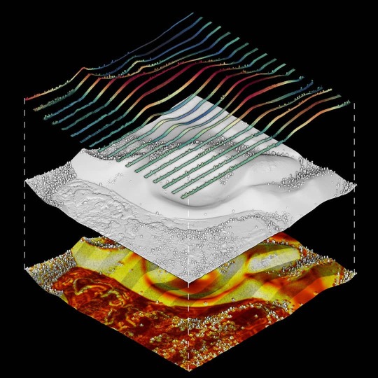
Photo

Reassembly of a point cloud model to test the spatial and visual impact of the design in the context. The vertical distance is calculated to distinguish and retain only the existing points of the laser-scanned terrain, indicated in light grey, and the new points of the modified terrain, indicated in color (a). New buildings and new plants distributed individually are assembled with the unchanged context. Values stored as scalar fields, such as the point source of individual components, here indicated in random colors, and values of Leaf Area Density, are integrated into the reassembled model (b). Synthetic points are organized to match the form and data structure of the original point cloud model, such as the classification (c).
In: Urech, Philipp R. W., Maria Angela Dissegna, Christophe Girot, and Adrienne Grêt-Regamey. “Point Cloud Modeling as a Bridge between Landscape Design and Planning.” Landscape and Urban Planning 203 (2020): 103903. https://doi.org/10.1016/j.landurbplan.2020.103903.
#survey#topography#pointcloudmodeling#landscapedesign#pointcloud#als#designmethod#urbandesign#architecture#EthZurich
0 notes
Photo

Rearrangement of the vegetation in a point cloud model according to a new terrain. Laser-scanned vegetation points (a) are normalized by substracting the elevation of the terrain from adjacient points (b). The points can then be modeled on a new topography either by adjusting their elevation values (c) or by using a library of individual laser-scanned models to populate the terrain surface (d).
In: Urech, Philipp R. W., Maria Angela Dissegna, Christophe Girot, and Adrienne Grêt-Regamey. “Point Cloud Modeling as a Bridge between Landscape Design and Planning.” Landscape and Urban Planning 203 (2020): 103903. https://doi.org/10.1016/j.landurbplan.2020.103903.
#survey#topography#pointcloudmodeling#landscapedesign#pointcloud#als#designmethod#urbandesign#architecture#EthZurich
0 notes
Photo

The disassembly of a point cloud model allows us to differentiate between preserved and transformed parts during the design process. Classification software helps to separate ground points from land cover points, which are further separated in vegetation and building points using a classifier trained with machine learning (a). Connected components labelling is used to separate individual elements, here indicated in random colors, for selective removal and to build an object library (b). Significant features of the terrain are identified and extracted based on the surface orientation of ground points ©.
In: Urech, Philipp R. W., Maria Angela Dissegna, Christophe Girot, and Adrienne Grêt-Regamey. “Point Cloud Modeling as a Bridge between Landscape Design and Planning.” Landscape and Urban Planning 203 (2020): 103903. https://doi.org/10.1016/j.landurbplan.2020.103903.
#survey#topography#pointcloudmodeling#landscapedesign#pointcloud#als#designmethod#urbandesign#architecture#EthZurich
0 notes
Photo
The point cloud model shows a geological feature at the Bonito lava flow near the Sunset Crater Volcano National Monument. The Sunset Crater (not shown in this model) is a 305 meters tall cinder cone that erupted sometime around 1085 CE. Normals calculated on the point geometry highlight the slope of the terrain.
The Lidar was collected for the National Park Service for inventory and monitoring of Sunset Crater Volcano’s unique resources. The objective of this procurement was to acquire a high-resolution bare-earth digital elevation models of the park with an accuracy ranging from 0.15 meter to 0.50 meter.
Source: Open Topography https://doi.org/10.5069/G9K0726C 3D model: https://skfb.ly/6UoVn
0 notes
Photo

Change detection between laser-scanned and modified point cloud models. A point cloud model from aerial laserscanned data, colored by elevation 3–40 m AMSL, shows a 3 m-wide canal (white line) aligned to the former railway (top left). The point cloud model is manipulated to improve the capacity of water catchment, shown with the same height gradient (top right). The design maintains the original depth of the canal and height of the railway, both colored in white in the topographic change comparison (bottom left). The comparison shows how existing features can be retained locally during the design process, while changes occur in less-significant parts.
In: Urech. 2020. Editing Cumulated Landscapes: Point Cloud Modeling as a Method of Analysis in Landscape Design. https://doi.org/10.17645/up.v5i2.2885
#survey#topography#pointcloudmodeling#landscapedesign#pointcloud#als#designmethod#urbandesign#architecture#EthZurich
0 notes