#Transit Oriented Development (TOD)
Explore tagged Tumblr posts
Visit Tumblr Blog
Explore Tumblr blogs with no restrictions, modern design and the best experience.
Last Seen Tumblr Blogs


Fun Fact
Tumblr’s website traffic is steadily declining.
Text

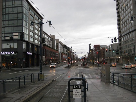
This sludgy, slippery sidewalk on Grant Street is the only pedestrian route between King Memorial Station & the apartments completed a couple of years ago as a "transit-oriented development."
Ownership is split among MARTA, Atlanta & CSX. We need those parties to cooperate.
My understanding is that the water comes from the portion that CSX owns (the ground behind the wall, which lies under their freight rail line), it seeps through the tunnel wall that MARTA owns, and lands on the sidewalk the City owns. All three entities will need to cooperate to fix it.
I'm not convinced we can truly call this a transit-oriented development until it becomes a great space for pedestrians.
14 notes
·
View notes
Text
Great Idea 19: Transit-oriented development

Transit-oriented development links transportation and land use—providing people with maximum choice in how to get around by intensifying activities near transit nodes with high quality public space. Read more.
#great ideas#new urbanism#urban design#urbanism#cities#walkability#transit#transit oriented development#development#TOD
12 notes
·
View notes
Text

Transit Oriented Development meets car dependent infrastructure. Please note, the photo is being taken from the direction of the transit station.
#urbanism#walking#pedestrian#hobo pedestrian#transit#transit oriented development#tod#trains#accessibility#cars suck
0 notes
Text
Redeveloping park-and-ride lots is a common step in mass transit planning; consensus view is that parking lot land is better used for development that can make use of the transit service on its doorstep! Maybe even better if the parking is going unused/is underutilized... (but that suggests other issues, like the transit system is not popular.) Key will be a concept that encourages less auto ownership if it's residential. Otherwise the parking can overload the adjacent neighbourhoods.
0 notes
Text
What are the barriers to TOD in America, and how can cities overcome this issue?
What are TODs?
Transit Oriented Developments are developments designed to maximize the efficiency of transit stops by increasing the density and attractions within a walkable radius of transit. These developments often feature a transit stop (train, tram, bus, etc.) surrounded by a ¼ to ½ mile circle of dense (often mixed use) commercial, places of employment, and public spaces. Outside of the inner circle, there is also an outer circle of increasingly less dense residential as you move further away from the stop.
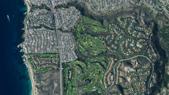
"Transit-Oriented Development at 4th and King Caltrain Station - Mission Bay San Francisco" by neighborhoods.org is licensed under CC BY-SA 2.0.
Barriers
One of the most common barriers for implementing TOD in American cities is the high presence of NIMBY (Not in My Backyard) residents that protest these types of developments. NIMBY’s are often residents that have deeper involvement in the community and shoot down proposals that would bring more housing to their neighborhood. This is the case for many Transit Oriented Developments, as these projects often bring dense, larger scale housing to neighborhoods. In the case of NIMBY’s, the most common form of pushback is that the large scale of development will ruin the “character” of the neighborhood. In many cases, NIMBY’s have lots of pull in terms of influencing city council members and have the power to drastically alter or cancel TOD projects all together.
However, NIMBYs are only half of the issue when getting TOD projects completed, often car-oriented infrastructure, and the design of US cities poses a massive barrier to TOD projects. The main component of TOD is the transit itself, which it often runs on its own right of way separate from cars. However, cars still too often play a part in terms of TOD projects and can reduce the efficiency of the transit line/housing built. The most obvious impedance is that the majority of residential developments built still must adhere to car-oriented housing and zoning codes. Car centric suburbs continue to be the most prominent and mass-produced style of housing. This lack of density severely limits the effectiveness of public transit, gutting the walkability and bikeability of these neighborhoods and limiting the access to transit stops.

"An American suburb" by futureatlas.com is licensed under CC BY 2.0.
Solutions
While many of these barriers provide significant challenges for Transit Oriented Developments in the United States, there are ways to successfully get around them, the first being zoning higher density around transit stops. High-density developments around the central transit stop are one of the defining aspects of a successful TOD and are key to making them more accessible to residents in the area. The more people you have living, working, and shopping within walking or biking distance from the stop, means the more people can use it with relative ease. On top of this, using a street layout more conducive to walkability would also decrease the barriers to creating a successful transit-oriented development. By getting rid of the pedestrian-limiting cul-de-sacs in favor of a street network that provides multiple routes & intersections to the transit stop (the gridiron is a good example), we can create a more accessible and efficient TOD area.
Finally, while working around the NIMBYS is an option in some cases (often with consequences later down the line). These kinds of conflicts are best resolved by working with the community to dispel misconceptions and create a mutually beneficial outcome. By recognizing the community's concerns and creating policies and amenities to meet them (like working to limit gentrification, a common concern), you can often reach a much stronger and more effective resolution to this barrier.
Example
A great example of usage of TOD can be found around the subway stations in Paris, France. Built in 1900, the subway provides access to 1.5-2 million jobs by mass rapid public transit within 30 minutes. Paris distributes it’s subway stations in concentric successive circles with the most density accommodated in the first 5-kilometer radius circle. Job densities show a similar density within the first 3 kilometers of the radius and then decline with distance. The stations are also often located near various indoor malls, shopping centers, and tourist attractions which allow for easy access to more than just places of employment. By building the subways in a manner that allows access to so many jobs and other things in France, as well as having the train run so frequently, the Paris subway stations are without a doubt a great example of transit-oriented development.

"Paris Subway Sign" by sri_the_quack is licensed under CC BY-SA 2.0.
1 note
·
View note
Text
URBAN SPRAWL
Urban Sprawl is the uncontrolled expansion of urban areas into surrounding rural or natural areas. It's leading to low-density development, increased car dependence, and environmental consequences such as habitat loss and air pollution. It often results in inefficient land use, strain on infrastructure, and social issues like increased commuting times and the decline of central city areas. Understanding urban sprawl involves considering its impact on transportation, environment, and community development, which can inform strategies for more sustainable urban planning and growth management.
This phenomenon is often characterized by low-density development, reliance on automobiles for transportation, and the fragmentation of natural habitats. Urban sprawl can lead to a variety of negative consequences, including increased traffic congestion, air and water pollution, loss of agricultural land, and decreased quality of life for residents.
Transit-Oriented Development (TOD) is a concept that has gained significant traction in urban planning and design in recent years. It is a multifaceted approach to urban development that centers around creating vibrant, livable, and sustainable communities with a strong emphasis on public transportation and walkability.
At its core, TOD seeks to create compact, mixed-use, and pedestrian-friendly neighborhoods that are centered around high-quality public transportation systems, such as buses, subways, light rail, or commuter rail. The aim is to reduce reliance on private automobiles and promote more sustainable modes of transportation, thereby mitigating traffic congestion, reducing air pollution, and fostering a more connected and environmentally friendly urban environment.
Key principles of Transit-Oriented Development include:
Proximity to Transit: TOD emphasizes the development of residential, commercial, and recreational spaces within close proximity to transit stations or stops, typically within a half-mile radius. This encourages residents and workers to use public transportation for their daily commutes and errands.
Mixed-Use Development: TOD promotes a mix of land uses, including residential, commercial, retail, and recreational spaces within the same neighborhood. This diversity of land uses encourages a vibrant and dynamic urban environment, reduces the need for long commutes, and fosters a sense of community.
Pedestrian-Friendly Design: TOD places a strong emphasis on creating walkable neighborhoods with well-designed sidewalks, pedestrian pathways, and public spaces. This encourages active transportation, enhances the overall quality of life, and promotes social interaction.
High-Density, Compact Development: TOD often involves higher-density development, including mid-rise and high-rise buildings, to maximize land use efficiency and support a critical mass of residents and workers near transit nodes.
Sustainable Design and Environmental Considerations: TOD prioritizes sustainable design practices, such as energy-efficient buildings, green spaces, and stormwater management, to minimize environmental impact and promote resilience.
Overall, Transit-Oriented Development represents a holistic approach to urban planning and design, aiming to create vibrant, accessible, and sustainable communities that are well-integrated with public transportation infrastructure. By fostering a seamless connection between land use and transportation, TOD has the potential to reduce car dependency, enhance mobility, and create more livable urban environments.
Sonetra KETH (កេត សុនេត្រា) Architectural Manager/Project Manager/BIM Director RMIT University Vietnam + Institute of Technology of Cambodia
#TOD#Sonetra Keth#NETRA#នេត្រា#Urban Sprawl#Urbanism#Urban Design Principle#Architectural Manager#Project Manager#Real Estate Developer#Transit-Oriented Development#<meta name=“google-adsense-account” content=“ca-pub-9430617320114361”>#crossorigin=“anonymous”></script>#<script async src=“https://pagead2.googlesyndication.com/pagead/js/adsbygoogle.js?client=ca-pub-9430617320114361”#<meta name=“monetag” content=“07e99e76c61091cfc8c3590b90f57e37”>
0 notes
Text
Urban Design Concept of the Day
Transit Oriented Development

TOD is when developments and construction are designed to be served by transit, this is done by making an area Walkable and centered around a transit station. It also frequently includes mixed use zoning so that people can shop and eat near the station. Basically when you get off a metro stop, there should immediately be shops, housing and restaurants right there. This is important as it makes transit more usable and the housing around it better to live in
200 notes
·
View notes
Text
Housing is a queer issue
what's the number one reason someone has to stay somewhere unsafe? Can't afford to live somewhere else.
Queer folks are more likely to experience homelessness, trans folks even more so. And that's likely to set off a cascade of consequences with issues getting a job, accessing health care, and so on.
Wherever you live, show up for Planning & Zoning meetings or write a letter when they're considering higher density housing and especially if they're considering zone changes like Transit Oriented Development (TOD). Those aren't just for big cities!
Show up and say "Yes, I want Those People to live HERE".
Yes, In My Back Yard.
Say yes to infill especially where existing in-town lots with access to services are rezoned to higher density units. The new apartments should go where the sewer line already is, not where it requires running a whole new spur and where everyone is isolated and requires a car to get everywhere.
Say yes to that public housing in the downtown core where people can WALK to all the services they need.
Everyone should have access to safe affordable housing. You won't know who exactly you're helping, but you're helping tear down a barrier for everyone.
26 notes
·
View notes
Text
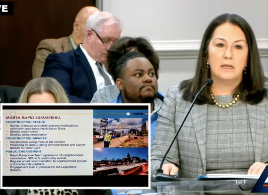
In a presentation to Atlanta City Council's transportation committee this week, MARTA representative Carrie Rocha (Chief Capital Officer) gave a report on several projects...
Summerhill Bus Rapid Transit (BRT) construction has been hampered by various unforeseen difficulties including the presence of a previously-unknown underground parking deck(!). It's possible the opening of that service may be pushed into 2026.
The projected cost of Campbellton Road BRT is now $319 million, with a completion date of 2030. They've already spent $8 million on it. Apparently there are some difficulties with the bike lanes included in the plan and adjustments may need to be made.
Relatedly, Councilmember Jason Dozier asked Rocha about the potential for a transit oriented development (TOD) at Oakland City Station and Rocha replied that they are working with the mayor's office to prioritize a TOD at that station, to connect with the Campbellton Road BRT line.
Rocha also implied that planning for the Clifton Corridor BRT is on hold while MARTA studies the feasibility of a heavy-rail infill station at Armour Yards, since that (potential) station could be a more logical connection point than Lindbergh Station.
Also, Cleveland/Metropolitan Arterial Rapid Transit (ART, an enhanced bus service though not quite BRT) is not expected to be complete until 2028. Meanwhile on MARTA's web page for Cleveland Avenue and Metropolitan Parkway ART, it still says: "Current Status: Final design near completion. Construction expected to begin in Fall 2023 with service beginning in early 2025." Oops. Might want to update that.
You can watch the full meeting here:
https://youtube.com/watch?v=8v-zT5BszGs
2 notes
·
View notes
Text
How M3M Jewel Leverages Transit-Oriented Development to Boost Commercial ROI
Regarding investing in commercial properties, the location is not just about the headquarters-it is well connected. This is where the development of transit (TOD) comes. The M3M Jewel, a leading commercial project in Gurgaon, sets a new standard by integrating TOD into its design and strategy. But what does this mean for you as an investor or company owner?

What is the development of transit (TOD)?
TOD is a modern approach of urban planning, which focuses on building commercial and residential areas around efficient public transport systems. To put it simply, TOD projects are:
Near metro stations, highways and bus routes
Pedestrian
Designed to minimize travel time for customers and employees
Why should you be interested? Since commercial space-based commercial spaces attract more tracks, they offer higher rental revenues and provide long-term stability value-critical factors for strong investment (ROI).
Strategic location on a transit grid
The M3M Jewel Gurgaon is located on the MG Road and Golf Course Extension, one of the liveliest courses in Gurgaon. Here is what gives him a clear advantage of this:
The proximity of the MG Road Metro station - less than 2 minutes
Direct access to NH-48-Bezoblým connection to Delhi and Jaipur
Surrounded by residential areas with high-density-three commuting areas in the river basin area
This strategic location at sector 25 ensures easy availability that is the main asset for any commercial property. Whether you run a retail store, office or food court, easy access is reflected in more business.
More commuting means more footfall means more business opportunities
In today's real estate market, it is not enough to simply build commercial space and hope for the best. The key is to be where people are already. By finding a high -transmission zone, it knocks on daily traffic from commuting, locals, visitors and tourists.
Here is how it benefits commercial investors:
Retailers get a consistent trail from metro passengers and nearby office workers
Cafe and restaurant will become comfortable stops for commuting
Office spaces become very attractive for businesses that prefer ease of commuting for their employees
Shortening Commute Time Lengthens Dwell Time
One of the most important advantages of Transit-Oriented Development (TOD) that tends to go unnoticed is longer dwell time—the duration for which people stay at a place. M3M Jewel makes the most of this by providing not only convenient access but also:
Comfortable walking areas
Organized open spaces
A combination of commercial uses (retail, restaurants, and office space)
When individuals have the ease of access to an area and staying for longer, they spend more money, thereby immediately increasing commercial tenants' profitability. It's a two-way benefit for customers and property owners.
Future-Proofing with Smart Urban Planning
Gurgaon is fast transforming into a smart city, and TOD takes center stage. M3M Jewel is already future-proof by:
Being designed to support Gurgaon's Master Plan 2031
Capitalizing on future metro expansion and highway upgradation that will further enhance accessibility
Surrounded by high-density residential neighborhoods that ensure sustained demand
As transport options in TOD areas increase and traffic in other areas grows due to congestion, properties such as M3M Jewel will get even more preferred, leading to greater capital appreciation and rental yield.
Conclusion
An investment in M3M Jewel MG Road is not merely buying commercial space—it's being part of a future-focused environment where location, accessibility, and intelligent design converge to deliver sustainable returns and growth.
In a bustling city like Gurgaon, where time equals money and convenience is paramount, the transit-first concept of M3M Jewel places it heavily ahead in the rat-race of commercial real estate.
#commercial property#m3m jewel#m3mgurgaon#m3mproperties#gurgaonproperties#m3m india#realestate#architecture
1 note
·
View note
Text
Houston’s Real Estate Growth Near New Transit Lines.

Houston’s ongoing investment in public transportation is reshaping the city’s real estate landscape. The expansion of transit lines, including light rail and bus rapid transit (BRT) systems, is enhancing connectivity and spurring significant development in adjacent neighborhoods.
Impact of METRORail Expansion on Property Values
The METRORail system’s growth has notably influenced property values along its routes. Improved accessibility and reduced commute times have made areas near transit stations more desirable, leading to increased residential and commercial property values. Studies indicate that proximity to light rail stations can have significant positive effects on residential property values.
Transit-Oriented Development (TOD) Initiatives
Houston has embraced transit-oriented development (TOD) to create walkable, mixed-use communities centered around transit hubs. The Tidwell Transit Center, for example, has an action plan to enhance mobility and connectivity through TOD. Similarly, the Gulfton neighborhood is set to transform with a $1.2 million federal grant aimed at developing a transit-oriented community hub.
Neighborhood Transformations and Community Impact
The introduction of new transit lines has led to notable neighborhood changes. For instance, the METRONext Moving Forward Plan includes 500 miles of travel improvements, aiming to enhance mobility across the Houston region. These developments have sparked discussions about balancing growth with community preservation and affordability.
Future Outlook
As Houston expand its transit infrastructure, the real estate market is poised for further evolution. The METRONext Moving Forward Plan, approved by voters in 2019, includes significant investments in light rail and BRT expansions. These projects are expected to create new opportunities for development and potentially increase property values in areas adjacent to new transit lines.
In summary, Houston’s commitment to enhancing its public transportation network is not only improving urban mobility but also driving substantial growth and transformation in the real estate sector. For investors, developers, and residents, staying informed about these transit developments is crucial for making strategic decisions in Houston’s dynamic real estate market
Thinking about buying or selling? Let’s make it happen!
📍 Tili Capistran — Your Houston & Conroe Real Estate Expert 📞 713–875–3715 | 📩 [email protected]
#TalkToTili #UnderContract #ConroeTX #HoustonRealEstate #SoldByTili #TexasHomes #DreamHome
0 notes
Text
Real Estate Consulting Company in Bangalore
When it comes to real estate development, various factors determine the scope and scale of a construction project. One of the most crucial factors is Floor Space Index (FSI), also known as Floor Area Ratio (FAR). Understanding FSI is essential for developers, investors, and homeowners to ensure compliance with regulations and optimize space utilization. In this blog, we will delve deep into what is FSI in real estate, its significance, calculation, and its impact on property development. We will also explore how a Real Estate Consulting Company in Bangalore can assist in understanding and implementing FSI regulations effectively.
What Is FSI in Real Estate?
FSI, or Floor Space Index, is the ratio of the total built-up area of a building to the total plot area on which it is constructed. It is a regulatory measure used by urban planning authorities to control the density of construction in a given area. The primary objective of FSI is to maintain a balance between infrastructure, open spaces, and population density.
To put it simply, what is FSI in real estate? It is a guideline that dictates how much construction is permissible on a given plot of land. For instance, if a plot has an FSI of 2.0, it means that the total built-up area can be twice the size of the land area.
A Real Estate Consulting Company in Bangalore can provide in-depth insights and guidance regarding FSI norms, ensuring that developers adhere to regulations while maximizing the utility of their land.
How Is FSI Calculated?
The calculation of FSI is straightforward. The formula is:
For example, if a plot has an area of 1,000 square meters and the permissible FSI is 2.0, then the total built-up area allowed would be:
square meters.
Different cities and zones have varying FSI limits depending on factors such as road width, infrastructure, and urban planning norms. Consulting a Real Estate Consulting Company in Bangalore can help developers determine the applicable FSI and plan their projects accordingly.
Types of FSI
1. Basic FSI
This is the standard FSI allowed for a particular zone without any additional premiums or charges.
2. Premium FSI
Developers can avail extra FSI by paying a premium to the governing authorities, subject to specific conditions.
3. TDR-Based FSI
Transfer of Development Rights (TDR) allows developers to obtain additional FSI by acquiring development rights from other landowners or authorities.
4. Special FSI
Some locations, such as transit-oriented developments (TODs), may have special FSI provisions to encourage high-density development near transport hubs.
Importance of FSI in Real Estate
1. Regulates Urban Development
What is FSI in real estate controls the density of construction in a given area, preventing overcrowding and maintaining infrastructural balance.
2. Impacts Property Valuation
Higher FSI can increase property value as it allows more built-up area, making it an attractive investment opportunity.
3. Ensures Sustainable Growth
Urban planning authorities use FSI regulations to ensure balanced growth, optimizing resources and public amenities.
4. Influences Design and Construction
Architects and developers must consider FSI while designing projects to comply with legal norms and maximize space efficiency.
Factors Affecting FSI
1. Location and Zone Regulations
FSI varies depending on whether the property is in a commercial, residential, or industrial zone.
2. Road Width
Wider roads often allow higher FSI as they can accommodate increased population density and infrastructure needs.
3. Type of Construction
High-rise buildings generally require higher FSI, whereas low-density housing developments have lower FSI limits.
4. Government Policies
Local and national policies influence FSI regulations, with periodic revisions based on urban development strategies.
A Real Estate Consulting Company in Bangalore can assist developers in navigating these factors to optimize their projects within the regulatory framework.
How to Optimize FSI for Real Estate Projects?
Maximizing FSI efficiently requires careful planning. Here are some strategies:
Understand Local Zoning Laws: Ensure compliance with municipal regulations.
Utilize TDR: Purchase additional FSI through TDR for larger developments.
Leverage Premium FSI: Consider paying a premium for extra buildable area.
Incorporate Smart Design: Use vertical expansion and space-saving designs.
Work with Experts: A Real Estate Consulting Company in Bangalore can help navigate legal and technical aspects.
Consulting with a Real Estate Consulting Company in Bangalore ensures that real estate projects comply with FSI norms while achieving maximum efficiency.
How a Real Estate Consulting Company in Bangalore Can Help
Understanding what is FSI in real estate and its implications can be complex, especially with varying local regulations. A Real Estate Consulting Company in Bangalore provides expert guidance on:
FSI Regulations: Advising on permissible FSI based on location and zoning laws.
Project Feasibility: Analyzing the impact of FSI on project viability and returns.
Legal Compliance: Ensuring that projects adhere to building codes and approval processes.
Optimization Strategies: Helping developers maximize land utilization while maintaining regulatory compliance.
By consulting with a Real Estate Consulting Company in Bangalore, developers can make informed decisions, ensuring compliance with regulations while maximizing profitability.
Whether you are a builder, investor, or homebuyer, knowledge of FSI helps in making strategic real estate investments. If you are planning a real estate project in Bangalore, partnering with industry experts ensures a smooth and profitable journey.
Conclusion
FSI is a critical aspect of real estate development that impacts project feasibility, valuation, and sustainability. Understanding what is FSI in real estate is essential for developers, investors, and homeowners looking to make informed decisions. Collaborating with a Real Estate Consulting Company in Bangalore ensures that projects comply with FSI regulations while optimizing space and profitability. Whether you are planning a residential or commercial project, professional consultation can help streamline the process, making your real estate venture a success
0 notes
Text
Development Sites: Prime Real Estate Opportunities in Jersey City
Jersey City is experiencing rapid growth, making it an attractive location for investors and developers seeking development sites for commercial, residential, and mixed-use projects. Strategic planning and the right location can lead to high returns on investment.
Why Invest in Development Sites in Jersey City?
1. Prime Location & Connectivity
Jersey City’s proximity to New York City, along with excellent transportation infrastructure, makes it a highly desirable area for new developments.
2. Strong Economic Growth
The city’s booming job market, rising population, and business-friendly policies support long-term investment in development sites.
3. Diverse Investment Opportunities
Residential Developments – High demand for luxury condos, apartments, and affordable housing.
Commercial Properties – Office buildings, retail centers, and coworking spaces.
Mixed-Use Developments – Combining residential, commercial, and recreational spaces.
4. Tax Incentives & Zoning Benefits
Jersey City offers various incentives for developers, including tax abatements and rezoning opportunities, encouraging growth in underutilized areas.
Key Trends in Jersey City Development Sites
1. Waterfront Redevelopment
The waterfront continues to be a hotspot for high-end residential and commercial projects, attracting investors and businesses.
2. Transit-Oriented Developments (TODs)
Areas near PATH stations and transit hubs are in high demand for mixed-use and high-density developments.
3. Sustainable & Smart Building Trends
Energy-efficient buildings and smart technology are becoming priorities in modern development sites.
4. Redevelopment of Industrial Spaces
Old warehouses and industrial properties are being converted into modern office spaces, residential units, and creative hubs.
Best Locations for Development Sites in Jersey City
1. Downtown Jersey City – High-value properties and luxury developments.
2. Journal Square – Rapid urban transformation with large-scale projects.
3. The Heights – Increasing demand for residential and commercial expansion.
4. Bergen-Lafayette – Affordable development opportunities with strong growth potential.
5. Greenville – Emerging market with untapped real estate potential.
Tips for Investing in Development Sites
Conduct Market Research: Understand zoning laws, demand trends, and future growth areas.
Assess Infrastructure & Accessibility: Ensure proximity to transit, highways, and commercial hubs.
Secure Financing & Incentives: Take advantage of tax incentives and financing options for large-scale developments.
Work with Local Experts: Collaborate with experienced real estate agents, architects, and city planners for smooth project execution.
Conclusion
Investing in development sites in Jersey City offers lucrative opportunities for real estate developers and investors. With strategic planning, understanding of market trends, and a strong network, these projects can lead to long-term success.+
1 note
·
View note
Text
Real Estate Consulting Company in Bangalore
When it comes to real estate development, various factors determine the scope and scale of a construction project. One of the most crucial factors is Floor Space Index (FSI), also known as Floor Area Ratio (FAR). Understanding FSI is essential for developers, investors, and homeowners to ensure compliance with regulations and optimize space utilization. In this blog, we will delve deep into what is FSI in real estate, its significance, calculation, and its impact on property development. We will also explore how a Real Estate Consulting Company in Bangalore can assist in understanding and implementing FSI regulations effectively.
What Is FSI in Real Estate?
FSI, or Floor Space Index, is the ratio of the total built-up area of a building to the total plot area on which it is constructed. It is a regulatory measure used by urban planning authorities to control the density of construction in a given area. The primary objective of FSI is to maintain a balance between infrastructure, open spaces, and population density.
To put it simply, what is FSI in real estate? It is a guideline that dictates how much construction is permissible on a given plot of land. For instance, if a plot has an FSI of 2.0, it means that the total built-up area can be twice the size of the land area.
A Real Estate Consulting Company in Bangalore can provide in-depth insights and guidance regarding FSI norms, ensuring that developers adhere to regulations while maximizing the utility of their land.
How Is FSI Calculated?
The calculation of FSI is straightforward. The formula is:
For example, if a plot has an area of 1,000 square meters and the permissible FSI is 2.0, then the total built-up area allowed would be:
square meters.
Different cities and zones have varying FSI limits depending on factors such as road width, infrastructure, and urban planning norms. Consulting a Real Estate Consulting Company in Bangalore can help developers determine the applicable FSI and plan their projects accordingly.
Types of FSI
1. Basic FSI
This is the standard FSI allowed for a particular zone without any additional premiums or charges.
2. Premium FSI
Developers can avail extra FSI by paying a premium to the governing authorities, subject to specific conditions.
3. TDR-Based FSI
Transfer of Development Rights (TDR) allows developers to obtain additional FSI by acquiring development rights from other landowners or authorities.
4. Special FSI
Some locations, such as transit-oriented developments (TODs), may have special FSI provisions to encourage high-density development near transport hubs.
Importance of FSI in Real Estate
1. Regulates Urban Development
What is FSI in real estate controls the density of construction in a given area, preventing overcrowding and maintaining infrastructural balance.
2. Impacts Property Valuation
Higher FSI can increase property value as it allows more built-up area, making it an attractive investment opportunity.
3. Ensures Sustainable Growth
Urban planning authorities use FSI regulations to ensure balanced growth, optimizing resources and public amenities.
4. Influences Design and Construction
Architects and developers must consider FSI while designing projects to comply with legal norms and maximize space efficiency.
Factors Affecting FSI
1. Location and Zone Regulations
FSI varies depending on whether the property is in a commercial, residential, or industrial zone.
2. Road Width
Wider roads often allow higher FSI as they can accommodate increased population density and infrastructure needs.
3. Type of Construction
High-rise buildings generally require higher FSI, whereas low-density housing developments have lower FSI limits.
4. Government Policies
Local and national policies influence FSI regulations, with periodic revisions based on urban development strategies.
A Real Estate Consulting Company in Bangalore can assist developers in navigating these factors to optimize their projects within the regulatory framework.
How to Optimize FSI for Real Estate Projects?
Maximizing FSI efficiently requires careful planning. Here are some strategies:
Understand Local Zoning Laws: Ensure compliance with municipal regulations.
Utilize TDR: Purchase additional FSI through TDR for larger developments.
Leverage Premium FSI: Consider paying a premium for extra buildable area.
Incorporate Smart Design: Use vertical expansion and space-saving designs.
Work with Experts: A Real Estate Consulting Company in Bangalore can help navigate legal and technical aspects.
Consulting with a Real Estate Consulting Company in Bangalore ensures that real estate projects comply with FSI norms while achieving maximum efficiency.
How a Real Estate Consulting Company in Bangalore Can Help
Understanding what is FSI in real estate and its implications can be complex, especially with varying local regulations. A Real Estate Consulting Company in Bangalore provides expert guidance on:
FSI Regulations: Advising on permissible FSI based on location and zoning laws.
Project Feasibility: Analyzing the impact of FSI on project viability and returns.
Legal Compliance: Ensuring that projects adhere to building codes and approval processes.
Optimization Strategies: Helping developers maximize land utilization while maintaining regulatory compliance.
By consulting with a Real Estate Consulting Company in Bangalore, developers can make informed decisions, ensuring compliance with regulations while maximizing profitability.
Whether you are a builder, investor, or homebuyer, knowledge of FSI helps in making strategic real estate investments. If you are planning a real estate project in Bangalore, partnering with industry experts ensures a smooth and profitable journey.
Conclusion
FSI is a critical aspect of real estate development that impacts project feasibility, valuation, and sustainability. Understanding what is FSI in real estate is essential for developers, investors, and homeowners looking to make informed decisions. Collaborating with a Real Estate Consulting Company in Bangalore ensures that projects comply with FSI regulations while optimizing space and profitability. Whether you are planning a residential or commercial project, professional consultation can help streamline the process, making your real estate venture a success
0 notes
Text
Đấu Giá Đất Bám Dọc Tuyến Metro, TP.HCM Tính Thu Về Hàng Trăm Nghìn Tỷ Đồng
Ảnh: Vietnamfinance.vn (GNĐT) – TP.HCM đang triển khai kế hoạch đấu giá hàng loạt lô đất dọc các tuyến metro nhằm phát triển mô hình khu đô thị TOD (Transit-Oriented Development – phát triển đô thị theo định hướng giao thông công cộng). Nếu các dự án này thành công, thành phố kỳ vọng sẽ thu về nguồn ngân sách khổng lồ, lên đến hàng trăm nghìn tỷ đồng. Đây là bước đi chiến lược nhằm khai thác tối…
0 notes
Text
How Architecture Institutes in Mumbai Are Shaping Smart Cities of the Future
The concept of smart cities is transforming urban landscapes worldwide, and Mumbai is no exception. As one of India’s most dynamic metropolitan areas, the city requires architects who can design sustainable, technologically advanced, and livable urban spaces. This is where an architecture institute in Mumbai plays a pivotal role—by equipping future architects with the skills, knowledge, and innovative mindset required to shape the cities of tomorrow.

The Role of Architecture in Smart Cities
Smart cities integrate technology, sustainability, and efficient infrastructure to improve urban living. Architects play a key role in this transformation by designing eco-friendly buildings, optimizing space utilization, and incorporating smart technologies into their designs. From green buildings to AI-driven urban planning, architecture institutes in Mumbai are training students to address these modern challenges.
How Architecture Institutes in Mumbai Are Contributing to Smart City Development
1. Focus on Sustainable & Green Architecture
With rapid urbanization, sustainability has become a crucial aspect of smart city planning. Leading architecture institutes emphasize eco-friendly design principles, including:
Energy-efficient buildings with solar panels and rainwater harvesting systems Green spaces and urban forests for improved air quality Sustainable materials to reduce environmental impact
2. Integration of Smart Technology in Design
Modern architecture institutes in Mumbai train students in cutting-edge technologies like:
Building Information Modeling (BIM) for efficient planning AI-driven urban simulations for better infrastructure management Smart sensors for energy conservation and automation
By incorporating technology-driven learning, these institutes prepare students to design future-ready cities.
3. Hands-on Training & Industry Collaborations
Many architecture colleges collaborate with industry experts, urban planners, and government bodies to provide real-world exposure to students. Live projects and case studies on Mumbai’s urban challenges help students develop practical solutions for smart city development.
4. Urban Planning & Infrastructure Development
A well-planned city is at the heart of smart living. Architecture institutes focus on:
Transit-oriented development (TOD) to reduce traffic congestion Affordable housing solutions for better inclusivity Smart public spaces that enhance community interaction
TSAP: Leading the Way in Smart City Architecture
One of the leading names in architectural education, Thakur School of Architecture & Planning (TSAP) is at the forefront of smart city-focused learning. As a reputed architecture institute in Mumbai, TSAP equips students with future-ready skills in sustainable design, advanced technology integration, and urban planning. With a strong industry network, innovative curriculum, and hands-on learning approach, TSAP is shaping the next generation of architects who will redefine Mumbai’s skyline and contribute to smarter, greener, and more efficient cities.
If you're looking to be part of this transformation, TSAP is the ideal place to begin your journey in architecture!
This article is also posted on : - https://medium.com/@hardikpawar922/how-architecture-institutes-in-mumbai-are-shaping-smart-cities-of-the-future-4f5e0824515c
0 notes