#UAV Data Processing
Explore tagged Tumblr posts
Visit Tumblr Blog
Explore Tumblr blogs with no restrictions, modern design and the best experience.
Last Seen Tumblr Blogs


Fun Fact
Tumblr’s website traffic is steadily declining.
Text
Efficient UAV Data Processing Services for Actionable Insights | Geoshot Technologies
Our UAV Data Processing services offer a comprehensive solution for turning raw aerial data into actionable insights. Whether you're conducting surveys, mapping terrain, or monitoring assets, our team utilizes advanced processing techniques to extract valuable information from your data. From image stitching and orthomosaic generation to 3D modeling and analysis, we provide accurate and timely results tailored to your project needs. Partner with us to unlock the full potential of your UAV data and make informed decisions with confidence.
For more info, please email at: [email protected]
0 notes
Note
Dear Vector Prime
How did Tyran cluster's Howlback fight Bumblebee? What kind of mission was she on?

Dear Retro Reconnaissance,
Following the battle at Half Dome, Soundwave and Bumblebee clashed several more times throughout the early ‘90s. During that time, Soundwave disguised himself as a van, and was experimenting with subtler means of manipulating human minds than direct blackmail. In Detroit, together with his Pretender partner, Doombox, he infiltrated the techno scene, promoting his shows on the nascent worldwide web, and using a combination of music, psychedelics, and hypnosis to influence the behaviour of club goers. From there, he began distributing mini-cassettes to susceptible individuals with government connections, hoping to gain access to isolated federal networks. Bumblebee was able to uncover and dismantle the scheme, thanks to the help of Dairu and Zauru—but with exception of Garboil, all of Soundwave’s minions were able to escape, amongst the dozens of tapes being copied and circulated within the subculture.
Bumblebee finally settled the score with Soundwave during the Battle of Chicago, turning the tables right as the Decepticon was about to execute him. In the aftermath, the Autobots were forced back into hiding, but Bumblebee nevertheless continued to protect humanity from the shadows. While on the road, the Autobots tracked a Decepticon energy signature to Silicon Valley. There, Doombox had leveraged his Princeton connections to get in on the ground floor of a music streaming startup, and had secured a small data centre. It turned out that, before his death, Soundwave had spent years seeding the internet with viruses, tiny shell scripts that each contained some fraction of his own programming. And in a data center at the heart of the Bay Area, industrial servers were collecting and processing petabytes of concert recordings, music reviews, playlists, listening data, mashups, and the lingering consciousness of a digital ghost. Disguised as smartphones, Howlback, Buzzsaw, and Frenzy (who had escaped Seymour Simmons’ basement after the ex-agent’s rather hasty emigration to Cuba) were able to totally control the actions of the company’s founders, and Bumblebee had no way of reaching them without breaking cover. But when it became clear that they intended to turn the entire city into a new body for their master, he convinced Ratchet to help him destroy the data using an EMP blast. It was during this altercation that Howlback fought Bumblebee one-on-one, seeking revenge for Garboil, Ravage, Laserbeak, and of course Soundwave—in her UAV mode, she had him effectively pinned down, until a reckless dive-bomb brought her within reach of his new energon axe. After that, he was able to keep Frenzy and Buzzsaw busy just long enough for Ratchet to wipe the last traces of Soundwave from existence.
Alas, this brief exposure was what ultimately allowed Cemetery Wind to track down and murder Ratchet, with Lockdown’s help. As for Doombox… well, startups come and go. With access to such a heady mix of personal data, cryptocurrency, nootropics, and warm bodies, I cannot imagine he found it difficult to steal a new identity, slip into a life that was waiting for him and his cronies. Rumor has it that they are creating new life, in Silicon Valley… a form of life designed not to live on that planet, but on the next.
#ask vector prime#transformers#maccadam#live action film series#half dome#soundwave#bumblebee#detroit#pretenders#doombox#dile#zaur#garboil#chicago#silicon valley#princeton university#howlback#buzzsaw#frenzy#seymour simmons#cuba#ratchet#ravage#laserbeak#cemetery wind#lockdown#barricade643sg
25 notes
·
View notes
Text
Drone Survey in the Real World: Revolutionizing Industries with Atom Aviation
In today’s rapidly advancing world, industries across the globe are turning to drone survey technology to revolutionize the way they collect data, perform inspections, and make critical decisions. Gone are the days of traditional surveying methods that are time-consuming, costly, and labor-intensive. Atom Aviation, a leading provider of drone surveying services, is at the forefront of this transformation, providing businesses with fast, accurate, and cost-effective solutions.

What is a Drone Survey?
A drone survey is an innovative approach that utilizes unmanned aerial vehicles (UAVs) to collect data from the air. Drones equipped with cameras, LIDAR (Light Detection and Ranging), and other sensors can capture high-resolution imagery, topographical data, and 3D models of vast areas in a fraction of the time compared to traditional ground-based methods.
This data is then processed into actionable insights for industries like construction, agriculture, real estate, and more, enhancing decision-making and project planning.
The Real-World Benefits of Drone Surveys
1. Speed and Efficiency One of the main advantages of using drones for surveying is the significant reduction in time. With traditional surveying, teams would have to manually visit every corner of a site, sometimes requiring several days or even weeks for large projects. In contrast, drones can complete the same tasks in hours, allowing businesses to access crucial data quickly and make decisions faster.
2. Cost-Effectiveness Drone surveying reduces the need for expensive equipment like helicopters or cranes used in traditional aerial surveys. Additionally, fewer personnel are required to operate the drones, further lowering costs. Atom Aviation ensures that businesses can enjoy these cost savings without compromising on the accuracy or quality of the data collected.
3. High-Resolution Data Drones are equipped with high-definition cameras and specialized sensors that capture data with exceptional precision. Whether it’s topographical mapping, volumetric analysis, or landscape modeling, drones provide a level of detail that is difficult to achieve with manual methods. This is especially crucial in industries like construction, where accurate measurements are essential for project success.
4. Access to Hard-to-Reach Areas In many industries, there are locations that are difficult to access using traditional surveying methods due to safety concerns or physical barriers. Drones can easily navigate hazardous environments, such as construction sites, power lines, or agricultural fields, ensuring that no area is left unexamined.
5. Minimal Disruption Unlike ground-based surveying, which may require disturbing the environment or disrupting normal business operations, drone surveys are non-invasive. They can operate without disturbing ongoing work, making them ideal for active construction sites or agricultural fields.
How Atom Aviation is Leading the Charge
Atom Aviation is a company that has harnessed the full potential of drone surveying to offer customized solutions for businesses across various sectors. With their fleet of state-of-the-art drones and highly skilled pilots, Atom Aviation ensures that every project, no matter how large or small, is completed with precision and efficiency.
Atom Aviation’s drone surveying services have been particularly valuable in the following industries:
Construction: From land surveys to site inspections, drones help construction companies keep projects on track and ensure compliance with building codes and regulations.
Agriculture: Drone surveys allow farmers to monitor crop health, assess soil conditions, and make data-driven decisions to maximize yield.
Real Estate: Property developers and real estate professionals use drone surveys to create accurate 3D models and aerial maps of properties, helping to market developments and make informed investment decisions.
Infrastructure: Drones enable inspectors to assess bridges, powerlines, and pipelines, identifying potential issues without the need for dangerous manual inspections.
Why Choose Drone Surveying with Atom Aviation?
Choosing the right provider for drone surveying is crucial to getting accurate, reliable results. Atom Aviation stands out for several reasons:
Advanced Drone Technology: Atom Aviation uses the latest drones equipped with cutting-edge cameras and sensors for precise data collection.
Expert Team: Their team consists of certified drone pilots and experienced surveyors, ensuring that all data is collected safely and accurately.
Tailored Solutions: Whether you need topographic surveys, volumetric analysis, or 3D mapping, Atom Aviation offers services customized to meet the unique needs of your project.
Timely Delivery: With a commitment to efficiency, Atom Aviation delivers survey data quickly, enabling businesses to make decisions without delays.
Conclusion
The application of drone surveys has brought about a significant change in how businesses approach data collection and site analysis. With companies like Atom Aviation leading the way, industries now have access to faster, more cost-effective, and highly accurate surveying methods that enhance productivity and decision-making. Whether you're in construction, agriculture, real estate, or infrastructure, Atom Aviation is the partner you need for cutting-edge drone surveying solutions.
For more information on how Atom Aviation can assist with your next drone survey, visit their website today and discover how they can take your business to new heights!
Keywords Used:
Drone survey
Atom Aviation
Drone surveying services
#drone#drone survey#drone surveying#dronetober#survey#mining#AerialSurveying#DroneData#ConstructionSurveying#TopographicMapping#AtomAviation#UAVSurvey#3DMapping#LandSurveying#RemoteSensing
2 notes
·
View notes
Text

Dutch MQ-9 Reapers drones start surveillance operations on NATO's eastern flank
Fernando Valduga By Fernando Valduga 25/01/2024 - 14:00in Military, UAV - UAV
The Dutch Ministry of Defense announced the deployment of MQ-9 drones to strengthen NATO's surveillance capabilities along its eastern flank. The first two MQ-9 aircraft arrived in Romania two nights ago, with the final drone expected to arrive soon.
These unmanned vehicles will collect crucial information along the eastern NATO border, operating from the Romanian Air Base in Campia Turzii. These drones mark a significant step in the contribution of the Netherlands to NATO's security efforts.

Dutch military engineers are currently establishing a base camp on site to facilitate deployment. The control and operation of these unmanned aircraft will be carried out remotely from Vliegbasis Leeuwarden, in the Netherlands, where the collected data will also be processed.
The MQ-9 drones are prepared to conduct land and sea operations. This detachment not only improves the independent intelligence capabilities of the Netherlands, but also allows the sharing of critical information with NATO allies. This is particularly vital for the defense of the alliance's border areas.

Previously parked in Curaçao for training and anti-drug operations, these Reapers accumulated more than 2,800 hours of flight around the island. They have been instrumental in the preparation of Dutch Air Force personnel and have now been transported to Romania for their new mission.
Tags: Military AviationDronesMQ-9 ReaperNATO - North Atlantic Treaty OrganizationRNLAF - Royal Netherlands Air Force / Royal Dutch Air Force
Sharing
tweet
Fernando Valduga
Fernando Valduga
Aviation photographer and pilot since 1992, he has participated in several events and air operations, such as Cruzex, AirVenture, Dayton Airshow and FIDAE. He has works published in specialized aviation magazines in Brazil and abroad. He uses Canon equipment during his photographic work in the world of aviation.
Related news
AERONAUTICAL ACCIDENTS
VIDEO: Turkish aircraft C-160 makes emergency landing
25/01/2024 - 12:45
MILITARY
End of an Era: USAF trains the last pilot instructors of F-15 Eagle jets
25/01/2024 - 11:30
AERONAUTICAL ACCIDENTS
Russia's fall of Il-76 generates speculation between Ukrainians and Russians
25/01/2024 - 09:03
BRAZILIAN AIR FORCE
FAB intensifies actions in the Amazon region with Operation Catrimani
25/01/2024 - 08:16
MILITARY
IMAGES: USAF presents F-16 jets with special tails that celebrate the 50th anniversary of the iconic fighter
24/01/2024 - 21:58
INTERCEPTIONS
Japan sent its fighters 555 times in the last 9 months for interception missions
24/01/2024 - 20:13
4 notes
·
View notes
Text
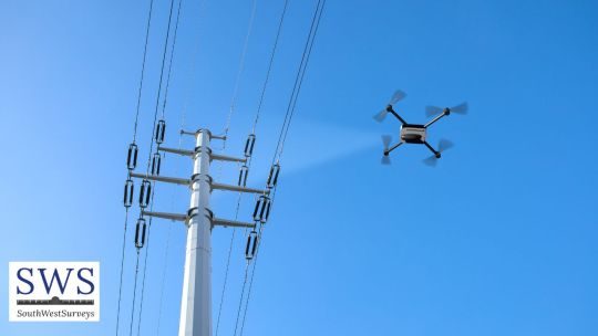
Enhancing Efficiency and Accuracy: The Advantages of Drone Surveyors in Coleford
youtube
In today's rapidly evolving world, technological advancements have revolutionized various industries, including surveying. Drone surveyors have emerged as an innovative solution, bringing a multitude of benefits to the field. This article explores how drone surveyors in Coleford, South West, are transforming traditional surveying practices, enhancing efficiency, and delivering accurate results.
Unleashing the Potential of Drone Surveyors Drone surveyors utilize unmanned aerial vehicles (UAVs) equipped with high-resolution cameras and advanced sensors to capture detailed imagery and data of vast areas quickly and efficiently. These cutting-edge devices are particularly beneficial for surveying projects in Coleford's challenging terrains, where conventional surveying methods might face limitations. With their ability to navigate difficult landscapes and reach inaccessible areas, drone surveyors offer a comprehensive and cost-effective solution.
Enhanced Efficiency and Time Savings One of the primary advantages of employing drone surveyors in Coleford is the significant improvement in efficiency and time savings. Traditional surveying methods often require manual labor, extensive equipment setup, and lengthy data collection processes. In contrast, drones can rapidly cover large areas within a short time, eliminating the need for labor-intensive ground surveys. By automating data collection, drone surveyors enable faster project completion, saving both time and resources for clients.
Superior Accuracy and High-Quality Data Accuracy is paramount in surveying, and drone surveyors excel in this aspect. Equipped with advanced imaging technology, drones capture high-resolution aerial images that provide accurate and detailed information for mapping, modeling, and analysis. The collected data can be processed using specialized software to create precise 3D models, topographic maps, and volumetric calculations. By minimizing human error and offering a more comprehensive perspective, drone surveyors deliver reliable and actionable insights to clients in Coleford.
Safety and Environmental Benefits Drone surveyors prioritize safety and reduce risks associated with traditional surveying methods. By replacing the need for personnel to traverse treacherous terrain, drones minimize the chances of accidents and injuries. Additionally, drone surveys minimize disturbance to the environment, as they operate without the need for extensive ground disruption. This environmentally-friendly approach aligns with the growing global emphasis on sustainability and responsible practices. South West Surveys' utilization of drone surveyors in Coleford demonstrates their commitment to both safety and ecological stewardship.
Applications in Various Industries Drone surveyors find applications across diverse industries, further exemplifying their versatility. In construction, drones aid in site analysis, progress monitoring, and quality control. Infrastructure planning benefits from the accurate data provided by drone surveys, assisting in road design, pipeline routing, and urban planning. In agriculture, drones contribute to precision farming, enabling crop health assessments and yield optimization. The renewable energy sector leverages drone surveys for site suitability analysis and maintenance inspections. The possibilities are vast, and drone surveyors are instrumental in delivering efficient and accurate results across multiple sectors.
Conclusion The utilization of drone surveyors in Coleford has revolutionized the field of surveying, enhancing efficiency, accuracy, and safety. South West Surveys' adoption of this cutting-edge technology reflects their commitment to delivering high-quality services. By harnessing the power of drone surveyors, clients in Coleford can expect timely, precise, and cost-effective surveying solutions for their projects.
#Drone Surveyors Coleford#Drone Surveyors Patchway#Drone Surveyors Gloucestershire#Drone Surveyors Gloucester#Drone Surveyors Dursley#Drone Surveyors Kingswood#Drone Surveyors Tetbury#Drone Surveyors Tewkesbury#Drone Surveyors Yate#Drone Surveyors Moreton-in-Marsh#Youtube
2 notes
·
View notes
Text
Solar Panel Drone Inspection: Enhancing Performance and Reducing Costs

As solar energy continues to expand globally, maintaining the efficiency and longevity of solar panels has become a top priority. One of the most efficient and advanced ways to ensure optimal performance is through drone-based solar panel inspections. Equipped with thermal and high-resolution cameras, drones offer a faster, safer, and more accurate method of identifying defects and inefficiencies in solar installations.
Why Inspections Are Crucial
Solar panels are exposed to harsh environmental conditions—dust, wind, rain, heat, and even bird droppings—all of which can reduce performance over time. Issues like micro-cracks, hotspots, loose connections, or shading can significantly affect a panel’s ability to generate electricity.
Routine inspections help detect these problems early, allowing for timely maintenance and minimizing power losses. While traditional inspection methods involve manual labor and handheld thermal cameras, these are often slow, dangerous, and prone to human error—especially in large-scale installations.
How Drone Inspections Work
Drone inspections involve flying UAVs over solar farms or rooftop panels using automated flight paths. The drones are equipped with two key types of sensors:
High-resolution RGB cameras capture detailed images of each panel’s surface, identifying physical damage like cracks, discoloration, or dirt buildup.
Thermal imaging cameras detect heat anomalies—hotspots—that indicate malfunctioning cells, electrical issues, or failed connections.
Captured data is processed through software that stitches together images into an orthomosaic map and flags irregularities. These results allow maintenance teams to locate and address problems quickly, without the need to manually inspect every panel.
Benefits of Drone-Based Inspections
Speed and Efficiency: Drones can inspect hundreds of panels in minutes, drastically reducing inspection time and system downtime.
Improved Safety: Workers avoid climbing on rooftops or walking across hot panel surfaces, reducing the risk of accidents and equipment damage.
Cost Savings: Fewer labor hours and faster problem resolution mean significant cost reductions over the life of the solar installation.
High Accuracy: Drones capture precise visual and thermal data, enabling detection of issues invisible to the human eye.
Scalability: Ideal for small rooftop arrays or large utility-scale solar farms, drone inspections adapt to projects of any size.
Data Tracking Over Time: Consistent drone inspections create historical records that help monitor panel degradation and improve maintenance planning.
Applications in the Solar Industry
Commercial and Utility-Scale Solar Farms: Drones offer unmatched speed and efficiency in inspecting vast solar arrays.
Rooftop Solar Installations: For residential or industrial buildings, drones offer a safe alternative to rooftop inspections.
Commissioning and Warranty Inspections: Drones help verify installation quality and compliance with warranty terms during handovers.
Post-Storm Damage Assessment: After extreme weather events, drones can quickly assess damage without risking human safety.
Conclusion
Solar panel drone inspection is revolutionizing how solar energy systems are maintained. By combining speed, safety, and precision, drones help identify problems early, reduce energy loss, and extend system life. As solar energy grows, drone technology will remain a critical tool in maximizing the efficiency, reliability, and return on investment of solar power installations.
0 notes
Text
RF Power Amplifiers Market to Expand with Advancements in Mobile Communication and IoT
RF power amplifiers market are essential components in the wireless communication industry, converting low-power radio signals into high-power outputs. These amplifiers are crucial in ensuring efficient transmission of signals in a wide array of applications, including mobile communication, broadcasting, radar, and satellite systems. As the demand for high-speed data transfer, better connectivity, and reliable communications increases, the RF power amplifiers market has seen significant growth. This article delves into the current state of the RF power amplifiers market, its driving factors, challenges, and future trends.
Market Overview
The RF power amplifiers market is expected to grow steadily due to the surge in demand for mobile and wireless communication systems. With the advent of 5G technology, RF power amplifiers have become more critical than ever. The need for robust, high-efficiency amplifiers is growing across sectors such as telecommunications, automotive, and defense, where large volumes of data need to be processed and transmitted over wireless networks.
RF power amplifiers are integral to both the transmission and reception of wireless signals, providing the necessary power to broadcast signals over long distances. As the market for mobile devices and wireless communication expands, so too does the demand for power amplifiers that can support higher frequencies, better efficiency, and reduced power consumption.
Market Drivers
5G Deployment: One of the most significant drivers of the RF power amplifiers market is the global rollout of 5G networks. The fifth-generation wireless technology demands advanced RF power amplifiers that can operate at higher frequencies and deliver higher power with better efficiency. As 5G networks expand, RF power amplifiers will play a critical role in meeting the performance requirements for both consumer and enterprise applications.
Internet of Things (IoT): The rise of IoT devices has increased the need for high-efficiency power amplifiers. These devices, which require seamless connectivity, rely on efficient RF power amplification to transmit data over wireless networks. IoT applications such as smart cities, autonomous vehicles, and industrial automation all contribute to the growing demand for reliable RF power amplifiers.
Telecommunications and Broadcasting: The telecommunications industry has traditionally been one of the largest consumers of RF power amplifiers. The need for stronger, more efficient amplifiers is driven by the increasing volume of voice, video, and data traffic that is being transmitted over cellular networks. Moreover, RF power amplifiers are indispensable in broadcasting applications, ensuring high-quality transmission of radio and TV signals.
Military and Aerospace Applications: RF power amplifiers are crucial in defense and aerospace applications, where reliability and high performance are non-negotiable. Whether in satellite communication, radar systems, or unmanned aerial vehicles (UAVs), these amplifiers ensure robust signal transmission over long distances, even in hostile environments.
Market Challenges
Despite the growth prospects, the RF power amplifiers market faces several challenges:
Technological Complexity: As the need for higher efficiency and broader bandwidth grows, designing RF power amplifiers that meet these requirements while maintaining affordability becomes more difficult. Manufacturers must continuously innovate to create amplifiers that perform well across various frequency ranges without sacrificing power efficiency or signal integrity.
Thermal Management: RF power amplifiers, especially in high-power applications, generate significant heat. Effective thermal management is essential to prevent damage and ensure long-term reliability. Developing amplifiers that offer high power output without overheating remains a key challenge for manufacturers.
Cost of Production: The cost of producing high-quality RF power amplifiers can be significant, particularly for advanced technologies like GaN (Gallium Nitride) and GaAs (Gallium Arsenide) amplifiers. While these materials offer superior performance, their high production cost can limit the widespread adoption of cutting-edge RF power amplifier technologies.
Market Outlook
The RF power amplifiers market is poised for continued growth over the next several years, driven by technological advancements and increasing demand for wireless communication systems. As 5G networks expand globally and new applications in IoT, automotive, and aerospace emerge, the need for high-performance, cost-effective RF power amplifiers will continue to rise.
Manufacturers are investing in research and development to address the challenges of power efficiency, thermal management, and cost-effectiveness. Furthermore, the adoption of next-generation materials, such as GaN, which offer higher power efficiency and thermal management capabilities, will likely play a key role in shaping the future of the market.
Conclusion
The RF power amplifiers market is a dynamic sector within the telecommunications and electronics industries. As global demand for faster, more reliable communication systems grows, the role of RF power amplifiers will become even more critical. With advancements in technology, particularly in 5G and IoT, the market is expected to see significant growth. Manufacturers that can overcome technological challenges and deliver efficient, high-performance amplifiers will be well-positioned to capture market share in this rapidly expanding industry.
#RFPowerAmplifiers#5GTechnology#WirelessCommunication#Telecommunications#IoTDevices#PowerAmplification
0 notes
Text
Aerospace & Military Fiber Optic Market Set to Grow to $7.8 Billion by 2034
Aerospace And Military Fiber Optic Market is projected to soar from $4.2 billion in 2024 to a staggering $7.8 billion by 2034, growing at a CAGR of 6.4%. This market fuels the development of robust fiber optic technologies that support advanced communications, navigation, and mission-critical operations in both military and aerospace sectors. From data transmission to sensor systems, the integration of fiber optics ensures lightweight, secure, and high-speed performance, especially in environments where traditional copper solutions fall short. With a growing need for seamless connectivity and hardened systems, fiber optics continue to revolutionize the aerospace and defense landscape.
Click to Request a Sample of this Report for Additional Market Insights: https://www.globalinsightservices.com/request-sample/?id=GIS25848
Market Dynamics
Demand for reliable, high-bandwidth data transmission is a primary force accelerating this market’s growth. In military operations, real-time communication and battlefield awareness rely heavily on low-latency, interference-resistant fiber optic networks. On the commercial side, aircraft systems — from inflight connectivity to avionics — benefit from the lightweight and durable nature of fiber optics. Technological trends like unmanned aerial vehicles (UAVs), autonomous systems, and electronic warfare are pushing boundaries, driving innovation in fiber components and configurations. Meanwhile, challenges such as integration complexity, high installation costs, and supply chain disruptions present barriers to scalability, particularly for emerging markets and smaller firms.
Key Players Analysis
Major companies dominating the aerospace and military fiber optic market include Corning Inc., TE Connectivity, Amphenol Corporation, and Radiall. These players are leveraging advanced R&D capabilities, strategic acquisitions, and global partnerships to strengthen their competitive edge. Meanwhile, emerging firms such as Aero Fiber Innovations and Nova Wave Optics are bringing fresh momentum with niche innovations and tailored defense-grade solutions. These companies are aligning with government regulations and defense standards while pioneering future-forward technologies like space-division multiplexing and modular fiber optic systems.
Regional Analysis
North America leads the charge, primarily driven by the United States, which invests heavily in defense modernization and aerospace innovation. With its deep-rooted infrastructure and technological prowess, the region remains a hotbed for both commercial aviation and defense-grade fiber optic advancements. Europe follows closely, led by Germany and the United Kingdom, benefiting from collaborative efforts between state defense agencies and fiber manufacturers. Asia Pacific is an emerging powerhouse, with China and India ramping up defense budgets and pursuing aerospace modernization. The Middle East and Africa are seeing stable growth due to increasing military investments, particularly in countries like Saudi Arabia and the UAE. Latin America, while still in early phases, shows promise with modernization efforts in Brazil and Mexico.
Recent News & Developments
The market has recently witnessed major strides in lightweight fiber materials and hybrid systems that can withstand extreme conditions. Innovations like photonic crystal fibers and optical time-domain reflectometers are transforming how data is transmitted and monitored. Strategic mergers and collaborations — such as joint ventures between fiber optic manufacturers and defense contractors — are becoming more frequent, aiming to deliver scalable, mission-ready systems. Meanwhile, pricing dynamics are evolving. Although high-performance fiber optics still come at a premium, improvements in manufacturing processes are gradually making these systems more cost-effective and accessible across various scales of operation.
Browse Full Report : https://www.globalinsightservices.com/reports/aerospace-and-military-fiber-optic-market/
Scope of the Report
This report offers in-depth insights into the aerospace and military fiber optic market, segmented by type, product, services, technology, component, application, material type, device, deployment, and end user. It includes both qualitative and quantitative analysis, covering key drivers, restraints, opportunities, and competitive benchmarking. Our research dives into regional landscapes, highlighting local competition, purchasing behavior, and investment trends. From SWOT assessments to regulatory frameworks, this comprehensive view is essential for businesses and stakeholders aiming to navigate and capitalize on one of the most dynamic sectors in modern aerospace and defense.
Discover Additional Market Insights from Global Insight Services:
Silos Market : https://www.globalinsightservices.com/reports/silos-market/
Military Vehicle Electrification Market : https://www.globalinsightservices.com/reports/military-vehicle-electrification-market/
Baggage Handling System Market : https://www.globalinsightservices.com/reports/baggage-handling-system-market/
Electric Forklift Market : https://www.globalinsightservices.com/reports/electric-forklift-market/
Unmanned Underwater Vehicles (UUV) Market : https://www.globalinsightservices.com/reports/unmanned-underwater-vehicles-uuv-market/
#fiberoptics #aerospacetechnology #militarytech #defensetechnology #fiberopticsolutions #militaryinnovation #avionics #opticalcommunications #highspeeddatatransfer #lightweightmaterials #securecommunications #uavsystems #electronicwarfare #militarymodernization #defenseinfrastructure #communicationnetworks #optoelectronics #globaldefense #aviationtech #teconnectivity #corning #amphenol #radiall #opticalfiber #spaceexploration #fiberopticcables #militaryapplications #aerospaceengineering #connectivitysolutions #emergingtech #northamericamarket #asiapacificgrowth #defensespending #advancedmaterials #securedata #highperformancecomponents #missioncritical #smartdefense #nextgentech #opticallinks
About Us:
Global Insight Services (GIS) is a leading multi-industry market research firm headquartered in Delaware, US. We are committed to providing our clients with highest quality data, analysis, and tools to meet all their market research needs. With GIS, you can be assured of the quality of the deliverables, robust & transparent research methodology, and superior service.
Contact Us:
Global Insight Services LLC 16192, Coastal Highway, Lewes DE 19958 E-mail: [email protected] Phone: +1–833–761–1700 Website: https://www.globalinsightservices.com/
0 notes
Text
0 notes
Text
Virtual Simulation of UAV (Unmanned Aerial Vehicle) Delivery in WebGIS
With the breakthroughs in core technologies such as drones and eVTOLs, the application scenarios of the low-altitude economy have been greatly expanded. It has extended from traditional fields such as agricultural and forestry plant protection and industrial line inspection to emerging fields such as urban air mobility and low-altitude logistics distribution, opening up new paths for the digital and intelligent transformation of numerous industries.
Hightopo uses low-code digital twin tools to create a lightweight smart city GIS low-altitude economy drone operation and maintenance monitoring platform. In scenarios such as airspace management, smart logistics, and food delivery, it achieves service innovation goals such as route optimization, cost control, and risk early warning. Combined with spatial semantic analysis, it provides a 3D perspective, enabling intelligent route planning and dynamic navigation, and has irreplaceable advantages in core functions such as route optimization, task collaboration, and risk prediction.
Dispatcher Center GIS Urban Modeling Relying on its self-developed HT 2D and 3D collaborative design and low-code development tools, Hightopo constructs a dynamic GIS 3D digital twin urban scenario. This scenario restores urban elements such as terrain, buildings, road networks, and vegetation with high precision, supports highly customized modeling, and improves the accuracy and efficiency of urban planning and design. At the same time, it provides high-precision ground reference information for drones, enabling precise navigation and intelligent obstacle avoidance.
Food Delivery - Delivery Track Monitoring It monitors the whole process of drones from taking off at the merchant until delivering the food to the pickup cabinet, ensuring the safety of the drone delivery process and promptly responding to possible abnormal situations.
Drone Queuing Delivery Mechanism During peak hours, there may be situations where multiple drones deliver to the same pickup cabinet at the same time. To avoid air traffic congestion and improve delivery efficiency, the platform uses real-time monitoring, intelligent scheduling algorithms, and high-speed communication technologies to provide data analysis and decision-making support for managers, achieving orderly drone delivery.
Data Statistics and Monitoring It collects and analyzes delivery operation data, covering aspects such as delivery data in various regions, delivery efficiency statistics, and equipment utilization rates. Through the analysis of these data, it explores potential opportunities to optimize delivery routes and strategies and improve delivery efficiency.


1 note
·
View note
Text
Elevating Aerial Surveillance: The Rise of Airborne Optronics in Modern Reconnaissance
Introduction
In the realm of modern defense and intelligence, the integration of advanced technologies has become paramount. Among these, airborne optronics—a fusion of optical and electronic systems—has emerged as a cornerstone for enhancing surveillance and reconnaissance capabilities.
Market Overview
The global airborne optronics market is experiencing significant growth. Valued at approximately USD 1.5 billion in 2022, it is projected to reach USD 4.8 billion by 2032, growing at a compound annual growth rate (CAGR) of 12.4% from 2023 to 2032 . This expansion is driven by advancements in sensor technologies and the increasing demand for enhanced surveillance and reconnaissance capabilities across military and commercial sectors.
Technological Advancements
Modern airborne optronics systems incorporate cutting-edge technologies, including:
Multispectral and Hyperspectral Sensors: Enabling precise detection and identification of targets across various wavelengths.
Infrared Imaging: Providing enhanced visibility in low-light and adverse weather conditions.
Laser Rangefinders and Designators: Facilitating accurate targeting and guidance.
Artificial Intelligence (AI) Integration: Allowing for automated target recognition and real-time data processing .
Applications
Airborne optronics systems are pivotal in various applications, including:
Military Surveillance: Monitoring and reconnaissance of potential threats.
Border Patrol: Ensuring national security through vigilant monitoring.
Search and Rescue Operations: Assisting in locating and aiding individuals in distress.
Environmental Monitoring: Tracking changes in ecosystems and natural resources.
Regional Insights
The Asia-Pacific region is anticipated to witness the fastest growth in the airborne optronics market during the forecast period. This growth is attributed to increasing defense budgets, the proliferation of unmanned aerial vehicles (UAVs), and the rising demand for advanced surveillance and reconnaissance capabilities .
Conclusion
As the demand for advanced surveillance and reconnaissance capabilities continues to rise, airborne optronics systems are set to play a crucial role in modern defense and intelligence operations. Their integration of advanced technologies ensures enhanced situational awareness and operational effectiveness, marking a significant advancement in aerial surveillance.
Datatring Consulting for more .
0 notes
Text
How UAV Data Processing is Revolutionizing Landscape Rendering Services?
Revolutionize the way Landscape Rendering Services are perceived, planned, and executed with GeoShot.org. If you've ever marveled at the intricate details of rendered landscapes or wondered how planners bring these breathtaking scenes to life, you're in for a treat. Today, we delve into the fascinating world where cutting-edge technology and creative design meet, thanks to UAV computing.
Imagine vast landscapes, majestic mountains, lush forests, and city skylines - all from a bird's eye view. This is the magic of unmanned aerial vehicles (UAVs), commonly known as drones. These uninhabited wonders do more than just capture breathtaking aerial photos. These are revolutionizing the way Landscape Rendering Services are perceived, planned, and executed.
As technology advances, so will the synergies between UAV Data Processing and landscape imagery services. From AI-driven analytics to real-time visualization tools, the future looks brighter than ever for landscape enthusiasts and professionals. This concludes our exciting tour of how UAV computing is reshaping the world of landscape imagery. From taking aerial photographs to creating immersive visualizations, it's a journey that combines equal parts science, art, and innovation. So the next time you see a stunning rendered landscape, remember that it all started with a drone in the sky.
For more info, please email at: [email protected] & Visit Us: https://writeupcafe.com/how-uav-data-processing-is-revolutionizing-landscape-rendering-services/
0 notes
Text
The Future of Fire Safety: How Fire Fighting Drones Are Saving Lives

As technology continues to evolve, so too does the way we tackle emergencies—especially fires. One of the most groundbreaking innovations in recent years is the development and deployment of fire fighting drones. These advanced aerial tools are transforming fire safety by providing faster response times, enhanced visibility, and greater protection for both firefighters and civilians.
In high-risk situations where every second counts, fire fighting drones are proving to be not just useful—but lifesaving.
What Are Fire Fighting Drones?
Fire fighting drones are unmanned aerial vehicles (UAVs) equipped with specialized tools designed to aid in fire detection, suppression, and rescue operations. Depending on their design, these drones may carry thermal cameras, water or fire-retardant payloads, loudspeakers, sensors, or even extendable hoses.
By flying into dangerous or hard-to-reach areas, drones can perform vital tasks without putting human lives at immediate risk.
How Fire Fighting Drones Are Changing the Game
Rapid Assessment & Aerial Surveillance Fire fighting drones provide a bird’s-eye view of fire-affected areas. Equipped with high-resolution and thermal imaging cameras, they help first responders assess the extent of the fire, identify hotspots, and track its spread in real time. This aerial data enables faster decision-making and more strategic deployment of firefighting resources.
Access to Hard-to-Reach Areas High-rise buildings, industrial zones, forests, and disaster-stricken regions can be challenging—and dangerous—for ground teams. Drones can easily access these areas and gather critical data without delay, making them ideal for urban fires, wildfires, and collapsed structures.
Fire Suppression Capabilities Some advanced fire fighting drones are capable of carrying water or fire-retardant chemicals and releasing them precisely over fire zones. While they currently cannot replace large fire trucks or aircraft, these drones offer valuable support during the early stages of a fire or in locations inaccessible to traditional equipment.
Enhanced Firefighter Safety By taking on surveillance and suppression roles, drones reduce the need for firefighters to immediately enter hazardous zones. This significantly lowers the risk of exposure to heat, smoke, structural collapse, or explosion.
Search and Rescue Support In smoky, low-visibility conditions, thermal drones can detect human body heat and help locate trapped victims faster than ground searches alone. This can be especially critical during nighttime operations or in large-scale disasters.
Real-World Applications
Forest and Wildland Fires: Fire fighting drones help map out massive fire zones and identify safe paths for evacuation or rescue.
Urban Fires: Drones can monitor high-rise buildings and confined areas without endangering human crews.
Industrial Fires: In chemical plants or warehouses, drones provide safe surveillance to prevent secondary explosions or toxic exposure.
The Future of Fire Fighting Drones
As drone technology becomes more advanced and affordable, we can expect broader adoption across fire departments and emergency services globally. Integration with AI, 5G connectivity, and real-time data analytics will make drones even more effective in predictive fire safety and crisis management.
Conclusion
Fire fighting drones are no longer just futuristic concepts—they’re vital tools in modern emergency response. By offering speed, accuracy, and safety, these drones are not only revolutionizing fire safety but actively saving lives in the process.
As we look toward a future of smarter cities and disaster resilience, fire fighting drones will play an increasingly central role in protecting people, property, and the environment.
0 notes
Text
Headwall Photonics and GRYFN Partner to Simplify Hyperspectral Data Processing
Key Takeaways Headwall Photonics and GRYFN announce a strategic partnership to integrate hyperspectral imaging hardware with advanced data processing software. The joint solution targets applications in agriculture, environmental monitoring, natural resources, and defense. The GRYFN Processing Tool will now be offered with Headwall systems to support UAV-based hyperspectral, LiDAR, and GNSS data…
0 notes
Text
Aerial Survey with Epitome Geotechnical
An aerial survey is the process of collecting geospatial data from airborne platforms such as drones (UAVs), helicopters, or fixed-wing aircraft. This modern surveying method enables rapid, accurate, and high-resolution data acquisition over large or difficult-to-access areas. At Epitome Geotechnical, we provide advanced aerial survey solutions that support a wide range of geotechnical, environmental, and infrastructural projects.
Why Choose Epitome Geotechnical for Aerial Survey Services
At Epitome Geotechnical, we are committed to delivering accurate, efficient, and technology-driven aerial survey solutions that exceed client expectations. Here’s why clients across various sectors trust us with their surveying needs:

Expertise in Geotechnical and Geospatial Services Our background in geotechnical engineering gives us a deep understanding of terrain analysis, site planning, and data accuracy—ensuring that the aerial survey results are aligned with engineering requirements and project goals.
Advanced Technology and Equipment We use state-of-the-art UAVs, LiDAR systems, and high-resolution sensors combined with RTK/PPK GPS technology to produce survey-grade results. This ensures every dataset is precise, reliable, and ready for decision-making.
Customized Survey Solutions No two projects are the same. We provide tailored aerial survey plans based on the specific needs of each site—whether it’s for environmental monitoring, infrastructure development, or volume estimation.
Safety-First Approach Our aerial survey services significantly reduce the need for personnel to work in hazardous or difficult terrain. Safety is a cornerstone of our operations, and aerial methods allow us to gather data without compromising site or worker safety.
Fast Turnaround and Cost Efficiency With rapid data acquisition and streamlined post-processing, we help our clients save valuable time and resources—delivering results faster and more affordably than traditional surveying methods.
End-to-End Support From planning and data collection to analysis and final deliverables, our team supports you throughout the entire aerial survey process. We ensure seamless integration of aerial data into your project workflow.
Future of Aerial Survey at Epitome Geotechnical
At Epitome Geotechnical, we are continuously investing in the future of aerial survey technology to serve our clients better. Our focus is on staying ahead with innovation, accuracy, and smarter solutions. Here's what the future looks like with us:
Smarter Drones We aim to integrate AI-powered drones for automated data capture, analysis, and real-time reporting.
Real-Time Data Access Future clients will benefit from live project monitoring and instant access to survey data.
Advanced 3D Modeling We plan to offer even more detailed and interactive 3D models for better planning and visualization.
Expanded Services We are working to include aerial thermal inspections, underground utility mapping, and more specialized services.
Sustainable Surveying Our future surveys will focus on environmentally friendly practices with minimal impact on nature.
Conclusion
Aerial survey technology is transforming the way we gather, analyze, and apply geospatial data. At Epitome Geotechnical, we combine technical expertise with advanced aerial systems to deliver accurate, efficient, and cost-effective solutions for a wide range of industries. Whether it’s for construction, environmental monitoring, or land development, our aerial survey services provide the insight and reliability you need to make informed decisions.
#epitome#epitomegs#GIS Mapping Survey in India#GIS Mapping Survey#GIS Mapping Company in India#Drone Survey#aerial photography survey#aerial survey
0 notes
Text
The Advancements and Importance of 3D Land Surveying
For many years, land surveying has been a crucial part of engineering, land development, and building. Traditional 2D procedures are quickly being superseded by more accurate and effective techniques as a result of technological advancements. 3D land surveying is among this field's most groundbreaking innovations. Professionals in a variety of industries may make well-informed judgments thanks to this contemporary surveying technique, which provides a thorough, precise, and three-dimensional depiction of the landscape.
3D Land Surveying: What Is It?
In order to gather comprehensive spatial data about the earth's surface, it uses cutting-edge instruments and technologies like laser scanners, GPS, drones, and LiDAR (Light Detection and Ranging). In order to extract measurements, contours, and other geographical information, the gathered data is then processed into a digital 3D model called a point cloud, which may be examined and altered in software settings.
3D Land Surveying provides a dynamic and extremely detailed representation of terrain elements, such as elevations, slopes, and structural layouts, in contrast to traditional surveying, which depends on manual equipment and flat representations. This lowers the time and effort required for fieldwork while also increasing accuracy.
Uses for Three-D Land Surveying
Because of its adaptability, this is beneficial in a variety of industries:
Civil engineering and construction: 3D models are used by architects and engineers for site planning, design verification, and progress monitoring. It reduces expensive alterations and delays by spotting any problems before construction starts.
Urban Planning and Development: With 3D data, urban planners may more effectively plan transportation systems, evaluate the effects on the environment, and simulate infrastructure layouts.
Mining and Quarrying: To track excavation progress, compute volumes, and make sure safety regulations are followed throughout mining operations, surveyors utilize 3D models.
In agriculture and forestry: 3D surveying helps with crop analysis, planning irrigation, and managing forests, all of which increase productivity and sustainability.
3D Land Surveying Advantages
Accuracy is one of the key benefits of 3D land surveying. In just a few minutes, it can gather millions of data points and produce intricate models with little error. Furthermore, surveyor hazards are decreased by the safe access to dangerous or difficult-to-reach locations made possible by the use of UAVs and remote sensors.
Furthermore, efficiency is greatly increased by 3D surveying. Today, tasks that used to take days or weeks can be finished in a fraction of the time. Cloud-based solutions also make it simpler for teams to interact and exchange data.
Conclusion
The way we engage with the real world has advanced significantly with 3D land surveying. In addition to improving data gathering speed and accuracy, it offers deep, useful insights that are advantageous to a variety of sectors. 3D surveying will probably become the norm as technology develops further, expanding the realm of what is feasible in terms of land management and measurement. The future of mapping analysis is being transformed by these surveying, a potent tool for professionals looking for accuracy, security, and efficiency.
For More Inquiry: Contact Us
0 notes