#Upper Mississippi River National Wildlife and Fish Refuge
Link
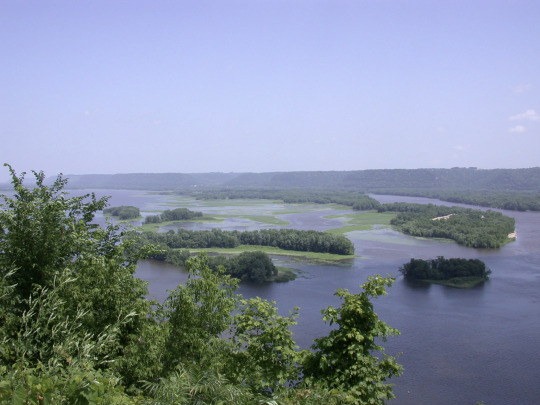
Upper Mississippi River National Wildlife and Fish Refuge.
Excerpt from this story from Madison.com:
A federal appeals panel heard arguments Wednesday in a case involving a controversial power line through southwest Wisconsin that could influence future permitting decisions on lines considered critical for a clean energy transition.
Conservation groups oppose the line, known as Cardinal-Hickory Creek, which would run 102 miles between Dubuque, Iowa, and Middleton. They argue it is unneeded and too expensive, would mar the Driftless landscape and cannot legally cross the Upper Mississippi River National Wildlife and Fish Refuge.
Utilities building the project at a cost of more than $500 million say it will improve reliability and deliver clean energy to places where it’s needed, while industry groups and academics argue the electric grid needs far more such long-distance lines to wean itself off fossil fuels.
The utilities are seeking to overturn U.S. District Court Judge William Conley’s ruling that the environmental review for the line was inadequate and that the project is incompatible with the wildlife refuge.
Conley barred the utilities from building within the 260,000-acre refuge, effectively blocking the planned river crossing, and ruled that a proposed land exchange cannot be used “to evade Congress’ mandate” for the refuge, which covers 261 river miles between Rock Island, Illinois, and Wabasha, Minnesota.
While they have not presented any alternative routes, the utilities have continued construction on either side of the river, spending at least $337.5 million, according to the most recent quarterly report to state regulators.
Opponents have asked the court to overturn Conley’s ruling that utilities can build outside of the refuge, which he called an “orchestrated train wreck.”
The appeals panel, composed of two Republican appointees and one Democratic appointee, appeared skeptical of the argument that the Fish and Wildlife Service could sidestep statutory requirements with a land swap.
#Upper Mississippi River National Wildlife and Fish Refuge#electricity transmission grid#Wisconsin#driftless area
4 notes
·
View notes
Text
Most Famous Picnic Place in Michigan
Michigan is a state that is known for its natural beauty and outdoor activities. There are many excellent places throughout the state where you can get away from the hustle and bustle of city life, including picnic spots that offer great views and access to nature, including lakes and streams.

Pictured Rocks National Lakeshore
Pictured Rocks National Lakeshore, America’s first National Lakeshore, is along the southern shore of Lake Superior in Michigan’s beautiful Upper Peninsula. With stunning beaches, 10 inland lakes, and nearly 100 miles of trails, everyone can find something to enjoy at Pictured Rocks!
No matter the time of year, there is something to do at Pictured Rocks!
Summer: visit beaches, backpack, and camp (permit required). Looking for views of the cliffs? The best way to see the cliffs is from the water on a commercial boat tour.
Fall: Autumn colors in the Upper Peninsula are often breathtaking, drive the park roads to view the changing leaves! Hunting and fishing opportunities (state regulations apply) abound during fall!
Winter: Cold weather brings otherworldly frozen waterfalls, called “curtains”. Snowshoeing, skiing, and ice fishing are other popular winter activities. Check road closures and conditions before heading into the park in the winter.
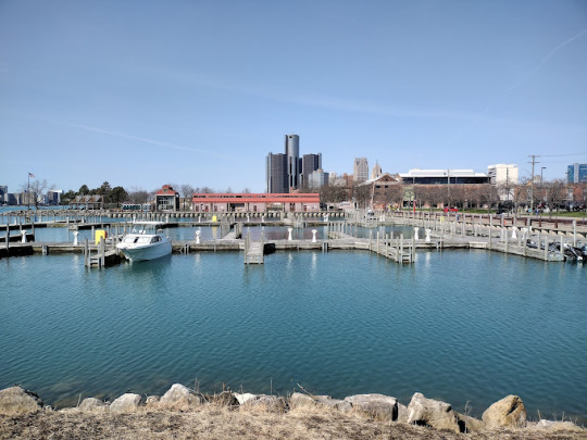
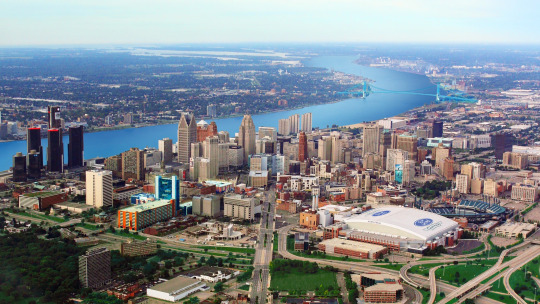
William G. Milliken State Park and Harbor
William G. Milliken State Park and Harbor is located in the heart of Detroit, just east of downtown, along a portion of the city’s Detroit Riverwalk, which provides easy access for fishing, biking, walking and rollerblading.
The park is divided into three areas, including the harbor, the picnic shelter area and the popular berm area. Thanks to recent renovations, the berm now boasts an accessible walkway, handrails and new trees, shrubs and grass. The berm area is especially popular for picnics and wildlife viewing.
At the top of the berm, visitors can view the river and our neighbors in Canada through two new spotting scopes, courtesy of the Detroit River International Wildlife Refuge and Enchroma, that provide an enhanced color view for visitors who are color blind. The berm also boasts an accessible walkway and handrails.
The state harbor provides 52 slips, as well as showers, a laundry facility, grills and picnic tables.
The park is conveniently located near the Outdoor Adventure Center, Belle Isle Park and many other major downtown Detroit attractions.
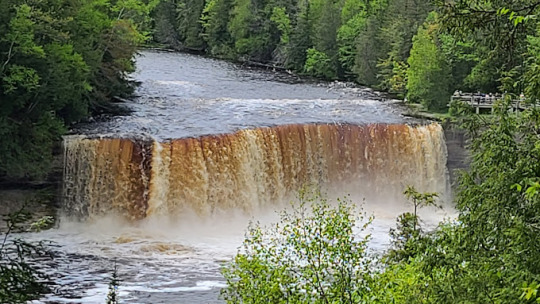
Tahquamenon Falls State Park
Tahquamenon Falls State Park encompasses nearly 50,000 acres and stretches 13-plus miles in Michigan's Upper Peninsula. The park is home to multiple campgrounds, overnight lodging facilities, a boat launch, more than 35 miles of trails and multiple overlooks to the Upper and Lower Falls.
The 200-feet-wide Upper Falls is one the largest waterfalls east of the Mississippi River. The river’s amber color is caused by tannins leached from the cedar, spruce and hemlock trees in the swamps drained by the river, and the extremely soft water churned by the action of the falls causes the river’s trademark large amounts of foam. Just 4 miles downstream is the Lower Falls, consisting of a series of five smaller falls cascading around an island. The falls can be viewed from the riverbank, all-accessible Ronald A. Olson Island Bridge (honoring DNR Parks and Recreation Division chief) over the Tahquamenon River or by a rowboat rented from a park concession. Drone use is prohibited.

Value Plus Auto Parts is an auto parts supplier in the United States. We offer all kinds of automotive parts, from tires and wheels to shocks and struts, you name it. We also carry a wide variety of accessories such as car audio systems and dash kits.
We have a comprehensive range of replacement parts for both domestic and foreign vehicles. Our team of experts is dedicated to providing high-quality products at reasonable prices. We believe in delivering exceptional customer service so we can build long-lasting relationships with our customers.
Value Plus Auto Parts
8121 Livernois, Detroit, MI 48204, USA
+1 31 3931 9999
https://valueplusautopartswholesale.com
https://www.google.com/maps?cid=10429367345021126601
0 notes
Conversation
U.S. Daily Precipitation Records Tied/Broken 12/9/22
Unincorporated Southeast Fairbanks Census Area, AK: 0.1" (also 0.1" 2011)
Camden, Arkansas: 2" (previous record 1.71" 1951)
De Roane Township, Arkansas: 3" (previous record 2.25" 2008)
Fordyce, Arkansas: 1.82" (previous record 1.62" 1986)
Jasper, Arkansas: 2.5" (previous record 2.24" 1994)
Cedar Pass summit, California: 0.5" (also 0.5" 2015)
Unincorporated Butte County, Idaho: 0.5" (previous record 0.18" 1987)
Buffalo Rock State Park, Illinois: 0.7" (previous record 0.52" 2008)
Canton, Illinois: 0.48" (previous record 0.46" 1953)
Elizabeth Township, Illinois: 0.66" (previous record 0.31 1987)
Macomb, Illinois: 0.76" (previous record 0.57" 1931)
Peoria, Illinois: 0.6" (previous record 0.53" 1997)
Union Township, Illinois: 0.65" (previous record 0.58" 2009)
Upper Mississippi River Wildlife & Fish Refuge, IL: 0.7" (previous record 0.6" 2009)
Bellevue, Iowa: 0.58" (previous record 0.31" 2008)
Cedar Rapids, Iowa: 0.73" (previous record 0.5" 2009)
Cherokee, Iowa: 0.67" (previous record 0.29" 2009)
DeWitt, Iowa: 0.7" (previous record 0.68" 2009)
Iowa City, Iowa: 0.66" (previous record 0.65" 1897)
Marshalltown, Iowa: 0.6" (previous record 0.56" 2009)
New Hampton, Iowa: 0.58" (previous record 0.5" 1918)
Newton, Iowa: 0.5" (previous record 0.39" 2009)
Primghar, Iowa: 0.66" (previous record 0.5" 1899)
Sioux Rapids, Iowa: 0.58" (previous record 0.24" 2009)
Spencer, Iowa: 0.42" (previous record 0.11" 2003)
Spirit Lake, Iowa: 0.67" (previous record 0.23" 2003)
Rochester, Minnesota: 0.44" (previous record 0.35" 2012)
Wells, Minnesota: 0.66" (previous record 0.51" 1987)
Canton Township, Missouri: 0.49" (previous record 0.4" 2009)
Custer National Forest, Montana: 0.6" (also 0.6" 2015)
Lone Mt. summit, Montana: 0.3" (also 0.3" 1996)
Minatare Lake State Recreation Area, Nebraska: 0.21" (previous record 0.04" 2021)
Fremont National Forest, Oregon: 0.5" (also 0.5" 2016)
Malheur National Forest, Oregon: 0.5" (previous record 0.4" 2016)
Bridgewater, South Dakota: 0.55" (previous record 0.22" 1967)
Unincorporated Lake County, South Dakota: 0.72" (previous record 0.23" 2012)
Rosebud Indian Reservation, South Dakota: 0.49" (previous record 0.3" 2003)
Wood, South Dakota: 0.46" (previous record 0.32" 1918)
Maud, Texas: 2.02" (previous record 1.87" 1986)
Brooks Memorial State Park, Washington: 0.57" (previous record 0.54" 2016)
Odessa, Washington: 0.75" (previous record 0.51" 1933)
Richland Township, Wisconsin: 0.28" (previous record 0.22" 2012)
#Storms#U.S.A.#U.S.#Arkansas#1950s#1980s#1990s#Idaho#Illinois#1930s#Iowa#1890s#1910s#Minnesota#Missouri#Nebraska#South Dakota#1960s#Texas#Washington#Montana#Oregon#Alaska#Wisconsin#Crazy Things#Awesome
0 notes
Photo

Northern Map Turtle (via USFWS Midwest Region)
We found this northern map turtle crossing the road and helped it reach its destination safely.
Photo by Courtney Celley/USFWS.
#Northern Map Turtle#Graptemys geographica#Graptemys#Deirochelyinae#Emydidae#Testudinoidea#Cryptodira#Testudines#turtle#Upper Mississippi River National Wildlife and Fish Refuge#Minnesota
20 notes
·
View notes
Video
Waterfowling on Upper Mississippi River National Wildlife and Fish Refuge by USFWSmidwest
Via Flickr:
Hallie Rasmussen waterfowl hunting with her dog Finn on Upper Mississippi River National Wildlife and Fish Refuge. Photo by USFWS.
#Midwest#Hunting#Hunt#Waterfowl Hunting#Waterfowl#People#Hunting Heritage#Duck Hunting#Women Hunting#Upper Mississippi River#National Wildlife and Fish Refuge#NWFR#Staff#Employee#Now Playing#14th#November#2017#November 14th 2017
9 notes
·
View notes
Photo

Mayflies are hatching on the Upper Mississippi River!
This giant mayfly is part of the species Hexagenia limbata and is one of two species you can help report sightings of to the USA National Phenology Network.
Learn more about Mayfly Watch here:
https://fws.usanpn.org/Campaigns/MayflyWatch
Photo by Jamie Bertram/USFWS.
via: Upper Mississippi River National Wildlife & Fish Refuge - Wisconsin
#mayfly watch#mayfly#mayflies#ephemoptera#entomology#insect#animals#nature#science#north america#aquatic#rivers
12 notes
·
View notes
Link

A live-streaming webcam has chronicled the history of a rare family of bald eagles on Upper Mississippi River National Wildlife and Fish Refuge to audiences all over the world.
96 notes
·
View notes
Photo


I saw some amazing taxidermy at the Upper Mississippi River National Fish and Wildlife Refuge today! They even had a little area where you could touch various feathers, turtle shells and bones.
Most of the mounts looked extremely well done, if you’re ever in the area I definitely recommend checking it out!
#Long Post#Vulture Culture#Taxidermy#American White Pelican#Bald Eagle#American Mink#American Coot#Canada Goose#Great Horned Owl#Belted Kingfisher#Not sure what the duck is though :/
7 notes
·
View notes
Link
Parenting can be a challenge, but a trio of bald eagles in Illinois have banded together to tackle it.
In an unorthodox nest on the Mississippi River in northwest Illinois, two male eagles named Valor I and Valor II and a female eagle named Starr are sharing baby-raising duties.
So far this year, the proud parents have successfully produced and hatched three eggs, said Pam Steinhaus, visitor services manager at the Upper Mississippi River National Wildlife and Fish Refuge.
The Stewards of the Upper Mississippi River Refuge have set up a live stream of the site, where the eagles can be seen taking turns feeding the eaglets and taking care of the nest.
The threesome splits up the work pretty evenly.
"They are involved in all aspects," Steinhaus said. "Everybody brings in sticks. The boys put the sticks where they think (they go), and Starr always moves them back to where she thinks it (should go)."
When it comes to incubation, Starr does a lot of the work. But when she gets tired, the dads step in.
"The boys are right there to remove her and sit on the eggs," Steinhaus said.
The trio makes sure everyone is well fed, and the three eaglets look like they're developing right on schedule, she added.
"The pantry is constantly full. Food is never going to be an issue."
It's uncommon for bald eagles to parent in threes, according to the National Audubon Society, a bird conservation group. Previous trios have been spotted in Alaska in 1977, Minnesota in 1983 and California in 1992.
One of the male eagles needed some parenting help
In 2012, Valor I paired up with a female eagle dubbed Hope. But he wasn't a great parent and would rarely bring food or sit in the nest, Steinhaus said.
After a young male eagle named Valor II showed up at the nesting site in 2013, he replaced Valor I as Hope's main partner.
Valor I didn't mind, and the three birds formed an unorthodox unit to co-parent the eaglets. The stewards saw in 2016 that all three eagles were sharing in all aspects of nesting.
But in March 2017, tragedy struck the nest when two other eagles viciously attacked the nest.
"Hope was in a fierce battle below the nest for a long time and she never came back," Steinhaus said. "More than likely she was severely injured."
Animals leave the nest if they are seriously hurt to avoid attracting predators, Steinhaus said. Hope likely perished.
With Hope gone, the two dads stepped up to the plate and took care of the the nest, successfully raising two baby birds to fledge.
Valor I has matured and become a more responsible parent, Steinhaus said.
Starr came into the picture in September 2017, and she has hatched multiple eggs since. Footage has shown that both males mate with her.
The trio is likely to stay together
Eagles are extremely loyal to nest sites, so the three eagles are likely to continue living and working together in the future.
"As long as that nest is successful, they will probably stay together," Steinhaus said.
What parent of youngsters doesn't need a little help? So far the unusual arrangement seems to working out pretty well.
0 notes
Text
Spring Break 2018: Restarting the Insane Abandoned Place Checklist.
When you can't go to the beach, you go to Savanna, IL. It is on the banks of the Mississippi River. Or you go to Harvey. There was standing water in a basement of an old power plant. Or is that just me?
I'm pretty sure it isn't just me. I might just be the only person you know who does it though.
After a great week with the kids, I had a little bit of time to go exploring. A long time ago, I wrote about eventually making my way to Thrillist's Most 28 Insane Abandoned Places in the Midwest. Here's the link if you need a refresher.
https://www.thrillist.com/lifestyle/chicago/the-28-most-insane-abandoned-places-in-the-midwest
I've been slowly checking these puppies off of my list. I have more to visit, but I am happy with my recent efforts. Ha.
These places can be checked off: 1. City Methodist Church in Gary, IN; 2. Damen Silos in Chicago, IL; 7. Joliet Correctional Center in Joliet, IL; 17. Searsboro Consolidated School in Searsboro, IA; 27. Alexian Brothers Novitiate in Gresham, WI; and 28. Solvay Coke & Gas Company in Milwaukee, WI (now demolished).
And after this last week, you can also add two other great spots: 5. Wyman-Gordon Power Plant in Dixmoor, IL and 13. Savanna Army Depot outside of Savanna, IL.
Exciting, I KNOW!
Both spots were definitely worth the research, planning, and in the Depot's case, a somewhat extreme effort, but both also came with a little risk-taking, so I guess what I am saying is that if you decide to go to either of these locations, make sure you research and think ahead.
So actually, I want to show a little of what I found at the Savanna Army Depot location, which I found to be surreal. Let me say that I have actually been a little … scared … to go to this site, mostly because of what it was used for and because of what I read about it from beginning my research of it over two years ago. I decided to go actually go for it and to try to experience it for a couple of reasons.
First:
It was Easter. I don't have the kids every year. I hate sitting around all day, so instead moping, I have decided these are perfect days to go to places I usually don't have time to hit up. I go early and take a long-ish trip to a place where I hope (and was correct this time) that I will be the only person around. This method of operation has it's advantages and disadvantages. The obvious advantage is that on holidays, most people are eating big meals with their families and friends, so it's a good time to explore a place that might usually be monitored carefully. The overriding negative is that if anything goes wrong and you're alone, you could be toast, especially without wireless service, WHICH I DID NOT HAVE FOR HOURS, and I have had service just about everywhere the last year or so. My provider is AT&T. Maybe it's different for other carriers. But this is doubtful. I was literally in the middle of nowhere. The good news is that I lived. So count that as a win for me.
Second:
I have a reason to go to some of these places now. I recently signed with a publishing company known for its photograph/history heavy titles. They are publishing a new series of books, "Abandoned America." I picked up Illinois and one other state. So, I have to get my a$$ going. The first draft is due July 31st for Illinois, and I know nobody thinks I have enough to do, so I added this little project onto my "to do" list. It's actually been a goal of mine to write a book - like my entire life - so this unsolicited opportunity came out of nowhere and actually fits with my love for exploring, history, writing, and photography. It also motivates me to get out and do something I love, and it's something I haven't made enough time for recently. It's also a valid reason to be exploring when explaining WHY I am at a location if questioned. It's exciting for me. And I want to thank my friends Dave, Chehalis, and Michael for helping me make some decisions regarding it. I'm so grateful. No idea how it will turn out, but I knew I needed to get to at least four more significant sites in Illinois in order for me to feel good about content, and this is one of them.
A Tiny Bit of History and Context:
This place is so interesting to me. I often don't understand how there are some places out there that still exist, especially massive places with hundreds of buildings that are left to disintegrate. This is one of them. I guess I do understand that cleaning this site up isn't necessarily a priority for the DNR, seeing as I read there is currently ONE full time employee overseeing the entire area. It makes sense because it is obvious that this is a place where not much money is flowing in effortlessly, and The Savanna Business Park is a little different than any other business park I have ever seen - no offense to anyone there. It's just the way it is. That's kind of unfortunate because the actual land sits overlooking the Mississippi River, and the land contains the largest natural dune system in the state of Illinois. It is 7.5 miles long and sits 70 feet above the river. The land is also known as the Lost Mound Unit of the Upper Mississippi River National Wildlife and Fish Refuge. So far only around 3000 acres has been transferred, as the remaining acreage needs to be freed from environmental contamination and will be turned over when deemed safe. This could take forever though, because it is a long-term clean up plan, and the plan will supposedly be updated every 5-10 years through information gained by monitoring habitat, wildlife, and recreational use (www.fws.gov).
The Lost Mound is pretty intriguing too. It is this geographic oddity and is part of local folklore concerning a post-glacial hill set as the backdrop for the sand prairie found around it. Funny enough, "the mound did not appear on early maps of the region, however the lost 'mound' has since been found as is {now} featured on recent topographical maps" (www.fws.gov). This mound is super easy to find. It sticks up high above the rest of the land, although the area in general is hilly, and it is kind of oddly shaped and placed, but the land is aptly named, for sure.
Really quickly, the Savanna Army Depot had about 3 different titles from the time it opened in 1918 until the time it completely closed in 2000. It also had many different uses. This depot is often called the "Area 51" of the Army because of it's secret operations and missions, and because of it not being well known. It was also easy to confuse with other bases having "Savanna" or "Savannah" in their names. Savanna, OK; Savannah, SC; Savannah, GA … Savanna, IL? You get the picture. In basic terms, this place was used mainly as an ordnance, or a branch of the Armed Forces that deals with the supply and storage of weapons, ammunition, and other items related to that. This specific place was used to test and store different types of highly explosive and powerful ammunition such as 75 and 155mm howitzers, or short cannons that shoot on high trajectories in order to reach targets behind cover or within trenches. It was also used to produce, test, and ship out explosives during and after WWII. Later, it was also used as a U.S. Army Defense Ammunition Center and School that provided technical, logistical, consulting, engineering, training, and other types of specialized services to the U.S. Department of Defense. HAD NO IDEA, right? There are lots of interesting little facts about this little known of place, but one that sticks out to me is that this Depot contained a plant that loaded bombs and explosives during WWII, including the that were used in General James Doolittle's raid on Tokyo in 1942. Also, this area contains over 400 steel-enforced, earth-covered igloos with up to 2000 square feet of storage underneath that were used to store such things as highly explosive ammunition, "mustard" gas, Ammonium Nitrate (actually over 260,000 tons of it for war reserves), and actually later and still today, data and computers. Crazy right? These are highly visible, all over the place, and are covered in grass so that they were undetectable by air.
Needless to say, this land is highly contaminated. Scary too, is that there are said to be unexploded devices in some areas. That's what scared me most. I wore a respirator because I knew of the contamination, yes. I have heard many of the unexploded devices are taken care of, but you know, after being there, I'm not so sure. There are still signs explaining what to do when you happen to come upon one. Backwater areas are also still closed to the public due to "unexploded ordnance" being present, so I stayed far away from that space. I know 1948 was a long time ago, but there was actually and explosion that left a 150 foot wide by 50 foot deep hole you can still find. The 4 ton door from that steel-enforced igloo was never found. That says a lot.
It really is a beautiful location on the edge of the River, and it only took me 2 hours and 10 minutes to get there. Easy drive.
I've seen many shots of this Depot from the outside, and maybe a few shots from the inside of a barrack or a mess hall, but I have never seen what I got into Sunday. I'm not saying to do it yourself. I was actually relieved to get home, as I felt like I was constantly pumping adrenaline. It started as a pretty boring expedition actually, since I couldn't figure out where to go to find what I was looking for, and then it got frustrating because I wasn't seeing what I wanted to photograph. But, after I kept searching just "one more time" or for "one more thing," I finally figured some things out, and without getting into the details of how I accessed these things, I can only say wow. I am glad I went, but I am just as happy to have finished exploring it. I wanted to do more, and I could have done more because I basically had access to all that I wanted in the end, but I felt like I needed to get out of there. One thing I have learned through all of this abandoned hunting is to not push my luck. A lot of it is based on instinct, and my instincts were telling me to get out and to go home. So although there is a lot more to see, and I have a feeling it is a lot more of the same of what I will show, there is still a little curiosity there. It is such a huge area; it's hard not to be curious about what else there is out there. But I am done. I saw enough, and it was worth it.
If you look at the link to this map below, I was all over the place, but many of the most interesting shots came from within the CL and CF Loop Roads. The entire area is over 14 miles long and over 2.5 miles wide, so I'm sure you can imagine how overwhelming the size is. The question for me was where to start.
https://www.bing.com/maps?osid=da2d1d2d-8124-46c5-9155-351f6031ba0c&cp=42.19038~-90.280748&lvl=16&style=h&v=2&sV=2&form=S00027
There is so much more history I have learned about this place, and it is really fascinating, but I'll save that for another time.
Here's the easier-to-get-to stuff:
A little more challenging and interesting ...
So far, it was ok. Interesting, but if I didn't know why it was interesting, a pretty far drive for some crumbling buildings. Until I searched the grounds for about an hour.
And then it got much better - on the outside and inside of the buildings.
This was an amazing place, but like I said, everything in me was telling me to leave. So I left the way I came. It was enough for me. I actually hope that someday this place is cleaned up properly. It is a beautiful area of Illinois, largely undisturbed, full of wildlife, and on a gorgeous riverbank. Maybe in the not-so-far future clean up will become more of a priority for the remaining 5000+ acres of land that can be transferred over once safe for public use.
0 notes
Conversation
U.S. Daily Precipitation Records Tied/Broken 8/8/22
Clayton, Alabama: 1.7" (previous record 1.4" 1993)
Russellville, Alabama: 1.49" (previous record 1.04" 1955)
Anchorage, Alaska: 1.48" (previous record 1.25" 2021)
Bettles, Alaska: 0.5" (previous record 0.3" 1999)
Chugach National Forest, Alaska: 0.6" (also 0.6" 2002)
Indian Pass summit, Alaska: 2.9" (previous record 1.7" 1983)
Mt. Alyeska summit, Alaska: 1.6" (previous record 1.4" 2021)
Mt. Ryan summit, Alaska: 0.3" (also 0.3" 2006)
Unincorporated North Slope Borough, Alaska: 0.9" (previous record 0.7" 1999)
Baker Butte summit, Arizona: 1.1" (previous record 0.6" 2008)
Sierra Vista, Arizona: 1.06" (previous record 1.05" 1987)
Blythe, California: 0.15" (previous record 0.14" 1989)
Gilroy, California: 0.01" (previous record 0" 2021)
Monitor Pass summit, California: 0.1" (also 0.1" 2015)
Cumbres Pass summit, Colorado: 0.8" (previous record 0.4" 2006)
Unincorporated Jefferson County, Colorado: 1.68" (previous record 1.03" 1964)
John Martin Reservoir State Park, Colorado: 1.69" (previous record 1.47" 1966)
Kit Carson, Colorado: 1.03" (previous record 0.89" 2007)
Northglenn, Colorado: 0.8" (previous record 0.45" 2017)
Pike National Forest, Colorado: 0.92" (previous record 0.57" 1949)
Galena Pass summit, Idaho: 0.4" (also 0.4" 2015)
Bourbonnais Township, Illinois: 0.86" (previous record 0.55" 1998)
Elizabeth Township, Illinois: 2.97" (previous record 2.86" 2010)
Freeport, Illinois: 5.55" (previous record 1.79" 1977)
Nora Township, Illinois: 3.58" (previous record 2.58" 2010)
Princeton, Illinois: 1.3" (previous record 1.06" 1991)
Rockford, Illinois: 3.23" (previous record 1.56" 1977)
Upper Mississippi River Wildlife & Fish Refuge, IL: 2.77" (previous record 2.5" 1939)
Bellevue, Iowa: 2.8" (previous record 2.59" 1970)
Lowden, Iowa: 1.57" (previous record 0.81" 1991)
Spirit Lake, Iowa: 1.24" (previous record 0.32" 1895)
Crittenden, Kentucky: 1.18" (previous record 0.2" 2000)
Unincorporated Greenup County, Kentucky: 1.01" (also 1.01" 1985)
Millinocket, Maine: 1.54" (previous record 1.12" 2019)
Frostburg, Maryland: 0.99" (previous record 0.85" 1976)
Maple Ridge Township, Michigan: 1.14" (previous record 0.83" 1984)
Unincorporated Elko County, Nevada: 0.32" (previous record 0.19" 2019)
Unincorporated Mineral County, Nevada: 0.41" (previous record 0.01" 2019)
Epping, New Hampshire: 1.3" (previous record 0.93" 2008)
Deming, New Mexico: 1.67" (previous record 0.09" 2018)
Silver Creek Divide summit, New Mexico: 1.7" (previous record 1.5" 2016)
Asheville Township, North Carolina: 2.4" (previous record 1.48" 2021)
Cleveland, Ohio: 0.91" (previous record 0.77" 1939)
Jefferson Township, Ohio: 1.07" (previous record 0.97" 2006)
Monclova Township, Ohio: 1.19" (previous record 0.79" 1965)
Paulding Township, Ohio: 2.29" (previous record 1.1" 1927)
Malheur National Forest, Oregon: 0.1" (also 0.1" 2013)
Oregon Caves National Monument & Preserve, OR: 0.1" (previous record 0" 2021)
Red Hill summit, Oregon: 0.1" (previous record 0" 2021)
Bell Township, Pennsylvania: 0.75" (previous record 0.71" 2005)
Charleroi, Pennsylvania: 0.9" (previous record 0.89" 2013)
Weslaco, Texas: 2" (previous record 0.91" 1991)
Manti-La Sal National Forest, Utah: 0.3" (also 0.3" 1999)
Cuba City, Wisconsin: 1.65" (previous record 1.23" 2009)
Monroe, Wisconsin: 2.3" (previous record 2.1" 1991)
Washington Island, Wisconsin: 1.68" (previous record 1.28" 2010)
Triple Peak summit, Wyoming: 0.1" (also 0.1" 2014)
#Storms#U.S.A.#U.S.#Alabama#1990s#1950s#Arizona#1980s#Colorado#1940s#1960s#Illinois#1970s#1930s#Iowa#1890s#Kentucky#Maryland#Nevada#New Hampshire#North Carolina#Ohio#1920s#Pennsylvania#Texas#Wisconsin#Alaska#New Mexico#Utah#Wyoming
2 notes
·
View notes
Video
Do you love or hate the sounds of Geese? If you love it turn the sounds on. Another peaceful Sunday walk, and my favorite wild bird refuge. Makes me wish I had better lenses and audio to attempt to capture how magical this place is. So many birds migrating right now. So many eagles still hanging around amongst an insane number of waterfowl. #happymonday and hope you had a #restfulweekend (at Upper Mississippi River National Wildlife and Fish Refuge)
0 notes
Video
instagram
It was a nice day for a walk. Today she jumped into the car on her own. She had a good nap under my desk while I worked. #puppylove #poodlesofinstagram #freyjalife (at Upper Mississippi River National Wildlife & Fish Refuge)
0 notes
Photo

A bright red male Northern Cardinal stands against a gray winter background at the Upper Mississippi River National Wildlife & Fish Refuge in Wisconsin, USA
photograph by Courtney Celley/USFWS
37 notes
·
View notes
Photo

#erigeronannuus #fleabane Upper Mississippi River National Wildlife & Fish Refuge, Winona
0 notes
Text
January 28, 2017
Okay.
What is with this administration? What is with this Congress?
I wake up this morning and I see three pieces of shit stories on my news feed, each of which separately would’ve been enough to ruin my fucking day.
This isn’t “Haha laugh at the dancing Trump.” This is full-on “20% of Americans elected a man and a Congress who are wrecking our nation within the first 10 days of power.”
Let me give you a couple of vignettes, a couple of fucking amuse-bouches that demonstrate what these next 2 years are going to be like. Or 4. Or 6. Or 8.
These’ll be coming out sequentially over the next couple of days. Hunker down and let’s get started.
1) The Endangered Species Act is endangered now
Even though Republican President Nixon started the Environmental Protection Agency, it’s always been a favorite pastime of the GOP to wreck the US’s apparently-not-sacred protected lands. Never mind that National Parks are one of the few inventions America can actually wholeheartedly and proudly take credit for, pft, we have oil that needs drilling!
Now, I could talk about the reporting that’s been done by sites like Business Insider, explaining that the House of Representatives has just made it a cakewalk to sell off any land managed by the Bureau of Land Management (BLM), National Forests, or Federal Wildlife Refuges. It jeopardizes billions of tourism dollars and millions of jobs, but I’m not going to talk about that.
I’m also not going to talk about the Republican push to open the Arctic National Wildlife Refuge (located in northeast Alaska) for “oil exploration”, which in real-talk means “pushing aside Dall sheep and golden eagles so we can shove crude oil so far up a grizzly bear’s ass it’ll spit out petroleum.”
No. I’m coming to you today about a topic that hits closer to home for me than it might for y’all on the East or West Coasts. That would be the precedent about to be set in Congress that’s it’s okay to ruthlessly murder the Endangered Species Act. I’ll get back to why it’s personal for me this time, but for now let’s read the headline.
Take it away, Michigan Live!
“WASHINGTON, DC -- House Republicans in Congress are pursuing bipartisan legislation that would drop federal protections for gray wolves in the Great Lakes region and give population management control back to hunting-friendly states amid broader plans to overhaul the federal Endangered Species Act. The bill to remove the gray wolf from the endangered list in Michigan, Wisconsin, Minnesota and Wyoming includes a jurisdictional stripping provision meant to bar the courts from hearing any legal challenges to the legislation, which, if made law, would stop wolf "management by litigation," according to bill sponsors.”
Why do I find this so incredibly appalling? Well, like a ridiculous Russian nesting doll, my reasons are again three-fold:
1: Let’s just imagine what happens if we turn the gray wolf (also known as the timber wolf) over to states like Wyoming and Michigan? Now, I’m lucky enough to be confident that my home state of Minnesota cares about The Timberwolves (get it? ha) enough to actually protect them. But Michigan? They’re about as trigger-happy as [censored joke]. It doesn’t take long to find news snippets about the Upper and Lower Peninsulas changing their laws to allow “coyotes to be hunted year-round,” etc. Michigan should honestly just revise their nickname to “The Wolverine-Killer State”. And Wyoming? Yikes. People may say the states will be care-takers of the wolves, but it’s more likely the wolves will be taken care of by the states.
That’s not even taking into account how well the US has treated the wolves in the past. (Red is historical range of the gray wolf, green is current range.)

2: Precedent. Precedent is everything in government, from Supreme Court cases to expansion of government surveillance. And I don’t think I need to explain how crappy a precedent this sets for the way the main method the government can organize heightened protection of endangered animals will be treated.
3: Sheer hypocrisy is rampant throughout all of this. What do Republicans love more than anything else? America. What’s the national, ubiquitous symbol of America, which Republicans hold dear to the point that it becomes a cliche? The bald eagle.
That’s right, we’re going this route.
Now, I live only an hour’s drive away from Winona, Minnesota, a city located on Old Man River himself, the Mississippi. Speaking of the river, it’s a favorite location of mine to watch bald eagles majestically soar through the sky. In fact, Winona is the location of National Eagle Center (which, if you’re ever in the area, is definitely worth a visit). In the past century, however, the eagle’s had a tough time, despite being the symbol of everything American. Eagles were dying in droves due to the chemical DDT (present in insecticides) which disrupted the daily lives of these birds. US Fish and Wildlife Service, how did the story go after those troubling times?
“Habitat protection afforded by the Endangered Species Act, the federal government’s banning of DDT, and conservation actions taken by the American public have helped Bald Eagles make a remarkable recovery.”
Interesting... so the federal ban on DDT and the Endangered Species Act turned the eagle’s descent around enough that the bird got taken off the Endangered Species List in 2007?
“Hmm. Maybe government protection of animals exists for a reason, and actually does something?” “No, that couldn’t be right. Fuck it, let’s ignore that and blast the ESA and its countless success stories to smithereens. But don’t get us wrong, we love the bald eagle, right guys?” [hides gun behind back]
America. (Fuck yeah.)
I’m MRL, and I’m finished, much like the gray wolf.
0 notes
Last Seen Blogs

shivjyotfarms
Shivjyot Integrated Pet Farm

josuelyrics1
Josue.Lyrics

h-iena
Bez tytułu

sajid-mughal
Dr. Sajid Mughal

isthatluked
IsThatLuke?