#UtilityPlanning
Explore tagged Tumblr posts
Visit Tumblr Blog
Explore Tumblr blogs with no restrictions, modern design and the best experience.
Last Seen Tumblr Blogs


Fun Fact
Tumblr has a low social media market share in South America.
Text
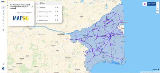
GIS for Smarter Energy Infrastructure

GIS technology plays a critical role in designing, monitoring, and optimizing power grid infrastructure. Through geospatial analysis, utilities can map assets, forecast demand, and enhance system reliability—supporting grid modernization and energy access in growing regions.
Why GIS is Crucial for Power Grid Planning Traditional power infrastructure planning lacks spatial insight. GIS enables utilities to visualize substations, transmission lines, and load centers, ensuring informed decision-making, better outage response, and smarter resource allocation across regions.
GIS Enhances Power Grid Management Through:
Asset Mapping: Recording and tracking the location and condition of grid infrastructure.
Load Forecasting: Using spatial demand data to plan future capacity and prevent overloads.
Risk Assessment: Identifying areas vulnerable to weather disruptions or equipment failures.
Integration of Renewables: Mapping solar, wind, and hydro resources for clean energy planning.
Power Grid Planning with GIS Involves:
Creating transmission and distribution layer maps.
Overlaying weather, terrain, and hazard zones.
Buffering critical facilities (e.g., hospitals) for prioritized energy restoration.
Styling infrastructure by voltage class for visual clarity.
Procedure for Power Grid Mapping and Infrastructure Planning Using GIS
Selecting the relevant power grid data. Import administrative boundary layers for the desired district and fine-tune their styling to improve visual clarity. Add high-voltage transmission lines from the infrastructure dataset. Apply a 100-meter buffer around the selected lines, then use the Merge Polygon tool to combine overlapping areas. Configure attribute merging with 'count' for numerical fields and 'concat' for text. Review and share the map to aid in power grid analysis and planning.
Use Case: Renewable Integration and Grid Expansion GIS helps identify optimal locations for renewable energy projects by analyzing sunlight exposure, wind patterns, and land use, while aligning them with existing grid capacity—enabling smarter, greener energy systems.
Open-source GIS Tools for Grid Mapping Platforms like MAPOG support utility companies with interactive mapping, spatial load balancing, and collaborative planning features. With open access and cloud deployment, these platforms are redefining how power grids are designed and maintained.
Conclusion GIS-based grid mapping ensures smarter, safer energy networks. Buffer tools and spatial planning empower energy providers to design infrastructure that is both resilient and responsive to modern energy demands.
#PowerGridMapping#SmartEnergy#UtilityPlanning#GISPower#GridResilience#SustainableEnergy#GeospatialSolutions#SmartMapping#InfrastructureInnovation#FutureOfEnergy
1 note
·
View note
Text
Dutch utilityplans massive windfarm island
TenneT, the primary electric utility company in the Netherlands, is planning to construct a “windfarm island” in the North Sea. This island would serve as an operational hub for a network of nearby offshore wind farms at a facility that would dwarf any current such centers. The plan, already in its advanced stages, proposes Dogger Bank, 125km (78 miles) off the East Yorkshire coast of England, as a potential location for the wind farm island. Once constructed, the hub would transmit electricity… Dutch utilityplans massive windfarm island syndicated from findqueenslandelectricians.wordpress.com
0 notes
Text
Dutch utilityplans massive windfarm island
TenneT, the primary electric utility company in the Netherlands, is planning to construct a “windfarm island” in the North Sea. This island would serve as an operational hub for a network of nearby offshore wind farms at a facility that would dwarf any current such centers. The plan, already in its advanced stages, proposes Dogger Bank, 125km (78 miles) off the East Yorkshire coast of England, as a potential location for the wind farm island. Once constructed, the hub would transmit electricity… Dutch utilityplans massive windfarm island syndicated from http://ift.tt/2qVvDwT
0 notes
Text
Dutch utilityplans massive windfarm island
TenneT, the primary electric utility company in the Netherlands, is planning to construct a "windfarm island" in the North Sea. This island would serve as an operational hub for a network of nearby offshore wind farms at a facility that would dwarf any current such centers. The plan, already in its advanced stages, proposes Dogger Bank, 125km (78 miles) off the East Yorkshire coast of England, as a potential location for the wind farm island. Once constructed, the hub would transmit electricity...
0 notes
Text
Dutch utilityplans massive windfarm island
TenneT, the primary electric utility company in the Netherlands, is planning to construct a “windfarm island” in the North Sea. This island would serve as an operational hub for a network of nearby offshore wind farms at a facility that would dwarf any current such centers. The plan, already in its advanced stages, proposes Dogger Bank, 125km (78 miles) off the East Yorkshire coast of England, as a potential location for the wind farm island. Once constructed, the hub would transmit electricity… Dutch utilityplans massive windfarm island syndicated from findqueenslandelectricians.wordpress.com
0 notes