#GeospatialSolutions
Explore tagged Tumblr posts
Visit Tumblr Blog
Explore Tumblr blogs with no restrictions, modern design and the best experience.
Last Seen Tumblr Blogs


Fun Fact
Tumblr has been banned in Indonesia for providing people with access to pornographic content.
Text
GIS for Smarter Energy Infrastructure

GIS technology plays a critical role in designing, monitoring, and optimizing power grid infrastructure. Through geospatial analysis, utilities can map assets, forecast demand, and enhance system reliability—supporting grid modernization and energy access in growing regions.
Why GIS is Crucial for Power Grid Planning Traditional power infrastructure planning lacks spatial insight. GIS enables utilities to visualize substations, transmission lines, and load centers, ensuring informed decision-making, better outage response, and smarter resource allocation across regions.
GIS Enhances Power Grid Management Through:
Asset Mapping: Recording and tracking the location and condition of grid infrastructure.
Load Forecasting: Using spatial demand data to plan future capacity and prevent overloads.
Risk Assessment: Identifying areas vulnerable to weather disruptions or equipment failures.
Integration of Renewables: Mapping solar, wind, and hydro resources for clean energy planning.
Power Grid Planning with GIS Involves:
Creating transmission and distribution layer maps.
Overlaying weather, terrain, and hazard zones.
Buffering critical facilities (e.g., hospitals) for prioritized energy restoration.
Styling infrastructure by voltage class for visual clarity.
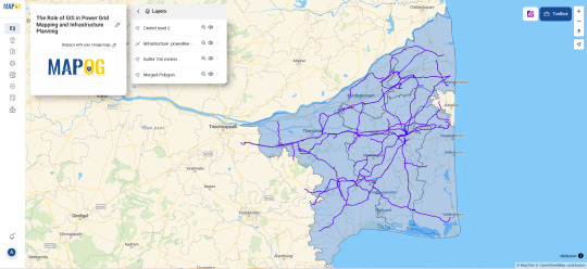
Procedure for Power Grid Mapping and Infrastructure Planning Using GIS
Selecting the relevant power grid data. Import administrative boundary layers for the desired district and fine-tune their styling to improve visual clarity. Add high-voltage transmission lines from the infrastructure dataset. Apply a 100-meter buffer around the selected lines, then use the Merge Polygon tool to combine overlapping areas. Configure attribute merging with 'count' for numerical fields and 'concat' for text. Review and share the map to aid in power grid analysis and planning.
Use Case: Renewable Integration and Grid Expansion GIS helps identify optimal locations for renewable energy projects by analyzing sunlight exposure, wind patterns, and land use, while aligning them with existing grid capacity—enabling smarter, greener energy systems.
Open-source GIS Tools for Grid Mapping Platforms like MAPOG support utility companies with interactive mapping, spatial load balancing, and collaborative planning features. With open access and cloud deployment, these platforms are redefining how power grids are designed and maintained.
Conclusion GIS-based grid mapping ensures smarter, safer energy networks. Buffer tools and spatial planning empower energy providers to design infrastructure that is both resilient and responsive to modern energy demands.
#PowerGridMapping#SmartEnergy#UtilityPlanning#GISPower#GridResilience#SustainableEnergy#GeospatialSolutions#SmartMapping#InfrastructureInnovation#FutureOfEnergy
1 note
·
View note
Text
Protect Your Land with Smart Encroachment Detection!
Safeguarding your land goes beyond ownership—it requires proactive monitoring. With LAMS, detect unauthorized encroachments in real-time using advanced satellite imagery, drone data, and AI-driven analysis. Stay ahead with regular monitoring and ensure your land remains secure!
Know more at https://lamsapp.com/services/land-encroachment-detection
#LandProtection#EncroachmentDetection#SmartLandManagement#LAMS#GISMapping#LandMonitoring#RemoteSensing#LandSurveillance#PropertySecurity#GeospatialSolutions#DroneMapping#SustainableLandUse#SmartLandTech
0 notes
Text
Transforming Aviation: Atom Aviation as a Leading GIS Company in India

In today’s fast-paced world, technology is reshaping industries, and the aviation sector is no exception. At the forefront of this transformation is Atom Aviation, a pioneering GIS company in India that leverages Geographic Information System (GIS) technology to revolutionize operations and enhance decision-making.
What Makes GIS Essential in Aviation?
GIS technology empowers aviation professionals to visualize, analyze, and interpret spatial data with remarkable precision. It’s the backbone of efficient flight planning, air traffic management, and safety protocol development. By using GIS, airlines and drone operators can optimize routes, monitor terrain, and ensure compliance with safety standards.
Atom Aviation: Shaping the Future of GIS in India
As a leading GIS company in India, Atom Aviation offers cutting-edge solutions tailored to the aviation sector. From advanced flight planning and spatial mapping to real-time analytics and drone integration, the company is setting new benchmarks.
Key Highlights of Atom Aviation’s GIS Services:
Flight Planning: Optimizing routes to reduce fuel consumption and operational costs.
Spatial Mapping: Offering topographical insights for airspace management and obstacle detection.
Real-Time Analytics: Providing actionable insights for safer and more efficient operations.
Why Choose Atom Aviation?
Atom Aviation stands out with its commitment to innovation and safety. By integrating GIS with drone technology and AI-driven analytics, the company is redefining how aviation businesses operate. This positions Atom Aviation not just as a service provider but as a trailblazer in India’s GIS and aviation sectors.
Looking Ahead: The Future of GIS in Aviation
The future holds exciting possibilities for GIS in aviation. Emerging trends like 3D mapping, AI-driven predictive analytics, and autonomous drones are set to revolutionize the industry. Atom Aviation is at the helm, embracing these advancements to continue delivering unmatched solutions.
#GISCompanyIndia#GeospatialSolutions#GISMappingIndia#GISInAviation#SpatialDataAnalysis#IndianAviationTechnology#LocationIntelligence#GISProviderIndia#DroneGISMapping#AtomAviationGIS
1 note
·
View note
Text
GeoPackage Vector Tiles
https://medium.com/@geospatialsolutions/geopackage-vector-tiles-f9eef1efe57d
0 notes
Photo

#Ceinsys brings to the table a unique integration between #Engineeringand #Geospatialsolutions for most #infrastructure segments. #Road & #highway See More: https://goo.gl/vURoyU
1 note
·
View note
Text
neo360 | Lepton Software
Optimize your network and reduce customer churn by deploying a vendor-agnostic, and highly engaging platform offered by Lepton Software neo360. Get valuable insights that inspire action. Schedule a demo now - https://lnkd.in/dh82KQKY #LeptonSoftware #Dataintelligence #LocationIntelligence #Geospatialsolutions #NetworkPlanning #Networkoptimization #data #software #network

0 notes
Text
Lider Survey Company in India – Expert Solutions for Accurate Results

In today’s fast-paced world, precise data and accurate surveys are crucial for making informed decisions across various industries, from construction and real estate to agriculture and environmental monitoring. That’s where Atom Aviation comes in. Atom Aviation is a leading provider of advanced drone survey solutions, offering expert services that ensure accurate and reliable results.
Revolutionizing Surveying with Drone Technology
At Atom Aviation, we leverage the power of drone technology to deliver high-quality surveying services. Traditional methods of surveying can be time-consuming, costly, and often prone to errors. With drones, we can gather detailed, high-resolution data in a fraction of the time, covering large areas with minimal disruption. Our drones are equipped with advanced sensors, GPS, and LiDAR technology, which allows us to provide highly accurate mapping, topographical surveys, and volumetric analysis.
Services Offered by Atom Aviation
Aerial Mapping and Photogrammetry Using advanced drone systems, we create detailed 2D and 3D maps of land, providing essential insights for planning, construction, and analysis.
Topographic Surveys Our topographic surveys capture precise elevation data, helping engineers and architects design projects with a clear understanding of the landscape.
LiDAR and Geospatial Data Collection We use LiDAR-equipped drones to gather precise measurements of terrain, even in challenging environments, allowing for accurate land development and environmental assessments.
Agricultural Surveys Atom Aviation offers specialized services for agriculture, using drones to monitor crop health, analyze soil conditions, and optimize field management practices.
Why Choose Atom Aviation?
At Atom Aviation, we understand the importance of accuracy and efficiency in survey projects. Our drone surveys offer several key advantages over traditional methods:
Cost-effective: Drone surveys are faster and less labor-intensive, reducing project costs.
Precise data: With cutting-edge technology, we ensure millimeter-level accuracy in all our surveys.
Timely results: We complete surveys in less time, enabling quicker project turnaround.
Whether you're working on a large construction project or need precise agricultural insights, Atom Aviation offers tailored drone survey services to meet your needs. Our team of experts is dedicated to delivering the best results, ensuring your projects are based on reliable data.
Visit our website to learn more about how Atom Aviation’s drone survey services can support your next project and help you achieve accurate, efficient results.
#LiderSurveyCompany#SurveyServicesIndia#DroneSurveyIndia#SurveyingExperts#LiderSurveyIndia#GeospatialSolutions#AerialSurveyIndia#TopographicSurvey#UAVSurveying#LiDARSolutions#SurveyingTechnology#PrecisionSurveying#SurveyingServices#LandSurveyIndia#MappingSolutionsIndia
1 note
·
View note
Text
Empower Your Business with Custom Salesforce Solutions from CyberSWIFT!
Looking to streamline your operations and boost productivity? Our custom Salesforce solutions are designed to fit your business needs, helping you achieve greater efficiency and better customer engagement.
#SalesforceDevelopment#SalesforceSolutions#SalesforceConsulting#CustomSalesforce#SalesforceIntegration#SalesforceCRM#SalesforceExperts#SalesforceDeveloper#SalesforceAutomation#SalesforceCustomization#SalesforceServices#SalesforceConsultants#CRMDevelopment#CloudSolutions#SalesforcePlatform#GISSoftware#GeospatialTechnology#GISMapping#GeographicInformationSystem#LocationIntelligence#SpatialAnalysis#GISSolutions#MappingSoftware#GISDevelopment#GeospatialSolutions#GISConsulting#GISApplications#GISInnovation#GISData#GeospatialMapping
0 notes
Text
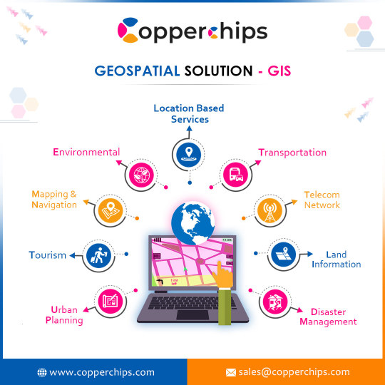
Geographic information systems (GIS) and mapping
Geospatial Solutions in maps refer to specialized services for geographic information systems (GIS) and mapping. These services typically focus on providing custom solutions for businesses and organizations that require advanced mapping capabilities and data analysis.
0 notes