#coso volcanic range
Photo
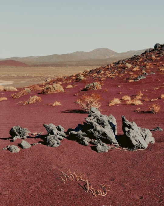
Coso Range, California. US. photo by Miguel A. Estrada
398 notes
·
View notes
Text
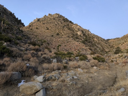
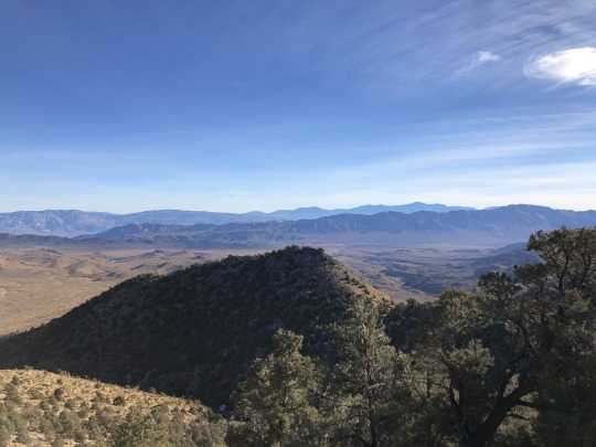
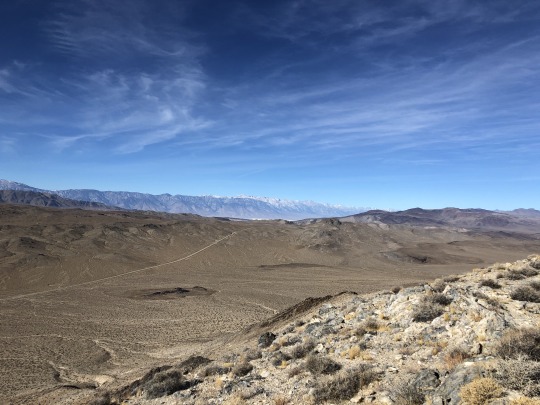
Coso Range, Ophir Mountain & Darwin Benchmark

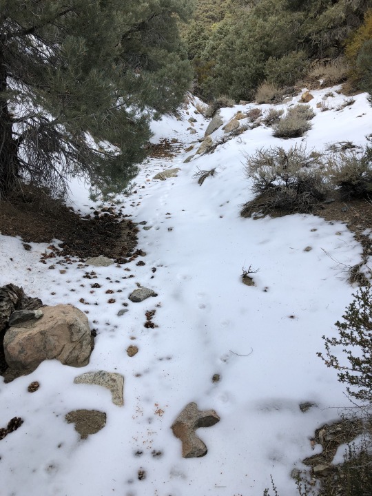
Feeling a little cooped up at home, I drove to the desert and spent a January day rambling solo through the desert. I later learned that one of the big mountains I scrambled up might have been on military property, but I can’t say for sure. I was a little out of it all day because I hardly slept the night before since the middle portion of my sleeping pad deflated. I woke up before sunrise and started off through the sagebrush along Lower Centennial Flat.
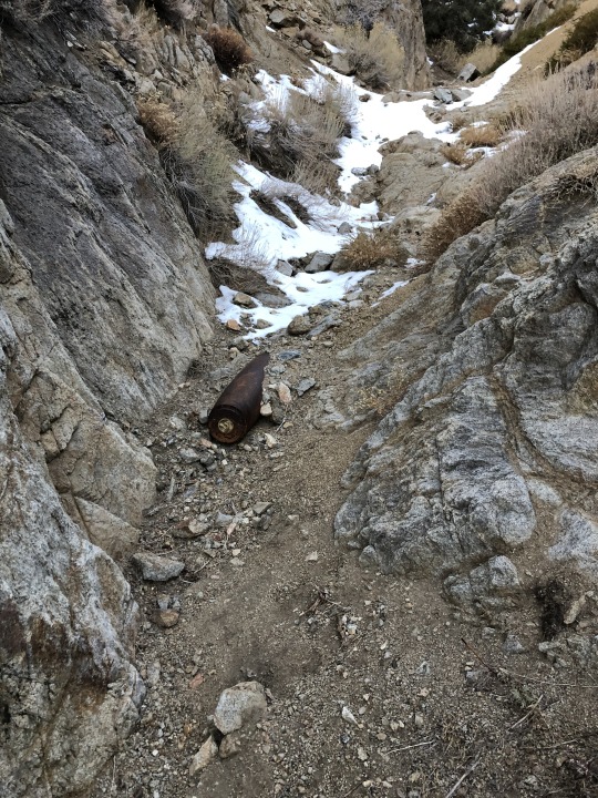
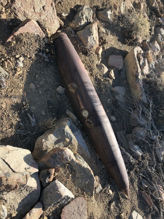
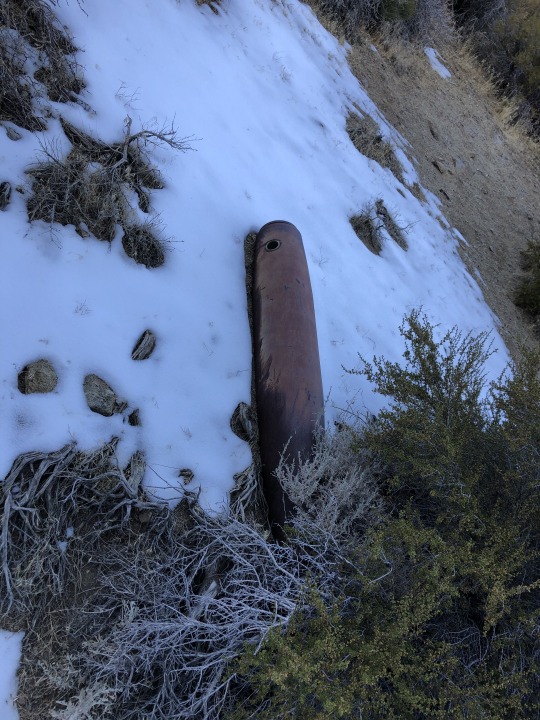
I found a unexploded ordinance sitting right in the middle of a wash. This was the first of several that I came across that day. I tried to climb above it, but in the end accidentally kicked some small rocks down on top of it. In retrospect that was not so smart of me.

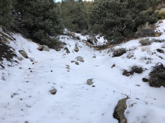
-Snowy Gully


-Sierra Nevada


-Coso Volcanic Field

-Southern Sierra Nevada
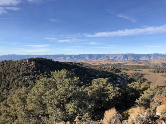
-Mt Langley and Mt Whitney
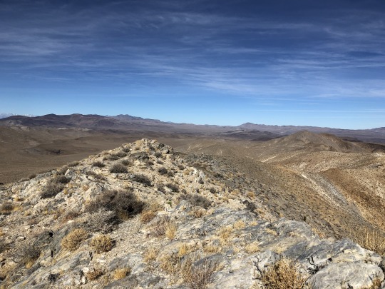
There was a building on the summit. I didn't see anyone else around, but the road which leads up here seems to get some traffic. I snapped a few photos of the surroundings then started back down.

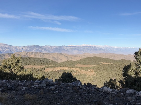
-Inyo Mountains

-Death Valley
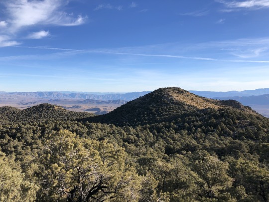
-Telescope Peak and Maturango Peak
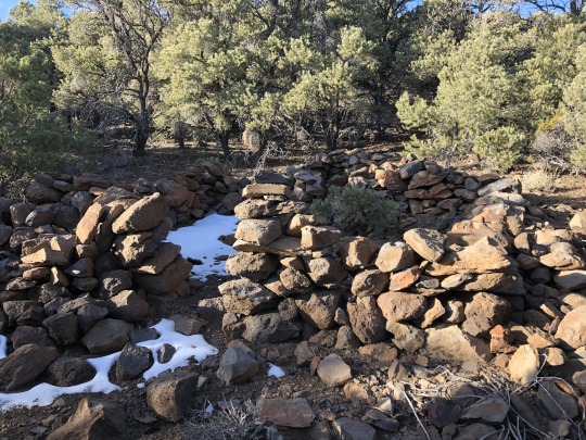
-Abandoned rock structure

-Owens Valley

-New York Butte, Pleasant Point, Cerro Gordo and Conglomerate Mesa
-UXO

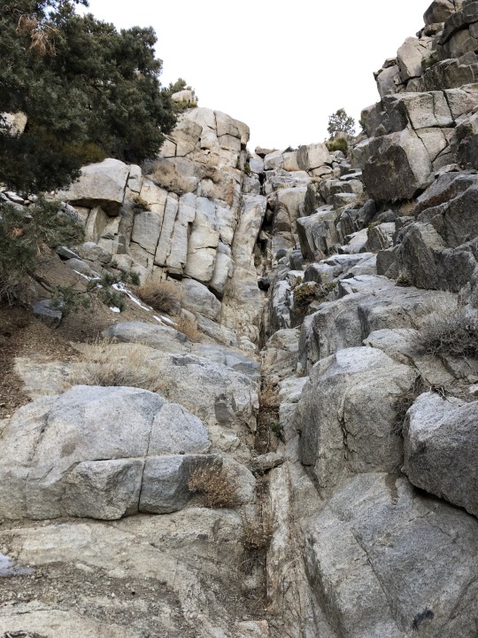
I decided to take a different wash on my way back down.
-Shiny object

-UXO
-UXO
-Descent wash


-Joshua Trees


-Wild horses

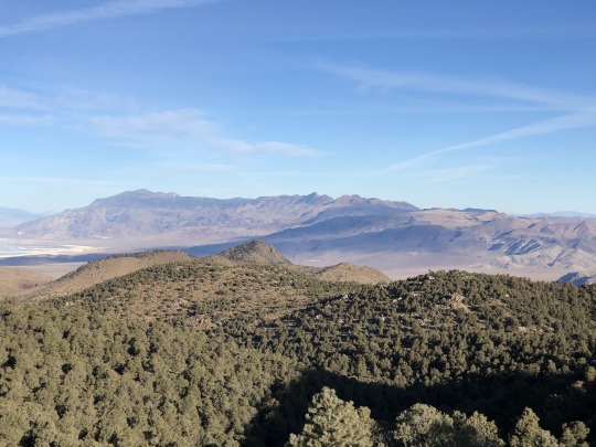
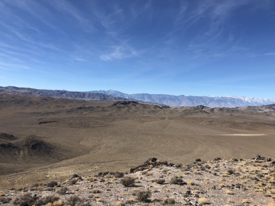
I stumbled back to my car and drove east a little bit to climb some bonus peaks. First I scrambled up Ophir Mountain from a dirt road to the north.
-Panamint Butte, Towne Benchmark & Pinto Peak

-Wildrose Peak, Rodgers Peak, Bennett Peak & Telescope Peak

-Darwin
-Coso Peak
-Sierra Nevada
-Inyo Mountains & Nelson Range
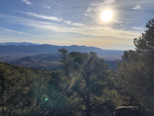
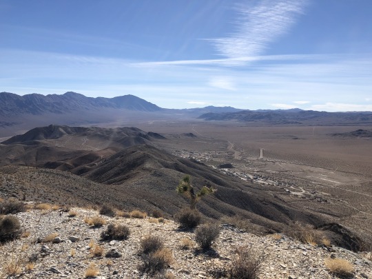
I then drove north for a short distance to the southern side of Darwin Benchmark. It took me only a few minutes to walk to the top.
-Panamint Valley

-Darwin Plateau

-Low Centennial Flat
-Ophir Mountain & Coso Peak

-French Madame and Maturango Peak
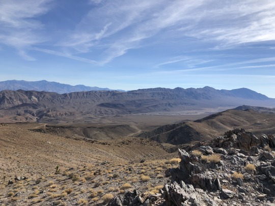
-Rock Structures

-Old mine

From there I decided to drive to Lone Pine to see if the road to the Whitney Portal was open.

The rangers at the visitor center knew nothing, so I drove up to the portal to see for myself. I was able to drive to the top of the large switchback. There was ice on the road so 4WD and good tires was nice to have. The gate was closed at 7,549 ft, but I felt this was good enough for me to hike Thor Peak the next day. I reserved a motel room in Lone Pine and finally got some needed rest.
2 notes
·
View notes
Text
Emptying the cliptray on the new phone. ....
1. 6,147 views|Mar 3, 2019,9:14 am 200,000 People Go Into California's Volcanic Hazard Zones Every Day Robin AndrewsContributor Science A scenic view of Mount Shasta in Northeast California (Carol M. Highsmith/Buyenlarge/Getty Images) California isn’t exactly known for its volcanic activity. In the minds of most, it’s a place where tectonic forces battle it out, gearing parts of the state up for a dangerous and perhaps catastrophic earthquake. Things, however, aren’t quite so uniform. The United States Geological Survey published their National Volcanic Threat Assessment (NVTA) toward the end of 2018. It found, among other things, that there are 161 volcanoes in the US that have erupted in the last 12,000 years or so at least once, which makes them all “active.” Out of that 161, 12 reside in California, from those in the four-volcano complex in the Long Valley volcanic region to the lava dome-riddled Salton Buttes area. There is no sign in any way that any of these volcanoes are going to erupt in any manner anytime soon. Nevertheless, these volcanoes are all classified as “active” which means that the USGS is extremely keen on monitoring them. To wit, the agency, in conjunction with the California Geological Survey and the California Governor’s Office of Emergency Services, has released a new report on the hazards presented by California’s volcanoes. A headline-worthy finding is that 199,235 people live or work in, or otherwise pass through, one of California’s volcanic hazard zones every single day. This may come as a shock to many, and the USGS acknowledge that. Right at the start of their report, the authors explain that volcanic eruptions occur in the state as frequently as the largest earthquakes on the San Andreas Fault, and yet they are not acknowledged in the same manner. I suspect this is because small earthquakes happen all the time there, serving as reminds of what is to come, whereas the state’s volcanoes remain silent for considerably long periods of time, where they fade into obscurity. Volcanism has most certainly not been confined to the ancient past, though. The most recent occurring during the First World War: the 1914-1917 eruption of Lassen Peak in the state’s north.In the last 1,000 years, at least 10 eruptions have taken place in California. Significant eruptions and notable quakes are roughly as commonplace as each other. No-one can predict when a future eruption will occur, nor specifically how it will erupt. Each volcano is very different from the next, meaning you cannot generalize or make any sweeping statements. Saying that, the USGS gives a very approximate estimate, based on the eruption rates in the state, that there is a 16% chance that a small-to-moderate eruption will take place in the next 30 years. This, per the report, is a similar forecast to a magnitude 6.7 or greater quake taking place in the San Francisco Bay region. Map showing volcanoes or volcanic centres in California that are of a moderate, high or very high threat, as determined by the recent National Volcano Threat Assessment report (2018).USGS The state contains several volcanoes that rank anywhere between a “moderate” threat (e.g. Coso volcanic field) to a “very high” one (e.g. Mount Shasta). These categories don’t forecast when an eruption will occur; rather, they denote the volcano’s individual potential to cause damage to infrastructure, transportation, societies, the economy and so on, based on their past eruptive history. “Very high” is obviously the most extreme category, but that doesn’t mean in any way that this volcano is guaranteed to explode to life and kill people in the future. As I outlined here, assuming a volcano does erupt again in the future, explosivity isn’t the be-all-and-end-all factor here; volcanoes have a huge range of hazards, from effusive, never-ending lava flows like those from Hawaii’s Kilauea to rapidly moving, concrete-like ash-filled slurries known as lahars, as typified by Washington state’s Mount Rainier. Sure, explosive eruptions produce superhot, superfast pyroclastic density currents, but they might not be as deadly as those lahars if a far smaller population lives in the volcano’s shadow. They could, however, produce sustained ash plumes that could down airplanes – and, as it happens, as many as 1,000 passenger jets fly over Californian volcanoes every single day, according to the report. The point, really, is that describing volcanic hazards is a decidedly complex endeavour. Each volcano plays by its own rules, and the USGS and its colleagues elsewhere have done a stellar job of trying to classify the threat potential of each of California’s idiosyncratic geological troublemakers. Instead of focusing on highly specific future eruption scenarios, it’s probably best to focus on the eight volcanic hazard zones that the report has determined need particular attention. California’s volcanic hazard zones, defined partly by the specific volcanic eruptive products they may face in the future.USGS The stats attached to each hazard zone speak for themselves. Take Mount Shasta, a tall stratovolcano near the Oregonian border, for example. This volcano, with a history of explosive activity, has a considerable hazard zone: it overlooks a population of 103,885 people, has 37.3 million vehicles pass by it every year, and has 410 planes fly over it each day. The mercurial Long Valley volcanic region, as another example, features a population of 63,523, has 16.5 million vehicles going through it every year, and has 1,220 planes flying over it every 24 hours. A moderate eruption at either could cause pandemonium. It isn’t just the local population that’s taken into account, by the way. The report also assesses the potential regional effects of an eruption, either from being directly impacted by the volcano’s fury or via indirect knock-on effects. From transportation corridors and water supply networks to the electrical grid and the agricultural sector, eruptions could disrupt many key aspects of society depending on where and how they occur. Again, no specific forecasts can be made, but it’s noteworthy that plenty of infrastructure sits in these volcanic hazard zones. Three major water projects do, as do 75 hydroelectric power plants. About 40 percent of California’s timber comes from these hazard zones, and 330,000 acres of cropland fall within their purview. The risks are real. An eruption in the state may end up being a damp squib, so to speak, but it could also be devastating enough to hugely disrupt California in a plethora of ways. Such a paroxysm will, as the report makes clear, require a “multi-jurisdictional response effort.” It cannot be stressed enough times that this report, like the NVTA, is not a prophetic document. It does not claim to know when or how these volcanoes would erupt. None of these volcanoes are currently showing any signs of an impending eruption of any kind, and even if they did, we would have days and perhaps weeks of warning signs. There’s even a chance that some many never erupt again. Some of you may worry a little that the Long Valley Caldera – a so-called supervolcano – is on this list as part of the expansive Long Valley volcanic region, and you may not take my cautious words to heart. Don’t believe the hype. The 760,000-year-old pit recently caught the media’s attention as a fearsome beastie, because a) a study revealed it contained 1,000 cubic kilometres (240 cubic miles) of magma, and b) because many didn’t realize a scary-sounding, bona fide supervolcano was hanging out in California. As I’ve explained here, though, a “supervolcano” isn’t what you think it is: just because it erupted in a cataclysmic way once, doesn’t mean it’ll ever do so again. In fact, that aforementioned study pointed out that despite having an impressive cache of magma, only 27 percent is molten at present, far shy of the 50 percent needed to cause an eruption. Nevertheless, all things considered, hazards – uncertain but present – exist when it comes to California’s underappreciated volcanoes. That’s why the USGS concludes this report by calling for greater monitoring and greater cooperation between scientific agencies and local authorities. Few would argue that’s a bad idea. This, it seems, includes Congress, who just authorized the USGS to finally set up a nationwide early warning system for America’s volcanoes, something that will make everyone, including Californians, safer. Robin AndrewsContributor Robin George Andrews is a doctor of experimental volcanology-turned-science journalist. He tends to write about the most extravagant of scientific tales, from eruptions…Read More Loading ... Also on Forbes Science Civic Nation BrandVoice: 5 Tips For School Counselors To Recharge And Better Serve Their Students SCIENCE#WhoaScience 'Sealioning' Is A Common Trolling Tactic On Social Media--What Is It? © 2019 Forbes Media LLC. All Rights Reserved. AdChoicesPrivacy StatementTerms and ConditionsContact UsJobs At ForbesReprints & PermissionsForbes Press RoomAdvertise 2. https://www.instagram.com/p/BupGfHAnv64/?hl=en 3. https://www.instagram.com/p/BuV8FM5AOxI/?hl=en 4. https://goo.gl/images/ebHjRN 5. https://goo.gl/images/24PQiN 6. https://goo.gl/images/ufJSDG 7. https://goo.gl/images/QFBdb4 8. https://goo.gl/images/2XEu3n 9. https://goo.gl/images/xpS3bQ 10. https://peopledotcom.files.wordpress.com/2019/03/taylor-swift-3.jpg 11. https://goo.gl/images/MEm7tu 12. https://goo.gl/images/wU81Do 13. https://pixel.nymag.com/imgs/daily/selectall/2016/07/18/18-taylor-swift.w330.h330.jpg 14. https://goo.gl/images/KcgmHP 15. https://goo.gl/images/GqVxKq 16. https://yt3.ggpht.com/a-/AAuE7mAVKfGtqiRSJR0deLwUc6GKjHzZH0ufQD3Byw=s900-mo-c-c0xffffffff-rj-k-no 17. https://goo.gl/images/pczPMh 18. https://www.google.com/search?q=taylor+swift&oq=taylor&aqs=chrome.0.69i59j69i57j35i39j0j69i60l2.2368j1j9&client=ms-android-mpcs-us-revc&sourceid=chrome-mobile&ie=UTF-8#scso=_D6iCXOHeH6yO5wK424nAAg14:1864.761962890625.142822265625.6190185546875.90478515625.047607421875.8095703125.5714111328125.761962890625.5714111328125.7142333984375.2857666015625.142822265625.047607421875.238037109375.6190185546875.238037109375.4285888671875.6190185546875.3333740234375.09521484375.7619018554688.3809814453125.8571166992188.5238037109375.4285888671875.2857055664062.952392578125.6190185546875.23809814453125.4761962890625.1428527832031.8095092773438.2380981445312.1428833007812.6190490722656.8571472167969.095237731933594 19. OVERVIEW TOP STORIES LISTEN SONGS VIDEOS ALBUMS MOVIES AND TV SHOWS MORE PEOPLE 1 of 8 Top stories Taylor Swift's accused stalker arrested for breaking into her apartment building Page Six - 1 day ago Taylor Swift Applauded for Toting Gunshot Gauze The Blast - 9 hours ago Taylor Swift's Homestead stalker is 'violent predicate felon,' prosecutor says 5 hours ago NBC News Taylor Swift stalker arrested — again — for breaking into her NYC home 1 day ago Page Six Taylor Swift's accused stalker scowls on his way to arraignment 21 hours ago ABC News Suspected stalker allegedly breaks into Taylor Swift's apartment again 1 day ago PEOPLE.com Taylor Swift Says She Had to Learn to 'Stop Hating Every Ounce of Fat' on Her Body 1 day ago Aol Taylor Swift's stalker arrested for breaking into her home -- for the second time 23 hours ago E! News Taylor Swift Home Intruder Arrested After Break-In, 2nd Time in a Year 1 day ago Page Six Taylor Swift's accused stalker arrested for breaking into her apartment building 1 day ago CBS New York Taylor Swift’s Accused Stalker Arrested At Her Manhattan Home 23 hours ago TMZ.com Taylor Swift Burglar Makes Return Visit, Busted Again 1 day ago PEOPLE ALSO SEARCH FOR Roger Alvarado and Taylor Swift Taylor Swift home broken into Taylor Swift mother cancer Listen YouTube Play Music Spotify Pandora Deezer iHeartRadio TuneIn About Taylor Swift Image result for taylor swift Image result for taylor swift Image result for taylor swift Image result for taylor swift Image result for taylor swift Image result for taylor swift Image result for taylor swift Image result for taylor swift Image result for taylor swift Image result for taylor swift Image result for taylor swift View all taylorswift.com DescriptionTaylor Alison Swift is an American singer-songwriter. As one of the world's leading contemporary recording artists, she is known for narrative songs about her personal life, which has received widespread media coverage. Wikipedia HER STORY Life and career highlights Start story Born: December 13, 1989 (age 29 years), Reading, PA Height: 5′ 10″ Movies and TV shows: The Giver, The Lorax, Cats, Valentine's Day, Journey to Fearless, More Parents: Scott Kingsley Swift, Andrea Swift Show less Top results 20. Top stories Taylor Swift's accused stalker arrested for breaking into her apartment building Page Six - 1 day ago Taylor Swift Applauded for Toting Gunshot Gauze The Blast - 9 hours ago Taylor Swift's Homestead stalker is 'violent predicate felon,' prosecutor says 5 hours ago NBC News Taylor Swift stalker arrested — again — for breaking into her NYC home 1 day ago Page Six Taylor Swift's accused stalker scowls on his way to arraignment 21 hours ago ABC News Suspected stalker allegedly breaks into Taylor Swift's apartment again 1 day ago PEOPLE.com Taylor Swift Says She Had to Learn to 'Stop Hating Every Ounce of Fat' on Her Body 1 day ago Aol Taylor Swift's stalker arrested for breaking into her home -- for the second time 23 hours ago E! News Taylor Swift Home Intruder Arrested After Break-In, 2nd Time in a Year 1 day ago Page Six Taylor Swift's accused stalker arrested for breaking into her apartment building 1 day ago CBS New York Taylor Swift’s Accused Stalker Arrested At Her Manhattan Home 23 hours ago TMZ.com Taylor Swift Burglar Makes Return Visit, Busted Again 1 day ago PEOPLE ALSO SEARCH FOR Roger Alvarado and Taylor Swift Taylor Swift home broken into Taylor Swift mother cancer Listen YouTube Play Music
0 notes
Photo
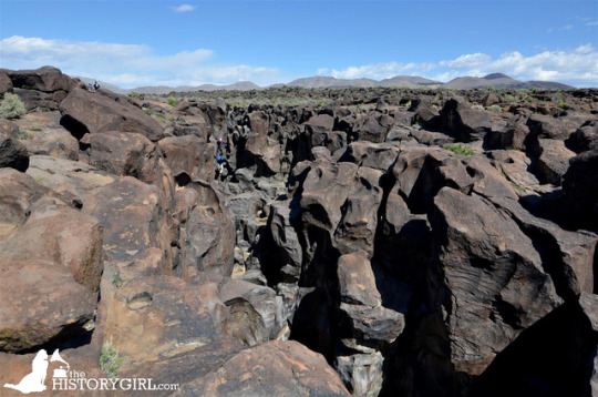
I decided to go through some photos from last year when I went to Nevada and #California. I never posted my visit to Fossil Falls (a dry waterfall), which is managed by the Bureau of Land Management (@mypubliclands). This unique geological feature is located in the Coso Range of California. Volcanic activity in the mountain range, wind, and meltwater from glaciers during the last Ice Age, in the nearby Sierra Nevada, played a role in the creation of the falls. All the lava flows at Fossil Falls are basaltic. The erosion found at Fossil Falls was formed by the youngest glacial runoff, called the Tioga, about 10,000 to 20,000 years ago. There are also large, perfectly circular penetrations in the #basalt. These are erosional features called potholes. From the photo of the falls, it is hard to get an idea of the depth and just how unique this area is, but if you look closely, you can see people climbing down the #falls. Swipe ▶️ Not far from the falls is a mound called Red Hill, which is a cinder cone. It is believed that the #volcano last erupted about 10,000 years ago with evidence suggesting a more recent, relatively minor eruption on the northwest flank of the volcano. #ca #cahistory #historygirl #SpreadTheHistory #bureauoflandmanagement #californiagems #publiclands #optoutside #geology #findyourpark #fossilfalls #travelblog #travelblogger #blog #blogger #beautiful #americathebeautiful #explore #exploreca #jerseycollective #igersca #dryfalls #cindercone #lava #redhill (at Fossil Falls) https://www.instagram.com/p/BnhysuCBnnR/?utm_source=ig_tumblr_share&igshid=14gn3f00m4pjb
#california#basalt#falls#volcano#ca#cahistory#historygirl#spreadthehistory#bureauoflandmanagement#californiagems#publiclands#optoutside#geology#findyourpark#fossilfalls#travelblog#travelblogger#blog#blogger#beautiful#americathebeautiful#explore#exploreca#jerseycollective#igersca#dryfalls#cindercone#lava#redhill
0 notes
Last Seen Blogs

laalpacaa
La Alpaca
laalpacaa
La Alpaca

kiky2014
제목 없음

ashlynnstyx-blog
Crowe Art/Literature

soshi-byuntae
Tsundere Stark