#dellbridge islands
Text
The Road to Cape Evans
This is a crosspost from twirlynoodle.com/blog. If you're reading it in beta mode on NeoTumblr, the remote-hosted images won't show up, so please either turn off beta or see it at the original location, linked above. Enjoy!
Having done Sea Ice training at last, I was clear to head out on snowmobile. My coordinator’s intent had been to do a ‘shakedown’ one day – a practice run, to get used to the vehicles, how to load and tie down the sledge, a chance to get things wrong when it doesn’t really matter – and go to Cape Evans the next, but the morning of the shakedown she said ‘It’s a beautiful day, let’s combine the two.' Thus was initiated a de facto rule of my month in Antarctica: One Must Only Ever Go To Cape Evans By Surprise. I ended up going three times, all by surprise, while every excursion that had been planned, even the night before, fell through.
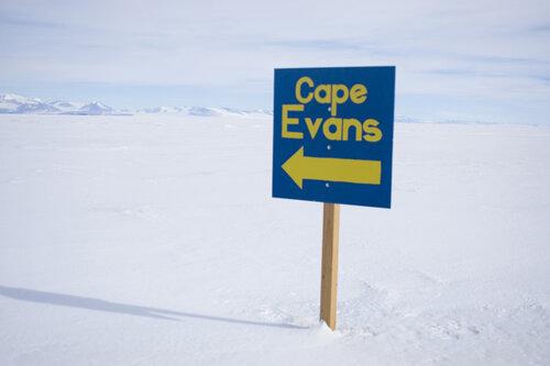
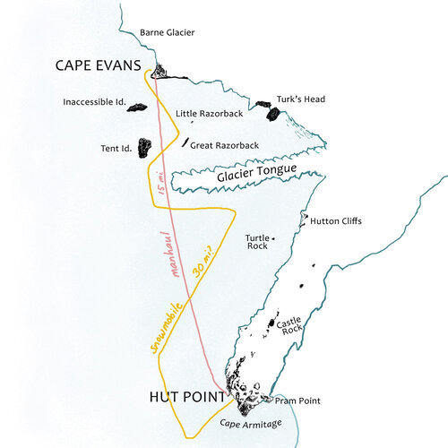
Having been the headquarters of the Terra Nova Expedition, Cape Evans was obviously central to my research and the most important location for me to visit: I’m going to be drawing people doing stuff there for the next decade, probably, and I need to be able to place myself in that space to depict it truthfully. The hut itself is copiously documented, and while dropping in there was obviously valuable to me, the urgent holes in my knowledge were the less photogenic but no less important surroundings of the hut. How far was it to walk up Wind Vane Hill? How far to the Ramp? What was the Ramp? What did the named landmarks between Cape Evans and Hut Point look like, and how did they relate to one another? There was a lot of travelling done over that route – perhaps not quite as frequently as you’d visit the grocery store, but it needs to have that degree of familiarity.
So when we set off on a bright and amazingly balmy November morning, aside from learning the basic practicalities of snowmobile driving, I was keen to document as much of that route as possible.
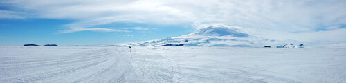
You can’t see Mt Erebus from McMurdo, but I knew from Sea Ice training that only a little way out on McMurdo Sound, the Ross Island panorama comes into view. Once we’d made our turnoff onto the main road and had a clear shot of our objective, I captured it.

A little further on, I got one facing the other direction. This is what you would have seen any time you were setting off for a grand adventure to the south.

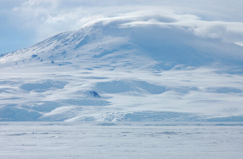
Once clear of Arrival Heights, I got a panorama of the whole of Erebus Bay, with several features I was finally seeing for the first time. Probably the biggest surprise of this trip was finding out just how low Glacier Tongue was. When you see it on a top-down map, or a satellite photo, it’s a hugely prominent feature, but unless you’re very near to it, it is perfectly possible to look right over it to what’s beyond.
Here we were further into the bay than the usual route would have been, but it means we got a better view of the Hutton Cliffs than we would have done otherwise. They are not so much cliffs as hills which, between them, create a cliff of ice and snow. In the frustration of waiting for the sea ice to freeze and allow them back to Cape Evans, the Terra Nova men frequently discussed alternate overland routes back, often starting up the Hut Point Peninsula and going down the slope north of the Hutton Cliffs, so it’s nice to see what they meant.

As we approached Glacier Tongue, the ice effects on Erebus really started to shine. The Sea Ice Master had previously been a mountaineer, and the other person training with me was a skier; when the latter saw how much ice was visible under the snow on Arrival Heights, he commented on the bad skiing. “Yeah, there’s a lot of bad skiing in Antarctica,” the Master replied, quite a historically relevant observation from someone with plenty of expert first-hand experience.
If you look closely, just under the ‘horizon’ line at the base of the slope is a line of undulations that cross the image. These are the saw teeth of Glacier Tongue, the top of which forms the apparent horizon. You see, quite low!

The road took us around the tip; this was the closest I got, but it was close enough to see the height, and how the drifted snow to leeward would provide a ramp from which to climb onto the firmer ice. This was about as far south as the Terra Nova got, when scouting a location for the hut in January 1911, and they weighed up building the hut here vs. on solid ground at Cape Evans. The latter was considered the more sensible option, and rightly so, for only a couple of months later, the end of Glacier Tongue broke off in a big swell and floated out to sea!
From here you get a million-dollar view of the ice falls down Erebus. Reading Cherry-Garrard’s description of them in Worst Journey, after seeing them in person, I have to give him full marks for descriptive power.
Here are the southern slopes of Erebus; but how different from those which you have lately seen. Northwards they fell in broad calm lines to a beautiful stately cliff which edged the sea. But here—all the epithets and all the adjectives which denote chaotic immensity could not adequately tell of them. Visualize a torrent ten miles long and twenty miles broad; imagine it falling over mountainous rocks and tumbling over itself in giant waves; imagine it arrested in the twinkling of an eye, frozen and white. Countless blizzards have swept their drifts over it, but have failed to hide it. And it continues to move. As you stand in the still cold air you may sometimes hear the silence broken by the sharp reports as the cold contracts it or its own weight splits it. Nature is tearing up that ice as human beings tear paper.

All the schemes for finding an overland route to Cape Evans had to contend with crossing these ice falls, and none could think of how to do it. So the sea ice it had to be.
I have been directing all your attention to the view to the right of us, but there are some interesting things to the left as well. Once we pass Glacier Tongue we are almost alongside Tent Island. I have no photos from this end of Tent Island because the road was horribly chewed up around here so all our concentration was on ploughing through, but here is one looking back at it.

Tent Island’s neighbour is Inaccessible Island, named for its steep slopes affording no access. I was surprised how big it was, something I struggled to capture on camera. Having spent many hours of my childhood on I-15, it reminded me of nothing so much as the top of a mountain in the Mojave, lopped off and stuck in the snow. Some of my photos from Cape Evans give a proper sense of scale, but seeing it end-on shows why it was called ‘inaccessible.’

This is also a good vantage point for Great and Little Razorback. They are aptly named: both are a straight and narrow with a very sharp ridgeline. Great Razorback is the larger of the two; Little Razorback is very wee indeed.

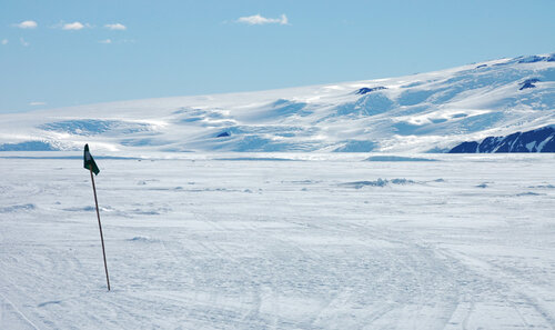
While on the subject of scale, Erebus was always a problem. It never turned up as large in a photo as it seemed to be in real life. The trouble is, trying to get all of it in one shot, you have to zoom so far out that it is inevitably small in the frame. This is more what it felt like to be at the foot of Erebus:
We’re nearly there! I’ve seen an awful lot of the Barne Glacier as seen from Cape Evans; the pieces were in front of me now, and I knew that with only a little change in parallax, Cape Barne would slide behind the glacier face and then we’d be home.

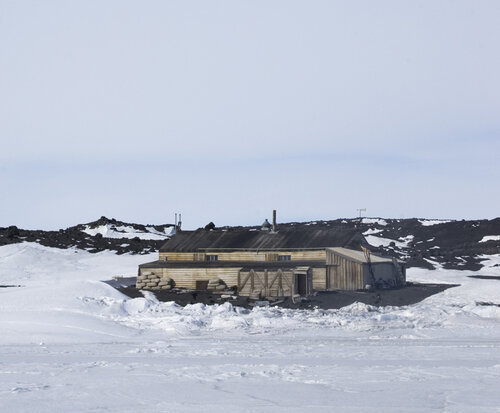
Finally the road rounded a low promontory of blobby lava, and it came into view for the first time:

. . . And seeing it here, in its full setting, in 3D, I realised properly how this is just a shed in the middle of nowhere, and that, for all the stories it contains, it is so very very small, in a way I had never imagined.
But as I pulled up to the snowmobile parking area just offshore, it still felt like coming home.
#antarctica#cape evans#travel#history#polar exploration#mount erebus#sea ice#snowmobiling#usap#united states antarctic program#dellbridge islands#erebus glacier tongue#seals#weddell seals
52 notes
·
View notes
Last Seen Blogs

drkvp123
제목 없음

loveforeveri
Not typical Tumblr girl

smartsdeal4u
Smart Deals For You
vicquemare
REACH & FLEXIBILITY