#dronetechnology
Explore tagged Tumblr posts
Visit Tumblr Blog
Explore Tumblr blogs with no restrictions, modern design and the best experience.
Last Seen Tumblr Blogs


Fun Fact
Tumblr.com is the 103rd most visited website in the world.
Text

#agriculture drone#dronetechnology#uav#farmtech#agritech#sprayingdrone#farmingdrone#dronepilot#spray parts#droneparts
2 notes
·
View notes
Text
Trump shooter flew drone over fairgrounds
#donaldtrump#dronecameras#droneindustry#droneinnovation#dronenews#dronephotography#droneracing#droneregulations#dronereviews#drones#dronetechnology#Trump2024#Trumpadministration#Trumplegacy#Trumpmedia#Trumpnews#Trumppolicies#Trumppresidency#Trumprally#Trumpsupporters
2 notes
·
View notes
Text
Emerging Uses of UAVs in the Role of Public Safety – ePropelled
Discover how UAVs are transforming public safety through enhanced surveillance, search and rescue, disaster response, and emergency management operations.
#UAV public safety#drones in emergency response#UAVs for law enforcement#public safety drones#drone surveillance#search and rescue UAVs#UAV technology in disaster response#emergency drone use cases#UAV integration in public safety#unmanned aerial vehicles in policing#UnmannedAerialVehicle#UAV#Drones#PublicSafety#EmergencyResponse#SearchAndRescue#DisasterResponse#DroneTechnology#UAVInnovation#LawEnforcement#SmartSurveillance#ePropelled#ePropelled Systems#ePropelled Solutions
1 note
·
View note
Text

Engineered for agri-tech innovation, our precision drone platforms enable real-time field data collection, crop health analysis, and automated monitoring — all powered by advanced IoT hardware and sensor integration. Explore how we help agritech businesses accelerate product development at www.auckam.com
#AgriTech#PrecisionAgriculture#DroneTechnology#IoTHardware#EmbeddedSystems#SmartFarming#SensorIntegration#CropMonitoring#AgriculturalInnovation#EngineeringSolutions#Auckam#ProductDevelopment#AgriIoT
0 notes
Text
#DroneTechnology#MotorControl#Innovation#AerospaceEngineering#PrecisionEngineering#TechAdvancements#powerelectronics#powermanagement#powersemiconductor
0 notes
Text

Revolutionizing Farming with Drone Technology!
Say goodbye to traditional farming hassles! Introducing [Your Company Name] Agriculture Drone Services – the future of precision farming.
✅ Crop Health Monitoring ✅ Pesticide & Fertilizer Spraying ✅ Aerial Mapping & Survey ✅ Time & Cost Efficient
📍 Accurate. 🌱 Eco-Friendly. 💸 Saves Time & Labor.
👨🌾 Whether you're a small-scale farmer or manage vast acres, our drone solutions help you make smarter, faster, and more sustainable decisions.
For more information visit: https://bit.ly/3VP62Ht
#AgriDrones#DroneFarming#PrecisionAgriculture#SmartFarming#AgriTech#FarmTech#DroneSpraying#CropMonitoring#AerialSurvey#FarmingInnovation#SustainableFarming#DroneServices#ModernFarming#AgriSolutions#DigitalFarming#TechInAgri#FarmAutomation#YieldBoost#FarmingFuture#RemoteSensing#DroneMapping#AgroDrone#FarmDrone#AgriDroneServices#NextGenFarming#DroneTechnology
0 notes
Text

Techno Track 2K25 at SIRT Bhopal - Print Media
Tech Meets Innovation!
EX Dept proudly presents Techno Track 2K25, graced by esteemed Chief Guest Shri Rakesh Shukla, Cabinet Minister of New and Renewable Energy, and distinguished speakers Dr. Ajay Kumar Choubey and Mritunjoy Shekhar Saini, sharing insights on Drone and Robotics Technology!
0 notes
Text

Unlock precision like never before with our Drone Mapping Services in California! 🛰️📍 At Birds Eye Aerial Drones, we deliver high-resolution maps and data to power smarter decisions for construction, agriculture, and land surveying. Accuracy from above—trusted on the ground. 🚁📊
Visit: https://birdseyeaerialdrones.com/ Call: (619) 886-0100
#BirdsEyeAerialDrones#DroneMappingCalifornia#SurveyingSolutions#DroneTechnology#ConstructionMapping#AgricultureTech#CaliforniaDrones
0 notes
Text
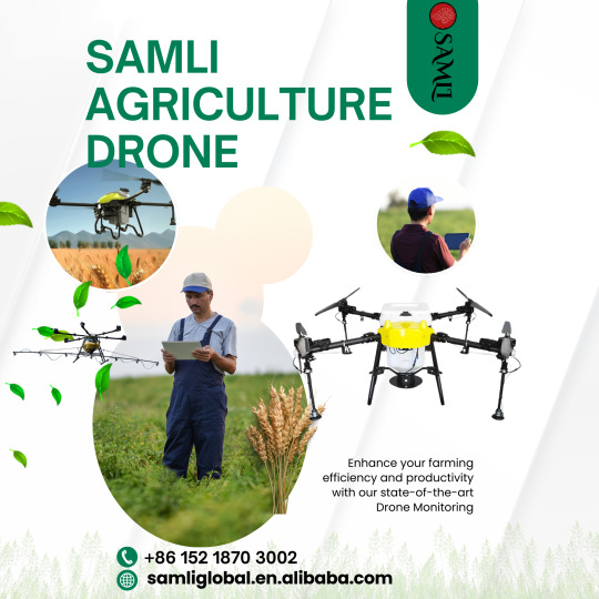
samli drones
🌾 Farming Innovation with Rantizo Drones 🌍 Rantizo is making a big impact in global agriculture with their state-of-the-art crop spraying drones. By providing precision spraying, reducing chemical use, and supporting sustainable farming practices, Rantizo is helping farmers around the world improve efficiency and sustainability. 🌱
#PrecisionFarming#SustainableFarming#AgricultureTech#DroneTechnology#FarmTech#SmartFarming#AgTech#RantizoDrones#CropSpraying#InnovationInAg#FarmAutomation#AgricultureInnovation#DronesInAg#FutureOfFarming#SustainableAgriculture#FarmingTechnology#FarmProductivity#DroneFarming#AgriBusiness#GreenFarming#TechInAgriculture#AgriTech#DroneSpraying#GlobalFarming#TechForGood#EcoFriendlyFarming#Rantizo
0 notes
Text

🌾 Farming Innovation with Rantizo Drones 🌍 Rantizo is making a big impact in global agriculture with their state-of-the-art crop spraying drones. By providing precision spraying, reducing chemical use, and supporting sustainable farming practices, Rantizo is helping farmers around the world improve efficiency and sustainability. 🌱
Store link: https://samliglobal.en.alibaba.com/
Zhongshan Samli Drones Co. Ltd

CONTACT US
WhatsApp: +86 152 1870 3002
We chat: Samli 2022
mail address: [email protected]
#PrecisionFarming#SustainableFarming#AgricultureTech#DroneTechnology#FarmTech#SmartFarming#AgTech#RantizoDrones#CropSpraying#InnovationInAg#FarmAutomation#AgricultureInnovation#DronesInAg#FutureOfFarming#SustainableAgriculture#FarmingTechnology#FarmProductivity
0 notes
Text

🌾 Farming Innovation with Rantizo Drones 🌍
Rantizo is making a big impact in global agriculture with their state-of-the-art crop spraying drones. By providing precision spraying, reducing chemical use, and supporting sustainable farming practices, Rantizo is helping farmers around the world improve efficiency and sustainability. 🌱
Store link: https://samliglobal.en.alibaba.com/
Zhongshan Samli Drones Co. Ltd

CONTACT US
WhatsApp: +86 152 1870 3002
We chat: Samli 2022
mail address: [email protected]
#PrecisionFarming#SustainableFarming#AgricultureTech#DroneTechnology#FarmTech#SmartFarming#AgTech#RantizoDrones#CropSpraying#InnovationInAg#FarmAutomation#AgricultureInnovation#DronesInAg#FutureOfFarming#SustainableAgriculture#FarmingTechnology#FarmProductivity#DroneFarming#AgriBusiness#GreenFarming#TechInAgriculture#AgriTech#DroneSpraying
0 notes
Text
Future Outlook of the UAV Payload Market: Analyzing Size, Share, Growth Patterns
The global UAV payload market size is expected to reach USD 6.34 billion by 2022 according to a new report by Grand View Research, Inc. Technological advancements and increasing investments in R&D have driven the UAV market. Increasing demand in military and commercial UAV industry has propelled industry growth.
Payloads are a part of larger drone system and depend on the application segment of the UAV system. UAV payload comprises sensors, cameras, gimbal controllers, communications systems, and weaponry. Applications of such UAVs in energy, agriculture, retail, and media and entertainment sectors along with firefighting and surveying are expected to positively impact payload industry growth.
Drones are gradually becoming popular in the commercial sector as well after making their presence felt in the military sector. However, stringent government policies regulating the use of such UAVs commercially are expected to pose a challenge to the payload industry.
To request a sample copy or view summary of this report, click the link below: http://www.grandviewresearch.com/industry-analysis/uav-payload-market
Further key findings from the report suggest:
Camera, imagers, and sensing equipment segment led the global UAV payload industry accounting for nearly 40% of the industry revenue share in 2014. Increasing applications in law enforcement and surveillance activities are expected to drive the demand for such equipment over the next seven years. Moreover, use of drones with high resolution cameras in commercial film industry and aerial photography activities is expected to generate considerable demand for such equipment.
Radar and communication equipment form an essential part of military and commercial UAS. These form a link between the drone operator at the ground control unit and the UAVs enabling efficient navigation and maneuvering. Weaponry payload equipment is projected to grow at a CAGR of over 5% owing to the increasing adoption and deployment of drones in military and defense activities across the globe. Other payload equipment such as agricultural equipment, delivery drone equipment, and panels for solar-powered drone are anticipated to witness steady growth over the next few years.
North America dominated the global UAV equipment industry acquiring over 40% of the overall global revenue share in 2014. Extensive use of advanced military drones in combat operations and war zones is expected to drive growth in the region. Favorable initiatives by the government and aviation regulatory authorities such as the FAA in the U.S. and EASA in the European region regarding the use of commercial drones have led to an overall surge in demand for drone payload in the region.
Projected to grow at a CAGR of 5.6% from 2015 to 2022, Asia Pacific regional market is anticipated to be a region with vast growth avenues in the industry. Increased investments by countries such as China, India, and Japan in military and commercial drones are expected to derive huge demand for drones and its payloads over the forecast period.
Key drone payload manufacturers include Israel Aerospace Industries, L-3 Communications, Insitu, Orbit, and Textron Inc. Vendors are increasingly adopting mergers and acquisitions to establish dominance in the market. Drone manufacturers collaborate with technology suppliers to enhance their products as compared to their competitors’ products in the industry.
#UAVPayload#DronePayload#UAVMarket#DroneTechnology#AerialIntelligence#DroneIndustry#UAVSystems#DroneInnovation#TechTrends#AerospaceTech#NextGenDrone
0 notes
Text
Transforming Infrastructure Projects with Drone Survey Companies in India

Introduction
In recent years, drone survey companies in India have swiftly won prominence as crucial companions in the infrastructure zone. These superior aerial answers provide unmatched accuracy, speed, and cost-efficiency in surveying and mapping. From massive-scale road construction to urban improvement, drones are revolutionizing how infrastructure projects are deliberate, executed, and monitored. This article explores how drone survey companies in India are remodeling the panorama of infrastructure development, the advantages they offer, and the industries that advantage most from their services.
The role of a drone survey in structural development
The drone survey includes the use of unmanned aerial automobiles (UAVs) equipped with excessive resolution cameras, leader sensors and GPS structures.These drones seize precise information from above, imparting comprehensive views of creation sites and project regions. Drone survey organizations in India provide specialized offerings for various infrastructure projects, making them a preferred choice for developers, authorities corporations, and personal companies.
Key Roles of Drone Surveys in Infrastructure:
High-resolution aerial mapping and three-D modeling
Land surveying and topographic analysis
Progress monitoring and quality control
Volume calculations for earthworks and material management
Environmental impact assessments
Benefits of Partnering with Drone Survey Companies in India
Collaborating with skilled drone survey organizations can drastically enhance project efficiency. Here are some major benefits:
Time Efficiency
Traditional surveying methods are regularly exertions-in depth and time-consuming.
Drones can cowl massive regions in minimal time, reducing survey intervals via as much as 70%.
Accurate Data Collection
Equipped with superior sensors, drones offer exceptionally accurate geospatial data.
They limit human errors and beautify task making plans with dependable facts.
Enhanced Safety
Drones can survey risky or inaccessible regions without setting surveyors at risk.
Reduced want for guide inspections in high-hazard environments.
Real-time Monitoring and Reporting
Project stakeholders can access real-time updates thru drone-captured statistics.
Regular development reports make certain green assignment management and choice-making.
Environmental Impact Reduction
With minimal floor disruption, drones offer an eco-friendly surveying solution
Industries Benefiting from Drone Survey Companies in India
Drone survey companies in India are making a significant impact across numerous industries:
Construction and Real Estate
Accurate site surveys, 3D models, and progress tracking.
Enhanced project planning hwith detailed topographic maps.
Transportation Infrastructure
Road, railway, and airport construction projects benefit from large-scale aerial mapping.
Drones monitor road alignment, pavement quality, and safety standards.
Mining and quarry
Drones are used for volumetric storage measurements.
Provide detailed terrain data for efficient mine planning.
Energy and Utilities
Wind and solar farm construction planning using aerial surveys.
Inspection of power lines, pipelines, and substations.
Agriculture and Irrigation
Drones analyze crop health, soil moisture, and irrigation patterns.
Help in land management and water resource optimization.
Choosing the right drone survey company in India
Choosing a reliable drone survey partner is important for the success of the project. Consider the following factors:
Experience and knowledge: Ensure the agency has established an interest in infrastructure initiatives.
Technology and Equipment: Look for corporations with superior drones, lidar sensors, and photogrammetry software.
Compliance and Certification: Verify license and compliance with DGCA (Directorate General of Civil Aviation) regulations.
Data Security: Ensure safe data management and analysis.
Customer Review and Case Study: Evaluate previous projects and customer response.
Future of Drone Surveying in Indian Infrastructure
With the Indian government’s cognizance of infrastructural growth thru projects like Bharatmala and Smart Cities Mission, drone generation will keep to play a pivotal position. Advancements in AI-powered records evaluation, actual-time monitoring, and 5G connectivity will in addition beautify drone survey skills. Drone survey agencies in India are set to power sustainable, green, and safe infrastructure improvement in the coming years.
Drone survey companies in India are revolutionizing the infrastructure panorama with the aid of offering rapid, correct, and value-powerful solutions. From initial website online making plans to very last undertaking tracking, drones and surveying make certain seamless assignment control. By partnering with the right drone survey agency, infrastructure builders can notably improve decision-making, reduce risks, and attain project milestones on time. Investing in drones and surveying is now not simply an alternative – it is a necessity for contemporary infrastructure development. Embrace the future of surveying and raise your infrastructure projects with expert drone survey companies in India.
0 notes
Text
How UAVs Play a Vital Role in Disaster Response | ePropelled
Discover how UAVs enhance disaster response efforts through rapid aerial assessment, search and rescue support, and efficient resource delivery. Learn more at ePropelled.
#UAV#DroneTechnology#DisasterResponse#EmergencyManagement#SearchAndRescue#AerialSurveillance#PublicSafety#ePropelled#UAVInnovation#CrisisManagement#UnmannedAerialVehicles#DroneSupport#TechForGood#DisasterRelief#SmartDrones
1 note
·
View note
Text

Discover the art of building high-performance custom drones! From PCB wiring to propeller testing, every step ensures better flight stability, smart automation, and powerful aerial capabilities. Learn how precision electronics bring drones to life.
#DroneBuilding#CustomDrones#DroneTechnology#ElectronicsEngineering#PCBDesign#EmbeddedSystems#AerialTechnology#DroneDevelopment#Robotics#IoTDevices#DroneInnovation#TechDIY#DroneAssembly#UAVEngineering#SmartDevices
0 notes