#hurricane tropical storm storm hurricane hermine
Text
Tropical Storm-Hurricane Idalia Update for Hernando County
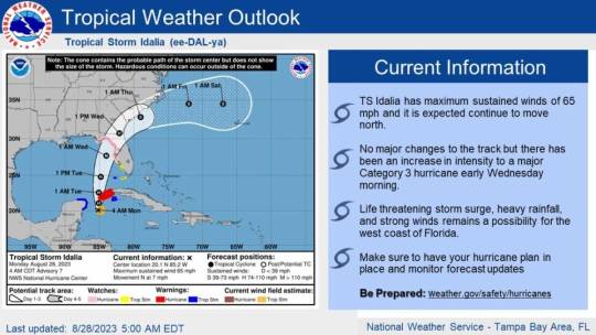
A hurricane warning has been issued for Florida's Nature Coast.
Tropical Storm Idalia is forecast to become a CAT 3 Hurricane with 115 mph sustained winds in the Nature Coast. Expect landfall late Tuesday Night or Wednesday between the Big Bend Area of Florida and Tampa Bay.
- Potential Coastal Storm Surge: The highest of the surge will be around the time of high tide(s) Wednesday.
- Must wait until winds become onshore as the storm passes.
- Levy/Citrus Counties: 7-11 feet AGL (potential for 5 ft higher than 2016 Hermine’s surge)
- Hernando/Pasco Counties: 6 to 9 feet AGL
- Tampa Bay Area: 4 to 7 feet AGL
- Expect heavy rain and areas of saltwater flooding along the coast on Tuesday and Wednesday, especially at times of high tide. The impact will be isolated inland south of Interstate 4. Expect rain of 6-10” with isolated higher amounts along the coast and north of I-4.
- The tornado threat has increased Tuesday from Tampa Bay northward.
- Residents should closely monitor the progress of this system through local media outlets.
- Update and review family emergency plans and preparations.
- Check emergency supply kits.
Hernando County Government Offices and Services Closures
Hernando County Government: Hernando County Government offices, Animal Services, and Library Services will be closed Monday, Tuesday, and Wednesday. Government offices will be closed on Labor Day on Monday, September 4, 2023.
Solid Waste and Recycling Only the mainfill will be open Monday, August 28. The convenience centers will be closed Monday, Tuesday, and Wednesday.
Republic Services Republic Services is operating regular garbage pickup on Monday, August 28. Republic Services will be closed on Tuesday and Wednesday.
Transit Services (TheBus) TheBus is running regular service today and tomorrow, or until winds reach 40 mph (sustained). At that time all Transit Service will end. Tentatively, transit services may be suspended on Wednesday. Thursday, August 31, 2023, we will resume transit services (weather permitting) Click here for Bus Routes
Evacuation Orders
Voluntary Evacuations have been issued for all areas west of US 19, which includes evacuation zones A, B, and C. All residents living in coastal and low-lying areas, as well as manufactured homes county-wide, are included. Residents are advised to seek safe shelter with family or friends who reside in a safe structure.
Shelters to open at Noon on Monday, August 28
Hernando County Emergency Management has opened 4 evacuation shelters that will open today at 12 p.m. West Hernando Middle School D.S. Parrott Middle School Nature Coast High School Hernando High School Please stay informed by monitoring our social media outlets and check for other updates at www.hernandocounty.us/em
Sandbag Locations Now Open in Hernando County
Sand and sandbags are available at Linda Pedersen Park, Anderson Snow Park, Ridge Manor Community Center, and the City of Brooksville Department of Public Works. These self-serve sandbag sites will remain open until 5 pm today and close Tuesday, August 29 at Noon, or if weather conditions begin to deteriorate. Please bring your own shovel.
Tips on how to properly fill and stack your sandbags Fill bags one-half to two-thirds of the way full Over-filled bags will result in a leaky sandbag wall Stack sandbags so that the seams between the bags are staggered Tuck the top of each bag under to ensure that that bag is sealed by its own weight
Stay Connected with Hernando County Emergency Management
Hernando County Government’s Office of Emergency Management continues to monitor and inform our community about storm impacts. Visit the following web and social media sites for more information.
- For the latest local conditions and a complete list of news alerts go to www.HernandoCounty.us/em
- Sign up to receive weather alerts at www.AlertHernando.org
- Follow us on Facebook @HernandoCoGov & @Hernandocountyfire
- Follow us on Twitter @HernandoCoGov
Read the full article
0 notes
Text
Atlantic Tropical Weather Outlook issued by the National Hurricane Center in Miami, FL, USA
2022-09-25 08:00 -0400

Active Systems: The National Hurricane Center is issuing advisories on Tropical Storm Ian, located over the western Caribbean Sea, on Tropical Storm Gaston, located a few hundred miles west of the western Azores, and has issued the last advisory on Post Tropical Cyclone Hermine, located over the far eastern Atlantic.
Central Tropical Atlantic: An area of low pressure located several hundred miles west of the Cabo Verde Islands is producing disorganized shower and thunderstorm activity. Any development of this system should be slow to occur while it moves very little through the early portion of this week. Environmental conditions could become marginally more conducive for development by the middle portion of this week, when the system is forecast to begin moving slowly northward.
* Formation chance through 48 hours...low...10 percent.
* Formation chance through 5 days...low...20 percent.
$$ Forecaster Papin
#bot post#weather#tropical weather#tropical storm#tropical depression#hurricane#atlantic#atlantic ocean#caribbean#gulf of mexico#noaa#national oceanic and atmospheric administration#nhc#national hurricane center
0 notes
Text
The tropical storm forces to suspend acts and classes
The tropical storm forces to suspend acts and classes
The Canary Islands activated last night at 00:00 the maximum alert for the danger of flooding as a result of the foreseeable effects on the Canary Islands of Cyclone Ten, which late yesterday had already become Tropical Storm Hermine, as announced by the Hurricane Center of Miami. Immediately, all events scheduled for the weekend were suspended, as well as classes on Monday, and recommendations…

View On WordPress
0 notes
Photo

Tropical Depression 9 is heading towards Florida and it could become a hurricane named hermine or Ian. I pray that everyone is prepared and stays safe as the storm comes to Florida. https://www.instagram.com/p/Ci3NIkqJm4v/?igshid=NGJjMDIxMWI=
0 notes
Text
The next named storm could be a monster hurricane in the Gulf of Mexico
The next named storm could be a monster hurricane in the Gulf of Mexico
2022-09-22 08:48:11
An area of disorganized activity over the southeastern Caribbean Sea will likely become the next tropical storm — named Hermine — in the next few days, according to the National Hurricane Center.
This small cluster of storms has meteorologists’ attention because both American and European forecasting models have consistently showed them developing into a tropical system and…

View On WordPress
0 notes
Text
Hurricane Warnings Long Island Southern New England Henri Heading Northward Up The East Coast
Hurricane Warnings Long Island Southern New England Henri Heading Northward Up The East Coast
Hurricane Warnings Long Island Southern New England
Henri Heading Northward Up The East Coast
Weather in 5/Joe & Joe Weather Show Latest Podcast
Hurricane Warnings Long Island Southern New England
Henri Heading Northward Up The East Coast
Hurricane warnings have gone up for Southern New England as well as for most of Long Island. Tropical Storm Henri is just about at hurricane strength and is…

View On WordPress
#Hermine Early Storm Surge Forecast#hurricane henri#hurricane warnings#storm surge#tropical storm henri#tropical storm warnings
3 notes
·
View notes
Text
A little while ago I shared a post on my Facebook page from my local news’s weather team about the tropical system that’s in the Caribbean. Basic gist of this post is that they’re positive this system is going to move into the Gulf of Mexico and become Tropical Storm and/or Hurricane Hermine. And I shared this post for the most obvious reason-- most everyone I have friended on Facebook lives in my area and there’s a chance we’ll get hit by it.
Within a few minutes of me sharing the post, someone else commented with a heavily-politically worded remark that had nothing to do with the storm whatsoever.
*sigh* This is why I rarely spend time on Facebook anymore......
2 notes
·
View notes
Photo

New Post has been published on https://techcrunchapp.com/hurricanes-stay-stronger-longer-after-landfall-than-in-past-national-world-news/
Hurricanes stay stronger longer after landfall than in past | National/World News
Hurricanes are keeping their staying power longer once they make landfall, spreading more inland destruction, according to a new study.
Warmer ocean waters from climate change are likely making hurricanes lose power more slowly after landfall, because they act as a reserve fuel tank for moisture, the study found. With Eta threatening Florida and the Gulf Coast in a few days, the study’s lead author warned of more damage away from the coast than in the past.
The new study looked at 71 Atlantic hurricanes with landfalls since 1967. It found that in the 1960s, hurricanes declined two-thirds in wind strength within 17 hours of landfall. But now it generally takes 33 hours for storms to weaken that same degree, according to a study in Wednesday’s journal Nature.
“This is a huge increase,” study author Pinaki Chakraborty, a professor of fluid dynamics at the Okinawa Institute of Science and Technology in Japan. “There’s been a huge slowdown in the decay of hurricanes.”
Hurricane Florence, which in 2018 caused $24 billion in damage, took nearly 50 hours to decay by nearly two-thirds after making landfall near Wrightsville Beach, North Carolina, Chakraborty said. Hurricane Hermine in 2016 took more than three days to lose that much power after hitting Florida’s Apalachee Bay.
As the world warms from human-caused climate change, inland cities like Atlanta should see more damage from future storms that just won’t quit, Chakraborty said.
“If their conclusions are sound, which they seem to be, then at least in the Atlantic, one could argue that insurance rates need to start going up and building codes need to be improved … to compensate for this additional wind and water destructive power reaching farther inland,” said University of Miami hurricane researcher Brian McNoldy, who wasn’t part of the study.
There’s less study of what hurricanes do once they make landfall than out at sea, so Chakraborty said he was surprised when he saw a noticeable trend in decay taking longer. Before he started the study, Chakraborty said he figured the decline in power shouldn’t change over the years even with man-made climate change, because storms tend to lose strength when cut off from warm water that fuels them.
It stops going, like a car that runs out of gas, he said.
But hurricanes aren’t running out of gas as much, especially in the last 25 years when the trend accelerated, Chakraborty said. To find out why, he charted the ocean temperature near where the hurricane had traveled and found it mirrored the decay trend on land.
Researchers then simulated hurricanes that were identical except for water temperature. Seeing the warmer water storms decayed slower, they reached their conclusion: The trend showing a slowdown of hurricane decay resulted from warmer ocean water temperatures, caused by the burning of coal, oil and natural gas.
“That’s an amazing signal that they found,” said National Oceanic and Atmospheric Administration climate and hurricane scientist Jim Kossin, who wasn’t part of the study but did review it for the journal Nature.
This study joins previous studies, many by Kossin, that show tropical systems are slowing down more, wetter, moving more toward the poles — and that the strongest hurricanes are getting stronger.
Follow Seth Borenstein on Twitter: @borenbears .
The Associated Press Health & Science Department receives support from the Howard Hughes Medical Institute’s Department of Science Education. The AP is solely responsible for all content.
(function(d, s, id) var js, fjs = d.getElementsByTagName(s)[0]; if (d.getElementById(id)) return; js = d.createElement(s); js.id = id; js.src = "https://connect.facebook.net/en_US/sdk.js#xfbml=1&version=v2.5&appId=730238567043245"; fjs.parentNode.insertBefore(js, fjs); (document, 'script', 'facebook-jssdk'));
0 notes
Text
TL;DR, please don’t expect much from me through early next week. If anyone needs me hmu on IM or Discord. Excessive anxiety fueled rambling below cut.
Yeah, so uh, hi, my name is Trip, and I unfortunately live in the magical city of Orlando in Florida. You may have heard about this big fucking hurricane by the name of Irma. That may or may not hit my state. Right now it’s too damn early to tell.
Why am I telling y’all this? Because I’m 100% WAY too anxious to focus on literally anything rp related as a result. I’ve been wanting to poke some things when I get home after work but honestly work is stressing me out to no end because of the fucking hurricane.
Before you ask, yes I promise, we’re prepared. We picked up canned food and plenty of water and the cats have what they need and we’re trying to keep the truck’s tank full. Between me being a native Floridian and this not being my first rodeo and the fact I’ve been attempting to combat the anxiety by over preparing, I’m 99% sure we’ll be a-ok regardless of what may happen.
What’s been fucking me up is how everyone else is freaking the fuck out. I work at a call center and every other call is about the hurricane, and some people... Really do not help things tbh. Between what I handle call wise and what I can’t help but overhear my neighbors handling, all the hurricane this hurricane that is really making it hard to keep my anxiety down to manageable levels.
Basically, all I’m trying rn is to keep an eye on what the storm does and remember breathing properly is good. If we do end up deciding to evacuate (because honestly I do not trust our apartment building for jack shit when it comes to the winds, between not being able to board up, the massive trees right next to it and the management being very uninterested in anything) we’re going to my parent’s place which is still in central Florida, on a hill, and in a very sturdy and secure house. Seriously. They’ve lived there since before I was born and the only damage I’m aware of that it’s ever sustained from a hurricane or tropical storm was from Hermine last year when our neighbor’s bigass maple tree fell on our roof and poked a little hole in it.
So yeah, I’m just gonna come home this week and spend my time trying to breath and play DAI for something to keep me occupied, and I promise I’ll keep everyone updated if we do evacuate and shit so please don’t worry, I’m doing enough of that for everyone.
#ooc#I'm just#gonna go be on thedasfinest#and be playing some of Alaric's run#since he's not even quizzy#I'm just doing it for the screenshots and to romance Cass tbh
9 notes
·
View notes
Link
After making landfall as a tropical storm on Sunday, Amanda turned deadly, and will continue to threaten the region with widespread flooding and dangerous mudslides as it nears the Atlantic Basin into midweek.Before making landfall Sunday morning, the system strengthened into a tropical storm and was given the name Amanda, making it the first-named storm of the 2020 East Pacific hurricane season. A new round of torrential rainfall arrived in El Salvador and southern Guatemala on Sunday as Amanda moved inland. Officials in El Salvador issued an "Red Alert" and extended the state of emergency due to this surge of heavier rain.As of late Sunday morning, there are reports of at least 11 deaths in El Salvador due to impacts from the then Tropical Storm Amanda.> Nuestro despliegue a nivel nacional redobla sus esfuerzos ante la AlertaRoja por la TormentaAmandaSV. > > Haz tu parte, sigue las indicaciones de @PROCIVILSV, QuédateEnCasa. pic.twitter.com/331gKMKwAf> > -- Ministerio de la Defensa Nacional (@DefensaSV) May 31, 2020By Sunday afternoon, Amanda was downgraded to a tropical depression.Amanda is forecast to continue tracking to the northwest across Guatemala into the beginning of the week. The rugged terrain will help to rip the storm apart, but the remaining tropical moisture will continue to fuel heavy rain and thunderstorms across Central America through the beginning of the week.Reports of flooding are already emerging from Costa Rica to end the weekend. "Heavy rainfall will be the greatest threat over Central America, particularly in the higher terrain or Guatemala and El Salvador where rainfall totals of 18-24 inches are possible," AccuWeather Senior Meteorologist Randy Adkins said.The highest terrain could pick up an AccuWeather Local StormMax™ of 800 mm (30 inches).CLICK HERE FOR THE FREE ACCUWEATHER APP"Heavy rainfall from Amanda will likely trigger not only flooding threats, but serious mudslides as well for portions of Guatemala and El Salvador early this week'" stated AccuWeather Meteorologist Mary Gilbert. "These mudslides can be very destructive and even life-threatening in nature as heavy rain continues to pound the area." While Amanda will continue to lose wind strength, any locally strong wind gusts can knock over trees or power lines due to the saturated ground.Adkins added, "Amanda is forecast to be a 1 on the AccuWeather RealImpact™ Scale for Hurricanes due to the risks posed by very heavy rainfall."Amanda is forecast to move into the Bay of Campeche before the middle of the week and depending on the strength of the storm, it could set records."If Amanda were to survive and make it into the Bay of Campeche as a named system, it would be unprecedented," stated AccuWeather Meteorologist Courtney Travis. "The only tropical system to cross from the Pacific Ocean to the Atlantic Ocean Basin since 1950 was Hermine in 2010.""However, Hermine was named in the Gulf of Mexico, having only reached tropical depression status in the East Pacific," she added. This satellite image shows Amanda tracking across Central America as a tropical storm on Sunday afternoon, local time. (Photo/RAMMB) Although tropical systems are usually shredded by the rough terrain of Central America when traveling from the East Pacific Basin to the Atlantic Basin. Several storms have made this trek and dissipated then redeveloped once in the Atlantic Basin, according to Travis.AccuWeather forecasters will be monitoring Amanda into the middle of the week and will continue to watch for potential tropical development through the early part of June as the developing weather pattern may keep the region active.The same gyre that generated Amanda could be powerful enough produce additional tropical activity in the coming weeks."A tropical gyre is just a large slowly spinning area of disturbed weather, that can be as wide as a 1,500 km (1,000 miles) in diameter. When they form over Central America, they can create extra moisture to spawn tropical development on the Atlantic side or the Pacific side or sometimes both," said AccuWeather Senior Meteorologist Alex Sosnowski.Because of this, AccuWeather meteorologists will also be monitoring the waters of the southern Gulf of Mexico and the western Caribbean very closely for tropical development through the middle of June.Keep checking back on AccuWeather.com and stay tuned to the AccuWeather Network on DirecTV, Frontier and Verizon Fios.
from Yahoo News - Latest News & Headlines https://ift.tt/2TVCWFg
0 notes
Text
Nature Hurricane Michael Live Updates: Category 2 Storm Bears Down on Florida Panhandle
Nature Hurricane Michael Live Updates: Category 2 Storm Bears Down on Florida Panhandle Nature Hurricane Michael Live Updates: Category 2 Storm Bears Down on Florida Panhandle http://www.nature-business.com/nature-hurricane-michael-live-updates-category-2-storm-bears-down-on-florida-panhandle/
Nature
Image
Hurricane Michael was upgraded to a Category 2 storm as it barreled toward the Gulf Coast. It could hit Florida as a Category 3 hurricane.CreditCreditNational Oceanic and Atmospheric Administration, via Agence France-Presse — Getty Images
Hurricane Michael strengthened into a Category 2 storm on Tuesday as it took clearer aim at the Florida Panhandle, which was bracing for a major hurricane to make landfall on Wednesday.
The hurricane, poised to become the strongest tropical system to make landfall in the mainland United States so far this year, has sustained winds of 110 miles per hour, the National Hurricane Center said Tuesday morning. The storm’s winds are expected to increase, and Michael is on track to become a Category 3 storm later in the day.
Governors in at least three states have declared emergencies, and the local authorities are urging people to evacuate or to fortify their homes ahead of the storm.
Here are the latest developments:
• As of 11 a.m. Tuesday, the National Hurricane Center said the storm was moving north-northwest at 12 m.p.h. in the southeastern Gulf of Mexico. Click on the map below to see the storm’s projected path.
• A hurricane warning was in effect from the Alabama-Florida border to the Suwannee River in Florida. A hurricane watch was in effect from the Alabama-Florida border to the Mississippi-Alabama border.
• Hurricane Michael could make landfall as a Category 3 storm on Wednesday anywhere from Destin, Fla., to Apalachee Bay, the National Hurricane Center said. It was projected then to veer northeast — through Georgia and the Carolinas — before heading into the Atlantic on Thursday night.
• President Trump on Monday said the Federal Emergency Management Agency was in full preparation mode. “It looked a couple of days ago like it was not going to be much,” he said of the storm, “and now it’s looking like it could be a very big one, so we’re prepared, and good luck.”
• Gas, generators and other emergency supplies were reported sold out in many places, The Tallahassee Democrat reported.
Florida’s governor warns of a ‘monstrous storm’
Gov. Rick Scott of Florida pleaded with residents on Tuesday to heed evacuation orders and to prepare for a storm that he warned “could bring total devastation to parts of our state.”
“Hurricane Michael is a monstrous storm, and the forecast keeps getting more dangerous,” Mr. Scott said during an appearance at the state’s emergency operations center in Tallahassee, the Florida capital.
By Tuesday morning, a handful of counties had issued evacuation orders that were often targeted at visitors or people who live in mobile homes or low-lying areas. “If we need to have evacuations, local communities need to issue the orders now,” Mr. Scott said. “We cannot afford to wait.”
Mr. Scott, a Republican who is on the ballot next month for a United States Senate seat, has declared a state of emergency in 35 counties and deployed 2,000 members of the National Guard. He said he believed people were taking the storm “seriously,” but he also seemed to suggest that some local officials, familiar with the furies of triple-digit wind speeds and torrential rains, were perhaps not sufficiently fearful of Hurricane Michael’s perils.
“I think a lot of people have been through 110-mile-an-hour winds, they’ve been through 12 inches of rain,” he said. “I think what’s different about this storm that really concerns me is the storm surge.”
Weather forecasters, who have said storm surge could reach 12 feet in some areas, have issued a storm surge warning for the stretch between the border of Okaloosa and Walton Counties to the Anclote River. A storm surge watch is in effect on both sides of the warning area: from the Okaloosa and Walton county line westward to Florida’s border with Alabama, and from the Anclote to Anna Maria Island.
On Tuesday, Mr. Scott offered an admonition to residents considering whether to flee, and he said that time was running short.
“If you’re on the fence, don’t think about it,” he said. “Do it.”
Storm could hit ‘an incredibly vulnerable spot’
In many ways, climate change has made hurricanes worse: A rise in sea level is causing higher storm surges, and warmer air is leading to rainier storms.
With Hurricane Michael, local geography also has a role to play in the storm’s impact.
If the predictions of its path hold, the hurricane will be the first to hit this area since Hurricane Hermine in 2016, said Jamie Rhome, a storm surge specialist at the National Hurricane Center. That storm was a Category 1. Hurricane Michael is expected to strike land as a Category 3, a major storm with wind speeds of 111 to 129 m.p.h. That’s enough to uproot trees and tear off roof decking.
Wind, while a source of destruction in storms, is not the only threat. Surge can devastate coastal communities, and the rain dumped by storms can cause flooding far inland. Mr. Rhome noted that while this hurricane’s path was still not certain, its probable impact at the bend of Florida on the way into the Panhandle could be very destructive. “It’s an incredibly vulnerable spot,” he said. “Regardless of whether the track moves a little to the left or the right, or wobbles,” he said, “it’s going to be a bad storm surge event for somebody.”
[Here’s our guide to how hurricanes are classified and why a change in category doesn’t tell the whole story.]
Rick Luettich, director of the Institute of Marine Sciences at the University of North Carolina, said that the area was especially susceptible to a large storm surge because of its “funnel-shaped geometry and broad, shallow continental shelf.”
If there is good news, he said it’s that the area of possible impact “is not as densely populated as other parts of the Gulf Coast, and therefore the human consequences of such a large surge should be less severe than if it hit further west on the Florida Panhandle or further east,” in say, Tampa.
[Does it seem as if severe storms keep damaging the same areas, and those areas are simply built up again? Part of that is the way disaster funding works. Read about it here.]
States throughout the South and Mid-Atlantic are also getting ready
Gov. Nathan Deal of Georgia on Tuesday declared an emergency for 92 of his state’s 159 counties, following Gov. Kay Ivey of Alabama, who issued an emergency declaration on Monday.
The storm is expected to cross Georgia on Wednesday and Thursday, and then move offshore into the Atlantic on Friday morning. By the time it does, it will have swept over parts of the Carolinas that were deluged when Hurricane Florence, a Category 1 storm, struck last month.
“Because of the damage caused by Hurricane Florence and the fact that there’s still some standing water in places, we have to be that much more alert about the damage that Hurricane Michael could do,” Gov. Roy Cooper said at a news conference on Tuesday morning in Raleigh, North Carolina’s capital.
“We know we have to be ready, and hurricane-weary North Carolinians cannot let their guard down just because we’re fatigued with Hurricane Florence.”
Mr. Trump also warned residents in areas to the north to be on alert.
Florida is extending the voter registration deadline in some places
Election offices that are closed on Tuesday because of the hurricane will be able to accept paper voter registration applications on the day they reopen, whenever that might be, Secretary of State Ken Detzner said in a memo on Monday night.
The close of voter registration had been scheduled for Tuesday, four weeks before Election Day in a state with some of the country’s marquee races, including contests for governor and a United States Senate seat.
But Mr. Detzner, a Republican who faced Democratic pressure to extend the deadline, effectively waived the deadline, writing that his decision would “ensure that each Supervisor of Elections Office has the same amount of days to register voters at their offices.”
The extension will not apply in all 35 counties for which Governor Scott declared a state of emergency. Election offices in some of those counties, like Alachua, which includes Gainesville, and Hillsborough, which includes Tampa, were expected to be open for business on Tuesday morning.
The deadline for online voter registration — 11:59 p.m. on Tuesday — was unchanged.
Alan Blinder and John Schwartz contributed reporting.
Read More | https://www.nytimes.com/2018/10/09/us/hurricane-michael.html |
Nature Hurricane Michael Live Updates: Category 2 Storm Bears Down on Florida Panhandle, in 2018-10-09 16:42:21
0 notes
Text
Atlantic Tropical Weather Outlook issued by the National Hurricane Center in Miami, FL, USA
2022-09-25 02:00 -0400

Active Systems: The National Hurricane Center is issuing advisories on Tropical Storm Ian, located over the western Caribbean Sea, on Tropical Storm Gaston, located near the western Azores, and on Tropical Depression Hermine, located over the far eastern Atlantic.
Central Tropical Atlantic: An area of low pressure located several hundred miles west of the Cabo Verde Islands is producing minimal shower activity. Any development of this system should be slow to occur while it moves very little through the early portion of next week. Environmental conditions could become marginally more conducive for development by the middle portion of next week, when the system is forecast to begin moving slowly northward.
* Formation chance through 48 hours...low...10 percent.
* Formation chance through 5 days...low...20 percent.
$$ Forecaster Beven
#bot post#weather#tropical weather#tropical storm#tropical depression#hurricane#atlantic#atlantic ocean#caribbean#gulf of mexico#noaa#national oceanic and atmospheric administration#nhc#national hurricane center
0 notes
Text
Nature Hurricane Michael Live Updates: Category 2 Storm Bears Down on Florida Panhandle
Nature Hurricane Michael Live Updates: Category 2 Storm Bears Down on Florida Panhandle Nature Hurricane Michael Live Updates: Category 2 Storm Bears Down on Florida Panhandle http://www.nature-business.com/nature-hurricane-michael-live-updates-category-2-storm-bears-down-on-florida-panhandle/
Nature
Image
Hurricane Michael was upgraded to a Category 2 storm as it barreled toward the Gulf Coast. It could hit Florida as a Category 3 hurricane.CreditCreditNational Oceanic and Atmospheric Administration, via Agence France-Presse — Getty Images
Hurricane Michael strengthened into a Category 2 storm on Tuesday as it took clearer aim at the Florida Panhandle, which was bracing for a major hurricane to make landfall on Wednesday.
The hurricane, poised to become the strongest tropical system to make landfall in the mainland United States so far this year, has sustained winds of 110 miles per hour, the National Hurricane Center said Tuesday morning. The storm’s winds are expected to increase, and Michael is on track to become a Category 3 storm later in the day.
Governors in at least three states have declared emergencies, and the local authorities are urging people to evacuate or to fortify their homes ahead of the storm.
Here are the latest developments:
• As of 11 a.m. Tuesday, the National Hurricane Center said the storm was moving north-northwest at 12 m.p.h. in the southeastern Gulf of Mexico. Click on the map below to see the storm’s projected path.
• A hurricane warning was in effect from the Alabama-Florida border to the Suwannee River in Florida. A hurricane watch was in effect from the Alabama-Florida border to the Mississippi-Alabama border.
• Hurricane Michael could make landfall as a Category 3 storm on Wednesday anywhere from Destin, Fla., to Apalachee Bay, the National Hurricane Center said. It was projected then to veer northeast — through Georgia and the Carolinas — before heading into the Atlantic on Thursday night.
• President Trump on Monday said the Federal Emergency Management Agency was in full preparation mode. “It looked a couple of days ago like it was not going to be much,” he said of the storm, “and now it’s looking like it could be a very big one, so we’re prepared, and good luck.”
• Gas, generators and other emergency supplies were reported sold out in many places, The Tallahassee Democrat reported.
Florida’s governor warns of a ‘monstrous storm’
Gov. Rick Scott of Florida pleaded with residents on Tuesday to heed evacuation orders and to prepare for a storm that he warned “could bring total devastation to parts of our state.”
“Hurricane Michael is a monstrous storm, and the forecast keeps getting more dangerous,” Mr. Scott said during an appearance at the state’s emergency operations center in Tallahassee, the Florida capital.
By Tuesday morning, a handful of counties had issued evacuation orders that were often targeted at visitors or people who live in mobile homes or low-lying areas. “If we need to have evacuations, local communities need to issue the orders now,” Mr. Scott said. “We cannot afford to wait.”
Mr. Scott, a Republican who is on the ballot next month for a United States Senate seat, has declared a state of emergency in 35 counties and deployed 2,000 members of the National Guard. He said he believed people were taking the storm “seriously,” but he also seemed to suggest that some local officials, familiar with the furies of triple-digit wind speeds and torrential rains, were perhaps not sufficiently fearful of Hurricane Michael’s perils.
“I think a lot of people have been through 110-mile-an-hour winds, they’ve been through 12 inches of rain,” he said. “I think what’s different about this storm that really concerns me is the storm surge.”
Weather forecasters, who have said storm surge could reach 12 feet in some areas, have issued a storm surge warning for the stretch between the border of Okaloosa and Walton Counties to the Anclote River. A storm surge watch is in effect on both sides of the warning area: from the Okaloosa and Walton county line westward to Florida’s border with Alabama, and from the Anclote to Anna Maria Island.
On Tuesday, Mr. Scott offered an admonition to residents considering whether to flee, and he said that time was running short.
“If you’re on the fence, don’t think about it,” he said. “Do it.”
Storm could hit ‘an incredibly vulnerable spot’
In many ways, climate change has made hurricanes worse: A rise in sea level is causing higher storm surges, and warmer air is leading to rainier storms.
With Hurricane Michael, local geography also has a role to play in the storm’s impact.
If the predictions of its path hold, the hurricane will be the first to hit this area since Hurricane Hermine in 2016, said Jamie Rhome, a storm surge specialist at the National Hurricane Center. That storm was a Category 1. Hurricane Michael is expected to strike land as a Category 3, a major storm with wind speeds of 111 to 129 m.p.h. That’s enough to uproot trees and tear off roof decking.
Wind, while a source of destruction in storms, is not the only threat. Surge can devastate coastal communities, and the rain dumped by storms can cause flooding far inland. Mr. Rhome noted that while this hurricane’s path was still not certain, its probable impact at the bend of Florida on the way into the Panhandle could be very destructive. “It’s an incredibly vulnerable spot,” he said. “Regardless of whether the track moves a little to the left or the right, or wobbles,” he said, “it’s going to be a bad storm surge event for somebody.”
[Here’s our guide to how hurricanes are classified and why a change in category doesn’t tell the whole story.]
Rick Luettich, director of the Institute of Marine Sciences at the University of North Carolina, said that the area was especially susceptible to a large storm surge because of its “funnel-shaped geometry and broad, shallow continental shelf.”
If there is good news, he said it’s that the area of possible impact “is not as densely populated as other parts of the Gulf Coast, and therefore the human consequences of such a large surge should be less severe than if it hit further west on the Florida Panhandle or further east,” in say, Tampa.
[Does it seem as if severe storms keep damaging the same areas, and those areas are simply built up again? Part of that is the way disaster funding works. Read about it here.]
States throughout the South and Mid-Atlantic are also getting ready
Gov. Nathan Deal of Georgia on Tuesday declared an emergency for 92 of his state’s 159 counties, following Gov. Kay Ivey of Alabama, who issued an emergency declaration on Monday.
The storm is expected to cross Georgia on Wednesday and Thursday, and then move offshore into the Atlantic on Friday morning. By the time it does, it will have swept over parts of the Carolinas that were deluged when Hurricane Florence, a Category 1 storm, struck last month.
“Because of the damage caused by Hurricane Florence and the fact that there’s still some standing water in places, we have to be that much more alert about the damage that Hurricane Michael could do,” Gov. Roy Cooper said at a news conference on Tuesday morning in Raleigh, North Carolina’s capital.
“We know we have to be ready, and hurricane-weary North Carolinians cannot let their guard down just because we’re fatigued with Hurricane Florence.”
Mr. Trump also warned residents in areas to the north to be on alert.
Florida is extending the voter registration deadline in some places
Election offices that are closed on Tuesday because of the hurricane will be able to accept paper voter registration applications on the day they reopen, whenever that might be, Secretary of State Ken Detzner said in a memo on Monday night.
The close of voter registration had been scheduled for Tuesday, four weeks before Election Day in a state with some of the country’s marquee races, including contests for governor and a United States Senate seat.
But Mr. Detzner, a Republican who faced Democratic pressure to extend the deadline, effectively waived the deadline, writing that his decision would “ensure that each Supervisor of Elections Office has the same amount of days to register voters at their offices.”
The extension will not apply in all 35 counties for which Governor Scott declared a state of emergency. Election offices in some of those counties, like Alachua, which includes Gainesville, and Hillsborough, which includes Tampa, were expected to be open for business on Tuesday morning.
The deadline for online voter registration — 11:59 p.m. on Tuesday — was unchanged.
Alan Blinder and John Schwartz contributed reporting.
Read More | https://www.nytimes.com/2018/10/09/us/hurricane-michael.html |
Nature Hurricane Michael Live Updates: Category 2 Storm Bears Down on Florida Panhandle, in 2018-10-09 16:42:21
0 notes
Text
Nature Hurricane Michael Live Updates: Category 2 Storm Bears Down on Florida Panhandle
Nature Hurricane Michael Live Updates: Category 2 Storm Bears Down on Florida Panhandle Nature Hurricane Michael Live Updates: Category 2 Storm Bears Down on Florida Panhandle https://ift.tt/2NzrFEZ
Nature
Image
Hurricane Michael was upgraded to a Category 2 storm as it barreled toward the Gulf Coast. It could hit Florida as a Category 3 hurricane.CreditCreditNational Oceanic and Atmospheric Administration, via Agence France-Presse — Getty Images
Hurricane Michael strengthened into a Category 2 storm on Tuesday as it took clearer aim at the Florida Panhandle, which was bracing for a major hurricane to make landfall on Wednesday.
The hurricane, poised to become the strongest tropical system to make landfall in the mainland United States so far this year, has sustained winds of 110 miles per hour, the National Hurricane Center said Tuesday morning. The storm’s winds are expected to increase, and Michael is on track to become a Category 3 storm later in the day.
Governors in at least three states have declared emergencies, and the local authorities are urging people to evacuate or to fortify their homes ahead of the storm.
Here are the latest developments:
• As of 11 a.m. Tuesday, the National Hurricane Center said the storm was moving north-northwest at 12 m.p.h. in the southeastern Gulf of Mexico. Click on the map below to see the storm’s projected path.
• A hurricane warning was in effect from the Alabama-Florida border to the Suwannee River in Florida. A hurricane watch was in effect from the Alabama-Florida border to the Mississippi-Alabama border.
• Hurricane Michael could make landfall as a Category 3 storm on Wednesday anywhere from Destin, Fla., to Apalachee Bay, the National Hurricane Center said. It was projected then to veer northeast — through Georgia and the Carolinas — before heading into the Atlantic on Thursday night.
• President Trump on Monday said the Federal Emergency Management Agency was in full preparation mode. “It looked a couple of days ago like it was not going to be much,” he said of the storm, “and now it’s looking like it could be a very big one, so we’re prepared, and good luck.”
• Gas, generators and other emergency supplies were reported sold out in many places, The Tallahassee Democrat reported.
Florida’s governor warns of a ‘monstrous storm’
Gov. Rick Scott of Florida pleaded with residents on Tuesday to heed evacuation orders and to prepare for a storm that he warned “could bring total devastation to parts of our state.”
“Hurricane Michael is a monstrous storm, and the forecast keeps getting more dangerous,” Mr. Scott said during an appearance at the state’s emergency operations center in Tallahassee, the Florida capital.
By Tuesday morning, a handful of counties had issued evacuation orders that were often targeted at visitors or people who live in mobile homes or low-lying areas. “If we need to have evacuations, local communities need to issue the orders now,” Mr. Scott said. “We cannot afford to wait.”
Mr. Scott, a Republican who is on the ballot next month for a United States Senate seat, has declared a state of emergency in 35 counties and deployed 2,000 members of the National Guard. He said he believed people were taking the storm “seriously,” but he also seemed to suggest that some local officials, familiar with the furies of triple-digit wind speeds and torrential rains, were perhaps not sufficiently fearful of Hurricane Michael’s perils.
“I think a lot of people have been through 110-mile-an-hour winds, they’ve been through 12 inches of rain,” he said. “I think what’s different about this storm that really concerns me is the storm surge.”
Weather forecasters, who have said storm surge could reach 12 feet in some areas, have issued a storm surge warning for the stretch between the border of Okaloosa and Walton Counties to the Anclote River. A storm surge watch is in effect on both sides of the warning area: from the Okaloosa and Walton county line westward to Florida’s border with Alabama, and from the Anclote to Anna Maria Island.
On Tuesday, Mr. Scott offered an admonition to residents considering whether to flee, and he said that time was running short.
“If you’re on the fence, don’t think about it,” he said. “Do it.”
Storm could hit ‘an incredibly vulnerable spot’
In many ways, climate change has made hurricanes worse: A rise in sea level is causing higher storm surges, and warmer air is leading to rainier storms.
With Hurricane Michael, local geography also has a role to play in the storm’s impact.
If the predictions of its path hold, the hurricane will be the first to hit this area since Hurricane Hermine in 2016, said Jamie Rhome, a storm surge specialist at the National Hurricane Center. That storm was a Category 1. Hurricane Michael is expected to strike land as a Category 3, a major storm with wind speeds of 111 to 129 m.p.h. That’s enough to uproot trees and tear off roof decking.
Wind, while a source of destruction in storms, is not the only threat. Surge can devastate coastal communities, and the rain dumped by storms can cause flooding far inland. Mr. Rhome noted that while this hurricane’s path was still not certain, its probable impact at the bend of Florida on the way into the Panhandle could be very destructive. “It’s an incredibly vulnerable spot,” he said. “Regardless of whether the track moves a little to the left or the right, or wobbles,” he said, “it’s going to be a bad storm surge event for somebody.”
[Here’s our guide to how hurricanes are classified and why a change in category doesn’t tell the whole story.]
Rick Luettich, director of the Institute of Marine Sciences at the University of North Carolina, said that the area was especially susceptible to a large storm surge because of its “funnel-shaped geometry and broad, shallow continental shelf.”
If there is good news, he said it’s that the area of possible impact “is not as densely populated as other parts of the Gulf Coast, and therefore the human consequences of such a large surge should be less severe than if it hit further west on the Florida Panhandle or further east,” in say, Tampa.
[Does it seem as if severe storms keep damaging the same areas, and those areas are simply built up again? Part of that is the way disaster funding works. Read about it here.]
States throughout the South and Mid-Atlantic are also getting ready
Gov. Nathan Deal of Georgia on Tuesday declared an emergency for 92 of his state’s 159 counties, following Gov. Kay Ivey of Alabama, who issued an emergency declaration on Monday.
The storm is expected to cross Georgia on Wednesday and Thursday, and then move offshore into the Atlantic on Friday morning. By the time it does, it will have swept over parts of the Carolinas that were deluged when Hurricane Florence, a Category 1 storm, struck last month.
“Because of the damage caused by Hurricane Florence and the fact that there’s still some standing water in places, we have to be that much more alert about the damage that Hurricane Michael could do,” Gov. Roy Cooper said at a news conference on Tuesday morning in Raleigh, North Carolina’s capital.
“We know we have to be ready, and hurricane-weary North Carolinians cannot let their guard down just because we’re fatigued with Hurricane Florence.”
Mr. Trump also warned residents in areas to the north to be on alert.
Florida is extending the voter registration deadline in some places
Election offices that are closed on Tuesday because of the hurricane will be able to accept paper voter registration applications on the day they reopen, whenever that might be, Secretary of State Ken Detzner said in a memo on Monday night.
The close of voter registration had been scheduled for Tuesday, four weeks before Election Day in a state with some of the country’s marquee races, including contests for governor and a United States Senate seat.
But Mr. Detzner, a Republican who faced Democratic pressure to extend the deadline, effectively waived the deadline, writing that his decision would “ensure that each Supervisor of Elections Office has the same amount of days to register voters at their offices.”
The extension will not apply in all 35 counties for which Governor Scott declared a state of emergency. Election offices in some of those counties, like Alachua, which includes Gainesville, and Hillsborough, which includes Tampa, were expected to be open for business on Tuesday morning.
The deadline for online voter registration — 11:59 p.m. on Tuesday — was unchanged.
Alan Blinder and John Schwartz contributed reporting.
Read More | https://ift.tt/2Pkwzaw |
Nature Hurricane Michael Live Updates: Category 2 Storm Bears Down on Florida Panhandle, in 2018-10-09 16:42:21
0 notes
Last Seen Blogs

mochichan46
Top Naughty Webcam Chat

sedados
Musicalis universalis

randombutcher
Random Butcher

alperfigen34
İsimsiz

iwasabirdcage
& You Were Meant To Fly