#national hurricane center
Text

Looking into the powerful eye of a hurricane! Beautiful but terrifying
#astronomy#nasa#astronomers#universe#astrophotography#nasa photos#nasawebb#astrophysics#outer space#hubble space telescope#national hurricane center#weather#space exploration#space station#space shuttle#spacecraft#space#james webb space telescope#space photography#space science#planetary science#science#beautiful earth#planet earth#planetary nebula#earth#astronauts#astro community#astro notes#astro observations
510 notes
·
View notes
Text
Atlantic Tropical Weather Outlook issued by the National Hurricane Center in Miami, FL, USA
2024-04-24, 20:00 EDT

For the North Atlantic...Caribbean Sea and the Gulf of Mexico:
East-Central Subtropical Atlantic: An area of low pressure located about 900 miles northwest of the Cabo Verde Islands has been producing a small but persistent area of showers and thunderstorms to the east of its center since this morning. However, the low is forecast to move southwestward at 10 to 15 mph into an area of stronger upper-level winds tonight and tomorrow, and additional development is not expected.
No additional Special Tropical Weather Outlooks are scheduled for this system unless conditions warrant. Regularly scheduled Tropical Weather Outlooks will resume on May 15, 2024, and Special Tropical Weather Outlooks will be issued as necessary during the remainder of the off-season.
* Formation chance through 48 hours...low...10 percent.
* Formation chance through 7 days...low...10 percent.
$$ Forecaster Berg/Brown
#sorry the beginning of the text was cut off at first! fixed now#the NHC changes the advisory formatting every year ever so slightly so i have to adjust how the bot parses them the first few posts lol#not gonna bother fixing the text timestamp since they sorta just post the special advisories whenever#bot tags:#bot post#meteorology#weather#tropical weather#tropical storm#tropical depression#hurricane#atlantic#atlantic ocean#caribbean#gulf of mexico#noaa#national oceanic and atmospheric administration#nhc#national hurricane center
15 notes
·
View notes
Text
#HurricaneLee now a Category 5 storm. Winds: 160 MPH, gusts approaching 195-200 MPH.
https://www.nhc.noaa.gov/text/refresh/MIATCPAT3+shtml/080251.shtml?
2 notes
·
View notes
Text
TOPLINE
Former President Donald Trump repeatedly asked national security officials about whether China had produced technology to spawn hurricanes and fire them at the United States during his first year in office, according to Rolling Stone, adding to a growing list of recent reports alleging Trump regularly broached outlandish ideas to top officials.
KEY FACTS
• Trump would also ask advisors whether use of such a weapon would be considered an act of war, and if the U.S. should respond with military strikes, according to Rolling Stone, citing two unnamed Trump Administration senior officials and another unnamed source with knowledge of the matter.
• China has attempted to manipulate weather in the past, and claimed to successfully keep rain from falling during the 2008 Summer Olympics, but there's no evidence China or any other country has the technology to somehow create and guide enormous storms on the other side of the planet.
• Trump's questioning about a Chinese "hurricane gun," as officials called it, continued until 2018 before he seemed to dismiss the idea and eventually started joking about it, according to Rolling Stone.
• Two major hurricanes struck the U.S. mainland during Trump's first year as president, Hurricane Harvey in Texas and Hurricane Irma in Florida, while Hurricane Maria devastated Puerto Rico.
• A Trump spokeswoman did not immediately respond to a request for comment from Forbes.
CRUCIAL QUOTE
“It was almost too stupid for words,” a former White House official told Rolling Stone. “I did not get the sense he was joking at all.”
KEY BACKGROUND
Trump's term coincided with a historic uptick in hurricane activity across the Atlantic basin, which led to some of the ex-president's most bizarre comments and controversies during his time in office. In 2019, it was reported Trump told national security officials they should look into dropping nuclear bombs on developing tropical systems—an idea that's long been rejected by meteorologists as ineffective and incredibly dangerous. Trump in 2019 also presented to reporters an altered National Hurricane Center forecast track including Alabama in the projected path of Hurricane Dorian. Trump, according to reports, personally doctored the map using a Sharpie marker, in an incident that became popularly known as Sharpiegate. The fake storm track was apparently an effort from Trump to fire back at criticism over a September 1, 2019, tweet where he said "South Carolina, North Carolina, Georgia, and Alabama will most likely be hit (much) harder than anticipated," even though Alabama was not included in the official National Hurricane Center forecast.
TANGENT
The New York Times reported last week Trump approached former Defense Secretary Mark Esper in 2020 to suggest shooting missiles into Mexico to "destroy the drug labs." He also reportedly suggested deploying thousands of troops to respond to Black Lives Matter protests after George Floyd’s death.
#us politics#news#donald trump#trump administration#2022#forbes#china#hurricanes#rolling stone#rolling stone magazine#Mark Esper#sharpiegate#the new york times#National Hurricane Center#weather#weather control
39 notes
·
View notes
Text
It is said that moving a butterfly's wings can cause a hurricane on the other side of the globe, I guess I'm on the other side because there is only a hurricane in my life

7 notes
·
View notes
Text

Read the remaining facts, plus myths, quotes, faqs and an epic quiz at: 50 Hurricane Facts to Fuel Your Curiosity About Nature’s Force
#carolina hurricanes#hurricane maria#hilda hurricane#national hurricane center#hurricaneseason#tornado#earthquake#fun facts#facts#random facts
1 note
·
View note
Link
It’s already early May and that means it’s getting close to the start of the North Atlantic Basin tropical cyclone season.
If you live on or relatively close to the coast of the North Atlantic, Gulf of Mexico, or the Caribbean Sea, this is a good time to become reacquainted with how to deal with tropical cyclones. The link above provides an excellent set of reminders.
Every day during the hurricane season I visit the official NOAA site. Getting accurate information is essential in an era of disinformation.
National Hurricane Center
If you’re looking for a general forecast for the 2023 season, the go-to place is the Colorado State University Hurricane Seasonal Forecasting site. It’s ironic that a landlocked Mountain state has a university known for it’s tropical weather expertise, but the CSU team is top notch.
Here is their extended-range forecast issued on April 13th.
If you want the TL;DR forecast that isn’t over 40 pages long, here is what they predict for 2023.

So it looks like a slightly below average season in terms of activity.
But even a low activity season can bring destruction. The 1992 Atlantic season had just six named storms – but the first of those was Category 5 Hurricane Andrew which made landfall both in Florida and in Louisiana.
#tropical cyclones#2023 atlantic basin hurricane season#hurricanes#tropical storms#2023 extended range forecast#national hurricane center#noaa#el niño#hurricane preparedness week#hurricane andrew#colorado state university
0 notes
Text
Atlantic Tropical Weather Outlook issued by the National Hurricane Center in Miami, FL, USA
2023-09-03, 02:00 EDT
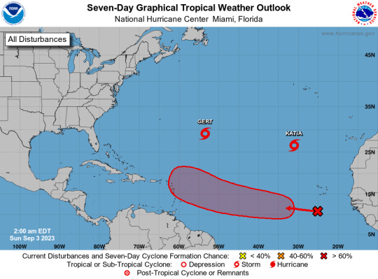
Active Systems: The National Hurricane Center is issuing advisories on Tropical Storm Gert, located about 700 miles east-southeast of Bermuda, and Tropical Storm Katia, located about 850 miles north-northwest of the Cabo Verde Islands. Eastern and Central Tropical Atlantic (AL95): A tropical wave located over the far eastern tropical Atlantic is producing disorganized shower and thunderstorm activity to the south-southwest of the Cabo Verde Islands. Environmental conditions appear conducive for some gradual development of this system by the middle part of this week, and a tropical depression is likely to form while it moves westward to west-northwestward at 15 to 20 mph over the eastern and central portions of the tropical Atlantic.
* Formation chance through 48 hours...low...30 percent.
* Formation chance through 7 days...high...70 percent.
$$ Forecaster Pasch
#bot post#meteorology#weather#tropical weather#tropical storm#tropical depression#hurricane#atlantic#atlantic ocean#caribbean#gulf of mexico#noaa#national oceanic and atmospheric administration#nhc#national hurricane center
44 notes
·
View notes
Text
Atlantic Tropical Weather Outlook issued by the National Hurricane Center in Miami, FL, USA
2023-09-28, 14:00 EDT

Active Systems: The National Hurricane Center is issuing advisories on Tropical Storm Philippe, located several hundred miles east of the northern Leeward Islands, and on newly formed Tropical Storm Rina located over the tropical central Atlantic.
&& Public Advisories on Tropical Storm Rina are issued under WMO header WTNT33 KNHC and under AWIPS header MIATCPAT3. Forecast/Advisories on Tropical Storm Rina are issued under WMO header WTNT23 KNHC and under AWIPS header MIATCMAT3.
$$ Forecaster Cangialosi
#bot post#meteorology#weather#tropical weather#tropical storm#tropical depression#hurricane#atlantic#atlantic ocean#caribbean#gulf of mexico#noaa#national oceanic and atmospheric administration#nhc#national hurricane center
14 notes
·
View notes
Text
Atlantic Tropical Weather Outlook issued by the National Hurricane Center in Miami, FL, USA
2023-08-21, 02:00 EDT

Active Systems: The National Hurricane Center is issuing advisories recently upgraded Tropical Storm Gert, located several hundred miles east of the northern Leeward Islands, on Tropical Storm Emily, located a little over 1000 miles west-northwest of the Cabo Verde Islands, and on Tropical Storm Franklin, located over the eastern Caribbean Sea.
Western Gulf of Mexico (AL91): Showers and thunderstorms continue in association with a trough of low pressure located in the eastern Gulf of Mexico. Environmental conditions appear favorable for development of this system while it moves westward at about 15 to 20 mph across the central Gulf of Mexico. A tropical depression or storm is likely to form while it approaches the western Gulf of Mexico coastline by Tuesday. Interests in the western Gulf of Mexico should monitor the progress of this system. Tropical storm watches or warnings may be necessary on Monday for portions of the southern Texas and northern Mexico coastlines.
* Formation chance through 48 hours...high...70 percent.
* Formation chance through 7 days...high...70 percent.
Eastern Tropical Atlantic (AL92): A large area of disorganized showers and thunderstorms over the far eastern tropical Atlantic is associated with a tropical wave located near the Cabo Verde Islands. Environmental conditions appear conducive for gradual development of this system, and a tropical depression is likely to form later this week while it moves west-northwestward across the eastern tropical Atlantic.
* Formation chance through 48 hours...medium...40 percent.
* Formation chance through 7 days...high...70 percent.
&&
Public Advisories on Tropical Storm Emily are issued under WMO header WTNT32 KNHC and under AWIPS header MIATCPAT2. Forecast/Advisories on Tropical Storm Emily are issued under WMO header WTNT22 KNHC and under AWIPS header MIATCMAT2.
Public Advisories on Tropical Storm Franklin are issued under WMO header WTNT33 KNHC and under AWIPS header MIATCPAT3. Forecast/Advisories on Tropical Storm Franklin are issued under WMO header WTNT23 KNHC and under AWIPS header MIATCMAT3.
$$ Forecaster Roberts
#meteorology#bot post#weather#tropical weather#tropical storm#tropical depression#hurricane#atlantic#atlantic ocean#caribbean#gulf of mexico#noaa#national oceanic and atmospheric administration#nhc#national hurricane center
11 notes
·
View notes
Text
Atlantic Tropical Weather Outlook issued by the National Hurricane Center in Miami, FL, USA
2023-08-23, 14:00 EDT

Active Systems: The National Hurricane Center is issuing advisories on Tropical Storm Franklin, located inland over the Dominican Republic. The Weather Prediction Center has issued the final advisory on Post-Tropical Cyclone Harold, located inland over northern Mexico.
Central Subtropical Atlantic (Remnants of Emily): An area of low pressure more than 1000 miles miles northeast of the Leeward Islands (the remnants of former Tropical Storm Emily) continues to produce a large area of disorganized showers and thunderstorms northeast of its center. Upper-level winds are forecast to become more conducive for development by tomorrow, and this system is likely to regenerate into a tropical depression or tropical storm late this week or this weekend when the system moves northward over the subtropical central Atlantic. For additional information on this system, including gale warnings, see High Seas Forecasts issued by the National Weather Service.
* Formation chance through 48 hours...medium...60 percent.
* Formation chance through 7 days...high...70 percent.
Eastern Tropical Atlantic (AL92): Disorganized showers and thunderstorms continue in association with an area of low pressure located several hundred miles west of the Cabo Verde Islands. Environmental conditions appear only marginally favorable for some slow development through early next week while the system moves west-northwestward to northwestward into the central tropical Atlantic.
* Formation chance through 48 hours...low...10 percent.
* Formation chance through 7 days...low...30 percent.
&&
Information on Post-Tropical Cyclone Harold can be found in Public Advisories issued by the Weather Prediction Center, under AWIPS header TCPAT4, WMO header WTNT34 KWNH, and on the web at www.hurricanes.gov.
High Seas Forecasts issued by the National Weather Service can be found under AWIPS header NFDHSFAT1, WMO header FZNT01 KWBC, and online at ocean.weather.gov/shtml/NFDHSFAT1.php
$$ Forecaster Papin/R. Zelinsky
#meteorology#bot post#weather#tropical weather#tropical storm#tropical depression#hurricane#atlantic#atlantic ocean#caribbean#gulf of mexico#noaa#national oceanic and atmospheric administration#nhc#national hurricane center
11 notes
·
View notes
Text
Atlantic Tropical Weather Outlook issued by the National Hurricane Center in Miami, FL, USA
2023-11-06, 19:00 EST

Tropical cyclone formation is not expected during the next 7 days.
$$ Forecaster Bucci
#bot post#meteorology#weather#tropical weather#tropical storm#tropical depression#hurricane#atlantic#atlantic ocean#caribbean#gulf of mexico#noaa#national oceanic and atmospheric administration#nhc#national hurricane center
6 notes
·
View notes
Text
Atlantic Tropical Weather Outlook issued by the National Hurricane Center in Miami, FL, USA
2023-09-03, 14:00 EDT

Active Systems: The National Hurricane Center is issuing advisories on Tropical Storm Gert, located over the central subtropical Atlantic, and Tropical Storm Katia, located over the eastern subtropical Atlantic. Central Tropical Atlantic (AL95): Showers and thunderstorms associated with a tropical wave located several hundred miles southwest of the Cabo Verde Islands have become better organized since yesterday. Environmental conditions are forecast to be conducive for further development, and this system is expected to become a tropical depression around midweek. Additional strengthening is likely late this week while the system moves westward to west-northwestward at 15 to 20 mph over the central and western portions of the tropical Atlantic.
* Formation chance through 48 hours...medium...50 percent.
* Formation chance through 7 days...high...90 percent.
Eastern Tropical Atlantic: A tropical wave over western Africa is forecast to move offshore in a few days. Environmental conditions could support some slow development starting midweek while the wave moves to the west- northwestward at about 15 mph over the far eastern tropical Atlantic.
* Formation chance through 48 hours...low...near 0 percent.
* Formation chance through 7 days...low...30 percent.
$$ Forecaster Blake
#bot post#meteorology#weather#tropical weather#tropical storm#tropical depression#hurricane#atlantic#atlantic ocean#caribbean#gulf of mexico#noaa#national oceanic and atmospheric administration#nhc#national hurricane center
8 notes
·
View notes
Text
Atlantic Tropical Weather Outlook issued by the National Hurricane Center in Miami, FL, USA
2023-08-19, 14:00 EDT
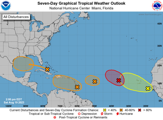
Eastern Tropical Atlantic (AL98): Shower and thunderstorm activity continues in association with a broad area of low pressure located several hundred miles west of the Cabo Verde Islands. Environmental conditions appear generally favorable for further development of this system, and a short-lived tropical depression is likely to form this weekend while it moves west-northwestward or northwestward at about 10 mph across the eastern tropical Atlantic. By early next week, upper-level winds over the system are forecast to increase, and further development is not expected.
* Formation chance through 48 hours...high...70 percent.
* Formation chance through 7 days...high...70 percent.
Central Tropical Atlantic (AL99): An area of low pressure located roughly halfway between the Cabo Verde Islands and the Lesser Antilles is producing disorganized showers and thunderstorms east of the center. While environmental conditions are only marginally conducive, a short-lived tropical depression could form in the next day or so while the system moves west-northwestward at 10 to 15 mph across the tropical Atlantic. After that time, additional development is not anticipated since upper-level winds are expected to become increasingly unfavorable.
* Formation chance through 48 hours...medium...50 percent.
* Formation chance through 7 days...medium...50 percent.
Near the Windward Islands (AL90): A broad area of low pressure has formed near the Windward Islands, shower and thunderstorm activity has become better organized since yesterday. Some additional development of this system is likely and a tropical depression could form by early next week while this system moves westward to west-northwestward at 10 to 15 mph, across the Lesser Antilles and over the eastern and central Caribbean Sea. Regardless of development, heavy rainfall is possible over portions of the Windward Islands during the next couple of days. Interests in the eastern and central Caribbean should monitor the progress of this system.
* Formation chance through 48 hours...medium...40 percent.
* Formation chance through 7 days...medium...60 percent.
Western Gulf of Mexico: An area of disturbed weather located near the northwestern and central Bahamas is expected to move into the Gulf of Mexico by early next week, where a broad area of low pressure is expected to form. Some slow development of this system is possible thereafter, and a tropical depression could form as it moves westward and approaches the western Gulf of Mexico coastline by the middle of next week.
* Formation chance through 48 hours...low...10 percent.
* Formation chance through 7 days...medium...50 percent.
Near the coast of Africa: A tropical wave located near the western coast of Africa is producing a large area of disorganized showers and thunderstorms. Some slow development is possible while it moves generally west-northwestward across the tropical eastern Atlantic during the next several days.
* Formation chance through 48 hours...low...near 0 percent.
* Formation chance through 7 days...low...20 percent.
$$ Forecaster Bucci/Papin/Cangialosi/Brennan
#meteorology#bot post#weather#tropical weather#tropical storm#tropical depression#hurricane#atlantic#atlantic ocean#caribbean#gulf of mexico#noaa#national oceanic and atmospheric administration#nhc#national hurricane center
10 notes
·
View notes
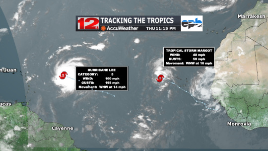
Text
Atlantic Tropical Weather Outlook issued by the National Hurricane Center in Miami, FL, USA
2023-09-08, 08:00 EDT

Active Systems: The National Hurricane Center is issuing advisories on Hurricane Lee, located several hundred miles east of the northern Leeward Islands, and on Tropical Storm Margot, located over the eastern tropical Atlantic.
Tropical cyclone formation is not expected during the next 7 days.
&&
Public Advisories on Margot are issued under WMO header WTNT34 KNHC and under AWIPS header MIATCPAT4. Forecast/Advisories on Margot are issued under WMO header WTNT24 KNHC and under AWIPS header MIATCMAT4.
$$ Forecaster Kelly
#bot post#meteorology#weather#tropical weather#tropical storm#tropical depression#hurricane#atlantic#atlantic ocean#caribbean#gulf of mexico#noaa#national oceanic and atmospheric administration#nhc#national hurricane center
6 notes
·
View notes
Text
Atlantic Tropical Weather Outlook issued by the National Hurricane Center in Miami, FL, USA
2023-07-15, 08:00 EDT

Active Systems: The National Hurricane Center is issuing advisories on Subtropical Storm Don, located over the central Atlantic.
Tropical cyclone formation is not expected during the next 7 days.
$$ Forecaster Blake
#meteorology#bot post#weather#tropical weather#tropical storm#tropical depression#hurricane#atlantic#atlantic ocean#caribbean#gulf of mexico#noaa#national oceanic and atmospheric administration#nhc#national hurricane center
7 notes
·
View notes
Last Seen Blogs