#oldmapsarecool
Explore tagged Tumblr posts
Visit Tumblr Blog
Explore Tumblr blogs with no restrictions, modern design and the best experience.
Last Seen Tumblr Blogs


Fun Fact
Mobile Tumblr US users spend an average of 4.04 minutes per session on the app.
Photo
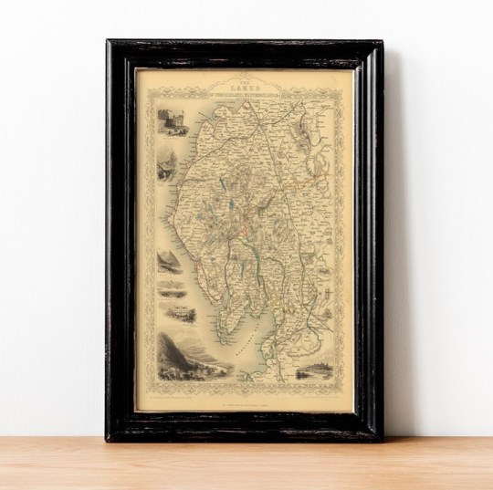
Happy Wednesday! Today we are taking a journey to the beautiful British region, The Lakes of Cumberland & Westmoreland. ⠀⠀⠀⠀⠀⠀⠀⠀⠀ Old Maps Library reprint is a striking and detailed regional map and it includes vignettes of Carlisle Castle, Skiddaw near Keswick, Ambleside, View From Low Door Inn, Drewent Water, Crown Hotel, Bowness Windermere, Newby Bridge Inn Windermere and Lancaster Castle. Published by John Tallis & engraved by John Rapkin, 1851 ⠀⠀⠀⠀⠀⠀⠀⠀⠀ John Tallis (1817-1876) was a British map publisher. Born in the Midlands, Tallis came to London in the 1840s and began his London career with a series of remarkable London street views. . . . #oldmaps #vintagemaps #britishisles #antiquemaps #britishcounties #thelakes #ilovehistory #instamaps #ukmaps #wallart #mapstagram #maplover #walldecorations #homeofficedecor #mapsandillustrations #oldmapsarecool #walldecorideas #location #oldmapslibrary #retromap #mapshop #ilovemaps #historicalmap #mapsoftheworld #amazingmaps #antiquemapsandprints #framedmaps #wallframes #vintagemapsforsale #mapcollector (at London, Unιted Kingdom) https://www.instagram.com/p/CNXkCyxlefd/?igshid=6wwewx5pj3hw
#oldmaps#vintagemaps#britishisles#antiquemaps#britishcounties#thelakes#ilovehistory#instamaps#ukmaps#wallart#mapstagram#maplover#walldecorations#homeofficedecor#mapsandillustrations#oldmapsarecool#walldecorideas#location#oldmapslibrary#retromap#mapshop#ilovemaps#historicalmap#mapsoftheworld#amazingmaps#antiquemapsandprints#framedmaps#wallframes#vintagemapsforsale#mapcollector
2 notes
·
View notes
Photo

1940’s map of Kansas by French artist Jaques Liozu. The depictions of the local people and industries are playful and fun! -and dated. #kansas #kansascity #1940s #pictorial #oldmapsandprints ##oldmaps #oldmapsarecool #etsyshop #etsyfinds #cartography #cartografia #mapofkansas (at Olympia, Washington) https://www.instagram.com/p/B8E65F9nZ9B/?igshid=1oaqyhsvn0ij9
#kansas#kansascity#1940s#pictorial#oldmapsandprints#oldmaps#oldmapsarecool#etsyshop#etsyfinds#cartography#cartografia#mapofkansas
12 notes
·
View notes
Photo
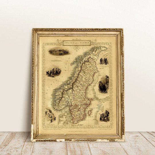
Hello you! Where is your favourite place in the world? Where is your dream destination? ⠀⠀⠀⠀⠀⠀⠀⠀⠀ Bring those memories or keep your travel dream alive with a beautiful old map like this one from SWEDEN & NORWAY, 1851 by John Tallis. ⠀⠀⠀⠀⠀⠀⠀⠀⠀ This map of Sweden and Norway has a number of vignette views including Stockholm, Swedish peasants and Norwegian Laplanders in winter dress, the iron mine of Dannemora and Norwegian ‘skielobere’, or Skate runners. The map was drawn and engraved by John Rapkin while the illustrations are drawn by J.Marchant and engraved by J. H. Kernot and published in John Tallis & co.’s The Illustrated Atlas. ⠀⠀⠀⠀⠀⠀⠀⠀⠀ "Travel back to moments in time and discover the world heritage!" ⠀⠀⠀⠀⠀⠀⠀⠀⠀ Visit our online store! www.oldmapslibrary.com . . . . #oldmapsarecool #walldecorideas #swedenmap #norwaymap #ilovemaps (at London, Unιted Kingdom) https://www.instagram.com/p/CixcK2hItpr/?igshid=NGJjMDIxMWI=
0 notes
Photo
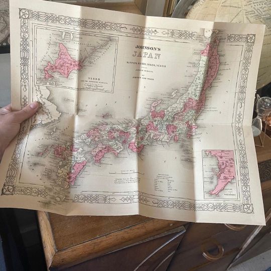
Have in your house a piece of the past with one of our historical map of your favourite place in the world!⠀⠀⠀⠀⠀⠀⠀⠀⠀
Japan by A.J Johnson, 1864, from Johnson’s New Illustrated Family Atlas of the World. ⠀⠀⠀⠀⠀⠀⠀⠀⠀
JAPAN – Nippon, Kiusiu, Sikov, Yesso, and the Japanese Kuriles by Johnson and Ward. ⠀⠀⠀⠀⠀⠀⠀⠀⠀
Old Maps Library - Travel back to moments in time and discover the world heritage!
0 notes
Photo

Happy Friday! ⠀⠀⠀⠀⠀⠀⠀⠀⠀ During the 15th and 16th centuries, Portugal became a leading European power that ranked with England, France and Spain in terms of economic, political and cultural influence. The Portuguese were great navegators and had an extensive colonial trading empire throughout the world ⠀⠀⠀⠀⠀⠀⠀⠀⠀ Old Maps Library reprint map of Portugal, 1736 by Herman Moll. ⠀⠀⠀⠀⠀⠀⠀⠀⠀ ⏳Old Maps Library specialises in the reprint of Vintage Maps and Illustrations between the 17th to 19th centuries. ⠀⠀⠀⠀⠀⠀⠀⠀⠀ ⠀⠀⠀⠀⠀⠀⠀⠀⠀ ⏳ We have a beautiful collection of Old Maps and Vintage Illustrations on our website. Link on our bio. . . . . #oldmaps #vintagemaps #antiquemaps #instamaps #maps #wallart #mapstagram #maplover #mapsandillustrations #oldmapsarecool #oldmapslibrary #retromap #mapshop #ilovemaps (at London, Unιted Kingdom) https://www.instagram.com/p/Cc7xunlOkex/?igshid=NGJjMDIxMWI=
#oldmaps#vintagemaps#antiquemaps#instamaps#maps#wallart#mapstagram#maplover#mapsandillustrations#oldmapsarecool#oldmapslibrary#retromap#mapshop#ilovemaps
0 notes
Photo
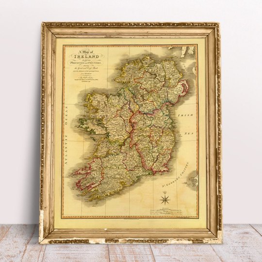
Happy Thursday! Happy Saint Patrick's Day, patron saint of Ireland!🍀 He was born in Roman Britain in the late 4th century, and he was kidnapped at the age of 16 and taken to Ireland as a slave. He escaped but returned about 432 CE to convert the Irish to Christianity. By the time of his death on March 17, 461, he had established monasteries, churches, and schools. Many legends grew up around him—for example, that he drove the snakes out of Ireland and used the shamrock ☘️to explain the Trinity. ⠀⠀⠀⠀⠀⠀⠀⠀⠀ To celebrate today a gorgeous Ireland Map, 1798 by William Faden. Reprint Old Maps Library, 2022. ⠀⠀⠀⠀⠀⠀⠀⠀⠀ ⏳ Old Maps Library specialises in the reprint of Vintage Maps and Illustrations between the 17th to 19th centuries. ⠀⠀⠀⠀⠀⠀⠀⠀⠀ 🔎 Our prints are linen backed by hand, this technique gives it more durability and a beautiful vintage finish look. ⠀⠀⠀⠀⠀⠀⠀⠀⠀ ⏳Linen backing is a technique that mapmakers used in the past as a solution to keep the maps stronger for long journeys and weather changes. ⠀⠀⠀⠀⠀⠀⠀⠀⠀ 🔎Nowadays, this technique is an important conservation method for restoring and preserving vintage maps and posters. ⠀⠀⠀⠀⠀⠀⠀⠀⠀ ⏳Our maps are folded and fitted into a marbled slipcase. ⠀⠀⠀⠀⠀⠀⠀⠀⠀ ⏳ ⠀⠀⠀⠀⠀⠀⠀⠀⠀ Are you also fascinated by old maps? ⠀⠀⠀⠀⠀⠀⠀⠀⠀ ⏳ ⠀⠀⠀⠀⠀⠀⠀⠀⠀ "Travel back to moments in time and discover the world heritage!" ⠀⠀⠀⠀⠀⠀⠀⠀⠀ ⏳ We have a beautiful collection of Old Maps and Vintage Illustrations on our website. Link on our bio. . . . #oldmaps #vintagemaps #irelandmap #haritalar #ilovehistory #instamaps #maps #wallart #mapstagram #maplover #walldecorations #homeofficedecor #mapsandillustrations #oldmapsarecool #walldecorideas #saintpatrickday #oldmapslibrary #retromap #mapshop #ilovemaps #mapsoftheworld #amazingmaps #antiquemapsandprints #framedmaps #wallframes #vintagemapsforsale #mapcollector (at London, Unιted Kingdom) https://www.instagram.com/p/CbNlJw_IpDN/?utm_medium=tumblr
#oldmaps#vintagemaps#irelandmap#haritalar#ilovehistory#instamaps#maps#wallart#mapstagram#maplover#walldecorations#homeofficedecor#mapsandillustrations#oldmapsarecool#walldecorideas#saintpatrickday#oldmapslibrary#retromap#mapshop#ilovemaps#mapsoftheworld#amazingmaps#antiquemapsandprints#framedmaps#wallframes#vintagemapsforsale#mapcollector
0 notes
Photo

Hi everyone, Xīnnián hǎo! Happy Chinese New Year! 🐅 ⠀⠀⠀⠀⠀⠀⠀⠀⠀ Chinese New Year, also known as the Lunar New Year, is the festival that celebrates the beginning of a new year on the traditional lunisolar and solar Chinese calendar. ⠀⠀⠀⠀⠀⠀⠀⠀⠀ This year is the Year of the Tiger, the first since 2010. Tigers are know for being courageous and competitive, always ready for a challenge. However, they are also believed to be rebellious and short-tempered, and can sometimes be unpredictable. ⠀⠀⠀⠀⠀⠀⠀⠀⠀ Old Maps Library reprint map of China, 1855. Coloured by provinces. Inset maps of Canton and Amoy. Shows Formosa and many Islands in the China Sea and Pacific, a terrific regional map. Published in the 1869 Colton General Atlas by G. W. & C. B. Colton. ⠀⠀⠀⠀⠀⠀⠀⠀⠀ ⏳ Old Maps Library specialises in the reprint of Vintage Maps and Illustrations between the 17th to 19th centuries. ⠀⠀⠀⠀⠀⠀⠀⠀⠀ 🔎 Our prints are linen backed by hand, this technique gives it more durability and a beautiful vintage finish look. ⠀⠀⠀⠀⠀⠀⠀⠀⠀ ⏳Linen backing is a technique that mapmakers used in the past as a solution to keep the maps stronger for long journeys and weather changes. ⠀⠀⠀⠀⠀⠀⠀⠀⠀ 🔎Nowadays, this technique is an important conservation method for restoring and preserving vintage maps and posters. ⠀⠀⠀⠀⠀⠀⠀⠀⠀ ⏳Our maps are folded and fitted into a marbled slipcase. ⠀⠀⠀⠀⠀⠀⠀⠀⠀ ⏳ ⠀⠀⠀⠀⠀⠀⠀⠀⠀ Are you also fascinated by old maps? ⠀⠀⠀⠀⠀⠀⠀⠀⠀ ⏳ ⠀⠀⠀⠀⠀⠀⠀⠀⠀ "Travel back to moments in time and discover the world heritage!" ⠀⠀⠀⠀⠀⠀⠀⠀⠀ ⏳ We have a beautiful collection of Old Maps and Vintage Illustrations on our website. Link on our bio. . . . . #maplover #mapsandillustrations #oldmapsarecool #oldmapslibrary #retromap #mapshop #ilovemaps #mapofchina (at London, Unιted Kingdom) https://www.instagram.com/p/CZcOh7QIbrA/?utm_medium=tumblr
0 notes
Photo

“A map is the greatest of all epic poems. Its line and colours show the realisation of great dreams." - Gilbert H. Grosvenor - ⠀⠀⠀⠀⠀⠀⠀⠀⠀ As human beings, we all have our own values, beliefs and attitudes that we have developed throughout the course of our lives. ⠀⠀⠀⠀⠀⠀⠀⠀⠀ Our ancestors, family, friends, community and the experiences we have had all contribute to our sense of who we are and how we view the world. ⠀⠀⠀⠀⠀⠀⠀⠀⠀ Ancient maps take us through a journey back in time and remind us of our knowledge and our perception of the world. ⠀⠀⠀⠀⠀⠀⠀⠀⠀ The history illustrated in maps are not merely geographical, but also a perceptual history of how we see the world, each other, and, ultimately, ourselves. ⠀⠀⠀⠀⠀⠀⠀⠀⠀ ⠀⠀⠀⠀⠀⠀⠀⠀⠀ "Travel Back to Moments in time and Discover the World heritage”! ⠀⠀⠀⠀⠀⠀⠀⠀⠀ ⠀⠀⠀⠀⠀⠀⠀⠀⠀ ⏳Old Maps Library specialises in the reprint of Vintage Maps and Illustrations between the 17th to 19th centuries. ⠀⠀⠀⠀⠀⠀⠀⠀⠀ ⏳We have a beautiful collection on our website. Link on our bio. . . . . #oldmaps #vintagemaps #antiquemaps #cartography #haritalar #ilovehistory #instamaps #maps #maplover #mapsandillustrations #oldmapsarecool #oldmapslibrary #retromap #ilovemaps #quoteofday (at London, Unιted Kingdom) https://www.instagram.com/p/CVc28wiodqr/?utm_medium=tumblr
#oldmaps#vintagemaps#antiquemaps#cartography#haritalar#ilovehistory#instamaps#maps#maplover#mapsandillustrations#oldmapsarecool#oldmapslibrary#retromap#ilovemaps#quoteofday
0 notes
Photo

Happy Tuesday! Wherever you are I hope you are having a great day. Over here at Old Maps Library we are busy getting ready to go to the beautiful Edinburgh. We are going to be there from the 7th to 29th of August at the West End Fair, Prince Street, during Fringe Festival. We are counting the days & are very excited to go back! ⠀⠀⠀⠀⠀⠀⠀⠀⠀ If by any chance you are around Scotland this month, come and visit us in the Arch's of Saint Johns Church grounds. ⠀⠀⠀⠀⠀⠀⠀⠀⠀ " Travel back in time & Discover the World heritage" ⠀⠀⠀⠀⠀⠀⠀⠀⠀ ⏳ Old Maps Library specialises in the reprint of Vintage Maps and Illustrations between the 17th to 19th centuries. ⠀⠀⠀⠀⠀⠀⠀⠀⠀ 🔎 Our prints are linen backed by hand, this technique gives it more durability and a beautiful vintage finish look. ⠀⠀⠀⠀⠀⠀⠀⠀⠀ ⏳Linen backing is a technique that mapmakers used in the past as a solution to keep the maps stronger for long journeys and weather changes. ⠀⠀⠀⠀⠀⠀⠀⠀⠀ 🔎Nowadays, this technique is an important conservation method for restoring and preserving vintage maps and posters. ⠀⠀⠀⠀⠀⠀⠀⠀⠀ ⏳Our maps are folded and fitted into a marbled slipcase. ⠀⠀⠀⠀⠀⠀⠀⠀⠀ ⏳ We have a beautiful collection of Old Maps and Vintage Illustrations on our website. Link in our bio. . . . #oldmaps #vintagemaps #westendfair #3d2devents #antiquemaps #3d2d #ilovehistory #instamaps #maps #wallart #mapstagram #maplover #walldecorations #homeofficedecor #mapsandillustrations #oldmapsarecool #walldecorideas #fringefestival #oldmapslibrary #retromap #mapshop #ilovemaps #historicalmap #mapsoftheworld #amazingmaps #antiquemapsandprints #framedmaps #wallframes #vintagemapsforsale #mapcollector (at Edinburgh, Scotland) https://www.instagram.com/p/CSHTR7sIyL7/?utm_medium=tumblr
#oldmaps#vintagemaps#westendfair#3d2devents#antiquemaps#3d2d#ilovehistory#instamaps#maps#wallart#mapstagram#maplover#walldecorations#homeofficedecor#mapsandillustrations#oldmapsarecool#walldecorideas#fringefestival#oldmapslibrary#retromap#mapshop#ilovemaps#historicalmap#mapsoftheworld#amazingmaps#antiquemapsandprints#framedmaps#wallframes#vintagemapsforsale#mapcollector
0 notes
Photo

Happy Wednesday! ⠀⠀⠀⠀⠀⠀⠀⠀⠀ I looooooove maps! Do you? To me ancient maps are filled with history and memories. It is a perfect gift! Having a framed old map of your favourite place will create a beautiful piece to keep the travel dreams and make your home really special. ⠀⠀⠀⠀⠀⠀⠀⠀⠀ London Map - Mogg's Strangers Guide to London, 1834 reprint by Old Maps Library, 2021. ⠀⠀⠀⠀⠀⠀⠀⠀⠀ ⏳ Old Maps Library specialises in the reprint of Vintage Maps and Illustrations between the 17th to 19th centuries. ⠀⠀⠀⠀⠀⠀⠀⠀⠀ 🔎 Our prints are linen backed by hand, this technique gives it more durability and a beautiful vintage finish look. ⠀⠀⠀⠀⠀⠀⠀⠀⠀ ⏳Linen backing is a technique that mapmakers used in the past as a solution to keep the maps stronger for long journeys and weather changes. ⠀⠀⠀⠀⠀⠀⠀⠀⠀ 🔎Nowadays, this technique is an important conservation method for restoring and preserving vintage maps and posters. ⠀⠀⠀⠀⠀⠀⠀⠀⠀ ⏳Our maps are folded and fitted into a marbled slipcase. ⠀⠀⠀⠀⠀⠀⠀⠀⠀ ⏳ We have a beautiful collection of Old Maps and Vintage Illustrations on our website. 🔝Link in our bio. . . . . . . #oldmaps #vintagemaps #londmap #antiquemaps #mapoflondon #haritalar #ilovehistory #instamaps #maps #wallart #mapstagram #maplover #walldecorations #homeofficedecor #mapsandillustrations #oldmapsarecool #walldecorideas #citymap #oldmapslibrary #retromap #mapshop #ilovemaps #historicalmap #mapsoftheworld #amazingmaps #antiquemapsandprints #framedmaps #wallframes #vintagemapsforsale #mapcollector (at London, Unιted Kingdom) https://www.instagram.com/p/CR34ivRNfuB/?utm_medium=tumblr
#oldmaps#vintagemaps#londmap#antiquemaps#mapoflondon#haritalar#ilovehistory#instamaps#maps#wallart#mapstagram#maplover#walldecorations#homeofficedecor#mapsandillustrations#oldmapsarecool#walldecorideas#citymap#oldmapslibrary#retromap#mapshop#ilovemaps#historicalmap#mapsoftheworld#amazingmaps#antiquemapsandprints#framedmaps#wallframes#vintagemapsforsale#mapcollector
0 notes
Photo

Happy Wednesday! Old maps have been part of human history for thousands of years. The oldest known world map, the Imago Mundi, was chiselled on a clay tablet in ancient Babylon in 6 B.C. ⠀⠀⠀⠀⠀⠀⠀⠀⠀ To me ancient maps have the magic of taking us back in time and see the birth of the modern world. It takes us on a journey through the eyes of historians and cartographers, and where they've imprinted their dreams and draw their ideas. ⠀⠀⠀⠀⠀⠀⠀⠀⠀ Here at Old Maps Library, we love how we can use an old map to explore the history of a new world, and what we can learn about the people who created them, and the romance of parts still unknown to us. ⠀⠀⠀⠀⠀⠀⠀⠀⠀ So, as Kevin J. Brown said: "Ancient maps are a touching reminder that our knowledge and our perception of the world are abundant and limited at the same time". ⠀⠀⠀⠀⠀⠀⠀⠀⠀ Are you also fascinated by old maps? It is a perfect gift filled with history and memories or an amazing keepsake from unique and breathtaking places around the world. ⠀⠀⠀⠀⠀⠀⠀⠀⠀ Old Maps Library has been trading since 2015. We are specialised in the reprint of unique Old Maps & Vintage Illustrations from the 17th to 19th centuries. Our products are mounted on linen by hand, a technique that has been used in cartography for centuries. This process gives our maps and illustrations a beautiful vintage look and more durability. Maps are folded and fitted into a marbled slipcase. ⠀⠀⠀⠀⠀⠀⠀⠀⠀ Old Maps Library - "Travel Back in Time and Discover the World Heritage!" . ⠀⠀⠀⠀⠀⠀⠀⠀⠀ #oldmaps #vintagemaps #britishempire #antiquemaps #londonmap #haritalar #ilovehistory #instamaps #maps #wallart #mapstagram #maplover #walldecorations #mapsandillustrations #oldmapsarecool #walldecorideas #greatbritainmap #oldmapslibrary #retromap #mapshop #ilovemaps #historicalmap #mapsoftheworld #amazingmaps #antiquemapsandprints #framedmaps #wallframes #vintagemapsforsale #mapcollector (at London, Unιted Kingdom) https://www.instagram.com/p/CRT6z_tthJq/?utm_medium=tumblr
#oldmaps#vintagemaps#britishempire#antiquemaps#londonmap#haritalar#ilovehistory#instamaps#maps#wallart#mapstagram#maplover#walldecorations#mapsandillustrations#oldmapsarecool#walldecorideas#greatbritainmap#oldmapslibrary#retromap#mapshop#ilovemaps#historicalmap#mapsoftheworld#amazingmaps#antiquemapsandprints#framedmaps#wallframes#vintagemapsforsale#mapcollector
0 notes
Photo
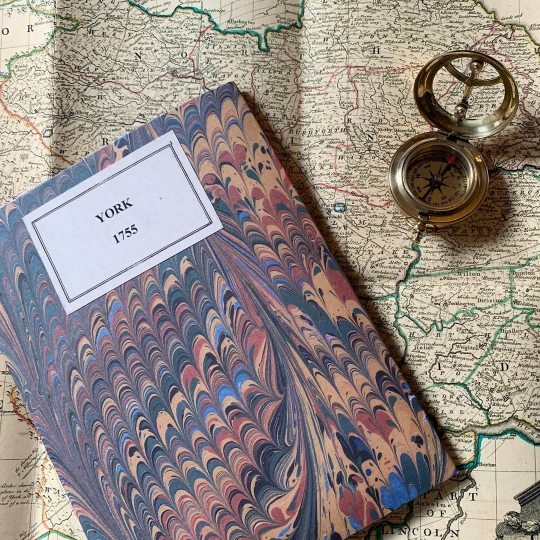
Happy Monday! Did you know that the city of York began in 71AD with the Romans? But, archaeological evidence suggests that settlements around York date back to the Mesolithic period. It had many names. The Romans knew it as Eboracum. To the Saxons it was Eoforwick. The Vikings, who came as invaders but stayed on in settlements, called it Jorvik. King George the VI used to say: "The History of York is the history of England." ⠀⠀⠀⠀⠀⠀⠀⠀⠀ Old Maps Library has a gorgeous reprint map of YORK, 1755 by Emanuel Bowen. ⠀⠀⠀⠀⠀⠀⠀⠀⠀ ⏳ ⠀⠀⠀⠀⠀⠀⠀⠀⠀ ⏳ Old Maps Library specialises in the reprint of Vintage Maps and Illustrations between the 17th to 19th centuries. ⠀⠀⠀⠀⠀⠀⠀⠀⠀ 🔎 Our prints are linen backed by hand, this technique gives it more durability and a beautiful vintage finish look. ⠀⠀⠀⠀⠀⠀⠀⠀⠀ ⏳Linen backing is a technique that mapmakers used in the past as a solution to keep the maps stronger for long journeys and weather changes. ⠀⠀⠀⠀⠀⠀⠀⠀⠀ 🔎Nowadays, this technique is an important conservation method for restoring and preserving vintage maps and posters. ⠀⠀⠀⠀⠀⠀⠀⠀⠀ ⏳Our maps are folded and fitted into a marbled slipcase. ⠀⠀⠀⠀⠀⠀⠀⠀⠀ ⠀⠀⠀⠀⠀⠀⠀⠀⠀ Are you also fascinated by old maps? We have a beautiful collection of Old Maps and Vintage Illustrations on our website. 🔝 Link in our bio. . . . #oldmaps #vintagemaps #britishhistory #antiquemaps #mapofyork #haritalar #ilovehistory #instamaps #maps #wallart #mapstagram #maplover #walldecorations #mapofyork #mapsandillustrations #oldmapsarecool #walldecorideas #countymaps #oldmapslibrary #retromap #mapshop #ilovemaps #historicalmap #mapsoftheworld #amazingmaps #antiquemapsandprints #framedmaps #wallframes #vintagemapsforsale #mapcollector (at London, Unιted Kingdom) https://www.instagram.com/p/CROc9h4Nuz4/?utm_medium=tumblr
#oldmaps#vintagemaps#britishhistory#antiquemaps#mapofyork#haritalar#ilovehistory#instamaps#maps#wallart#mapstagram#maplover#walldecorations#mapsandillustrations#oldmapsarecool#walldecorideas#countymaps#oldmapslibrary#retromap#mapshop#ilovemaps#historicalmap#mapsoftheworld#amazingmaps#antiquemapsandprints#framedmaps#wallframes#vintagemapsforsale#mapcollector
0 notes
Photo

The idea is not to live forever, but to create something that will. - Andy Warhol - ⠀⠀⠀⠀⠀⠀⠀⠀⠀ Cartography is the art and science of making maps. Map making has been part of our history for thousands of years. The oldest know world map the Imago Mundi was chiselled on a clay tablet in ancient Babylon in 6 B.C. Ancient Greeks in 4 B.C had similar maps though they correctly believed that the earth was not flat, but a sphere. It was Gerardus Mercator, a Flemish Geographer, that drawn by hand on paper the first reasonably accurate world map in 1569. His world map was based on a new projection which represented sailing courses of constant bearing as straight lines—an innovation that is still employed in nautical charts. ⠀⠀⠀⠀⠀⠀⠀⠀⠀ Old maps are a special treasure that allow us to see the birth of the modern world through it. We absolutely love it! Anyone else loves old maps? ⠀⠀⠀⠀⠀⠀⠀⠀⠀ ⏳ ⠀⠀⠀⠀⠀⠀⠀⠀⠀ "Travel back to moments in time and discover the world heritage!" ⠀⠀⠀⠀⠀⠀⠀⠀⠀ ⠀⠀⠀⠀⠀⠀⠀⠀⠀ ⏳Old Maps Library specialises in the reprint of Vintage Maps and Illustrations between the 17th to 19th centuries. ⠀⠀⠀⠀⠀⠀⠀⠀⠀ ⏳We have a beautiful collection on our website. Link on our bio. . . . #oldmaps #vintagemaps #worldmaps #antiquemaps #cartography #haritalar #ilovehistory #instamaps #maps #wallart #mapstagram #maplover #walldecoration #citymaps #londonmaps #mapsandillustrations #oldmapsarecool #walldecorideas #countrymaps #oldmapslibrary #retromap #mapshop #ilovemaps #historicalmap #mapsoftheworld #amazingmaps #antiquemapsandprints #framedmaps #vintagemapsforsale #mapcollector (at London, Unιted Kingdom) https://www.instagram.com/p/CQvxuThtF3u/?utm_medium=tumblr
#oldmaps#vintagemaps#worldmaps#antiquemaps#cartography#haritalar#ilovehistory#instamaps#maps#wallart#mapstagram#maplover#walldecoration#citymaps#londonmaps#mapsandillustrations#oldmapsarecool#walldecorideas#countrymaps#oldmapslibrary#retromap#mapshop#ilovemaps#historicalmap#mapsoftheworld#amazingmaps#antiquemapsandprints#framedmaps#vintagemapsforsale#mapcollector
1 note
·
View note
Photo

Happy Monday! London history extends over 2000 years, and in that time, it has become one of the world's most significant financial and cultural capital cities. ⠀⠀⠀⠀⠀⠀⠀⠀⠀ But, the city looked very different in the 18th century. London was dirty, noisy, and overcrowded. It had about 600,000 people around 1700 and almost a million residents in 1800. The rich, only a tiny minority of the population, lived luxuriously in lavish, elegant mansions and country houses, which they furnished with comfortable, upholstered furniture. ⠀⠀⠀⠀⠀⠀⠀⠀⠀ How about take a trip with us to 18th century London? We have for you this gorgeous map of Thomas Bowle's, 1794. ⠀⠀⠀⠀⠀⠀⠀⠀⠀ BOWLE’S New Pocket Plan of the Cities of London and Westminster with the Borough of Southwark: comprehending their Outskirts and Extent of the Thames from Chelsea to Deptford, exhibiting also the New Buildings, Roads and other Alterations to the year 1794. Detailed plan of Eighteenth-century London. Superb detail throughout often noting individual buildings, gardens, and estates. Table along the bottom notes principal buildings and churches. Bowles first issued this plan in 1777 and updated it regularly to the end of the 18th century. ⠀⠀⠀⠀⠀⠀⠀⠀⠀ ⏳ We have this beautiful map & more in our collection. Visit our website. 🔝 Link in our bio. . . . #oldmaps #vintagemaps #britishempire #antiquemaps #londonmap #mapoflondon #ilovehistory #instamaps #maps #wallart #mapstagram #maplover #walldecorations #homeofficedecor #mapsandillustrations #oldmapsarecool #walldecorideas #riverthames #oldmapslibrary #retromap #mapshop #ilovemaps #historicalmap #mapsoftheworld #amazingmaps #antiquemapsandprints #framedmaps #wallframes #vintagemapsforsale #mapcollector (at London, Unιted Kingdom) https://www.instagram.com/p/CQYvgHstVZa/?utm_medium=tumblr
#oldmaps#vintagemaps#britishempire#antiquemaps#londonmap#mapoflondon#ilovehistory#instamaps#maps#wallart#mapstagram#maplover#walldecorations#homeofficedecor#mapsandillustrations#oldmapsarecool#walldecorideas#riverthames#oldmapslibrary#retromap#mapshop#ilovemaps#historicalmap#mapsoftheworld#amazingmaps#antiquemapsandprints#framedmaps#wallframes#vintagemapsforsale#mapcollector
0 notes
Photo

Good Friday vibes! To celebrate the end of the week we are sharing with you a new addition to our shop. ⠀⠀⠀⠀⠀⠀⠀⠀⠀ A beautiful reprint map of POLAND, 1808. Extending from Prussia in the west to Smolensk in the east. Highly detailed. Divided into the regions controlled by Prussia, Russia and Austria. ⠀⠀⠀⠀⠀⠀⠀⠀⠀ The original map is part of a General Atlas - Collection of Maps of the World And Quarters, the Principal Empires, Kingdoms &c. with their several Provinces & other Subdivisions, Correctly Delineated. Published 1800, by Robert Wilkinson. ⠀⠀⠀⠀⠀⠀⠀⠀⠀ ⏳Robert Wilkinson was a commercial map maker in London in the late 18th and early 19th Centuries. Wilkinson's work as a mapmaker was primarily as a compiler of information from other sources. He was better known for his work as a printmaker and publisher of books. ⠀⠀⠀⠀⠀⠀⠀⠀⠀ ⏳Old Maps Library specialises in the reprint of Vintage Maps and Illustrations between the 17th to 19th centuries. ⠀⠀⠀⠀⠀⠀⠀⠀⠀ ⏳ We have a beautiful collection of Old Maps and Vintage Illustrations on our website. Link in our bio. . . . #oldmaps #vintagemaps #polandmap #antiquemaps #mapofpoland #haritalar #ilovehistory #instamaps #maps #wallart #mapstagram #maplover #walldecorations #homeofficedecor #mapsandillustrations #oldmapsarecool #walldecorideas #countrymap #oldmapslibrary #retromap #mapshop #ilovemaps #historicalmap #mapsoftheworld #amazingmaps #antiquemapsandprints #framedmaps #wallframes #vintagemapsforsale #mapcollector (at London, Unιted Kingdom) https://www.instagram.com/p/CO27MXBt8fp/?igshid=b469ph4vbdmg
#oldmaps#vintagemaps#polandmap#antiquemaps#mapofpoland#haritalar#ilovehistory#instamaps#maps#wallart#mapstagram#maplover#walldecorations#homeofficedecor#mapsandillustrations#oldmapsarecool#walldecorideas#countrymap#oldmapslibrary#retromap#mapshop#ilovemaps#historicalmap#mapsoftheworld#amazingmaps#antiquemapsandprints#framedmaps#wallframes#vintagemapsforsale#mapcollector
1 note
·
View note
Photo
Happy Tuesday! ⠀⠀⠀⠀⠀⠀⠀⠀⠀ How about having a beautiful old map from where you live or your favourite place in your living room? It would make your home even more especial. ❤️ ⠀⠀⠀⠀⠀⠀⠀⠀⠀ Map of HARTFORDSHIRE - A reprint of a new Improved Map of the best surveys & intelligence, divided into its Hundreds; Shewing the Several roads, & true measured distances between Town & Town. Also the rectories & vicarages; the parks and seats of nobility and Gentry; with other useful particulars By Thomas Kitchin, Geographer, year 1755. ⠀⠀⠀⠀⠀⠀⠀⠀⠀ ⏳ Old Maps Library specialises in the reprint of Vintage Maps and Illustrations between the 17th to 19th centuries. Our prints are linen backed by hand, a technique that mapmakers used in the past to keep maps stronger for long journeys and weather changes. Nowadays, this technique is an important conservation method for restoring and preserving vintage maps and posters. ⠀⠀⠀⠀⠀⠀⠀⠀⠀ "Travel back to moments in time and discover the world heritage!" ⠀⠀⠀⠀⠀⠀⠀⠀⠀ ⏳ We have a beautiful collection of Old Maps and Vintage Illustrations on our website. Link in our bio. . . . . . #oldmaps #vintagemaps #countymap #antiquemaps #cartography #haritalar #ilovehistory #instamaps #maps #wallart #mapstagram #maplover #walldecorations #homeofficedecor #mapsandillustrations #oldmapsarecool #walldecorideas #ukcountiesmap #oldmapslibrary #retromap #mapshop #ilovemaps #historicalmap #mapsoftheworld #amazingmaps #antiquemapsandprints #framedmaps #wallframes #vintagemapsforsale #mapcollector (at London, Unιted Kingdom) https://www.instagram.com/p/COdKcOLFzpG/?igshid=1f1isnrylhu1v
#oldmaps#vintagemaps#countymap#antiquemaps#cartography#haritalar#ilovehistory#instamaps#maps#wallart#mapstagram#maplover#walldecorations#homeofficedecor#mapsandillustrations#oldmapsarecool#walldecorideas#ukcountiesmap#oldmapslibrary#retromap#mapshop#ilovemaps#historicalmap#mapsoftheworld#amazingmaps#antiquemapsandprints#framedmaps#wallframes#vintagemapsforsale#mapcollector
0 notes