#ukmaps
Explore tagged Tumblr posts
Visit Tumblr Blog
Explore Tumblr blogs with no restrictions, modern design and the best experience.
Last Seen Tumblr Blogs


Fun Fact
Tumblr Inc. has $15.1M in annual revenue.
Text
Plan your UK trip, detailed maps guide you
1 note
·
View note
Photo
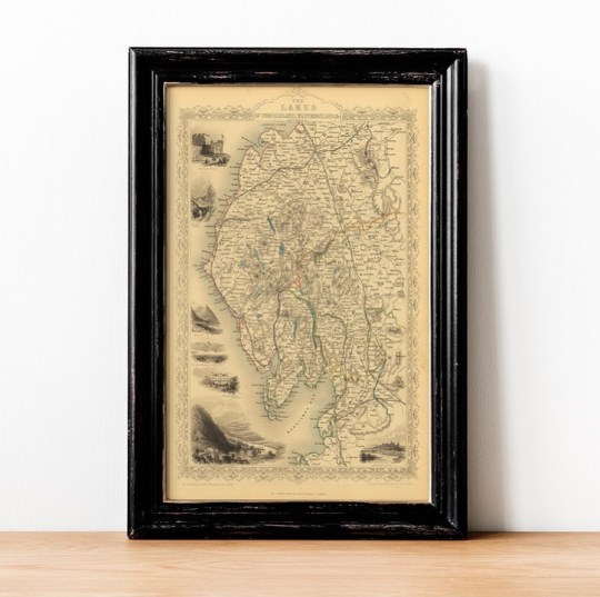
Happy Wednesday! Today we are taking a journey to the beautiful British region, The Lakes of Cumberland & Westmoreland. ⠀⠀⠀⠀⠀⠀⠀⠀⠀ Old Maps Library reprint is a striking and detailed regional map and it includes vignettes of Carlisle Castle, Skiddaw near Keswick, Ambleside, View From Low Door Inn, Drewent Water, Crown Hotel, Bowness Windermere, Newby Bridge Inn Windermere and Lancaster Castle. Published by John Tallis & engraved by John Rapkin, 1851 ⠀⠀⠀⠀⠀⠀⠀⠀⠀ John Tallis (1817-1876) was a British map publisher. Born in the Midlands, Tallis came to London in the 1840s and began his London career with a series of remarkable London street views. . . . #oldmaps #vintagemaps #britishisles #antiquemaps #britishcounties #thelakes #ilovehistory #instamaps #ukmaps #wallart #mapstagram #maplover #walldecorations #homeofficedecor #mapsandillustrations #oldmapsarecool #walldecorideas #location #oldmapslibrary #retromap #mapshop #ilovemaps #historicalmap #mapsoftheworld #amazingmaps #antiquemapsandprints #framedmaps #wallframes #vintagemapsforsale #mapcollector (at London, Unιted Kingdom) https://www.instagram.com/p/CNXkCyxlefd/?igshid=6wwewx5pj3hw
#oldmaps#vintagemaps#britishisles#antiquemaps#britishcounties#thelakes#ilovehistory#instamaps#ukmaps#wallart#mapstagram#maplover#walldecorations#homeofficedecor#mapsandillustrations#oldmapsarecool#walldecorideas#location#oldmapslibrary#retromap#mapshop#ilovemaps#historicalmap#mapsoftheworld#amazingmaps#antiquemapsandprints#framedmaps#wallframes#vintagemapsforsale#mapcollector
2 notes
·
View notes
Text
Breaking News
@sztupy Kossuth utcai Nandos?
22 notes
·
View notes
Photo
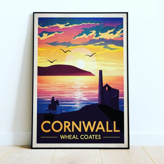
Excited to share the latest addition to my #etsy shop: Cornwall Travel Poster | Wheal Coates, St Just, Cornish Coast, Poster Wall Art | Wall Art, vintage Cornwall #poldark #rosspoldark #vintagebritain #britishmap #britishprints #ukmap https://etsy.me/2NiHsOg (at Saint Just, Cornwall, United Kingdom) https://www.instagram.com/p/CMYQtW2giQw/?igshid=1cu0d1i07fihe
2 notes
·
View notes
Photo

- Click Photo for Details - ★ Website ➔ www.InkistPrints.com ★ Etsy Store ➔ www.InkistPrints.etsy.com ★ Check Out Our Various Collection Pages ★ - Watercolor Art: http://etsy.me/2Lh618W - Watercolor Skyline: http://etsy.me/2UL5HTU - Watercolor Map: http://etsy.me/2EtNqpl - Disneyland: http://etsy.me/2BdChVI - Butcher’s Guide: http://etsy.me/2BfgtJd - Typography Map: http://etsy.me/2BlorAS - Typography: http://etsy.me/2PCSqZR - Customize Name: http://etsy.me/2QMFPIr - Nursery Decor: http://etsy.me/2Caxvdp - World Map: http://etsy.me/2BjE7od - USA Street Map: http://etsy.me/2EsIZeB - CANADA Street Map: http://etsy.me/2ryxmdz - EUROPE Street Map: http://etsy.me/2LekFh9 - FOREIGN Street Map: http://etsy.me/2RXXVo8
#UnitedKingdom#AnniversaryGifts#Poster#MapPoster#BarnsleyMap#EnglandArt#CustomGifts#EnglandPrint#UkMap#AnniversaryGift#BarnsleyPoster#UniqueGift#ChristmasGift#gifts#valentinesdaygifts#giftforher#giftidea#decoration#weddingifts#homedecor
4 notes
·
View notes
Text
What Are The Different Types Of Digital Maps? — Atlas Digital Maps
Digital Maps are nothing but virtual images of the natural world and the data collection on rails, roads, geological features and many more.
With the help of digital maps, one can easily find the distance from one place to another and the time required to cover that. Furthermore, making a digital map a software requires a tremendous amount of data, and then the data is compiled and converted into a virtual image which we see and use today.
What is the Use of Digital Maps in Today’s Time?
Digital maps are the virtual image of printed maps with a more accurate representation of a country/region or area. Moreover, with the help of digital maps, one can have a detailed look at the road arteries, specific locations and other points of interest.
Digital Maps are available in illustrator and vector format, are easily editable and can be used with flexibility, accuracy and styling for professional results. Furthermore, Digital Maps are ideal for Travelers, Graphic Designers, Businesses, Education, Advertising, Television, Film, and Government bodies.
What are the Main Types of Digital Maps in Atlas Digital Maps?
World Maps — All of our maps can be customised in terms of colour, typefaces, and styling. Our World Maps are available in a variety of sizes and projections. We display a substantial section of huge screenshots on the product pages since we are confident in our quality and want you to be sure it is the perfect map.
Regional Maps — Atlas Digital Maps provides a wide range of global, regional, and continent maps. Similarly, Regional Maps are available in both political and physical relief. Our maps are entirely layered, allowing you to quickly create maps by selecting the map elements you require. The Illustrator vector format guarantees excellent printed lines at every size.
British Isles/ UK Maps — Using ordnance survey data sourcing Atlas Digital Maps has a completely re-drawn mapping of the British Isles with unprecedented detail and accuracy. This unique product brings a whole new level of Illustrator based mapping to you, opening up new possibilities for design, print, apps and the web. Moreover, all the maps are 100% editable in colour, fonts and styling. We also offer a wide selection of UK regional map sub-categories for Scotland, North England, Central England, South East England, East England, South West England, and Wales maps with political and/or relief options.
Conclusion
In short, digital maps are the best option one can have in today’s time. With the help of digital maps, one can easily modify the maps as per their wish. Digital maps are very detailed, accurate and editable. As per their interest, one can mark and find new roads, railways, coastlines, boundaries, rivers & lakes, parks, etc.
Atlas Digital Maps are providers of innovative, eye-catching printed maps on canvas and pinboards and imaginative digital maps for graphic design. They are ideal for business, movies, TV, education, workplace and home decor.
0 notes
Photo
Hello small businesses! I’ve just listed this postcode map on my etsy for you to download, only for £1.50! I know digital downloads for maps like this can cost a lot, so I listed it for as cheap a price as I could! I wonder where your items have been 🤔 Check out the link in my bio for my products, and Dm me if you need anymore info! Make sure to like and share! ~ ~ ~ ~ ~ #newsmallbusiness #blackownedsmallbusiness #queersmallbusiness #lgbtfriendly #uksmallbusiness #handmadeuk #handmadewales #blackowneduk #teensmallbusinessowner #teenentrepreneur #handmadeaccesories #etsyselleruk #depopseller #etsyukseller #uniqueaccessories #postcode #postcodemap #digitaldownload #digitaldrawings #ukmap #ukartist #ukartists #pinkpinkpink #pinkmap #ordermap #postage #deliveryuk #etsydigital #etsydigitaldownloads #etsydigitalprints (at Uk) https://www.instagram.com/p/CL-Nv4GgCCO/?igshid=1bd5gltflcokw
#newsmallbusiness#blackownedsmallbusiness#queersmallbusiness#lgbtfriendly#uksmallbusiness#handmadeuk#handmadewales#blackowneduk#teensmallbusinessowner#teenentrepreneur#handmadeaccesories#etsyselleruk#depopseller#etsyukseller#uniqueaccessories#postcode#postcodemap#digitaldownload#digitaldrawings#ukmap#ukartist#ukartists#pinkpinkpink#pinkmap#ordermap#postage#deliveryuk#etsydigital#etsydigitaldownloads#etsydigitalprints
0 notes
Photo
Trying out something new. Pressed bluebells after using them to make ink. The paint used on this painting is the bluebell ink. Trying to reduce the waste but not compromise aesthetics. #artistinlondon #foragingforcolour #personaltouch #ukmap #newartwork #subtlechanges #londonartist #crouchend #crouchendopenstudios #purpletoblue #lisamarieprice #commissions #artforyourwalls #artcritic #artblogger #newideas (at Harringay) https://www.instagram.com/p/ByuWNPwniYw/?igshid=tthwetx4pvh4
#artistinlondon#foragingforcolour#personaltouch#ukmap#newartwork#subtlechanges#londonartist#crouchend#crouchendopenstudios#purpletoblue#lisamarieprice#commissions#artforyourwalls#artcritic#artblogger#newideas
0 notes
Photo

New postcard available on my Etsy shop soon!! Shop link in my bio. #ukmap #mapillustration #postcard #mappostcard #stationary #LivWan #mapart #mappa #mapillustrator #mapmaker #map #unitedkingdom #uk #illo #illustrator #artlicensing #design #etsy #editorial #editorialillustration #插畫 #插画 #插畫家
#illustrator#postcard#插画#artlicensing#editorial#mappa#mappostcard#illo#mapart#mapillustrator#unitedkingdom#design#etsy#mapmaker#stationary#插畫家#editorialillustration#uk#插畫#mapillustration#ukmap#livwan#map
1 note
·
View note
Link
Еще один критерий при выборе места - карты радона Великобритании. Там же на сайте можно купить прибор для измерения концентрации.
0 notes
Photo

Pictorial Map of English Literature #blue #printingprintmaking #yellow #office #minimalist #vintagebritain #britishmap #britishprints #ukmap https://etsy.me/2TW5W2Y (at United Kingdom) https://www.instagram.com/p/CRMFqP0jZsK/?utm_medium=tumblr
0 notes
Photo
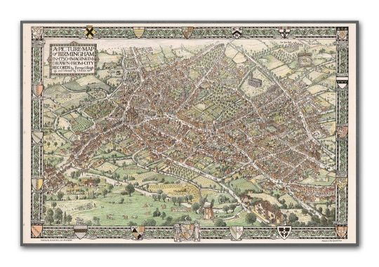
A Picture Map of Birmingham in 1730 | Vintage Birmingham Map | Imagined and designed by Bernard Sleigh | Wall Art | Old English Maps #bedroom #vintagebritain #britishmap #britishprints #ukmap #oldbritain #vintagemaps #birminghamuk #birminghammap https://etsy.me/3bIZ6mk https://www.instagram.com/p/CLuqH8Rp5Is/?igshid=1gcpdhbyqvzsb
#bedroom#vintagebritain#britishmap#britishprints#ukmap#oldbritain#vintagemaps#birminghamuk#birminghammap
0 notes
Photo

After a busy week going backwards and forwards to the Summer Exhibition last week I have finally managed to sit and do some more work. This piece is very nearly finished! I’m pleased with how it’s coming along. Swipe to see more detail. All artwork is for sale and commissions are welcome. #antiquemaps #handmadeink #foragingforcolour #personaltouch #ukmap #newartwork #subtlechanges #londonartist #crouchend #crouchendopenstudios #purpletoblue #lisamarieprice #commissions #artforyourwalls #artcritic #artblogger (at Harringay) https://www.instagram.com/p/Byo8jnjnhJS/?igshid=16052lhl9k25z
#antiquemaps#handmadeink#foragingforcolour#personaltouch#ukmap#newartwork#subtlechanges#londonartist#crouchend#crouchendopenstudios#purpletoblue#lisamarieprice#commissions#artforyourwalls#artcritic#artblogger
0 notes
Photo

Ok I’ve started on the UK map! I’m using an ink made from Aeonium Arborium otherwise known as ‘Schwarzkopf’. I wanted to try and show how the colour changes as it dries. It starts as a purple and dries as a beautiful blue. I just love how the inks I make gradually change. So many wonderful surprises each time. #antiquemaps #handmadeink #foragingforcolour #personaltouch #ukmap #newartwork #subtlechanges #londonartist #crouchend #crouchendopenstudios #purpletoblue (at Harringay) https://www.instagram.com/p/Bxj_Aj-HTgB/?igshid=1gy1ve3ady43s
#antiquemaps#handmadeink#foragingforcolour#personaltouch#ukmap#newartwork#subtlechanges#londonartist#crouchend#crouchendopenstudios#purpletoblue
0 notes
Photo

Old Maps Library is taking a trip back in time this week to some of the UK greatest cities.
Our first stop is in Bristol, 1750. A Survey of the City and Suburbs of Bristol Surveyed by the Land Surveyor at Charing Cross, published by John Rocque.
⠀⠀⠀⠀⠀⠀⠀⠀⠀
Bristol is a city steeped in history, best known for its iconic suspension bridge, thriving music scene, and flourishing street art culture.
Loved for its independent spirit and alternative vibe, Bristol boasts culture, creativity, and an impressive maritime legacy.
⠀⠀⠀⠀⠀⠀⠀⠀⠀
Nestled between Gloucestershire and Somerset it is just a one-hour-40-minute journey from London.
⠀⠀⠀⠀⠀⠀⠀⠀⠀
⠀⠀⠀⠀⠀⠀⠀⠀⠀
⏳ Old Maps Library specialises in the reprint of Vintage Maps and Illustrations between the 17th to 19th centuries.
⠀⠀⠀⠀⠀⠀⠀⠀⠀
🔎 Our prints are linen backed by hand, this technique gives it more durability and a beautiful vintage finish look.
⠀⠀⠀⠀⠀⠀⠀⠀⠀
⏳Linen backing is a technique that mapmakers used in the past as a solution to keep the maps stronger for long journeys and weather changes.
⠀⠀⠀⠀⠀⠀⠀⠀⠀
🔎Nowadays, this technique is an important conservation method for restoring and preserving vintage maps and posters.
⠀⠀⠀⠀⠀⠀⠀⠀⠀
⏳Our maps are folded and fitted into a marbled slipcase.
⠀⠀⠀⠀⠀⠀⠀⠀⠀
⏳ We have a beautiful collection of Old Maps and Vintage Illustrations on our website. Link on our bio. Are you also fascinated by old maps?
⠀⠀⠀⠀⠀⠀⠀⠀⠀
⏳
⠀⠀⠀⠀⠀⠀⠀⠀⠀
“Travel back to moments in time and discover the world heritage!”
⠀⠀⠀⠀⠀⠀⠀⠀⠀
#oldmap #vintagemap #ilovegreatbritain #bristolmap #citymap #ancientbritain #antiquemap #cartography #gallerywalldecor #worldmap #instamap #mapdecor #mapsarecool #mapsofinstagram #mapsandillustrations #homedecorationideas #maplove #lovemaps #mapshop #mapsoftheworld #oldword #antiquemapsandprints #framedmaps #map #mapart #wallframe #mapprints #mappe #ukmap #mapasantiguos
https://www.instagram.com/p/CFKI5r4J_Ly/?igshid=1bsvxijw1oeob
#oldmap#vintagemap#ilovegreatbritain#bristolmap#citymap#ancientbritain#antiquemap#cartography#gallerywalldecor#worldmap#instamap#mapdecor#mapsarecool#mapsofinstagram#mapsandillustrations#homedecorationideas#maplove#lovemaps#mapshop#mapsoftheworld#oldword#antiquemapsandprints#framedmaps#map#mapart#wallframe#mapprints#mappe#ukmap#mapasantiguos
0 notes