#passaconaway
Text
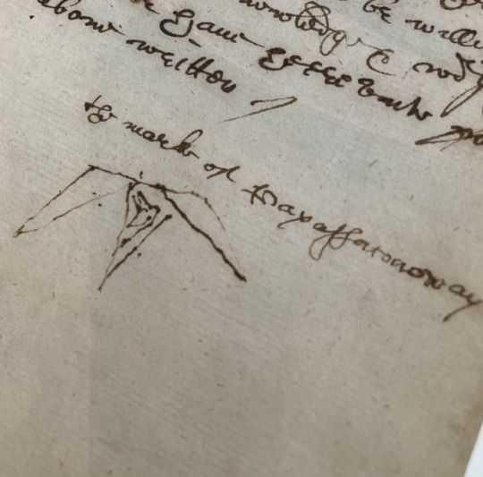
Passaconaway. The Mark of Payassaconoway.
Penacook. Their homelands along the Merrimack river, and at the places where the present-day boundaries of so-called “New Hampshire,” “Maine,” and “Massachusetts” exist. Sachem. Pauwau. Diplomat. This document, signed June 12, 1644, is interpreted as a peace agreement, signed by Passaconaway and Nahnanacomock, on behalf of the Pennacook, and the Massachusetts Bay Colony.
Passaconaway’s kin: a son, Wannalancet.
Seen at the Massachusetts State Archives.
#passaconaway#penacook#wanalancet#theirmarks#easternwoodlands#nativehistory#sachem#17thcentury#massachusetts#newhampshiire#maine#merrimackriver#massstatearchives#algonquian
1 note
·
View note
Photo

Eliot Porter, Maple and Birch Trunks and Oak Leaves, Passaconaway Road, New Hampshire, 1956, dye transfer print
108 notes
·
View notes


Text
Scale Beyond Peaks and Valleys: Summit Mount Galehead, Owls Head, Passaconaway, Moriah, Tom, and Jackson
Mount Galehead - Elevation: 4024 ft
Difficulty Level: As always, the difficulty level of each mountain is going to depend on the individual hiker, the trail chosen, trail conditions, etc. Once you select the mountain you want to hike based on these lists, it is crucial to complete your own due diligence regarding the weather, personal stamina, and hiking experience. Overall, Galehead is typically viewed as a moderately difficult and challenging hike.
Trail: There are many trails that one can take to summit Galehead, but the most direct and shortest route is via Gale River Trail. AllTrails link below:
Galehead Mountain via Gale River Trail, New Hampshire - 959 Reviews, Map | AllTrails
View from Galehead:

Parsons, G. (n.d.). The 4000-Footers of New Hampshire. New England Waterfalls. https://newenglandwaterfalls.com/4000footers-galehead.html
Owls Head - Elevation: 4025 ft
Difficulty Level: With Owls Head, we continue on with the theme of moderately difficult to challenging hikes. The majority of this rating stems from the distance of the hike, which if you are taking the all trails route, is over 17 miles long. This is the time to assess one’s abilities, because this route is not for the faint of heart. It is also important to note that the best views from this hike are from the side of the mountain, prior to the summit. The top is a wooded area, marked by a stone cairn.
Trail: The most popular trail is via Lincoln brook trail. All trails link below:
Owl’s Head Path via Lincoln Brook Trail, New Hampshire - 1,703 Reviews, Map | AllTrails
View from Owl's Head:

DesMarais, M. (2018, June 22). Hiking Owl’s Head Mountain | 4,025 feet | NH White Mountains. https://hikingandfishing.com/owls-head/
Mount Passaconaway - Elevation: 4043ft
Difficulty Level: With Mount Passaconaway we return to a less challenging distance, but still a moderately difficult route. If you are a more experienced hiker, I want to point out that many people also summit the lower in elevation Mount Whiteface (see previous post), in order to bag 2 of the 48 in one day. Consider this option!
Trail: There are two popular routes for Mount Passaconaway, the out and back trail that just summits Mount Passaconaway (via Diceys’s Mill Trail) and the loop that includes Mount Whiteface (Mount Whiteface and Passaconaway Loop). Both AllTrails link below:
Mount Passaconaway via Dicey's Mill Trail, New Hampshire - 636 Reviews, Map | AllTrails
Mount Whiteface and Passaconaway Loop, New Hampshire - 2,359 Reviews, Map | AllTrails
View from Passaconaway:

Mt. Passaconaway - NH Family Hikes. (n.d.). http://www.nhfamilyhikes.com/hikes.php?hike=Mt.%20Passaconaway&from=HBN-P
Mount Moriah - Elevation: 4,049ft
Difficulty Level: With Mount Moriah, we return to a hike more suited for beginners. The rating for this mountain falls between easy and moderate. As previous mentioned, the difficulty level can change drastically with trail conditions, specifically with Moriah, as a large portion of one of the trails has rock slabs. When wet or icy, it can become very dangerous.
Trail: The Carter Moriah trail is the most trafficked route. AllTrails link below:
Mount Moriah via Carter Moriah Trail, New Hampshire - 1,709 Reviews, Map | AllTrails
View from Moriah:

FranklinSites.com. (n.d.). Mt. Moriah - New Hampshire - January 24, 2010 Hike Trip Report - FranklinSites.com Hiking guide. https://www.franklinsites.com/hikephotos/NewHampshire/mtmoriah-2010-0124.php
Mount Tom - Elevation: 4,052 ft
Difficulty Level: Mount Tom, Like Moriah, is an easy to moderate 4,000 footer. Something that is really great about Mount Tom is that many trails allow for the perfect opportunity to not only bag 1 additional 4,000 footer, but 2! Both Mount Field and Mount Willey (which I will discuss in later blog posts) can be summited on a trail to the top of Mount Tom.
Trail: The most popular trail is the Willey Range Trail, but Mount Tom can also be reached via the Mount Tom, Avalon, and Field Loop. Both are great choices. AllTrails links below:
Mount Willey, Field, Avalon, Tom via Willey Range Trail, New Hampshire - 37 Reviews, Map | AllTrails
Mount Tom, Avalon, and Field Loop, New Hampshire - 1,264 Reviews, Map | AllTrails
View from Tom:

Dailey, C. (n.d.). Mount Tom / Mount Field / Mount Willey / Mount Waumbek ~ December 18th, 2011. https://whitemountainimages.blogspot.com/2011/12/mount-tom-mount-field-mount-willey.html
Mount Jackson - Elevation: 4052 ft
Difficulty Level: Mount Jackson is a personal favorite of mine, and I would recommend this hike to anyone seeking the easy-moderate range. The majority of the hike is not very challenging. The difficulty for this trail mainly stems from a rock scramble at the very end of the hike. The view of the Presidential range are beyond worth it though!
Trail: The best trail to access Mount Jackson is an out and back trail named “Mount Jackson Trail”. AllTrails link below:
Mount Jackson Trail, New Hampshire - 1,843 Reviews, Map | AllTrails
Here is a picture of me after I summited Jackson two years ago!

0 notes
Text
Two More Done
Pat’s constant companion. Working on her list of the 48 4000-footers in New Hampshire’s White Mountains, this tour to Whiteface (4020′) and Passaconaway (4043′) brought her two closer to completion with numbers 44 and 45 in the bag, as they say. The day started off a little slower due to ground fog, and mother nature toyed with the duo for a bit, but ultimately cooperated giving them pleasant…

View On WordPress
0 notes
Text
Hike: Passaconaway & Square Ledge
Hike: Passaconaway & Square Ledge on a beautiful October weekend. #mainewanderlust #optoutside #foliage

Lindsay and I hiked our first New Hampshire 4000 Footer together on a beautiful October weekend. After hitting Mount Passaconaway and its viewpoint, we headed out to Square Ledge to check out the retired 52 with a View.

ROUTE
Parked at Ferncroft Trailhead parking on Ferncroft Road in Albany, NH
Hiked up Old Mast Road to 4-Way Intersection
Left on Walden Trail to summit of Mount Passaconaway
L…
View On WordPress
0 notes
Text
Passaconaway Road (NH)
6 October 2021

The ride this morning was a simple out-and-back, but on different sides of the Swift River. The trip up the river was on the old Passaconaway Road on the north bank. The trip back down was on the newer Kancamagus Highway (NH 112) along the south bank. The climb was a bit more than 400’ over 7’ish miles, so not steep. The outbound leg was a rolling climb, but the steeper sections were short and rarely pushed more than 5%. The return was fast and smooth - the road descends at a very even 1-2%. It levels out when it reaches NH 16 in Conway - and that’s also where the big traffic backup began from the downtown construction. I was able to make it through town much faster than the cars.

The old road was quiet. I saw almost no cars once the houses ran out on the lower section, though it was a bit of a surprise to reach the upper bridge around 8:00 AM and find it crawling with tourists whose tour bus was parked on the other side! The new road was a little busier, but it’s wide (the shoulder varies), and cars had no problem giving me a wide berth.


There were two covered bridges in the first quarter mile, neither of which I actually had to cross. One crossed the Saco River; the other crossed the Swift River. And then there was the Albany Bridge at the top of the ride where the Passaconaway Road crosses back over the Swift before joining the newer road.


A little over two years ago (Biketrip2019) I pedaled out of Conway by exactly this same route on my way to Seattle. Day 2 of 54! That morning, I was overwhelmed by both the excitement and the fears that go with starting a big adventure. Today I was caught up in the emotions associated with those memories. We’ve crossed paths with that bike trip a number of times on this road trip and every time it stirs some pretty powerful feelings. Two years ago, I turned right after crossing the Albany Bridge and continued climbing west over the Kancamagus. Today, I turned left, coasted back into town, and put the bike back in the car!


2 notes
·
View notes
Text
17 Superstars We’d Love to Recruit for Our Chelmsford MA Team
Oops! It looks like our use Investigation algorithms feel that you might be a robot. Accessing the redfin.com in an automatic fashion is really a violation of the Redfin's terms of use.
Microsoft and DuckDuckGo have partnered to supply a lookup Option that provides pertinent ads to you personally when shielding your privateness. For those who click on a Microsoft-furnished advertisement, you will be redirected to the advertiser’s landing web site via Microsoft Advertising and marketing’s System.
GIS Mapping This link will present details personal Houses and a variety of layered maps which include; topography, open up House, land conservation, zoning and districts, historic & cultural methods, drinking water and wetland methods
This is actually the Model of our Internet site resolved to speakers of English in The usa. For anyone who is a resident of One more nation or area, make sure you pick the appropriate Model of Tripadvisor for your place or location during the drop-down menu. much more
What is going on on with this Group in Chelmsford, regarding race? are they consuming the interesting-help? Are they attempting to disgrace the Citizens of Chelmsford into imagining They're racist? If they're endeavoring to change/relive the past, it might't b performed.
youtube
Planning to undertake a furry Good friend? Have a look at this week's listing of Animals waiting at shelters in and all-around Chelmsford.
The lender initiated foreclosure proceedings on these Homes as the proprietor(s) were being in default on their personal loan obligations. Pre-foreclosures also consist of Attributes for which a foreclosure auction is scheduled.
Would you at present satisfy the condition’s skills for getting the COVID-19 vaccine? If that's the case, have you been capable of Obtain your shot, and what has your practical experience been like?
I noticed that after you attribute a profile over a Applicant to the Board of Pick Man or woman, in Chelmsford, the one query they fail to reply/comment on is the failure of your BoS for that past 2 several years.
Homeowners occupy all-around ninety% in the Attributes in Chelmsford though the rest are rented. Within this town, all over two thirds of dwellings are single detached houses, even though huge apartment properties also are current from the housing inventory.

"It will probably be a slow and gradual method to reopen safely and securely," Director of Human Providers Debi Siriani mentioned in an announcement. Among the first things which has introduced again precise people towards the making —in incredibly restricted figures and with masks —are tax appointments, she reported.
YP - The actual Yellow PagesSM - allows you find the right area corporations to meet your precise requires. Search engine results are sorted by a combination of elements to provide you with a list of selections in response to your search conditions. These factors are just like People you would possibly use to select which organization to select from a neighborhood Yellow Pages Listing, such as proximity to where you are looking, know-how in the precise providers or products you would like, and detailed small business info to assist evaluate a business's suitability for you.
Successive Pennacook leaders Passaconaway and Wonalancet strove to placate and sustain peace with the eu settler-colonizers who founded Chelmsford within just their territory.[1] In spite of this, the settlers became progressively violent to the Pennacook, typically forcing them to flee north. On 1 these kinds of event in 1675, Chelmsford settlers burned alive the handful of Pennacook who had been much too Ill or outdated to flee north with their kin.[one] The Pennacook finally joined their relations in Odanak; right now their descendants, who will be members in the Abenaki Initial Nation, continue on to perspective Chelmsford as section of their country's ancestral and unceded homeland.[five][six]
Lee and her spouse were being entire world tourists, having fun with the numerous histories and cultures of 38 nations and much of America.
From Business: 110 Grill is exactly where modern day eating and progressive Delicacies fulfill. Listed here we have been passionate about pure flavor, high quality ingredients, along with the cultivation of the…
1 note
·
View note
Photo

Trunks of maple and birch with oak leaves. Passaconaway Road, New Hampshire, 1956.
Eliot Porter, Intimate Landscapes, p. 1979
5 notes
·
View notes
Text

The mark of Nahnanacomock.
Penacook. Their homelands along the Merrimack river, and at the places where the present-day boundaries of so-called “New Hampshire,” “Maine,” and “Massachusetts” exist. This document, signed June 12, 1644, is interpreted as a peace agreement, signed by Passaconaway and Nahnanacomock on behalf of the Pennacook, and the Massachusetts Bay Colony.
Nahnanacomock’s kin: one source suggests Nahnanacomock is the son of Passaconaway.
Seen at the Massachusetts State Archives.
#nahnanacomock#pennacook#theirmarks#easternwoodlands#nativehistory#sachem#17thcentury#massachusetts#newhampshiire#maine#merrimackriver#massstatearchives#algonquian
2 notes
·
View notes
Photo

Where the mountains meet the lake #whiteface #passaconaway & #chocorua as seen from #lakewinnipesaukee. (at Lake Winnipesaukee, New Hampshire)
0 notes
Photo

“Passaconaway” (1915)
by Allen Tucker (1866 - 1939)
6 notes
·
View notes
Text
Explore Mount Tecumseh, Mount Isolation, Mount Waumbek, and Mount Whiteface: Lower in elevation, but high in enjoyment!
Now that I have covered an introduction of the NH48 and key hiker recommendations, I can now begin the next part of our series, which is detailing each of the peaks. I will start with the lowest elevation, and work up to the highest.
Mount Tecumseh - Elevation: 4,003ft
Difficulty Level: How easy or hard a hike is depends on a multitude of factors such as stamina of the individual hiker, trail conditions, trail length, etc. That being said, Mount Tecumseh is generally considered one of the easier 4,000 footers, and is a good starting point for those just starting to conquer the NH48.
Trail: A great resource to reference when considering trail options is the “AllTrails” website or mobile app. It includes reviews of trail conditions, images, and hike descriptions. One of the most popular trail options to summit this peak is via Waterville Valley Ski Resort. AllTrails link below:
https://www.alltrails.com/trail/us/new-hampshire/mount-tecumseh-trail-via-waterville-trailhead
View from Mount Tecumseh:

Hesselbach, B. (2016, August 21). Hiking Trails. Pinterest. https://www.pinterest.com/pin/568931365410416552/
Mount Isolation - Elevation: 4,004ft
Difficulty Level: Do NOT underestimate this mountain! It is considered a challenging hike, with rock scrambles, and steep sections as well. If you are newer to hiking, I recommend putting an asterisk next to this one, and revisiting when you have at least 5 4,000 footers under your belt.
Trail: The most popular trail for this hike is the Glen Bolder Trail. AllTrails link below:
Mount Isolation via Glen Boulder Trail, New Hampshire - 717 Reviews, Map | AllTrails
View from Mount Isolation:

Nomad, N. T. (2023, October 4). Mount Isolation hike via Glen Boulder Trail and Rocky Branch Trail — Nichole the Nomad. Nichole the Nomad. https://nicholethenomad.com/hiking-blog/mount-isolation
Mount Waumbek - Elevation: 4,006ft
Difficulty Level: Mount Waumbek is considered another one of the easier 4,000 footers. Keep in mind that in order to hike the shortest trail, you will cross over another mountain, called Mount Starr King.
Trail: Mount Starr King Trail is the most common trail, which is an out and back path. AllTrails link Below:
Mount Waumbek and Mount Starr King via Starr King and Kilkenny Ridge Trail, New Hampshire - 4,359 Reviews, Map | AllTrails
View from Mount Waumbek:

Hesselbach, B. (2015, September 25). Hiking Trails. Pinterest. https://www.pinterest.com/pin/568931365405711942/
Mount Whiteface - Elevation: 4,019 ft
Difficulty Level: While Mount Whiteface, is one of the easier 4,000 footers, something important to note about this peak is that there are a couple of popular trails, which can vary in difficulty.
Trail: Two of the most popular trails are linked below
Via Blueberry ledge Trail: Mount Whiteface via Blueberry Ledge Trail, New Hampshire - 840 Reviews, Map | AllTrails
Via Passaconaway Loop: Mount Whiteface and Passaconaway Loop, New Hampshire - 2,361 Reviews, Map | AllTrails
View from Mount Whiteface:

Mount Whiteface Mountain information. (n.d.). https://www.mountain-forecast.com/peaks/Mount-Whiteface
0 notes
Photo


Sunday I hiked Passaconaway and Whiteface in the Whites. I slept at the trailhead Saturday night, and I am quite a fan of the mattress I got for the back of my car! Anyway, the hike was frustrating but good. Snow-covered branches reaching across the trail hit my face and my pack, dropping snow all over me and into the outer pockets of my pack. I took the trail less traveled to the top of Passaconaway and postholed every few steps. I brought my snowshoes, but it wasn't bad enough to justify using them. I find my snowshoes so cumbersome that I'd rather randomly posthole. On the way up Whiteface a branch caught one of my snowshoes and ripped both of them out of my pack. I screamed and cursed the AMC for not doing basic trail maintenance. The few on top of Whiteface made it all worth it, especially since the sun was out and warming the summit. I made good time down the mountain and took advantage of a flat, warm and dry rock on the side of the trail and soaked up some rays.
10 notes
·
View notes
Text
Walkin' and Rockin'
Walkin’ and Rockin’
We had a few things going on this past weekend while a number of guides also happened to be unavailable for one reason or another. Thus, Redline Guide Pat Ferland was out there guiding on both days (even Mike Cherim was guiding, but that’s another story — one we’ll get to). The first trip was a returning guest looking for a companion on the Whiteface-Passaconaway standard loop using Blueberry…

View On WordPress
0 notes
Video
Some practice stuff with the finger picks on my ole strat #passaconaway @fender #strat #guitar #stratocaster #fenderguitars #blues #bluesguitar #fingerpicks #fingerpicking https://www.instagram.com/p/B16gdG6H2NL/?igshid=1h4n59ylfytlr
0 notes
Last Seen Blogs

torqbox
Untitled

nourstattoo
NOURS TATTOO


dxrren9-blog
Dxrren9

champagnechallenge
Champagne Challenge