#pentax_dfa28105
Text

New Year's Daybreak at Shirahama
Location: Shirahama Beach, Shimoda, Shizuoka, Japan
Timestamp: 06:56 on January 3, 2024
Pentax K-1 II + DFA 28-105mm F3.5-5.6
31 mm ISO 800 for 1/640 sec. at ƒ8.0
My first visit to Shirahama Beach on the western coast of the Izu Peninsula located 175 km (107 mi) southwest of Tokyo was in the late 1980s. Barbecues on the beach, following a day of swimming or surfing, were popular back then. Unfortunately, as time passed, some beachgoers neglected to clean up after themselves, leading to the prohibition of beachside barbecues by the late 90s.
In response, local merchants and entrepreneurs initiated delivery services for food, drinks, beach umbrellas, and inflatable floats. They also patrolled the beach for litterbugs. Overall, this change significantly improved the beach's cleanliness for almost two decades now.
Most of my beach visits have been in summer, with a few during winter. However, this year marked my first New Year's holiday visit. After tending to the family graveyard, I took the scenic route home, making stops at Shirahama Beach and Shirahama Shrine for the traditional New Year's shrine visit (初詣・hatsumode) and to witness the first sunrise of the year (初日の出・hatsuhinode). Despite the usual recommendation to observe hatsuhinode on January 1st, I waited until January 3rd to avoid the beach crowds and heavy traffic back to Tokyo.
Setting up my camera and tripod for this shot, I paused to reflect. The crashing waves, gentle flow of seawater around beach stones, and the warm glow of the rising sun created a serene atmosphere. Amidst the fresh ocean breeze, contemplating my fortunes over the past 40 years, I found myself captivated by nature's beauty and felt grateful for the chance to appreciate this moment.
Google Maps links to Shirahama Beach, Shirahama Shrine, and links to sources of additional reading (Japanese and English) can be found in the most recent pix4japan blog post: https://www.pix4japan.com/blog/20240103-shirahama
#海の風景写真#静岡#下田#日の出#白浜海岸#pix4japan#pentax_dfa28105#pentaxk1mkii#seascape photography#Japan#Shirahama Beach
60 notes
·
View notes
Photo
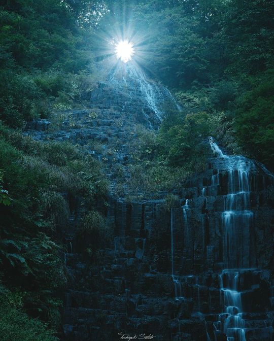
📷 Water falling from the sun☀️ #peaceforukraine #waterfall #landscapephotography #naturephotography #artofvisual #ig_landscape #yourshotphotographer #amazing_shots #photographersoninstagram #landscapelovers #naturelovers #nature_good #pictas #pictasart #pictastravel #shootpentax #teamPentax #pentaxk1 #pentax_dfa28105 #amazing_shots #akita #japan #日本 (Yurihonjō) https://www.instagram.com/p/ChcrdR6pU3-/?igshid=NGJjMDIxMWI=
#peaceforukraine#waterfall#landscapephotography#naturephotography#artofvisual#ig_landscape#yourshotphotographer#amazing_shots#photographersoninstagram#landscapelovers#naturelovers#nature_good#pictas#pictasart#pictastravel#shootpentax#teampentax#pentaxk1#pentax_dfa28105#akita#japan#日本
0 notes
Text
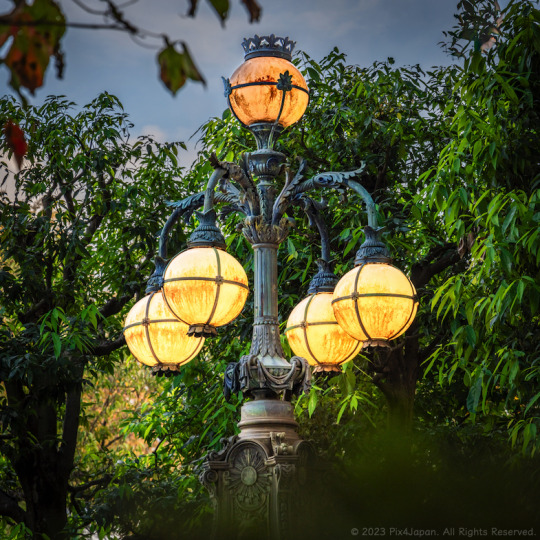
Restored Tokyo Imperial Palace Bridge Lamp from 1888
Location: Edo-Tokyo Open Air Architectural Museum, Tokyo
Timestamp: 16:12 on October 25, 2023
Pentax K-1 II + DFA 28-105mm F3.5-5.6
105 mm ISO 200 for 1/125 sec. at ƒ/7.1
Captured in this image is an ornamental electric light, a stunning example of Baroque style, originally positioned at the main gate of the Imperial Palace in Chiyoda Ward, Tokyo, from the late 1880s to the mid-1890s.
In my most recent blog post (https://www.pix4japan.com/blog/20231025-bridge-lamp), I explore the history of the German manufacturer of the lamp and their influence on Japan's modernization (3-minute read).
#都市景観#皇居正門石橋飾電燈#江戸東京たてもの園#��京#pix4japan#pentax_dfa28105#pentaxk1mkii#urbanscape photography#Tokyo#Japan#Edo-Tokyo Open Air Architectural Museum
81 notes
·
View notes
Text

Rest and Rejuvenation: Unveiling the Goronekan Respite in Yamanashi
Location: Fujikawaguchiko, Yamanashi Pref., Japan
Timestamp: 11:55・2024/03/20
Pentax K-1 II + DFA 28-105mm F3.5-5.6 + CP
31 mm ISO 100 for 1/320 sec. at ƒ/8
The Goronekan is a meticulously restored thatched-roof structure within the Saiko Iyashi-no-Sato Nenba open-air museum, in Yamanashi Prefecture, Japan, offers visitors a serene retreat. Additionally, it serves as an intimate venue for small concerts featuring traditional Japanese musical instruments, adding a cultural dimension to its charm.
The name itself, Goronekan, translates to "Falling asleep in one's clothes to take a nap" combined with "public building." Essentially, Goronekan serves as a respite for weary visitors, offering a place to rest and rejuvenate on traditional tatami mats or wooden floors after exploring the village's many attractions.
Perched at the highest point of the open-air museum, Goronekan treats visitors to a majestic vista of Mount Fuji, framed by the quaint thatched roofs of neighboring buildings, provided the weather cooperates.
For a deeper delve into the other activities available at Goronekan, including Google Maps links, sources, and references for further reading, check out the full write-up—a short 1-minute read (https://www.pix4japan.com/blog/20240320-goronekan).
#風景写真#山梨県#西湖いやしの里根場#ごろ寝館#pix4japan#pentax_dfa28105#pentaxk1mkii#landscape photography#Japan#Yamanashi Prefecture#Saiko Iyashi-no-Sato Nenba#Goronekan
17 notes
·
View notes
Text
From Fodder to Roofing: Pampas Grass and Thatched Roofs in Modern-Day Japan
Location: Lake Tanuki, Shizuoka, Japan
Timestamp: 08:02・2024/02/28
Pentax K-1 II + DFA 28-105mm F3.5-5.6 + CP
48 mm ISO 100 for 1/100 sec. at ƒ/11
For over five centuries, pampas grass was ingrained in the daily lives of the Japanese people. It served not only as fodder for cattle and horses but also as a key component for thatched roofs.
Following World War II, the surge in economic growth had a profound impact on the landscape of traditional houses, which underwent a transformation into Western-inspired designs along with a shift in roofing materials. Additionally, the utilization of natural roofing materials became restricted, primarily confined to heritage sites as dictated by revised building codes.
While thatched roofs are commonly associated with farmhouses and mountain dwellings today, certain structures like buildings and gates at shrines and temples continue to embrace this traditional roofing material.
From its historical significance in thatched roofs to the contemporary challenges faced by skilled thatchers, discover the journey of pampas grass, contributing to nationwide repairs on cultural landmarks, including national treasures and significant cultural properties at the full write-up, which includes Google Maps links and references for further reading (https://www.pix4japan.com/blog/20240228-pampas).
#風景写真#富士山#田貫湖#薄#ススキ#pix4japan#pentax_dfa28105#pentaxk1mkii#landscape photography#Japan#Mt. Fuji#Lake Tanuki#pampas grass
22 notes
·
View notes
Text
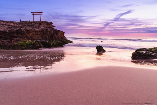
Torii Gate on Reef Facing the Rising Sun
Location: Shirahama, Shimoda, Shizuoka, Japan
Timestamp: 06:30 on January 3, 2024
Pentax K-1 II + DFA 28-105mm F3.5-5.6
28 mm ISO 100 for 0.5 sec. at ƒ/8.0
Located within a 3-hour drive of Tokyo, Shirahama Beach is a popular destination for beachgoers and surfers during the summer. While surfers are still present during the colder months, the beach is mostly empty, providing an opportunity to experience long stretches of sand free of human footprints.
At the northern end of the beach lies Daimyojin-Iwa (大明神岩), roughly translated to “rock of deity with extraordinary spiritual powers.” Atop Daimyoji Iwa stands a red torii gate facing the sea. The torii belongs to Ikona-hime-no-Mikotojinja Shrine, commonly known as Shirahama Shrine, the oldest Shinto shrine on the Izu Peninsula, and is only a 2-minute walk from the shoreline.
During midday, you can enjoy the lovely white sands and deep turquoise sea that stand in stark contrast with the red torii gate. If you visit early in the morning, however, you can experience beautiful skies and a sandy shore blanketed in a soft coral pink hue.
Google Maps links to this destination, and links to sources of additional reading can be found in the most recent pix4japan blog post: https://www.pix4japan.com/blog/20240103-shirahama
#海の風景写真#白浜海岸#大明神岩#白濱神社#pix4japan#pentax_dfa28105#pentaxk1mkii#seascape photography#Japan#Izu#Shimoda#Shirahama Beach
27 notes
·
View notes
Text


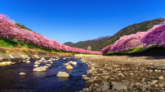
Chasing Early Bloom: Kawazu-Zakura Festival 2024
Location: Kawazu River, Kawazu, Shizuoka, Japan
Timestamps: 08:18, 08:20, and 08:40 on February 14, 2024
Pentax K-1 II + DFA 28-105mm F3.5-5.6 + CP
① 68 mm ISO 100 for 1/100 sec. at ƒ/10
② 28 mm ISO 100 for 1/160 sec. at ƒ/9.0
③ 31 mm ISO 100 for 1/200 sec. at ƒ/7.1
My first visit to the Kawazu-Zakura Cherry Blossom Festival was on March 2, 2022, two days after the festival had officially ended. This year, I timed my visit to the festival to coincide with a photo shoot at Imaihama Beach, which is just a 10-minute from the Kawazu River where the cherry trees are situated.
While the annual cherry blossom festival officially extends until February 29th, locals I spoke with anticipated tourists continuing to visit as late as the first week of March.
Here are three of my favorite shots along the Kawazu River:
① The first shot was taken on the eastern end of Kinomiya Bridge (来宮橋), crossing Kawazu River, about an 18-minute walk from Kawazu Station. Looking north, a glimpse of the vermilion-colored Hosen Bridge (豊泉橋) adds to the scenic view.
② The second shot was taken a few meters north of Kinomiya Bridge on the eastern riverbank. This spot provided ample foliage and shadows to almost hide the buildings and man-made structures behind the cherry trees, creating a nice contrast with the dark Kawazu-zakura pinks against the evergreen hills in the background.
③ The third shot was captured from the middle of the riverbed, right across from the tourist information booth on the northern riverbank, a 26-minute walk from Kawazu Station.
For those planning to visit the festival by train, I have included a link to Donny Kimball’s “Come to Kawazu | Enjoy Japan’s Cherry Blossoms in February” blog post, where he recommends the best way to reach the festival by train.
If, like me, you travel with a border collie, driving is the only option. From central Tokyo, it's a 2-hour 30-minute to 3-hour drive (depending on traffic). Kawazu Town is only 185 km southwest of central Tokyo, so even if you avoid the expressways, you can still reach this destination in less than 4 hours if you leave early enough in the morning.
For photographers attending this festival, try to schedule your visit on a weekday early in the morning. With very few crowds, it becomes easy to set up a tripod to bracket your shots, take long exposures of the river, or capture some panoramas.
If you have time, I'd recommend taking a leisurely drive home via Route 135, running the entire length of the eastern coastline of the Izu Peninsula. Roll down the windows, let the sea breeze enter the cabin, and be sure to stop at any of the numerous roadside rest stops that often offer spectacular views of the coastline.
I've gone into greater details on how to access the festival by car and have gathered with great info, downloadable PDF maps, and have Google Maps links to 3 of the larger parking lots. The write-up is less than a 3-minute read (https://www.pix4japan.com/blog/20240214-kawazu-zakura).
#風景写真#伊豆半島#河津町#河津桜#pix4japan#pentax_dfa28105#pentaxk1mkii#landscape photography#Japan#Shizuoka Prefecture#Kawazu Town#Kawazu cherry blossoms
22 notes
·
View notes
Photo

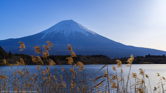
Mt. Fuji Towering Over Coastal Concrete Barrier
Location: Miho Peninsula, Shizuoka Prefecture, Japan
Timestamp: 15:19 April 5, 2023
Typically, when people think of Mt. Fuji, they imagine a breathtaking snow-capped mountain set as a backdrop of natural beauty. This may include freshwater lakes, rows of flowerbeds, expansive beaches, or high-elevation shots of city lights. However, for me, the scene has a distinct street-photography vibe.
As I gaze upon the majestic mountain, I am struck by the juxtaposition of man-made structures that have contributed to the destruction of the once white sands of this particular beach. It's a stark reminder of the impact humans have on the environment, and how our actions can last for centuries to come.
Despite this destruction, Mt. Fuji remains one of Japan's most important symbols of natural beauty and is revered by adherents of the native belief system of Shintoism, where the mountain is considered one of the more important gods.
The scene before me is a testament to the complexity of human-nature interactions and the importance of respecting and preserving our natural surroundings. It serves as a reminder that we must strive to strike a balance between our modern way of life and our responsibility to protect the planet for future generations.
Pentax K-1 II + DFA 28-105mm F3.5-5.6
63 mm ISO 100 for 1/200 sec. at ƒ/11
#海景写真#静岡県#駿河湾#富士山#三保松原#テトラポッド#4脚ブロック#pix4japan#pentax_dfa28105#pentaxk1mkii#seascape photography#Japan#tetrapod#Shizuoka#concrete#Mt. Fuji
146 notes
·
View notes
Text
Momiji Autumnal Leaves & Mt. Fuji
Location: Koyodai Observatory Terrace, Narusawa Village, Yamanashi Prefecture, Japan
Timestamp: 15:58 on November 15, 2023
Pentax K-1 II + DFA 28-105mm F3.5-5.6
28 mm ISO 100 for 1/30 sec. at ƒ/11
Using the Pentax “Pixel Shift Resolution II” feature, I captured four full-resolution photos of this scene from the 2nd floor landing at the Koyodai-Tenbodai Rest House. These shots, processed in-camera, synthesize the 4 shots into a single, super-high-resolution composite image. This not only enhances the resolving power but also eliminates false color, reduces high-sensitivity noise, and significantly improves overall image quality.
Positioning your tripod in the left corner of the landing on the 2nd flat of stairs provides an unobtrusive vantage point for capturing the breathtaking scene. The Japanese maple tree visible from the second floor of the Koyodai Observatory Terrace adds a captivating foreground element, complementing the vibrant autumn colors in the lower mid-ground of the scene.
For more in-depth information on the history of the Koyodai-Tenbodai Rest House, optimal parking locations, and nearby bus stops, check out my blog post. I hope to guide you through planning a visit to this off-the-beaten-path site, offering a serene experience away from the typical tourist crowds:
https://www.pix4japan.com/blog/20231115-koyodai
#風景写真#紅葉#山梨県#富士山#紅葉展望台レストハウス#pix4japan#pentax_dfa28105#pentaxk1mkii#landscape photography#Japan#Yamanashi Prefecture#Mt. Fuji#Koyodai Terrace
34 notes
·
View notes
Text
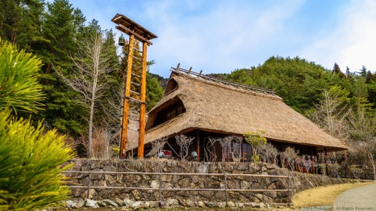
From Fire Lookout to Costume Haven: Hinomiya Building in Saiko Iyashi-no-Sato Nenba
Location: Fujikawaguchiko, Yamanashi Pref., Japan
Timestamp: 12:02・2024/03/20
Pentax K-1 II + DFA 28-105mm F3.5-5.6 + CP
28 mm ISO 100 for 1/40 sec. at ƒ/11
The Hinomiya building (火の見屋) is a restored thatched-roof house currently being used as a costume rental shop within the Saiko Iyashi-no-Sato Nenba open-air museum in Yamanashi Prefecture, Japan. Visitors can rent costumes tailored as kimonos, sets of samurai armor, ninja costumes, and more to wear and pose for photos around the museum.
The name 'Hinomi' (火の見) translates to “fire lookout,” which explains the presence of a bell at the top of the tower situated in the front yard of this old restored house.
In pre-modern Japan, many villages and cities were constructed from flammable materials such as wood, bamboo, straw, and paper. Due to the proximity of structures, fires could easily spread. In response, the Shogunate mandated the construction of watch towers in 1723. For further insight into this historical context, consider reading “Fire-Fighting and Disaster Prevention in Edo” published by the Journal of Japanese Trade & Industry in November/December 2000, authored by historian Sumiyoshi Yamamoto.
Check out the full write-up (a short 1-minute read) for Google Maps links, and references for further reading (https://www.pix4japan.com/blog/20240320-hinomiya).
#風景写真#山梨県#西湖いやしの里根場#火の見屋#pix4japan#pentax_dfa28105#pentaxk1mkii#landscape photography#japan#yokohama#Saiko Iyashi-no-Sato Nenba#Hinomiya
13 notes
·
View notes
Text
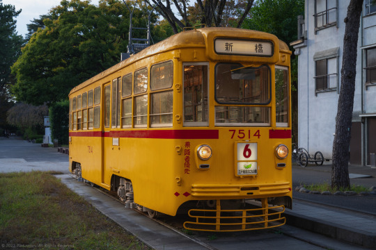
Tokyo Streetcar from 1962
Location: Edo-Tokyo Open Air Architectural Museum, Tokyo
Timestamp: 15:58 on October 25, 2023
Pentax K-1 II + DFA 28-105mm F3.5-5.6
53 mm ISO 400 for 1/125 sec. at ƒ/7.1
The 7500 series streetcar was once a vital part of Tokyo’s tram lines, traversing three routes connecting Shibuya, Shinbashi, Hamacho-Nakanohashi, and Suda-cho Stations. Placed in the Edo-Tokyo Open Air Architectural Museum, this restored streetcar is a captivating piece of Tokyo's past for all generations to enjoy.
In my most recent blog post (https://www.pix4japan.com/blog/20231025-streetcar), I explore the history of the 7500 Series streetcar, a quick look at streetcar usage during the Showa Era in Tokyo, and reminisce about old trains from the early 1980s. I also provide links to Google Maps and to source materials (7-minute read).
#都市景観#都電7500形#江戸東京たてもの園#東京#pix4japan#pentax_dfa28105#pentaxk1mkii#urbanscape photography#streetcar#Japan#Tokyo#Edo-Tokyo Open Air Architectural Museum
30 notes
·
View notes
Link
Sacred Ancient Trees at Shinto Shrine
Location: Fujikawaguchiko, Yamanashi Pref., Japan
Timestamp: 15:11・2024/03/20
Pentax K-1 II + DFA 28-105mm F3.5-5.6 + CP
28 mm ISO 6400 for 1/125 sec. at ƒ/8
Situated approximately 20 meters (65 ft) to the east of the Kawaguchi Asama-Jinja Shrine in Yamanashi Prefecture, Japan, stand two ancient trees known as the Futahashira-Sugi (両柱杉) cedars. Among the renowned seven cedar trees at the shrine, the cedar on the right reaches a towering height of approximately 47.5 meters (156 ft), making it the tallest.
The origin story of these two trees is fused with the belief that the roots of the right tree gradually grew and intertwined with those of the smaller tree on the left, symbolizing a physical and metaphorical union. This union has transformed them into revered entities, worshiped for their association with successful matchmaking, fertility, and safe childbirth. Their significance is further emphasized by the shimenawa rope, signifying their status as revered landmarks.
Check out the full write-up, a concise 1-minute read, which includes a glossary, Google Maps links, and links to source materials for further reading (https://www.pix4japan.com/blog/20240320-trees).
#風景写真#山梨県#両柱杉#河口淺間神社#pix4japan#pentax_dfa28105#pentaxk1mkii#landscape photography#Japan#Yamanashi Prefecture#Kawaguchi Asama-Jinja Shrine
15 notes
·
View notes
Text

Steam Locomotive and Passenger Car
Location: Koganei Park, Koganei, Tokyo
Timestamp: 12:33 on October 25, 2023
I came across this static display of an old steam locomotive and passenger car along my way to visit the Edo-Tokyo Open Air Architectural Museum (江戸東京たてもの園).
After some digging around on the web, I learned that the C57 steam locomotive and Suhafu-32 passenger car have been on display at Koganei Park since 1975, fulfilling the wishes of local residents.
I also learned that between 1937 and 1947, over two hundred Class C57 steam locomotives were built and put into service until 1975. Presently, thirty-two C57 locomotives are on display at various locations across Japan. Additionally, two locomotives have been restored and are now operational for special leisure lines and events.
The Suhafu-32 (スハフ32) passenger cars were utilized nationwide from the late 1930s through the 1950s. The designation is as follows:
ス/su=steel car weighing between 37.5 and 42.5 tons
ハ/ha=third class passenger cabin
フ/fu=passenger car equipped with a conductor cabin
Visit the Pix4Japan blog for Google Maps links and helpful references for further reading (https://www.pix4japan.com/blog/20231025-edo-bldg-museum). I've curated all the necessary details on accessing this location and have provided source references.
Pentax K-1 II + DFA 28-105mm F3.5-5.6
73 mm ISO 100 for 1/15 sec. at ƒ/11
#東京#小金井市#小金井公園#国鉄スハ32系客車#C57形蒸気機関車#小金井公園SL展示場#pix4japan#pentax_dfa28105#pentaxk1mkii#urbanscape photography#Japan#Tokyo#Koganei#Koganei Park#passenger car#steam locomotive#SL
23 notes
·
View notes
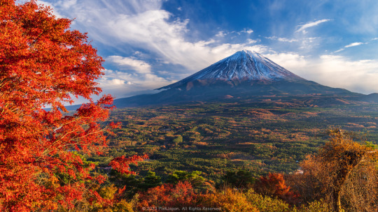
Text

A Scenic Drive through Izu via the Izu Skyline
Location: Izu Skyline, Shizuoka, Japan
Timestamps: 15:05 on February 14, 2024
Pentax K-1 II + DFA 28-105mm F3.5-5.6 + CP
105 mm ISO 100 for 1/160 sec. at ƒ/8.0
Leaving the lovely Kawazu Cherry Blossom Festival in Kawazu, Shizuoka Prefecture, my journey continued northward on Route 135, a picturesque two-lane highway that closely hugs the eastern coastline of the Izu Peninsula.
From Route 135, heading west on Prefectural Road 80 for a brief 10-minute drive (6 km) to reach the breathtaking Izu Skyline, a well-known toll road that extends over 40 km along the eastern Izu ridgeline and connects Atami Pass to the Amagi Plateau.
Toll charges vary based on the chosen interchange, ranging from 220 yen to 1,000 yen. It's important to note that the Izu Skyline only accepts cash payments; ETC or credit card transactions are not available.
The Izu Skyline boasts multiple rest stops where drivers can safely pull over and take a break and stretch their legs, give their dogs some exercise, and capture stunning photos of the windswept landscape and panoramic views of Mt. Fuji.
This shot shows a hint of the city of Susono, nestled near the southwestern base of Mt. Fuji. Despite the overcast skies, the slow-moving clouds delicately hovered high enough above the peak of Mt. Fuji, offering a clear and iconic view of one of Japan’s most revered symbols.
My latest write-up (a 2-min. read) is a bit more extensive with a short history of the Izu Skyline, and includes links to the interchanges I took, and links to sources of English guides highlighting attractions you can enjoy on the Izu Skyline (https://www.pix4japan.com/blog/20240214-izu-skyline).
#風景写真#伊豆半島#伊豆スカイライン#富士山#pix4japan#pentax_dfa28105#pentaxk1mkii#landscape photography#Japan#Izu Skyline#Shizuoka Prefecture#Mt. Fuji#Mount Fuji
12 notes
·
View notes
Link
From Silk Worms to Scarves: Inside the Historic Farmhouses of Saiko Iyashi-no-Sato Nenba
Location: Fujikawaguchiko, Yamanashi Pref., Japan
Timestamp: 12:24・2024/03/20
Pentax K-1 II + DFA 28-105mm F3.5-5.6 + CP
28 mm ISO 400 for 1/125 sec. at ƒ/11
This farmhouse stands as the epitome of a traditional Japanese rural dwelling, characterized by its iconic thatched roof and adorned with a few unique features tailored for silk production.
A defining trait of many restored farmhouses in the Saiko Iyashi-no-Sato Nenba open-air museum is their incorporation of second-floor windows. These windows play a pivotal role in regulating airflow, light, and temperature, essential for the cultivation of silkworms. This industry was central to the village's existence, tracing back to the Edo Period (1603-1867).
The houses in this village used a distinctive thatched roof design, known as kabuto-zukuri (兜造り), owes its origin to the necessities of sericulture. The name, kabuto-zukuri, translates to "helmet structure,” and derives from the roof's resemblance to the helmet worn by samurai warriors.
Check out the full write-up (a short 2-minute read) for Google Maps links, and references for further reading (https://www.pix4japan.com/blog/20240320-silk).
#風景写真#山梨県#西湖いやしの里根場#茅葺き民家#富士山しるく#pix4japan#pentax_dfa28105#pentaxk1mkii#landscape photography#Japan#Yamanashi Prefecture#Saiko Iyashi-no-Sato Nenba#Fujisan Silk
9 notes
·
View notes
Text

Crimson and Green
Most of the trees in Kinchakuda Manjushage Park (Saitama Prefecture, Japan) stand upright offering visitors to the park a lovely canopy of shade when viewing the red spider lilies.
In this shot, however, I focused on an old tree in the middle of the lilies that was growing at an angle. I love how the tree emerges from the field of lilies and is winding its way upwards towards the sunlight. I also love how the green moss stands in stark contrast with the crimson lilies.
Pentax K-1 II + D FA 28-105mm F3.5-5.6
105 mm ISO 6400 for 1/250 sec. at ƒ/10
Access details and further reading in Japanese and English available here to help you plan your adventure to this park (https://www.pix4japan.com/blog/20220927-red-spider-lilies).
#風景写真#埼玉県#巾着田曼珠沙華まつり#曼珠沙華#花#pix4japan#pentax_dfa28105#pentaxk1mkii#Japan#Saitama#Kinchakuda#red spider lily#landscape photography
25 notes
·
View notes
Last Seen Blogs

activefitss
ActiveFit

a-case-of-the-ace
A Case Of The Ace

ruepluie-blog1
Seray

sky-tsu
SKY-TSU

lovelyhaiku
Lovely Haiku