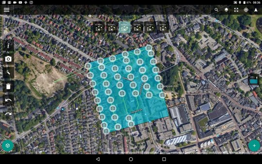
#scan to BIM app
Explore tagged Tumblr posts
Visit Tumblr Blog
Explore Tumblr blogs with no restrictions, modern design and the best experience.
Last Seen Tumblr Blogs


Fun Fact
The Tumblr office adopted Tommy, an 11-year-old Pomeranian.
Text
BIM Scanner app
BIM Scanner is a mobile app for your smartphone or tablet that revolutionizes 3D scanning by offering a seamless way to create BIM-ready models and 3D content directly from your iPhone or iPad Pro. With advanced tools for classification, customization, and content creation, you can align your models with the latest IFC standards and communicate them visually through video, ready for integration…
0 notes
Text
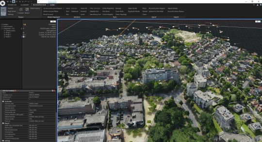
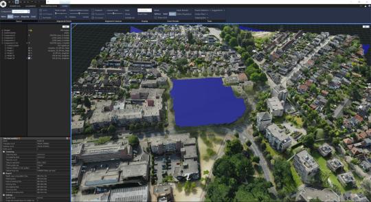
Process of the scan to BIM
INTRODUCTION
The technique known as “Scan to BIM,” or “Scan to Building Information Modeling,” entails creating a Building Information Model (BIM) from point cloud data gathered through 3D laser scanning. The architecture, engineering, and construction (AEC) sector uses this methodology extensively to improve the precision and effectiveness of project design, construction, and management.
An overview of the Scan to BIM procedure is provided below:
Understanding Scan to BIM:
1. Laser Scanning:
Gather Information: Accurate measurements of real-world settings and structures are obtained through the use of 3D laser scanners.
Point Cloud: An extensive dataset of three-dimensional (3D) points that represent the surfaces of scanned objects is produced by the scanner.

Process of the scan to BIM | Virtuconscantobim
2. Data Registration:
Alignment: It is possible to obtain several scans from various angles. These scans are aligned and combined into a single, coherent point cloud by data registration.
3. Point Cloud Processing:
De-noise and eliminate superfluous data points.
Decimation: To make handling easier, decrease the density of the point cloud.
Colorization: Based on scanned surfaces, assign colors to points.
4. Conversion to BIM:
Import Point Cloud Data into BIM Programs: Revit, AutoCAD, or ArchiCAD are three examples of programs that may import Point Cloud data.
Modeling: BIM experts build a 3D virtual model of the scanned area by referring to the point cloud.
5. Advantages of BIM to Scan:
Precision: Laser scanning reduces errors in the modeling process by providing extremely exact measurements.
Efficiency: Provides a thorough reference for design and analysis, which speeds up the modeling process.
As-Built Accuracy: Assures that the virtual model closely resembles the physical structure’s as-built circumstances.
Clash Detection: Assists in finding conflicts between design components and pre-existing architecture.
6. Uses:
Refitting and Renovation: Perfect for projects involving pre-existing buildings where precise as-built data is essential.
Facility administration: Facilitates the development of intricate models for continuing upkeep and administration of facilities.
7. Challenges:
Data Size: Managing sizable point cloud datasets might present difficulties.
Expertise: Accurate data processing and modeling call for qualified specialists.
8. Future Trends:
Automated: Artificial intelligence developments could result in more automated scan-to-BIM workflows.
Integration with AR/VR: For improved visualization and collaboration, BIM models created from scanning data can be incorporated into augmented reality (AR) and virtual reality (VR) apps.
Benefits of the scan to bim
For many stakeholders in the architectural, engineering, and construction (AEC) sector, the Scan to BIM process has many advantages. Here are a few main benefits:
1. Precision:
Precision: By using laser scanning technology, measurements can be made with extreme precision and detail, guaranteeing that the final BIM model accurately captures the scanned environment’s as-built circumstances.
2. Effectiveness:
Time Savings: By offering a thorough and precise reference for design and analysis, Scan to BIM speeds up the modeling process. The amount of time needed for conventional manual measurements and modeling can be greatly decreased by doing this.
Process of the scan to BIM | Virtuconscantobim
3. As-Built Documentation:
Current circumstances: By precisely capturing a building or structure’s current state, the procedure makes it possible to document and comprehend existing circumstances more effectively. For projects involving expansion, retrofitting, or renovation, this is essential.
4. Clash Detection and Coordination:
Finding Conflicts: Early in the project lifecycle, clash detection is made easier by BIM models created from scanning data, which aids in the identification of any conflicts between new designs and pre-existing structures.
5. Improved Decision-Making:
Data-Driven Insights: Precise as-built data minimizes errors and rework by facilitating improved decision-making during the design and construction phases.
6. Visualization and Communication:
Improved Communication: Project stakeholders may more easily grasp the needs and scope of the work thanks to the 3D representation of scanned data in BIM models.
7. Cost Savings:
Minimized Rework: Scan to BIM helps cut down on rework by identifying conflicts and inconsistencies early on, which lowers project expenses overall.
8. Facility Management:
Lifecycle Management: Better maintenance planning and operations are made possible by the use of BIM models created from scanning data in continuing facility management.
9. Safety Improvements:
Remote Scanning: Laser scanning can be done remotely in hazardous or difficult-to-reach regions, saving staff from having to go into potentially dangerous situations.
10. Historical Documentation:
Archival Uses: Scan to BIM offers an extensive digital archive of current constructions, acting as important historical records for later use.
11. Adaptability to Changes:
Iterations in Design: BIM models provide simple revisions and adjustments, supporting modifications in design and guaranteeing that the virtual model stays in sync with any changes made to the real structure.
12. Integration with Other Technologies:
Integration of AR/VR: BIM models created from scanned data can be included in applications for virtual reality (VR) and augmented reality (AR), providing immersive experiences for teamwork and project visualization.

Process of the scan to BIM | Virtuconscantobim
Drawbacks of scan to bim
Although there are many advantages to using Scan to BIM, there are also possible disadvantages and difficulties. To make wise judgments throughout project execution, it is imperative to be aware of these limits. The following are some Scan to BIM drawbacks:
1. Complexity and Learning Curve:
Expertise: Scan-to-BIM implementation that works well calls for expertise in point cloud processing, laser scanning, and BIM modeling. To achieve correct outcomes, one must possess training and knowledge.
2. Costs:
Software and Equipment: Purchasing BIM software and laser scanning equipment can need a substantial upfront investment. The cost of employing qualified experts also raises the total cost.
3. Data Management:
Big Data Sets: The point cloud data produced by laser scanning can be enormous, necessitating a significant amount of computing power and storage for efficient handling and processing.
4. Data Processing Time:
Time-consuming: Project schedules may be impacted by the time-consuming nature of processing big point cloud datasets. The entire processing time is increased by the requirement for extensive data cleaning and decimation.
5. Integration Challenges:
Compatibility Problems: Compatibility problems might arise when integrating point cloud data into BIM software. It can be difficult to ensure smooth data movement between several software platforms.
6. Limited Automation:
Manual Intervention: Despite improvements, there is still a chance that some steps in the Scan to BIM process may need to be done by hand. This limits the process’s ability to be fully automated and efficient.
7. Environmental Factors:
Scanning Conditions: Unfavorable environmental factors, like dim lighting or bad weather, might affect the quality of the results of laser scanning and, consequently, the precision of the point cloud data that is produced.
8. Resolution and Detail:
Limited Detail: The point cloud’s level of detail might not always be able to capture minute details or complex elements, which could cause errors in the BIM model.
9. Lack of Standards:
Industry Standards: Variations in the quality and accuracy of deliverables may arise from the lack of set norms for Scan to BIM processes. Although there are ongoing efforts to standardize, they might not be adopted by all.
10. Project Size and Complexity:
Suitability: For smaller or less complex projects where standard surveying and modeling techniques are adequate, scanning to BIM might not be essential or cost-effective.
11. Privacy and Legal Concerns:
Data privacy: Sensitive information may be captured by scanning existing buildings, raising privacy concerns. It is important to keep ethical and legal issues in mind, particularly while scanning populated locations.
12. Maintenance Challenges:
Updates and Calibration: To provide precise and dependable results, laser scanning equipment needs routine calibration and maintenance. Data acquisition problems might result from maintenance neglect.
Conclusion:
In conclusion, Scan to BIM represents a transformative approach in the architecture, engineering, and construction (AEC) industry, leveraging advanced technology to bridge the gap between physical structures and virtual models. While the process offers numerous benefits, including unparalleled accuracy, improved efficiency, and enhanced decision-making, it is essential to consider potential drawbacks and challenges.
The complex nature of Scan to BIM, requiring specialized skills and substantial upfront investments, may pose barriers for some projects. Challenges related to data management, processing time, and integration with existing workflows must be carefully navigated. Additionally, issues such as environmental factors, limited automation, and the absence of universal standards can impact the overall effectiveness of the process.
Despite these challenges, ongoing advancements in technology, increased industry expertise, and the development of standards are addressing many of the drawbacks associated with Scan to BIM. The potential for improved collaboration, reduced rework, and enhanced project outcomes make it a compelling choice for projects where accurate as-built information and 3D modeling are critical.
As Scan to BIM continues to evolve, it is essential for AEC professionals to stay abreast of technological developments, invest in training and expertise, and carefully evaluate the suitability of the approach for specific projects. By doing so, industry stakeholders can maximize the benefits of Scan to BIM, contributing to more efficient, accurate, and collaborative project workflows in the ever-evolving landscape of construction and design.
#Virtucon#VirtuconEngineeringLLC#VirtuconScantoBIM#CADservicesprovider#AECindustry#CAD&BIM#Architecrute#2dAsbuiltdrawings
0 notes
Text
Scan to BIM or CAD by Space Capture App

Scan to BIM or CAD by yourself is never easy like today with the Space Capture App. Capture & scan anything with an iPad or iPhone and Convert the data into 2D plans and 3D BIM models.
#lidar room scanner#lidar scanner 3d app#room scanning app#ios scanning app#lidar scanning apps#scan to BIM App
0 notes
Text

Now you can choose the Scan to BIM option and convert the scanned data into 3D BIM models easily. Use the LiDAR installed for your iOS device and scan the room or a space and get the scanned data while will be further converted into the 3D BIM models while going for the Scan to BIM.
0 notes
Text
3 Ways Virtual Reality is Solving the Bottlenecks of Construction Industry
Breakthrough technologies are constantly shifting the way construction is done, from apps on mobile devices to drone photogrammetry and laser scanning. Virtual Reality is one technology that is redefining the construction industry by not only introducing new ways of carrying out processes but also by addressing bottlenecks in an efficient manner. Just like with any innovation, VR has struggled for adoption across industry segments as only a minuscule segment of the construction industry have adopted this technology. But they are reaping substantial rewards from it, whereas the rest are still sitting on boundary.
Virtual Reality in construction is a step ahead of 3D modeling. It involves a detailed virtual model of the project like 3D modeling, but with users fully immersed in the virtual space created for enhanced visualization. Here are 3 ways of how the new age Virtual Reality technology is providing solutions to old construction problems:
Easy access to Information:
It is easier for newer teams to collaborate and access relevant information from any location with Virtual Reality. Every building is different and unique, and VR allows creating a detailed, accurate model at a faster and cheaper rate. Not only this, but VR also makes it possible to share the same models across teams. Virtual Reality has taken 3D modeling to another level by making it possible for people to immerse themselves in the project as though they were engaged in an interactive walk-through with the design environment.
A 3D model was basically a miniature model, but Virtual Reality is a very minutely detailed and accurate version of the same reality.
2. More Efficient Collaboration:
The benefits of the technology are relevant when it is difficult to commute to remote sites of construction. It has enabled people to ‘see’ the project without travelling to it. Virtual Reality makes it easier for teams to collaborate, talk, and share views in real-time, within a shared and contained environment. The use of Virtual Reality has optimized work timelines by facilitating immediate feedback, reducing reworks, and improving the level of accuracy.
3. Immersive Customer Experience:
Today, Virtual Reality is changing how people involved in a project will be immersed in it. Construction companies are adopting VR technology to establish a transparent client-company relationship avoiding any anger or frustration during the construction process. Instead of paper and pen drawings and plans, clients can walk through the whole building/project through a Virtual Reality model, and see for themselves how the project will look like and track the progress. Client’s feedback is the utmost priority, through VR immersion; clients are empowered to make suggestions and decisions.
With the above reasons mentioned, Virtual Reality can provide a new way for commercial property owners to market their space long before construction completes. The technology will allow potential buyers to see how the space will look like, including views, lightings, furnishing, etc. and invest in the project with speeding up the revenue for commercial projects.
Conclusion:
Virtual Reality is helping the AEC (Architecture, Engineering, and Construction) Industry by improving communication, streamlining collaboration and enhancing the customer experience. VR technology is providing solutions to old and any new problems and creating a more sustainable, profitable and satisfying client-customer experience.
TechnoStruct is an emerging name in the Design & Construction technology space It specializes in engineering and designing industrial, commercial, high-tech manufacturing, co-generation, solar power, and water infrastructure projects. TechnoStruct has a hold in technology and has a diversified range of services available, apart from BIM, like MEP engineering and designs, Mechanical Subcontractor, Solar, Electrical Subcontractor, and many more.
#BIM service providers#BIM service providers in CA#BIM consulting firm in CA#BIM consulting firm#BIM consulting services
1 note
·
View note
Text
What is the function of the Building Information Model (BIM)?
"BIM" stands for "Building Information Modeling." Building Information Modeling, or BIM, is rapidly replacing traditional construction planning and management methods. It's how data about a building project is compiled and maintained. BIMs, or Building Information Models, are the digital files resulting from this process and detail every project facet. With this information, you'll have a leg up on making smart choices throughout the project.
What is BIM?
The BIM process involves creating a digital model of a building's structural and operational details. BIM, or building information modelling, is a repository of data and knowledge about a building that can be used as a solid foundation for decisions throughout the building's history, from design through deconstruction.
Aside from geometry, Bim Modelling Services also makes use of other tools. Quantities and characteristics of building components, spatial linkages, geographic data, light analysis, and more are also covered.

Why BIM is important
Accurately show what the site looks like
Advanced design and mapping tools are put to use in BIM. The use of three-dimensional scanning, for instance, has grown in popularity to create accurate three-dimensional models of buildings and other sites. Point clouds are generated by rapidly firing thousands of laser pulses in a matter of seconds, which are then transformed into 3d Motion Graphic highly representative of the real environment. Digital imagery of greater areas can be captured by using drones or aircraft.
The most efficient method of working together
During a building's construction, numerous parties may have vested interests. Everyone involved in the project, from architects and contractors to engineers and clients, must lend their knowledge to make the model. A cloud-based, centralised database containing various BIM tools and capabilities enables real-time cooperation between all parties. Working together this way is not conceivable with paper or even many digital platforms.
Achievable with little effort
Conventional, stand-alone Cad Design Service is very resource intensive, consuming a lot of computer memory. Users of BIM and other cloud-based apps like it need not worry about system resources or speed. Besides, you can get to them anywhere, and on any gadget you like.
Manage activities and processes in tandem
Each construction phase can be represented by a separate sub-model of the 3D floor plan services produced by BIM. These may be made to update and evolve automatically, saving much more time during the design process.
Moreover, experts in the building industry, such as engineers, architects, and construction workers, would have a resource to consult for an in-depth understanding of even the tiniest architectural details. As a result, construction can be carried out painstakingly to ensure that physical structures are an exact reproduction of their digital counterparts.

Save building information for future use
BIM blueprints have applications beyond the building industry. When construction is finished, the building manager receives access to the database containing all pertinent information on the structure. Building managers can now quickly and easily access key data about the building they oversee.
Conclusion
A building manager, for instance, can use a 3D model to investigate a leak and locate the main water supply, inspect for electrical risks, and identify other potential concerns. The repair crew will be able to formulate a solid plan with the help of this data, which will be of great use to them.
0 notes
Text
Emerging Trends in Construction Technology

Emerging construction technology isn’t just a fad. Modernizing your existing processes has beneficial, practical applications.
In order to stay competitive and avoid falling behind, construction businesses are figuring out how to adopt new methodologies into their workflows and strategies.
Recent Construction Technology Trends
The main civil engineering construction technology trends for 2023 and beyond are listed below.
Building Information Modelling (BIM)
BIM is similar to CAD (computer aided design) but not the same. It is a 3D design software used to simulate what will be created digitally. It does not only produce a visually appealing 3D model of the building, but it also adds numerous metadata layers and presents them in a teamwork environment. BIM also helps in problem-solving during the design and planning phases of a project by automating clash detection.
Cloud & Mobile Technology
Mobile technology isn’t just for games anymore. In actual construction, apps are more common. The improved accessibility of tablets and smartphones enables more effective communication and remote working.
This has many important benefits, including storing almost limitless amounts of information that you can instantly share with a button.
Drones or Unmanned Aerial Vehicles (UAVs)
The most popular construction technology are drones. They are less expensive than aerial photography and can carry out site surveys more quickly and precisely than a staff on the ground. They can take volume measurements and produce dynamic 3D or topographical maps and models.
Using drones allows for safe inspection of high-rise structures and other difficult-to-reach areas.
Virtual Reality (VR) – Construction Technology
VR technology is often used in conjunction with BIM to help better understand of complex projects. It is one of the most emerging trends in constructions and civil engineering. Using VR will give your team or the client an even more realistic idea of the project.
Augmented reality (AR)
Irrespective to the Construction World’s fact that virtual reality has become increasingly popular over the past few years, it is soon turning outdated, especially when compared to the uses and advantages of AR (augmented reality).
This is the ability to visualize the natural world through a camera lens. It’s something that’s bound to open many new opportunities for the construction industry.
Prefabrication – Construction Technology
In prefabricated construction the sections of walls, floors and roof are prefabricated (assembled) in a factory (possibly with window and door frames included), transported to the site, lifted into place by a crane and bolted together.
Prefabricated steel and concrete segments are the most often utilized type of prefabrication in civil engineering and building projects where a specific element or form is repeated frequently.
Laser Scanning in Construction
Laser scanning helps to reconstruct old buildings or heritage monuments without demolishing them. The most important step in renovating or refurbishing is to evaluate and get the building structure and to confirm the new design. This enables the creation of a 3D BIM model that includes details such as beams, doors, windows, slabs, columns, or any MEP components. The clash detection and interference checks are carried out using these BIM models. Given that the as-built model is only based on the laser scanned photos of the building, laser scanning to BIM modelling services offers increased accuracy.
Self-healing concrete – Construction Technology
Self-healing is actually an old and well-known phenomenon for concrete as it possesses some natural autogenous healing properties. Cracks may eventually close due to the continuous hydration of clinker minerals or the carbonation of calcium hydroxide (Ca(OH)2). Autogenous healing is tough to manage because it can only repair small cracks and works best when there is water present.
Smart Buildings – Construction Technology
A smart building involves the installation and use of advanced and integrated building technology systems. These systems include facility management, telecommunications, user systems, and building automation. To help the building owner to manage the building or space, smart buildings offer actionable information about the building.
Conclusion
Undoubtedly, 2023 and beyond is expected to be a breakthrough for the construction industry. To adapt to future technology you must choose the best builders & developers. SR Construction, one of the leading villa Builders in Coimbatore will help you to emerge into new advanced technologies.
0 notes
Text
Download Reality Capture crack (license key) latest version G7LU+

💾 ►►► DOWNLOAD FILE 🔥🔥🔥 Useful for producing 3D articles in the own photos along with scans in reality. Reality Capture Crack can be utilized for developing 3D maps. Therefore, Only you ought to have a couple of images and make 3D content mechanical in only two or three moments. The consumer may reach their struggles radical boost product. Therefore, it can use to turns pics to 3D types Produce 3D types format at an excellent calibre and precision. Therefore, it can use to Mix unique inputs for a visually steady inguinal 3 d variation. Without limits. Reality catch is a fully-featured working with a rich easy-to-use UI, incredibly. Innovative hub and with a couple of Reality Capture Serial Key which drives the envelope of everything can be achieved with all the: unbelievable Rate, quality having a lesser requirement in your components. Truth Grab significantly enhances the product, precision, good quality, and protection throughout your undertaking. Carry your digital camera mobile; it will not have to be an expensive expert camera shoot any graphics and produce 3 d articles within merely a couple of moments. RC is not challenging to use with intuitive UI and tutorials. Truth Grab is a photo program option that may allow you to make 3D designs from laser or photo scans. While lowers some time and manual work demand. Therefore, the Reality Grab is the connection involving uncooked site states and also a clever BIM surround. Truth Catch Pro can it be, and the section of the software is also referred to as gallop. Hence that your fantasies will soon become a reality, they know of the way people running a business always appreciated my work. Reality Capture Torrent plays three stages capture, computation, along generation. Truth Capture Pro is photography software that results in 3D versions from unordered laser or photo scans with no seams. Even the absolute most often regions of its utilization are a simple fact, broadly speaking human anatomy scan. While, the gaming, studying, mapping and visual effects, and legacy. Reality Capture Key can be the tool of solution which is currently adjusting the organization. It enables you to focus on your targets, attracts for work, also will be just ten times more rapidly compared. While the other two other things on the present market. Digital reality screens textured 3D meshes project maps along with further scans. It is the use of the option to get a wide variety of organizations. Reality Capture Product Key grows software for model and filming out-of different tools and graphics. We mean to extend an excellent substitute. We assemble higher-excellent app growth run over the very last a long time and also research. How to Crack? Your email address will not be published. Save my name, email, and website in this browser for the next time I comment. Also, download the software, While installing the crack, Therefore, generate crack there, Similarly, the reboot system And you have done, Enjoy Crack! Official Site Link. Drawboard PDF Pro 5. Radmin 3. Posts You May Like. Leave a Reply Cancel reply Your email address will not be published.
1 note
·
View note
Text
Resource Augmentation: A framework that ensures smooth project continuity for AEC firms.
As construction projects advance through various building phases viz. planning, design, and construction, they require exceptional team expertise to ensure project success. However, AEC firms face staffing challenges on account of greater infrastructure and hiring costs, employee liabilities, and employee training. The evolution in the AEC sector through cloud-based apps, video collaboration, and remote working has opened doors to a larger talent pool. Creating development centers offshore drives improved realignment of organizational framework and lower cost overheads.

Resource augmentation services (RAS) for Architectural Modeling, Structural Modeling, MEP modeling, clash detection, laser scanning, and 360 reality capture on a monthly, quarterly, or yearly basis with resource loading or acquisition ensure firms lay greater focus on their project.
AEC firms come across staffing problems during staff transition or the need for a quick ramp-up. Understanding the demands of construction projects with RAS eliminates excessive cost overages, project delays, and administrative overheads that come up with training and hiring new employees. BIMe offers AEC firms a scalable and cost-efficient RAS framework to lower project costs, mitigate delays, and produce high-quality outcomes.
As one of the fastest-growing BIM firms and RAS consultants in the United States, BIMe provides critical support through the entire planning, design, and construction lifecycle.
We ensure you have the expertise to rapidly scale project demands.
Whether you require value-added resources to augment your construction project or need an entire team for the entire duration, BIMe can augment your AEC firm in the following capacities -
· Construction management
· Evaluate risks
· Review constructability
· BIM modeling
· Assessing productivity
· Construction estimating
· CPM Scheduling
· Analyze claims
Finance plays a critical role in project decision-making when it comes to staff loading or augmentation. Greater cost overages burden a project and AEC firms. BIMe ensures these cost overages are lowered with a RAS framework from BIMe. The top benefits of partnering with us to augment resources include,
· Zero investment required
· Managed resource hiring
· Monthly, quarterly, and yearly framework
· On-demand scaling
· Competitive pricing model
BIMe USPs for Resource Augmentation Services (RAS).
· Higher Technical Advantage
· Reliable Autodesk Partnerships
· Flexible engagement models enriched with scalable resources
· Centralized location in the US
· Skilled and on-demand resources
· Office extension for onshore and offshore needs
· High-quality and global references
BIM construction management is reinforced with technology and transparency.
· iFieldSmart construction management tool for project management
· Track project status at any project milestone
· Expedite the project as and when needed
· Quick and accurate billing through precise hour calculation and resource utilization
· Teams can communicate and collaborate on project tasks
· Identification and resolution of risks
· Quick and accurate project planning and scheduling
· Precise manpower utilization and hour calculation for the project
· Improved management of project scope
Process and Quality Improvement.
Our capabilities make sure the model geometry is created with accurate LOD, precise location, and a clash-free and compliant system.
· Establishing workflows and best practices
· Model approval, saving, and sharing
· Producing model audits based on a pre-established checklist
· Validating design using pre-defined parameters
· Enforce organizational QC standards
· Long-term resource engagement enriched with the adoption of QC checklists
· Trained resources well experienced with existing AEC norms
· Process refinement and improvement on a perpetual basis
Resource Augmentation Services features from BIMe.
· Mitigated hiring hassles
· Extended or dedicated project teams
· Monthly/Quarterly/Yearly RAS model
· Quick resource Ramp-up
· Improved data security
· Strong training model
· Simplified accounting with improved financial transparency
· Greater productivity levels reinforced with reduced operating costs
Conclusion.
RAS can economize your project costs within the AEC industry. Firms can leverage a strong RAS model to achieve a competitive advantage and a larger talent pool. We can help you achieve long-term project dividends with lower infrastructure costs, lower overhead, quick turnaround, low-cost buffer, and industry-ready professionals. Contact our team to augment your team and ensure a successful construction project.
Contact Us: - 703-994-4242
Visit us: - www.bimengus.com
0 notes
Text
Learn why photo documentation is important in construction and how it can save thousands of dollars
Tracking project progress is easier said than done right. Improving project visibility can help contractors make informed calls. Sound field documentation showcases a construction company’s ability to win projects. Building a digital record of the project to document As-Built conditions enhances accountability, efficiency, and saves thousands of dollars.

Traditional field documentation processes or tools are unreliable sources of truth. Inaccurate, incomplete, and fragmented documentation can create a damaging impact for contractors and facilities managers during construction, facilities management, or renovation. Owning a set of unreliable documents can create onsite clashes, rework, greater RFI requests, change orders, and other challenges. By reinforcing photo documentation to track field progress, construction companies can ensure the accuracy of project data “through pictures”. Photo documentation linked to highly accurate laser scans, BIM models, and drawings can help reduce project risks, review project progress, and enhance building performance.
Here’s how photo documentation can improve construction and save thousands of dollars.
Remotely view what’s happening on your job site.
Photo documentation can help contractors and other stakeholders visualize project progress through remote technology. Instead of looking through inaccurate and fragmented notes, teams can leverage high-resolution images stored on a cloud-based platform. With complete access to data from a source of truth, teams can save field time and get a complete picture of the job site with regular and updated reports.
Photos help you visualize how subcontractors are producing high-quality work and following onsite safety measures. The use of laser scans, 3D BIM models, photos, and 2D drawings help teams identify hazardous spaces or construction risks. Remote access capabilities through web and mobile apps drive true collaboration to store, access and share data with other team members.
Annotations or markups linked to photos highlight critical project data.
Markup or annotation capabilities help construction crews visualize highlighted areas. Captions or descriptions about construction components or equipment make it easier to draw intelligible ideas on project progress through enhanced documentation. When looking for photo documentation software reinforced with advanced construction management, select one with AI-based capabilities like Lens 360 and iFieldSmart Technologies.
Draw actionable insights through side-by-side comparisons.
Performing side-by-side comparisons of 360 photos with 3D models helps review project progress of various locations over time. Validating onsite components and equipment through various timelines and project progress increases clarity and precision as everyone stays on the same page. Comparing before and after photos when milestones are achieved helps track work, logistics, and resolves potential issues. It isn’t just daily reports that are improved, closeout inspections, change requests, and punch lists can be augmented. Punch lists linked to high-resolution pictures can help teams identify and resolve issues leading to quicker close-outs.
Build better clarity to the scope of work.
Taking 360 photos and comparing them with existing laser scans or BIM models can draw better clarity of work scope or changes in the scope of work. Foundation cracks, mold, environmental moisture, or framing can be documented by contractors the moment they arrive onsite. Taking accountability for issues before other teams or contractors can find it can help resolve issues faster with complete answerability. Field documentation reinforced with photos improves closeout outcomes.
Improve construction project management.
Site managers and foremen spend numerous hours onsite to inspect work and issues that include change orders, RFIs, onsite conditions, etc. Onsite crews can save time for managers by photo-documenting job sites to make informed decisions. Actions can be confirmed with updates without making frequent site visits. Keeping accurate timelines reinforced with field documentation ensures all the data is organized for enhanced project management.
Conclusion
Save time and money with proactive construction photo documentation. Communication and collaboration are crucial for any project, but they can be easily augmented with documentation for various milestones viz. before, during, and handover. Documenting As-Built conditions to manage critical issues, creating detailed O and M manuals, and producing progress reports in real-time for billing and scheduling can help contractors garner cost-effective outcomes.
For more information: +17034688575
Visit us: - www.ifieldsmart.com/
#ifieldsmart#Team Management Software#Clash Detection Process#Project Collaboration Software#Clash Management Process
0 notes
Text
Drone-to-3D workflow for architectural visualizations
Architects and designers often need to know how a design will be incorporated into its real-life location, while clients and “non-architects” turn to photorealistic visuals (images, videos and more) for a deeper, more visceral understanding of the project and the architect’s intentions.
Story by Pjotr van Schothorst, Lumion ([email protected]).
Nesselande Project with context made from this drone-to-3D workflow.
While working in Lumion, features such as OpenStreetMap (OSM) and satellite ground planes can provide some context for your design. They are suitable options for quickly building urban or rural environments relevant to your project’s location, but they’re also limited.
For instance, OSM only provides rough building shapes, rendered white, and the satellite maps are flat, often outdated, and the resolution is too low for client visualization.
NYC skyline with context provided by OpenStreetMap, rendered in Lumion 8.3.
This all got me thinking — there has to be a better way to improve fast context-building without having to sacrifice photorealism. I investigated several options, starting with Google Maps and Google Earth SDKs, but these services do not allow their data to be used outside the scope of Google Maps and Google Earth, such as for architectural visualization.
One solution is to create a 3D model of the environment using a series of photographs taken by a drone. This technique is sometimes used at construction sites to monitor progress, but it is not yet widely used for architecture design and visualization.
To test its viability, we used a drone-to-3D workflow for several real-life design projects. From our experiences, we derived a workflow simple enough to be used by architects (and not only 3D specialists). Using a modern drone and the software RealityCapture, it is now possible to capture an area of 300x300m and create a textured 3D model of sufficient quality for presenting a realistic background for your Lumion visualization.
Oh, and you can do all of this in one day.
Workflow Summary
This summary is a condensed version. Click here for the full drone-to-3D workflow story (PDF).
Step 1: Buy a Drone.
Drones are getting cheaper, smaller and increasingly powerful by the minute. For this workflow, I used the DJI Mavic Air. It costs $800, weighs less than half a kilo and it can fly for 20 minutes on one battery. The DJI Mavic Air can also cover a distance of 10km and make 4K video and 4000x3000 images with good resolution. This is adequate for our purpose of creating 3D environments as a backdrop for architecture design or visualization.
10-inch tablet and tablet holder next to the DJI Mavic Air.
Also, I’d recommend that you buy some extra drone batteries and, if needed, a 10-inch Android tablet.
Step 2: Capture Drone Images.
Using a special app on your tablet for controlling a drone, e.g., Drone Harmony, the second step is to capture images around the area of interest.
The Drone Harmony app lets you draw the area of interest on a map, and then it calculates the flight path of the drone, capturing images automatically with a 60% overlap from the previous shot. This overlap is needed for automatic 3D model construction.
Example flight path in Drone Harmony.
Do five runs of the same flight path above the desired area, but make sure you assign a different camera angle for each flight. For instance, you can fly the first run with the camera pointed down and the other four runs with the camera tilted at 45 degrees. Each run takes 7 to 15 minutes, so the entire flying will take about 1 to 1.5 hours overall.
Step 3: Enter images into RealityCapture (RC).
While there are many different software programs for compiling drone images into a 3D model, I found RealityCapture as the best option. RealityCapture automatically aligns all of the images and then it creates a 3D model, adds textures and inspects the model’s quality. This literally takes a few minutes of manual work, and a few hours at most of background processing by the RealityCapture software.
Constructed 3D model after RC aligned and processed the images from your drone flights.
Step 4: Cut out the lesser detailed areas and unwanted objects.
If the quality of the model is OK, the next step is to cut out the lesser detailed areas and unwanted objects, and then simplify the 3D model to a smaller model. Depending on the model’s size and complexity, this can be anything between 30K and 1M triangles.
Cut out a specific area where you will insert your CAD building or spaces.
Texture the model again and export it in an FBX format. Cutting and simplifying the model takes between 20 minutes and one hour.
Step 5: Import the model into Lumion.
After importing the 3D drone model into Lumion, you can dress it up with trees, cars, people, furniture, etc. You can also import your design from SketchUp or your CAD/BIM program (Revit, 3ds Max, AutoCAD, Rhino, etc) on a separate layer. Make renders and animations.
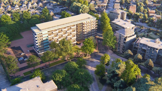
Westpoint Apeldoorn Project, rendered in Lumion 8.5 after going through the drone-to-3D workflow.
This typically takes anywhere between 15 minutes and several hours.
If you want the full story, with detailed information and tons of great images and videos, check out the full Drone-to-3D workflow (PDF).
Testing the Workflow on Real-Life Projects
I used this workflow for several projects. One is a test project of a beach and dune area featuring an existing Lumion example house. The following two are commercial design projects from local architects. These are briefly described in the next sections.
Beach and Dune Area
Test project. Existing Lumion beach bungalow added to a 500x500m captured beach area near The Hague, The Netherlands.
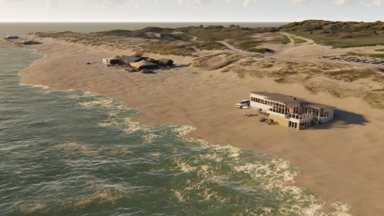
Animation of the Dune and Beach Project
Nesselande Project
Private house design on a small island in a new residential area near Rotterdam, The Netherlands.
Architect: Studio Aaan.
From the architect: “The house is located on a private island in a new urban development close to the city of Rotterdam. The house is oriented towards the new park located on the next island southwards. In order to be able to enjoy the views, the living areas are projected above the surrounding dike levels and the sleeping areas are located below. The lower floor is half sunk into the island and is organized around two patios. As a structuring design principle, the roof consists of expressive wooden beams in a dense pattern. The beams create a canopy on the south facade as well as a characteristic interior ceiling.”
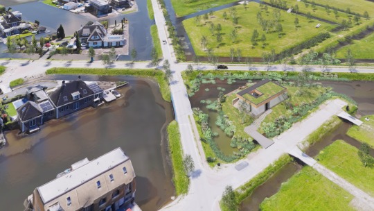
Studio Aaan’s private home design (center right) in a 3D model of the real-life neighborhood of Nesselande, The Netherlands.
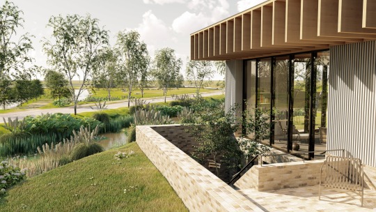
Nesselande project detail
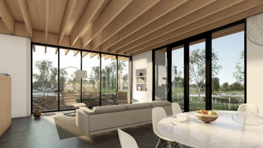
Nesselande project interior
youtube
Nesselande project animation
Feedback from the architect, Hilbrand Wanders, of Studio Aaan: “For any architecture project, but especially a private, freestanding housing project, the interaction of the building with its surroundings is crucial. We want to study the project as an architectural object on its location, but also want to consider how the surroundings are experienced from the interiors. Only once a house is finished and the owners move in, one can precisely see how certain trees are creating shadows in the house, what objects in the surroundings are blocking views from a certain position, or how window openings are positioned relative to window openings of the surrounding buildings. These aspects are highly influential on the living qualities and are difficult and too time-consuming to model by hand completely early in the design process. It is very interesting for a designer to consider the correct 3D environment from the first moment on, to test the first design-ideas within a correct 3D surroundings, but also to communicate these to a client in a very clear and tempting format. In the case of this project, the fact that the views on the site were blocked by surrounding dikes, were the reason to place the living rooms on the first floor. All other design steps (bedrooms around patios in souterrain, the stepped garden wrapped around the house) were consequential to this notion.”
Westpoint Apeldoorn Project
Refurbishment of an existing office building into 98 apartments, each with a balcony, in Apeldoorn, The Netherlands.
Architect: Paul Spaltman
Paul Spaltman’s design of a refurbished office building in Apeldoorn, The Netherlands.
Another aerial render showing city context created from the Drone-to-3D workflow.
Front of the Westpoint Apeldoorn Project
Animation of the Westpoint Apeldoorn project:
youtube
Feedback from the architect, Paul Spaltman:
“Even though the 3D scan isn’t completely perfect, I can say that it offered an enormous additional quality and offered many new options. The fact that my design was embedded so clearly in the environment is an added value, not only during the design, but also during presentations and discussions with the customers, governments, and local citizens or whoever is involved. My client called that he is really positive about my design, and he will now discuss it with the city council (landscape, urban design, review etc.). The plan to replace the existing building is a sensitive topic with the people living in the area, so everybody is super critical. The 3D scan of the environment will play an important role in this approval process.”
Cost Overview
The following table sums up the software and hardware components I used. Other components may be needed, with additional costs, as well.
Creating your own 3D environments with drones
My experiences have shown that creating 3D environment models from drone images is very straightforward and feasible for any architecture design visualization.
The investment in time and money is relatively low, and any architect can do it without extensive training and/or the need for a 3rd-party service provider. The resulting models have value both in the design process (Lumion LiveSync) and for communicating with clients and other interest parties, like the city council and local citizens (Lumion rendered images and animations).
#lumion#lumion8#architecture#architect#architectural design#architecturelovers#archilovers#building#design#CAD#cad design#architectureporn#modern#modern architecture#dronelife#drone#dronestagram#droneoftheday#aerial#imaging#3D#3dmodel#3drendering#render#architecturerender#context#city#neighborhood#software#sketchup
3 notes
·
View notes
Text
The Secret to Higher Performance and Lower Cost Construction Projects
The construction sector generated revenues of $2 trillion in the United States in 2019 and made a contribution of 4.1% in the country’s GDP in 2020. While 2020 was upended by the pandemic, construction continues to remain a core sector relevant for national and global economies. That said, becoming and staying successful is hard here. Construction companies face several issues, such as the rising cost of material, disrupted supply chains impacted by the pandemic, lack of talent, and inconsistent technology use. Issues like these lead to project delays and safety concerns resulting in adverse impacts on the cost and performance of the construction projects.
Can the construction sector learn from the experiences of other business sectors and create more opportunities for profits and better business outcomes?
Here are a few strategies that construction firms can adopt to achieve high performance at a lower cost without any compromises on safety and quality.
1. Improved Planning
Cost and schedule overruns are perennial concerns and are cited as the main causes of failure of construction projects. Planning is an essential activity that can be integrated with advanced analytics and technologies for improved performance and results.
• Data Analytics Tools: Special data analytics tools designed around Big Data and Business Intelligence concepts can assist Construction Managers to correctly schedule resources and the raw material needed, internal and external risks that may get involved, the estimated duration for each stage of the project activities, etc.
• Cost-Benefit Analysis: A more systematic budgeting and planning procedure can assist the construction team and the contractors to determine project costs, projected cash flows, and the associated margins and their timing better and more transparently. The exercise can become more inclusive by inviting participation from more people and providing richer and more comprehensive data.
2. Building Information Modeling (BIM) and Computer-Aided Design (CAD)
BIM is a collaborative technique to develop three-dimensional models for construction projects to enable effective decision-making. Construction companies can adopt BIM techniques to come up with properly analyzed designs. Insights are available from each of the core steps designers and architects follow in BIM as pre-design, schematic model, schematic design, interference checks, element ownership, and construction.
The models allow the construction teams to view the three-dimensional view along with the 4D and 5D visualizations for time and costs respectively to make better resource estimations and better plans. BIM also anticipates the operational and maintenance costs for calculating the detailed project budget. Technical drawings can be enhanced to achieve high-degree precision making errors and conflicts visible early in the cycle.
With technological advancements, construction firms can now integrate BIM techniques with the latest innovations for even greater value. For instance, Augmented Reality (AR) and Virtual Reality (VR) can further improve the visibility of the designing options. Approximately, 80% of the average cost overruns in construction projects occur due to change orders. However, with in-depth and accurate designs, better planning, and clash detection through BIM, the probability of such changes reduces. This in turn can allow improved performance at lower costs.
3. Modular Construction Approach and Pre-fabrication
The modular construction approach involving pre-fabricated elements can be an effective method to improve the performance and check the costs at the same time. The modular construction projects are being seen to be 30-50% faster than traditional construction projects. One of the major benefits of building modular is the elimination of at least 80% of the actual construction activities from the actual site location. This saves time, effort, and money. Reduced activity on-site also improves safety.
The construction sector has a major role in global pollution levels and climate change. It contributes 23%, 40%, and 50% towards the air, water, and land pollution respectively. The modular construction approach can involve eco-friendly raw materials and can also use recycled materials. The building structures developed also promise improved energy-efficiency. Also, sound insulation and fire-proofing are certain with durable materials used in modular construction. Prefabricated construction reduces the overall timeframe of the construction project automatically leading to lower costs.
4. Construction Software and Technologies
Technology should be used as a powerful tool to streamline construction activities and enhance the performance of construction projects. Several mobile apps can be used in construction projects for improving communication, collaboration, monitoring and tracking, reporting, safety, and compliance. As more data-focused tools come into play, more data becomes available for analytics too. Real-time site reports can be generated and shared through these apps for quicker communications and problem-solving. Remote equipment tracking and monitoring are also one of the features offered by the construction mobile apps. Better insights can be gained on the equipment data, usage, and performance. Such capabilities can assist the construction managers to carry out better planning and control.
Surveillance technologies can also be used at the construction site to ensure the safety of the construction workers. The use of drones can allow remote site monitoring and alerts can be generated in the possibility of site accident.
Project management and fleet management software packages can also be used to boost productivity levels, control costs, and achieve better project outcomes.
Brief Summary
Performance improvements and cost reduction are two elements desired by every industrial and business sector. That applies to the construction industry as well. A winning combination of technology, strategy, and operational excellence can enable construction companies to bring down costs and enhance performance. BIM techniques, modular approaches, data-driven planning, and construction technologies can allow construction companies to balance project performance, costs, schedule, and quality. That said, it’s clear the challenge is no longer the availability of tools, technologies, and methods. The biggest problem construction companies face is how to find the talent with the capability and the interest to make the most of these tools and technologies and how to enable and empower them to deliver at their best. But that’s a story for another day.
BIM Consulting Services BIM Services BIM Project Management Solutions
Architectural BIM Services, Structural BIM Services, Scan to BIM Services, Point Cloud to BIM Services, 3D Revit BIM Modeling Services, MEP shop Drawing Services, 2D Shop Drawing Services
BIM Drafting Services CAD Services
0 notes
Photo

Bên cạnh những hỗ trợ về chính sách của Chính phủ để phục hồi thị trường BĐS giai đoạn Covid-19, một số doanh nghiệp BĐS đã tỏ ra nhạy bén với những biến đổi của thị trường trong tình hình dịch bệnh như hiện nay. Đặc biệt là sự tác động của việc giãn cách xã hội định hình lại hành vi của người tiêu dùng. Do vậy, việc tìm ra cách thức bán hàng thích ứng với sự thay đổi đó là yếu tố quan trọng giúp các doanh nghiệp BĐS hạn chế rủi ro và gia tăng doanh thu trong khi các doanh nghiệp khác vẫn bị động trước dịch bệnh.
Tại Việt Nam, một số doanh nghiệp BĐS đã tiên phong ứng dụng công nghệ vào hoạt động kinh doanh, trong đó có thể kể đến những cái tên tiêu biểu như VinGroup, Sunshine, Bim Land, Đại Phúc Land, CT Group,… Trong đó, các App bán hàng tỏ ra có hiệu quả và hỗ trợ đắc lực cho các doanh nghiệp tiếp tục duy trì hoạt động thay vì phải “giãn cách” bán hàng.

Các App bán hàng đã hỗ trợ đắc lực cho các doanh nghiệp tiếp tục duy trì hoạt động trong mùa dịch Covid
Đáp ứng nhu cầu đó, Tập đoàn công nghệ bất động sản hàng đầu châu Á PropertyGuru hiện đang sở hữu nền tảng bán hàng FastKey hỗ trợ số hóa và tự động hóa quy trình mua bán bất động sản. FastKey hiện đang được áp dụng với hơn 500 dự án BĐS ở nhiều quốc gia trong khu vực. Được giới thiệu tại thị trường Việt Nam vào năm 2019, FastKey thu hút sự chú ý của nhiều doanh nghiệp BĐS, đặc biệt sự quan tâm ngày càng cao từ khi dịch Covid-19 bùng phát. Sự ảnh hưởng của dịch bệnh đến hoạt động bán hàng BĐS là một động lực to lớn khiến các doanh nghiệp nhận thức rõ hơn về tính hiệu quả mà công nghệ mang lại.
Gia tăng sự kết nối và trải nghiệm từ xa
Theo đánh giá của bà Nguyễn Thị Thanh Hương, CEO Đại Phúc Land: “FastKey giúp nhân viên kinh doanh có sự chủ động và thuận tiện hơn rất nhiều trong quá trình tương tác với khách hàng".
Với yêu cầu giãn cách xã hội, NVKD khó có thể gặp gỡ khách hàng để tư vấn trực tiếp, cũng như đưa khách đến nhà mẫu, tham quan dự án. Thay vào đó, tính năng bộ tài liệu bán hàng được số hóa và tích hợp trên một nền tảng thống nhất của FastKey sẽ giúp khách hàng cũng như NVKD nắm bắt thông tin dự án một cách đầy đủ nhất với giao diện trực quan, sinh động.
Các nội dung trong bộ tài liệu bán hàng của FastKey được cung cấp bởi chủ đầu tư làm giảm thiểu các thông tin sai lệch, đảm bảo hình ảnh thương hiệu của dự án và chủ đầu tư, từ đó, tạo thiện cảm và gây ấn tượng với các khách hàng tiềm năng.
Ngoài ra, Tập đoàn PropertyGuru cũng vừa ra mắt Storyteller – tính năng mới của FastKey giúp số hoá hình ảnh 2D của dự án thành không gian 3D sống động. Tính ưu việt của Storyteller so với các sản phẩm 3D Scanning, thực tế ���o, đó là ngoài việc xem không gian dự án một cách chi tiết đến từng căn hộ, khung cảnh xung quanh dự án với các tiện ích lân cận, thì khi tích hợp với hệ thống dữ liệu của FastKey, người mua nhà có thể tìm kiếm, lựa chọn các căn yêu thích dựa trên vị trí căn hộ trong dự án cũng như cân nhắc các yếu tố khác như mức giá, diện tích,… thông qua bảng hàng được cập nhật liên tục. Từ đó có thể kết nối nhanh chóng với đội ngũ NVKD của chủ đầu tư hoặc sàn môi giới để được tư vấn và cung cấp thông tin chi tiết về dự án. Storyteller hỗ trợ các chủ đầu tư có thể tiếp cận thị trường ngay khi dự án được phê duyệt mà không cần chờ đến khi xây xong nhà mẫu, cho phép khách hàng khám phá và trải nghiệm các dự án BĐS mọi lúc, mọi nơi.

Nền tảng bán hàng FastKey hỗ trợ số hóa và tự động hóa quy trình mua bán bất động sản
Sự ưu việt trong tốc độ và tính linh hoạt
Với thời gian cài đặt nhanh chóng chỉ từ 21 ngày, doanh nghiệp đã có thể ứng dụng ngay FastKey vào hoạt động bán hàng, cung cấp cho đội ngũ NVKD công cụ để tư vấn và giao dịch với khách hàng một cách dễ dàng. Điều này giúp xoá bỏ tâm lý e ngại của nhiều doanh nghiệp liên quan đến thời gian triển khai công nghệ.
Bên cạnh đó, FastKey được đội ngũ NVKD đánh giá cao bởi giao diện hấp dẫn, thân thiện và dễ thao tác, giúp họ thích nghi nhanh với việc sử dụng công nghệ trong hoạt động bán hàng hằng ngày. Việc số hoá quy trình bán hàng bất động sản trên một nền tảng công nghệ được sử dụng trên nhiều thiết bị, bao gồm smartphone, máy tính bảng, laptop, máy tính bàn, là một trong những yếu tố hỗ trợ NVKD có thể chủ động bán hàng mọi lúc, mọi nơi, mà không bị phụ thuộc vào các tài liệu in ấn.
Trong giai đoạn cần thiết phải đẩy mạnh các giải pháp thúc đẩy bán hàng sau tác động từ dịch Covid-19, thì yếu tố về thời gian triển khai, mức độ thân thiện và linh hoạt của công nghệ trong việc áp dụng thực tế là điều vô cùng quan trọng được nhiều chủ đầu tư quan tâm.
Theo ông Jeremy Williams, Giám đốc Kinh doanh của tập đoàn PropertyGuru: “FastKey không chỉ mang lại tốc độ chưa từng có cho quy trình bán hàng của các chủ đầu tư bất động sản mà giao dịch được tinh giản cũng giúp cải thiện hiệu quả, tiết kiệm chi phí hơn và gia tăng sự hài lòng của khách hàng. Những lợi ích này chắc chắn sẽ là yếu tố thay đổi cuộc chơi cho ngành bất động sản do việc số hóa bán bất động sản càng trở nên cấp bách hơn trong bối cảnh ngày nay”.
Tìm hiểu thêm về ứng dụng bán hàng BĐS FastKey tại đây
Nguồn BatDongSan
0 notes
Text
The Merits of project data through connected BIM
For a myriad of design and construction teams, utilizing a plethora of applications on a day-to-day basis to access BIM data can be challenging. Information within these applications is siloed, making it cumbersome to draw in informed calls, share data, and collaborate. Most of the AEC firms use best-in-class apps like iFieldSmart Technologies that provide an evident impact for various tasks. For example, iFieldSmart Technologies supports BIM teams with Revit collaboration to identify and resolve clashes effectively.

Using an app or tool like iFieldSmart Technologies through a single dashboard helps design and construction teams manage 2D drawings, create RFIs, handle submittals, encourage task management, etc. As a result construction management becomes easier and more seamless. A recent study suggests external or third-party collaboration is a major challenge that requires preemptive collaboration. A myriad of AEC firms find it overwhelming to find top-notch apps that can strike a balance between performance, security, features, price points, etc.
Unlocking BIM data.
Unlocking BIM data requires a powerful app like iFieldSmart Technologies that provides multiple users with powerful features to manage drawings effectively. Annotations and markups in real-time support teams with quick resolution and feedback for drawings. 3D BIM models, drawings, laser scans, etc. can be tracked side-by-side to achieve greater accuracy and constructability. There has not been an easier method to visualize and process every piece of project information like RFIs, submittals, task management, etc. without using a myriad of applications.
Connecting workflow data and processes.
Multiple teams navigate between various systems or apps. As a result, a disconnect is observed in storing, editing, accessing, and sharing project data. Leveraging a cohesive business workflow is a win-win scenario for multiple design and construction firms. Resulting efficiencies drive maximum profitability and revenue.
Digital workflows require design and construction teams to manipulate BIM data in a single app. Project productivity is heavily impacted when Revit models need to be published. Downloading and copying large files on systems is cumbersome and time-consuming. Tracking issues for complex and large-scale projects through multiple systems can lead to errors, data loss, inefficient task management, coordination issues, etc.
Integrated apps with iFieldSmart Technologies enhance effectiveness and efficiency by streamlining workflows of transmitting data between systems and various project teams. Manipulating large files through disconnected apps can reduce efficiencies and lower productivity. Connected construction with iFieldSmart Technologies greatly increases file storage and access capabilities, and file sharing with external project teams.
Enhanced sharing and collaboration have a high impact on project outcomes.
As the AEC sector transcends toward enhanced digitization, large data volumes generated and managed by architecture, engineering, and construction firms continue to grow at an exponential rate. The amount of BIM data shared across multiple projects and project teams continue to elevate as well.
Architects, GC’s, fabricators, etc. struggle to share data across the project chain. iFieldSmart Technologies enables connected teams to store, access, and share BIM files with other stakeholders. A comprehensive audit trail of data that is shared within multiple teams can be tracked from any location.
Construction management with iFieldSmart Technologies connects data, people, and processes. Teams can focus on leveraging cloud-based apps to enhance project performance, lower risks, and improve project ROI.
Contact Us: - 703-994-4242 Visit us: -
www.bimengus.com
0 notes
Text
Hilti Acquires Concrete Sensors, an IoT Concrete Testing Startup

photo courtesy of Hili and Concrete Sencors
The only thing slower than watching paint dry is, well, watching concrete dry. Proper curing of concrete is extremely important, though, for quality and safety reasons. Perhaps equally important is proper testing and documentation of the concrete’s strength over time. In a move to help bolster their digital portfolio, power tool giant Hilti has acquired Concrete Sensors, an internet connected concrete testing startup.
For decades, contractors have filled cylinders on the jobsite with samples of the concrete placed throughout their project and sent those samples to the lab to be tested for quality and strength. In the past few years, several tech companies have emerged in the space to give contractors quicker and more location accurate data through the use of physical sensors embedded into the concrete. Concrete Sensors is one of those companies.
Concrete Sensors, which was founded in 2015, works in 5 basic steps:
Remove the physical sensor from the packaging
Scan the sensor into the Concrete Sensors mobile app
Install the sensors by zip-tying them onto the rebar (as shown in the picture above)
Pour the concrete
Collect the data through the app
The sensors give project managers instantaneous data on the temperature, humidity, and strength of the placed concrete on-site, without waiting for lab results to come back. Theoretically, the process should be more accurate, as well, since the cylinders aren’t always kept in the same environment that the concrete was placed and the sensor locations are tracked, eliminating sample mixups.
The move to acquire Concrete Sensors makes sense for Hilti, as their brand and their tools and existing software are ubiquitous with commercial construction and the concrete industry. The company already has ON!Track, for asset tracking; PROFIS Engineering, for designing baseplates; PLT 300, for bringing BIM designs to the field; and TraceFast, which are their traceable fasteners that were announced earlier this year at the World of Concrete.
“This acquisition directly aligns with our strategic priorities to put a greater focus on IoT,” said Martina McIsaac, President & CEO of Hilti North America, in a press release. “Hilti is committed to supporting our customers’ digital transformations. Beyond the strategic rationale and product offering, this is an ideal cultural fit. Hilti and the Concrete Sensors team share a customer-first approach, which is essential. We are impressed by Concrete Sensors’ commitment to innovation and look forward to its continued growth under Hilti.”
Hilti plans to keep the Concrete Sensors office open in Boston, Massachusetts and does not have any current plans to change pricing, product, or support procedures for the company.
You can check out more on Concrete Sensors in the video below:
source https://www.constructionjunkie.com/blog/2020/5/22/hilti-acquires-concrete-sensors-an-iot-concrete-testing-startup from G P NATIONAL CRANES LTD https://gpnationalcrane.blogspot.com/2020/05/hilti-acquires-concrete-sensors-iot.html
0 notes