#simactive
Explore tagged Tumblr posts
Visit Tumblr Blog
Explore Tumblr blogs with no restrictions, modern design and the best experience.
Last Seen Tumblr Blogs


Fun Fact
25% of US internet users with an annual income of $80-100K use Tumblr.
Photo

SimActive Workshop Topic – 4 Tips to Success When Mapping with Drones – sUAS News
0 notes
Text
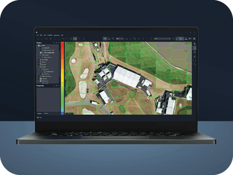
SimActive Correlator3D Mapping with Multi-Camera Payloads
SimActive Enhances 3D Mapping with Multi-Camera Drone Payloads SimActive Inc., a global leader in photogrammetry software development, has announced the integration of its Correlator3D™ product with multi-camera drone payloads to enhance 3D mapping capabilities. This innovative software allows users to import configurations from both oblique and nadir cameras, paving the way for superior 3D…

View On WordPress
0 notes
Text

This week watch Simaction Rxn Live, see all new content. With our new audience, expansion of viewers, and new subscribers we are proud to present our very own Monica Bailey, a new mom, member of super moms and cultural activist. Monica shares her experience of being a new mom in her 40's. #sims4 #sim4content #sims4gameplay #simactionrx #simactionreaction #monicabailey #sims4plopsy Visit the Gameroom, follow us on all socials, like, commment, subscribe, turn on post notifications for more videos including custom content. https://bit.ly/the-gameroom
0 notes
Text
How to Merge LiDAR with Imagery
LiDAR sensors mounted on aircrafts or drones are becoming widely used for mapping. And they are often perceived as a competing technology with standard cameras. It is quite the opposite as they in fact complement each other by capturing data of different nature. Merged together, they actually lead to great advantages for carrying information about the terrain. While LiDAR describes the topography at a high resolution, imagery captures the appearance of ground features. Thus, to integrate these two sources of information usually means using the images to colorize the LiDAR point cloud. It can also imply using the LiDAR as elevation data to generate orthophotos.
The main challenge in integrating LiDAR with imagery is to achieve an accurate co-registration. In other words, both datasets must be perfectly aligned together. The traditional approach is to use ground control points (GCPs) to ensure absolute accuracy separately in both datasets. When subsequent fusion is done, then alignment of the same ground features is accomplished. A major drawback in that method is that the GCPs must be manually tagged twice i.e., in the LiDAR and then in the imagery.
A significantly more efficient method removes the need to control the imagery with GCPs. Instead, the LiDAR data is directly used as a reference and the imagery is automatically registered through bundle adjustment. Tie points are first created by matching corresponding spatial features from the imagery to the LiDAR intensity map. Overall, that new approach allows to quickly combine LiDAR with data from camera systems and produce high-quality outputs.
www.simactive.com
#photogrammetry#mapping#geospatial#mappingdrone#dronedata#surveydrone#uav#uas#lidar#lidar sensors#aerialmapping#simactive
1 note
·
View note
Photo

Please share to all other social media https://onlinerdservice.com Fill up form or details WhatsApp 9810800859 Best deal for everyone #morpho #biomatric #rdserviceonline #onlinerdservice #morpho1300 #idemia #idemiamorpho #csc #simactication #aadharcard #bank #payment #onlinebusiness (at Ludhiana Smart City) https://www.instagram.com/p/CAWrcEBjIFX/?igshid=1ldv9dl6zgvu1
#morpho#biomatric#rdserviceonline#onlinerdservice#morpho1300#idemia#idemiamorpho#csc#simactication#aadharcard#bank#payment#onlinebusiness
0 notes
Text
SimActive Unveils New Licensing Options
SimActive Unveils New Licensing Options
SimActive Inc., a world-leading developer of photogrammetry software, is pleased to offer new Correlator3D™ license options for medium format cameras and satellite sensors. Users who only require to process such data can now benefit from industry-leading software, at a lower price.
The new medium format license supports image formats up to 100 megapixels. For the satellite sensor option, any data…
View On WordPress
0 notes
Text
Satellite Photogrammetry Software Market – Global Industry Trends and Forecast to 2028
Companies desiring an efficient business growth should adopt market research report like Global Satellite Photogrammetry Software Market which seems to be very imperative in this rapidly changing marketplace. While formulating this market report, absolute industry insight, talent solutions, practical solutions and use of technology are merged together very well to advance user experience. The business report brings to notice many points regarding Satellite Photogrammetry Software industry and market. These are mainly explained with respect to market definition, market segmentation, competitive analysis, and research methodology as major topics of the consistent Satellite Photogrammetry Software report. It also gives details about market drivers and market restraints which aids businesses in guessing about reducing or increasing the production of specific product.
A thorough market study and investigation of trends in consumer and supply chain dynamics covered in the wide-reaching Satellite Photogrammetry Software market report helps businesses draw the strategies about sales, marketing, and promotion. Besides, market research performed in this industry report puts a light on the challenges, market structures, opportunities, driving forces, and competitive landscape for the business. It assists in obtaining an extreme sense of evolving industry movements before competitors. If businesses are willing to gain competitive advantage in this swiftly transforming marketplace, then opting for such market research report is highly suggested as it gives a lot of benefits for a thriving business.
Get Exclusive Sample of This Premium Report @ https://www.databridgemarketresearch.com/request-a-sample/?dbmr=global-satellite-photogrammetry-software-market
Our research and insights help our clients in identifying compatible business partners.
The assessment provides a 360° view and insights, outlining the key outcomes of the industry, current scenario witnesses a slowdown and study aims to unique strategies followed by key players. These insights also help the business decision-makers to formulate better business plans and make informed decisions for improved profitability. In addition, the study helps venture or private players in understanding the companies more precisely to make better informed decisions
Global Satellite Photogrammetry Software Market: Competitive Analysis
This report has enlisted the top suppliers and their cost structures, SLA terms, best selection criteria, and negotiation strategies. The competitive analysis helps the vendor to define an alignment or fit between their capabilities and opportunities for future growth prospects.
The report deeply explores the recent significant developments by the leading vendors and innovation profiles in the Global Satellite Photogrammetry Software Market including
Pix4D SA, 3Dflow SR, Agisoft, Capturing Reality s.r.o., NUBIGON Inc., Linearis3D GmbH & Co.KG, Menci software SRL, Photometrix Photogrammetry Software, Skyline Software Systems Inc., Racurs, SimActive Inc., ICAROS, Magnasoft., DroneDeploy, PhotoModeler Technologies, Esri International LLC, Autodesk, Inc., Trimble Inc. and Hexagon AB, Vexcel Imaging GmbH, nFrames, and REDcatch GmbH, among other domestic and global players..
This report also comprises of strategic profiling of key players in the market, systematic analysis of their core competencies, and draws a competitive landscape for the market. This research study lends a hand to the purchaser in comprehending the various drivers and restraints with their effects on the market during the forecast period. The report has been prepared based on the market type, size of the organization, availability on-premises and the end-users’ organization type. Satellite Photogrammetry Software report puts across the idea of high level analysis of major market segments and identification of opportunities.
Read Detailed Index of Full Research Study @ https://www.databridgemarketresearch.com/reports/global-satellite-photogrammetry-software-market
An exceptional Satellite Photogrammetry Software market research report can be structured well with the blend of top attributes such as highest level of spirit, practical solutions, committed research and analysis, innovation, talent solutions, integrated approaches, most up-to-date technology and dedication. Further, strategic planning supports in improving and enhancing the products with respect to customer’s preferences and inclinations. The report comprises of all the market shares and approaches of the major competitors or the key players in this industry. Moreover, this market report also brings into the focus various strategies that have been used by other key players of the market or this industry.
Major Regions:
Geographically, this report split into several key regions, with sales (MT), Revenue (Million USD), market share, and growth rate for these regions, covering
**North America (United States, Canada and Mexico)
**Europe (Germany, France, United Kingdom, Russia, Italy, and Rest of Europe)
**Asia-Pacific (China, Japan, Korea, India, Southeast Asia, and Australia)
**South America (Brazil, Argentina, Colombia, and Rest of South America)
**Middle East & Africa (Saudi Arabia, UAE, Egypt, South Africa, and Rest of Middle East & Africa)
What Are The Market Factors Explained in the Report?
Key Strategic Developments: The study includes the major strategic developments of the market, comprising R&D, new product launch, M&A, agreements, partnerships, collaborations, joint ventures, and regional growth of the key competitors functioning in the market on a global and regional scale.
Key Market Features: The report analyzed key market features, comprising price, revenue, capacity, supply/demand, capacity utilization rate, gross, production, production rate, market share, consumption, import/export, cost, CAGR, and gross margin. Besides, the report also offers a comprehensive study of the key market dynamics and their latest trends, along with relevant market segments and sub-segments.
Analytical Tools: The Global Satellite Photogrammetry Software Market report includes the accurately studied and analyzed data of the key industry players and their scope in the market by means of several analytical tools. The analytical tools such as Porter’s five forces analysis, feasibility study, and ROI analysis have been used to analyze the growth of the key players functioning in the market.
Some Major Points in TOC:
Chapter 1. Report Overview
Chapter 2. Global Growth Trends
Chapter 3. Market Share by Key Players
Chapter 4. Breakdown Data by Type and Application
Chapter 5. Market by End Users/Application
Chapter 6. COVID-19 Outbreak: Satellite Photogrammetry Software Industry Impact
Chapter 7. Opportunity Analysis in Covid-19 Crisis
Chapter 8. Market Driving Force
And Many More…
Check The Complete Table of Content @ https://www.databridgemarketresearch.com/toc/?dbmr=global-satellite-photogrammetry-software-market
Satellite Photogrammetry Software Market: Key Highlights
CAGR of the market during the forecast period.
Detailed information on factors that will assist market growth.
Estimation of market size and its contribution to the parent market
Predictions on upcoming trends and changes in consumer behaviour
Analysis of the market’s competitive landscape and detailed information on vendors
Comprehensive details of factors that will challenge the growth of market vendors
Reasons for Buying this Report
**This Satellite Photogrammetry Software report provides pin-point analysis for changing competitive dynamics
**It provides a forward looking perspective on different factors driving or restraining Satellite Photogrammetry Software market growth
**It provides a six-year forecast assessed on the basis of how the Satellite Photogrammetry Software market is predicted to grow
**It helps in understanding the key product segments and their future
**It provides pin point analysis of changing competition dynamics and keeps you ahead of competitors
**It helps in making informed business decisions by having complete insights of Satellite Photogrammetry Software market and by making in-depth analysis of market segments
Thanks for reading this article you can also get individual chapter wise section or region wise report version like North America, Europe, MEA or Asia Pacific.
Looking for provoking fruitful enterprise relationships with you!
About Data Bridge Market Research, Private Ltd
Data Bridge Market Research Pvt Ltd is a multinational management consulting firm with offices in India and Canada. As an innovative and neoteric market analysis and advisory company with unmatched durability level and advanced approaches. We are committed to uncover the best consumer prospects and to foster useful knowledge for your company to succeed in the market.
Data Bridge Market Research is a result of sheer wisdom and practice that was conceived and built-in Pune in the year 2015. The company came into existence from the healthcare department with far fewer employees intending to cover the whole market while providing the best class analysis. Later, the company widened its departments, as well as expands their reach by opening a new office in Gurugram location in the year 2018, where a team of highly qualified personnel joins hands for the growth of the company. “Even in the tough times of COVID-19 where the Virus slowed down everything around the world, the dedicated Team of Data Bridge Market Research worked round the clock to provide quality and support to our client base, which also tells about the excellence in our sleeve.”
Contact Us
US: +1 888 387 2818
UK: +44 208 089 1725
Hong Kong: +852 8192 7475
Email – [email protected]
0 notes
Text
3D Photogrammetry Software Market Professional Survey Report 2021-2030
The 3D Photogrammetry Software Report gives expert information on market status, future figure forecast, development opportunities, and vital participants dependent on an exhaustive examination measure. Perusers hoping to distinguish viewpoints, for example, market drivers, restrictions, shortcomings, anddangers can get all the ideal data here, alongside supporting figures and realities. The Global 3D Photogrammetry Software Market 2021 Set for Rapid Growth to Reach around USD in Billion by 2030” report serves with all-inclusive, deeply-effective, and completely explained the information in a well-organized custom, based on actual facts, about the 3D Photogrammetry Software Market. The report offers protective and organized management along with highlights the summary of the global 3D Photogrammetry Software market along with classifications and market chain structures. It also highlights authorized statistics of the global 3D Photogrammetry Software market.
The 3D Photogrammetry Software report gives a total investigation of the worldwide market size, Market Classification, Geographic Scope on both local and national level, section development, piece of the overall industry, 3D Photogrammetry Software Market Estimation, Barriers/Challenges, serious scene, deals examination, the effect of homegrown and worldwide market players, esteem chain streamlining, exchange guidelines, ongoing turns of events, Business Overview, SWOT examination, key market development examination, item dispatches, and mechanical advancements.
Market Overview
Industrial 3D Photogrammetry Software Market- Segmentation and Forecast, 2021-2030 report provides readers with a comprehensive outlook of the global Industrial 3D Photogrammetry Software market, to precisely gauge its futuristic development. It assesses the Industrial 3D Photogrammetry Software industry on the historical and current scenario, and also includes a forecast for 2021 through to 2030. The 3D Photogrammetry Software market report is intended to help key partners improve on business choices, comparing to the Industrial 3D Photogrammetry Software market with the assistance of key discoveries and experiences given on the drivers, restrictions, risks, and opportunities expected to affect the potassium formate market during the hypothesis time frame.
Get a Sample PDF of The Report: https://market.biz/report/global-3d-photogrammetry-software-market-gm/#requestforsample
3D Photogrammetry Software Market Top Trending Companies :
Hexagon Trimble Pix4D Autodesk BAE Systems Bentley Systems Suprevision GreenValley International PhotoModeler Technologies Geodetic PMS Photo Mess Systeme AG Datumate Ltd. SimActive Skyline Software Systems Agisoft LLC Drones Made Easy 3Dflow Capturing Reality
3D Photogrammetry Software Market Top Types :
Windows OS Linux OS
3D Photogrammetry Software Market Top Applications:
Culture Heritage and Museum Films and Games 3D Printing, Drones and Robots
3D Photogrammetry Software Market Top Regions:
North America Europe Asia Pacific Latin America The Middle East and Africa
Regional Analysis :
The 3D Photogrammetry Software market study covers every one of the angles beginning from every region, thinking about the certain confirmation of basic market, similar to sections and probabilities of entrance into the market and improvements. The report contains a progressive assessment of the Industrial 3D Photogrammetry Softwaremarket, kept up by the areas. The report covers North America, South America, Europe, Asia Pacific ( APAC), Africa, and the Middle East with their exploration dependent on the provincial just as a public level assessment of the market..
Reports Include:
Qualitative Analysis
Influence Factors
Market Potential
Market Risks and Opportunities
Industry Trends
Geographical Features
Government Policies
To Make an Enquiry On The Report @ https://market.biz/report/global-3d-photogrammetry-software-market-gm/#inquiry
Key Questions Answered In This 3D Photogrammetry Software Market Report.
1. What amount of income will the 3D Photogrammetry Software Market produce before the finish of the figure time frame?
2. Which market section is required to have the most extreme portion of the pie by 2030?
3. What are the affecting components and their effect on the 3D Photogrammetry Software market?
4. What regions are presently contributing the most extreme portion of the general 3D Photogrammetry Software market?
5. What pointers are probably going to stimulate the market?
6. What are the primary procedures of the significant parts in the 3D Photogrammetry Software market to extend their geographic presence?
7. What are the fundamental advances of the?
8. How do administrative norms influence the market?
You Can Buy This Report From Here -https://market.biz/checkout/?reportId=573460&type=Single%20User
Contact Us:
420 Lexington Avenue Suite 300
New York City, NY 10170, United States
USA/Canada Tel No:+1(857)4450045, +91 9130855334
Email: [email protected]
0 notes
Text
Drone Mapping in Construction: SimActive's Correlator 3D
Drone Mapping in Construction: SimActive’s Correlator 3D
Drone mapping in construction can provide construction firms with the data they need to make profitable decisions. Chasco Constructors started in Round Rock, TX as a 4-man shop: but today, Chasco is an award winning, full service commercial construction company with over 300 employees. They’re using cutting edge technology, including drones and mapping, to monitor construction over a more than…

View On WordPress
0 notes
Photo

Please share to all other social media https://onlinerdservice.com Fill up form or details WhatsApp 9810800859 Best deal for everyone #morpho #biomatric #rdserviceonline #onlinerdservice #morpho1300 #idemia #idemiamorpho #csc #simactication #aadharcard #bank #payment #onlinebusiness (at Kurnool) https://www.instagram.com/p/CAWrUxOjalR/?igshid=15ftq2yec1g0
#morpho#biomatric#rdserviceonline#onlinerdservice#morpho1300#idemia#idemiamorpho#csc#simactication#aadharcard#bank#payment#onlinebusiness
0 notes
Photo

Drone Mapping is Getting Bigger and Better: SimActive's Philippe Simard Talks Industry Trends - DRONELIFE Exclusive: Canadian drone mapping platform SimActive's Philippe Simard discusses industry trends, new sensors and new software. https://dronelife.com/2020/04/03/drone-mapping-is-getting-bigger-and-better-simactives-philippe-simard-talks-industry-trends/ https://www.instagram.com/p/B-k9NqIlmla/?igshid=fpk2v7uy6c4c
0 notes
Text
Global Photogrammetry Software Market Trends, Strong Application Scope, Key Players, Growth Overview and Forecast by 2026
Global Photogrammetry Software Market is set to witness a stable CAGR in the forecast period of 2019-2026. Increase in demand for photogrammetry is the major factor for the growth of this market.
Major Market Competitors/Players
Few of the major competitors currently working in photogrammetry software market are Pix4D SA, Agisoft, Autodesk Inc., Capturing Reality s.r.o., Bentley Systems, Incorporated, PhotoModeler Technologies, Photometrix Photogrammetry Software, Intel Corporation, Skyline Software Systems Inc., DroneDeploy, SimActive Inc.

A FREE sample of this report is available upon request @ https://www.databridgemarketresearch.com/request-a-sample/?dbmr=global-photogrammetry-software-market
Photogrammetry is a science which is used to measure the features of the photographs to get the exact position of surface points. The main aim of this photogrammetry is to get the relationship between the images and object. Rising availability of the aerial drones is the major factor which is fuelling the growth of this market.
Competitive Analysis
Global photogrammetry software market is highly fragmented and the major players have used various strategies such as new product launches, expansions, agreements, joint ventures, partnerships, acquisitions, and others to increase their footprints in this market. The report includes market shares of photogrammetry software market for global, Europe, North America, Asia-Pacific and South America.
Market Drivers:
Increasing availability of the affordable aerial drone is another factor driving the market
Affordable price of the photogrammetry software is another factor driving the growth of this market
Market Restraints:
Increasing Omni channel retailing is restraining the growth of this market.
Lack of skilled and trained professionals is another factor restraining market
Speak to Author @ https://www.databridgemarketresearch.com/speak-to-analyst/?dbmr=global-photogrammetry-software-market
Segmentation: Global Photogrammetry Software Market
By Type (3D Reconstruction Software, Based on Images and Video, Based on 3D Scanning),
By Applications (Culture Heritage and Museum, Films & Games, 3D Printing, Drones and Robots, Others)
By Geography (North America, South America, Europe, Asia-Pacific, Middle East and Africa)
Key Insights in the report:
Complete and distinct analysis of the market drivers and restraints
Key market players involved in this industry
Detailed analysis of the market segmentation
Competitive analysis of the key players involved
Browse full report @ https://www.databridgemarketresearch.com/reports/global-photogrammetry-software-market
About Us:
Data Bridge Market Research set forth itself as an unconventional and neoteric Market research and consulting firm with unparalleled level of resilience and integrated approaches. We are determined to unearth the best market opportunities and foster efficient information for your business to thrive in the market.
Contact:
Data Bridge Market Research
Tel: +1-888-387-2818
Email: [email protected]
Related Reports:
Global Valve Positioners Market
#Photogrammetry Software Market#Photogrammetry Software#Photogrammetry Software Market Trends#Photogrammetry Software Market Industry#Photogrammetry Software Market News#Photogrammetry Software Market Research#Photogrammetry Software Market Analysis
0 notes
Text
Global Photogrammetry Software Market Set to Grow at Healthy CAGR forecast by 2026 with Top Key players like Pix4D SA, Agisoft, Autodesk Inc.,Capturing Reality s.r.o., Bentley Systems
Global Photogrammetry Software Market is set to witness a stable CAGR in the forecast period of 2019-2026. Increase in demand for photogrammetry is the major factor for the growth of this market.
Major Market Competitors/Players
Few of the major competitors currently working in photogrammetry software market are Pix4D SA, Agisoft, Autodesk Inc., Capturing Reality s.r.o., Bentley Systems, Incorporated, PhotoModeler Technologies, Photometrix Photogrammetry Software, Intel Corporation, Skyline Software Systems Inc., DroneDeploy, SimActive Inc.

A FREE sample of this report is available upon request @ https://www.databridgemarketresearch.com/request-a-sample/?dbmr=global-photogrammetry-software-market
Photogrammetry is a science which is used to measure the features of the photographs to get the exact position of surface points. The main aim of this photogrammetry is to get the relationship between the images and object. Rising availability of the aerial drones is the major factor which is fuelling the growth of this market.
Competitive Analysis
Global photogrammetry software market is highly fragmented and the major players have used various strategies such as new product launches, expansions, agreements, joint ventures, partnerships, acquisitions, and others to increase their footprints in this market. The report includes market shares of photogrammetry software market for global, Europe, North America, Asia-Pacific and South America.
Market Drivers:
Increasing availability of the affordable aerial drone is another factor driving the market
Affordable price of the photogrammetry software is another factor driving the growth of this market
Market Restraints:
Increasing Omni channel retailing is restraining the growth of this market.
Lack of skilled and trained professionals is another factor restraining market
Speak to Author @ https://www.databridgemarketresearch.com/speak-to-analyst/?dbmr=global-photogrammetry-software-market
Segmentation: Global Photogrammetry Software Market
By Type (3D Reconstruction Software, Based on Images and Video, Based on 3D Scanning),
By Applications (Culture Heritage and Museum, Films & Games, 3D Printing, Drones and Robots, Others)
By Geography (North America, South America, Europe, Asia-Pacific, Middle East and Africa)
Key Insights in the report:
Complete and distinct analysis of the market drivers and restraints
Key market players involved in this industry
Detailed analysis of the market segmentation
Competitive analysis of the key players involved
Browse full report @ https://www.databridgemarketresearch.com/reports/global-photogrammetry-software-market
About Us:
Data Bridge Market Research set forth itself as an unconventional and neoteric Market research and consulting firm with unparalleled level of resilience and integrated approaches. We are determined to unearth the best market opportunities and foster efficient information for your business to thrive in the market.
Contact:
Data Bridge Market Research
Tel: +1-888-387-2818
Email: [email protected]
Related Reports:
Global Valve Positioners Market
#Photogrammetry Software Market#Photogrammetry Software#Photogrammetry Software Market Trends#Photogrammetry Software Market Industry#Photogrammetry Software Market News#Photogrammetry Software Market Research#Photogrammetry Software Market Analysis#Photogrammetry Software Market Size#Photogrammetry Software Market Share
0 notes
Text
Going to Commercial UAV Expo in Vegas? Check out these Booths, Speakers and Sponsors
Commercial UAV Expo in Las Vegas next week looks to be one of the best drone events of the year – where attendees are guaranteed to meet current and potential friends, sponsors, clients, and partners. The event is being held at The Westgate Resort, Las Vegas, USA from October 28 – 30th
While you’re there, stop by these booths to meet some of DRONELIFE’s friends, partners and sponsors that you may have read about here. (Please confirm the dates and times of the sessions as these are subject to change and we don’t want you to go to the wrong place.). And be sure to say hi to Miriam, our Editor-in-Chief, who will be covering the show!
CompTIA: Booth 233
CompTIA is a leading voice and advocate for the $5 trillion global information technology ecosystem; and the more than 50 million industry and tech professionals who design, implement, manage, and safeguard the technology that powers the world’s economy. Through education, training, certifications, advocacy, philanthropy, and market research, CompTIA is the hub for advancing the tech industry and its workforce. https://www.comptia.org/
DroneDeploy: Booth 833
DroneDeploy is the leading cloud software platform for commercial drones, and is making the power of aerial data accessible and productive for everyone. Trusted by leading brands globally, DroneDeploy is transforming the way businesses leverage drones and aerial data across industries, including agriculture, construction, mining, inspection and surveying. Simple by design, DroneDeploy enables professional-grade imagery and analysis, 3D modeling and more from any drone on any device.
In addition, CEO Mike Winn will be on the panel for UAS Insights and Strategies for Success in the Current Marketplace on Tuesday Oct. 29th from 9:00 to 10:45 am in Pavilion 1-3. (see more on Mike below).
Gremsy: Booth 1031
Established in 2011, Gremsy is a leading global brand of the camera stabilizer. Since its establishment, Gremsy has focused on R&D to release high-grade quality products like Gremsy T3, Gremsy S1, and Pixy, …to meet rigorous demands not only for commercial uses but also for enterprise solutions.
Combined with engineers with over 8-year expertise in gimbal designing and with great passion for pushing the limit to be a crucial component of the drone systems, Gremsy continues launching new compact gimbals to carry different sensors.
Besides presenting the latest gimbals at this Commercial UAV show, Gremsy team is excited to discuss with valued clients for their customized gimbals projects.
Check out their new gimbal, the PixyU , that is designed to work with a number of different air frames.
FLIR Systems: Booth 925
FLIR Systems, Inc. is a global leader in the design and manufacture of innovative, high-performance digital cameras for industrial, medical and life science, traffic, biometric, GIS, and people counting applications.
FLIR Systems, Inc. designs, develops, manufactures, markets, and distributes technologies that enhance perception and awareness. We bring innovative sensing solutions into daily life through our thermal imaging systems, visible-light imaging systems, locator systems, measurement and diagnostic systems, and advanced threat detection systems. Our products improve the way people interact with the world around them, enhance public safety and well-being, increase energy efficiency, and enable healthy and entertained communities.
Randall Warnas who runs FLIR global drone business is speaking at the Energy – Vertical Breakout Session on Tuesday October 29th from 2:00 to 3:30 pm in Pavilion 3. (see more on Randall below).
They recently announced the FLIR Muve C360 which helps detect the presence of gas.
Pix4D: Booth 431
Pix4D is a dynamic and rapidly expanding software company with headquarters in Lausanne, Switzerland, and local offices in San Francisco, Shanghai and Berlin. The company develops a line of end-to-end mapping solutions which convert images into georeferenced maps and models. Using advanced algorithms based on computer vision and photogrammetry, Pix4D offers survey-grade accuracy, as well as a unique bundle of desktop and cloud processing.
SimActive: Booth 310
SimActive is the developer of Correlator3D

software, a patented end-to-end photogrammetry solution for the generation of high-quality geospatial data from satellite and aerial imagery, including UAVs. Correlator3D
performs aerial triangulation (AT) and produces dense digital surface models (DSM), digital terrain models (DTM), point clouds, orthomosaics and vectorized 3D features. Powered by GPU technology and multi-core CPUs, Correlator3D
ensures matchless processing speed to support rapid production of large datasets. SimActive has been selling Correlator3D
to leading mapping firms and government organizations around the world, offering cutting-edge photogrammetry software backed by exceptional customer support. For more information, visit www.simactive.com.
Speakers we think are worth seeing (some are partners, others just our industry heroes):
Dyan Gibbons, CEO Trumbull Unmanned: Tuesday October 29 from 4:30-5:45 pm Conference Room 12-14
Dyan attended the Air Force Academy, where she was a member of the Air Force Parachute team and learned to fly. After studying engineering, she served as an Acquisitions Officer. While managing cruise missiles, a type of unmanned aircraft, she earned her MBA. Dyan then supported Air Force One and Global Hawk UAS engineering and logistics. Her PhD research in UAS/drones, RFID, wireless systems, computer vision and the promotion of hydrocarbon sequestration from a UAV led Dyan to the energy sector and being selected as an SPE Distinguished Lecturer (2015-2016). (See our profile of Dyan here to be inspired.)
David Hose, CEO AirMap:
David Hose is a seasoned technology leader and entrepreneur. Prior to joining the AirMap team, David was the Interim CEO of Rhapsody, International; Chief Development Officer and SVP of Openwave Systems; and founder and CEO of Signalsoft, a pioneer in the development of location-based services for mobile phones. David has more than 35 years of experience in technology, serving as founder, CEO, investor, board member, and advisor for more than 40 companies over the course of his career. (See a profile of David here.)
Amit Ganjoo, CEO Anra Technologies: Amit is speaking at both the Drone Industries Visionary and the UAS Traffic Management (UTM) Updates and Progress.
Amit Ganjoo is a serial entrepreneur and the Founder and CEO of ANRA Technologies, an Award Winning UTM Software Company headquartered in Washington, DC with global operations. Amit has over 20 years of aviation, telecom and wireless experience in both the federal and the commercial space. He is an engineer, a licensed pilot, following a lifelong passion in aviation and builds experimental aircraft. He was the Director of Engineering at Ericsson Federal, providing telecom solutions to Federal Government, where he was the recipient of the Athena Award. Deployed as part of the Expeditionary Strike Group, he was chief system architect for Navy 4G LTE Sea Pilot, delivering a one of a kind turn-key, secure, unmanned airborne/afloat autonomous 4G LTE Network with applications to directly support the war fighter. He architected the first ever approved classified security architecture for 4G LTE in line with NSA Commercial Solutions for Classified (CSfC) framework, approved for operational deployment in DoD in 2012. Amit is an adjunct professor at the George Mason University and shares his passion for engineering by teaching in the School of Engineering and volunteers at a local Maker Space in the D.C. area. (See Amit make the concepts of UTM clear here.)
Marc Kegelaers, CEO Unifly:
High profile, quadri-lingual executive with a formal education in Engineering, Business Administration and Aviation. Started his career in the product management department of a multinational (GTE). Over the years, he has gone through the stages of Product Management, International Sales, Key Account Management, Sales Director, General Manager, Chief Executive and Business Owner in a range of sectors: Network management, IT security, Aviation, Telecommunications.
Richard Lopez, Hansel Phelps Construction: Lopez runs the drone program for Hensel Phelps Construction Co. which has one of the first FAA exemptions with help from Parazero systems.
Richard Lopez is a Virtual Design and Construction Manager with Hensel Phelps Construction Co., an employee-owned company that over the last 80 years has grown to be one of the nation’s most recognized general contractors, serving both public and private clients. Richard leads the implementation of new sUAS technology, software, and advancements at Hensel Phelps to increase efficiency and safety on the jobsite while providing valuable information for forecasting, recordkeeping, and as part of the procurement effort.
Lisa Murray, Group Director – Diversified Communications:
Lisa Murray is the director of a group of technology events and media at Diversified Communications, a global event organizer with a dozen offices across the world operating in a variety of business areas. In her role, Ms. Murray oversees Commercial UAV Expo Americas, Commercial UAV Expo Europe, Commercial UAV News and International Lidar Mapping Forum. These market-leading events and media provide professionals access to the education and technology that help them make the best business decisions and connect vendors with qualified buyers. Vertical markets include Surveying & Mapping; Construction; Infrastructure & Transportation; Energy & Utilities; Mining & Aggregates; Forestry & Agriculture; Law Enforcement, Security and Emergency Response.
Douglas Spotted Eagle, Sundance Media:
Douglas Spotted Eagle is a giant in the video and audio industries, having received Grammy, Emmy, DuPont, Peabody, and many other awards. Douglas is a primary instructor and industry consultant for Sundance Media Group, Inc. and VASST, authoring several books and DVDs and serving as an advisor and guide for videographers, software manufacturers and broadcasters. Douglas is a well-known musician and a world-travelled speaker/instructor. Douglas now focuses his energy and experience within the UAV/sUAS industry. Skydiving since 2006 and instructing UAS since 2012, Douglas is an accomplished aerial photographer who thrives in the adrenaline-filled world of fast-action videography. Appointed as a Safety and Training Advisor in the aviation world, he is a risk management/mitigation subject matter expert. Douglas is an audio and imaging pro with numerous awards for his productions; with an intimate knowledge of the FAA FARs and FSIMs, Douglas’ vision is to incorporate his years of imaging and aviation experience into best-practices for everything drone/UAV/UAS. Douglas is a frequent (and dynamic!) speaker and consults on UAV cinematography, commercial and infrastructural UAV applications, UAV risk management, night UAV flight, aerial security systems, and 107 training to ensure pilots clearly understand the FAA laws.
Randall Warnas, FLIR:
Randall is speaking at the Energy – Vertical Breakout Session on Tuesday October 29th from 2:00 to 3:30 pm in Pavilion 3.
Randall manages FLIR’s sUAS business globally, and has a singularly unique perspective of the drone industry. From pioneering drone retail in 2014, he went on to develop the initial stages and foundation of DJI’s Enterprise business. Now working for FLIR, he has engaged with tens of thousands of end-users in both the consumer and commercial space, helped consult and develop hundreds of business around the use of drones, and has worked with most drone manufacturers, software providers, and industrial service companies. Through interfacing with such a wide variety of participants in the drone space, Randall uses this lens to help grow and promote the industry throughout the world. With aerial thermal imaging being one of the most proven applications of drones in the commercial space, his exposure to a variety of use-cases allows him to evaluate and validate potential opportunities with this technology.
Mike Winn, CEO DroneDeploy: Co-Founder and CEO of DroneDeploy will be on the panel for UAS Insights and Strategies for Success in the Current Marketplace.
Mike Winn is the co-founder and CEO of DroneDeploy, where he is responsible for overall strategic direction, management and growth. Winn completed his undergraduate degree in Economics and Maths at Rhodes University. Before starting DroneDeploy, he held sales and technical positions at Google and co-founded Zoomatelo, a web-service that facilitated carpooling in large organizations and communities through closed social networks. In his spare time, you can find him reading or flying RC helicopters and drones.
Gretchen West, CEO Schiebel Aircraft:
Gretchen West is the new CEO of Schiebel Aircraft. Gretchen took the top spot at Schiebel this year, following her time at law firm Hogan Lovells as a Senior Advisor for Innovation and Technology, during which she co-founded drone advocacy group, Commercial Drone Alliance. (See our profile of Gretchen here.)
Source
قالب وردپرس
The post Going to Commercial UAV Expo in Vegas? Check out these Booths, Speakers and Sponsors appeared first on Drone Magazine.
0 notes
Text
Colorized point clouds and more Simactive's new features
Colorized point clouds and more Simactive’s new features
Canadian mapping platform SimActive has added some significant new capabilities this year, including colorized point clouds and reflective calibration. CEO Philippe Simard explains what these features are – and how clients are using them. SimActive releases new features regularly. “With our user base growing exponentially, we are constantly monitoring how our software is being used and how it…

View On WordPress
0 notes