#skunkbush
Explore tagged Tumblr posts
Visit Tumblr Blog
Explore Tumblr blogs with no restrictions, modern design and the best experience.
Last Seen Tumblr Blogs


Fun Fact
The most popular pages on Tumblr are about Minecraft, GIFs, and David J. Peterson.
Text
Water
The burning sensation is fierce—the leaves and flowers of what I thought were Box Elders and Skunkbush caress against my exposed ankles before I even realized. Tingling spreads up my calves, the ivy cold and numbing. I stood at the edge of the small stream of running water. Unremarkable. The water, more of a trickle than a stream, winds through patchwork of pebbles and occasional boulders. Parallel to the dirt path. I am a visitor to Shaganappi Park. It is 3 kilometers to where I'm siting right now.
With each passing minute, the pain grows. My breathing grows shallow. The gully is an ancient mirror, a reflection disturbed by the flutter of a Magpie's wing or the dropping of a dead autumn leaf. There have been Blackfoot and Stoney Nakoda here—too long ago to be important, now. Every body of water, I pause to think, no matter how minor.
There is a painful translucence. An invisibility, the only thing you're really seeing is the light reflecting, like a hollow mimicry of a personality, a person clinging onto anything nearby.
My vision blurs momentarily, the poison seeping, testing me and my resolve. Around the waters, the land speaks in muted tones, greens turned blonde, the rotten brown of flora carcasses, tall grasses bending.
Across the road, in the recovery garden of a school, there is a large medicine wheel made of stone. Manufactured by settlers in construction outfits with equipment too heavy to look at. Workers who live in neighbourhoods where the annoying missionary going door-to-door, selling leather umbrellas called Bibles. The four quadrants of the wheel: The yellow, the red, the white, the black. Turning a more vivid shade during rainfall.
White knuckles clutch my chest, the burning a deep-seated fire, every heartbeat an uneven drum, an uncertain rhythm. Here and there, the sun's rays pierce the water's surface, revealing the depths beneath: a complex ecosystem of tiny organisms, desperate bacteria, darting insects, and the glint of a submerged coin's surface.
Our bodies, just like the earth, are composed mostly of fluid. Spit and blood, phlem and marrow, the nourishing. As the rash continues to climb, becoming a relentless prick, I wonder if the water in my body is reacting, trying to dilute the poison, attempting to keep me balanced, alive. Murky and muddy, floating and drifting, churning.
All there is now, though is a lukewarm dry, a thirst. A throat of barbed-wire, joints aching and radiating, politely asking me to give up. The weight of my water-laden body anchors me to the earth, and yet, ready to evaporate into the gaping maw called sky above.
The water of the stream stands, both still and alive, a mirror. The Maple Leaf Convenience Store is nearby, maybe with First Aid, maybe with a cashier waiting to fall in love. I know my spirit will one day drift, becoming one with the gentle ripples and whispers of the stream. In this wet cradle, I find rebirth in eternal rest, only moving to dance with water's ebb and flow silently.
0 notes
Text
The Forager's: Skunkbush Profile
The Forager’s: Skunkbush Profile
Rhus trilobata Also, Known As:
Aromatic Sumac
Basketbush
Fragrant Sumac
Ill-scented Sumac
Scented Sumac
Skunkbush
Skunkbush Sumac
Squawbush
Skunkbush (scientific name Rhus trilobata) is a low-growing, bushy shrub belonging to the sumac genus. Also known as sour berry or three-leaf sumac, it grows up to a height of anything between 2 feet and 6 feet. This shrub is found growing in clumps in rocky…
View On WordPress
3 notes
·
View notes
Photo


A preview of Autumn
(c) riverwindphotography, September, 2018
181 notes
·
View notes
Photo

Skunkbush sumac (Rhus trilobata) on Seedskadee National Wildlife Refuge (via USFWS Mountain-Prairie)
The first hint of fall on Seedskadee NWR begins with skunkbush sumac (Rhus trilobata). Its green leaves begin to turn red, yellow, and orange in the first few weeks of September. Other common names include sourberry, skunkbush, polecat bush, stinking sumac, ill-scented sumac, quailbush, basketbush, lemonade sumac, three-lobed sumac, and three-leaved sumac. It has been reported that some Native American Tribes used pliable young stems that were woven with grass stems into durable baskets that would hold water.
On Seedskadee NWR, it only grows where extra water is available along the banks of the Green River. Many species of migratory birds use it to forage, rest, and nest among its branches and mule deer will browse heavily on the young stems.
Photo: Skunkbush sumac on Seedskadee NWR
Tom Koerner/USFWS
#Skunkbush Sumac#Rhus trilobata#Rhus#Anacardioideae#Anacardiaceae#Sapindales#sumac#shrub#foliage#plants#autumn#Seedskadee NWR#Seedskadee National Wildlife Refuge#Wyoming
16 notes
·
View notes
Photo

White Sands Blonde mice and white lizards blend into the background in a desert of milk-white dunes.
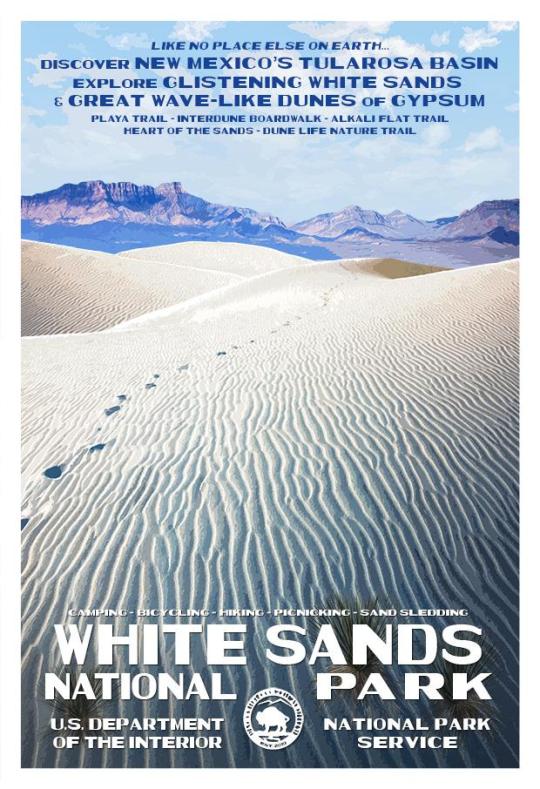
Shimmering white dunes, shaped and contoured by the wind into smoothly rounded crescents, stretch endlessly before the eyes of wanderers in the White Sands. But this is unusual sand – not the usual quartz, but gypsum. White Sands is the world’s most impressive gypsum desert, about 300sq miles (780km2) in extent; it lies in the flat-floored Tularosa Valley in New Mexico, and much of it has been a US National Monument since 1933. No one ever exploited its gypsum; the area was too remote and gypsum was plentiful elsewhere. Gypsum is a white mineral used in cement and plater manufacture, and massive layers of gypsum rock exist in the mountains that surround White Sands. Centuries of erosion by gravity, rain and melting snow have carried rock debris down to Lake Lucero, the lowest part of the basin, where it mixes with water that seeps up from the valley floor. Sun and wind evaporate the water to leave a dry bed of coarse encrusted gypsum that is ground by wind into fine particles. These are blown into dunes that can grow 100ft (30m) high. Slowly the wind shifts the dunes and they migrate north-east, sometimes at a rate of about 20ft (6m) a year. This arid, dazzling landscape below a wide, blue sky and relentless sun evokes the Old West – the Rio Grande is not far away. Mescalero Apaches came here to gather on the alkali flats, and there are still plaster casts of their campfires – the heated gypsum formed plaster of Paris, which was set by rain. Silver City, west of the San Andres Mountains, was the birthplace in 1859 of William H. Bonney, better known as Billy the Kid. Some plants succeed in scratching sustenance from this shifting wilderness. Cottonwood trees thrust defiantly skywards, sometimes with just their heads above a dune. When the dune moves on, they may be left encased in a plaster cast. Similarly, skunkbush (lovely name right?) sumacs sit on stools of hardened gypsum. Soaptree yuccas survive by pushing snake-like stems through the dunes. Their creamy, bell-shaped flowers, known as ‘Candle of the Lord’, are New Mexico’s State flower. Native Americans ate the shoots and flowers made porridge from their seeds. Few large animals venture into the white desert – it offers little food and no shelter from the killing midday heat. Sands pocket gophers thrive because they burrow into the sand away from the heat and Apache pocket mice also shelter in these gopher burrows. Along with three kinds of lizard – particularly the bleached earless lizard – these pocket mice have developed bleached white colouring that camouflages them from predators such as owls and hawks. Unlike the Westerners of old, who braved the heat and the sandstorms on foot or horseback, modern visitors to White Sands can drive through the area along a signposted route. Sandstorms sometimes slow traffic, and drifting dunes may bury the road. ~ JM Image Credit: https://commons.wikimedia.org/wiki/File:White_Sands_National_Monument_-_New_Mexico_-_dawn_in_the_desert_-_(17480401603).jpg More Info: https://www.nps.gov/whsa/index.htm National Park Service, White Sands: We have wrote about this before - see here at http://on.fb.me/1GSVJA7
#white sands#national park#tularosa#valley#new mexico#wildlife#gypsum#erosion#scence#travel#geology#sand#dune#the earth story#ripple
136 notes
·
View notes
Photo

My favorite giant skunkbush sumac, hidden far out in the gypsum dunes of White Sands National Park, NM. . . . . . . . . . . . . #newmexico #landscape #whitesands #nationalpark #alltrails #modernoutdoors #roamearth #rediscovertheearth #ViewBug #earthfocus #TLPicks #OurPlanetDaily #lonelyplanet #lpfanphoto #sonyalpha #usinterior #NewMexicoTrue #nmoutside #nmnomad #instagramersnm #TravelNM #beautiful_newmexico #nmco #FindYourPark #GoParks #Parks101 #nationalparkgeek (at White Sands National Monument) https://www.instagram.com/p/B9P7giwFYeQ/?igshid=16l9q87pp54yf
#newmexico#landscape#whitesands#nationalpark#alltrails#modernoutdoors#roamearth#rediscovertheearth#viewbug#earthfocus#tlpicks#ourplanetdaily#lonelyplanet#lpfanphoto#sonyalpha#usinterior#newmexicotrue#nmoutside#nmnomad#instagramersnm#travelnm#beautiful_newmexico#nmco#findyourpark#goparks#parks101#nationalparkgeek
33 notes
·
View notes
Photo

[Image: The ghostly Wanderer X stands on the surface of a quiet stream, somewhere in the Verde Valley. Its glassy waters flow wild with cottonwoods on its banks, accompanied by skunkbush sumacs and yerba mansa. The reverse of their reflection reveals that this was the site of the reservoir. The dam still rises on the mirrored horizon, and 2105 is still down there, somewhere, drowning under the memory of all that water... ]
◆
iv.
We didn't come here just to mourn. We have reason to celebrate, you and each of us-- look.
Can you see it?
Abandoned ◆ Treasure ◆ Explorations ◆ Decisions ◆ Read the full Natura Humana quest at TWWM! ◆
(crawls back into my hole) @_@
happy to have one more of these quests to my name. It went a little off the rails, but... this is the first I've completed since Firestorm, back when I first joined TWWM, heh.
This one is much more “disjointed”, in part because 2105 is quite literally living in the past and sees things in metaphor and nightmare, and also because I just wanted to let loose and have fun. Narrative clarity fell by the wayside. So, I will include a brief synopsis:
2105 is a spirit living on a river that was dammed, sometime during the turn of the 20th century. Fast forward 100 years, and after much organizing and community effort, the dam has been removed and the river restored. 2105 doesn't realize anything has changed, however. They're so stricken by grief that they are still living as if their world is under water. Enter X, who was present for both the damming and the removal, and who feels a sense of responsibility for it. These pieces are their (perhaps ill-fated) attempt to tell the story of the removal to an incoherent 2105.
2105's story is inspired by my own experiences with river restoration, as well as the story of Fossil Creek. The area still faces a lot of challenges, but this article is a feel-good pick-me-up nonetheless : -9
11 notes
·
View notes
Text
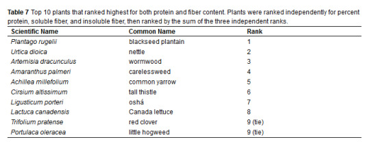
Ethnobiologists research the prairie plants utilized by Indigenous peoples to determine the most nutritious native plants in the Midwest and Great Plains regions: Here’s some data, from 2018, about multiple native plant species and their protein and fiber content.

A few of the most nutritious native plants and Indigenous food sources in the Great Plains:
- Eastern gamagrass (ground hull is highest in total dietary fiber; seeds store for long periods; good forage crop)
- Buffalo gourd (highest protein content)
- blackseed plantain (high fiber content)
- pitseed goosefoot (Chenopodium berlandierir - leaves are high in protein)
- carelessweed (Amaranth palmeri - useful as an easily cooked green, with edible seeds, as well)
- ram’s horn (Proboscidea louisianica - young pods are a common cooked vegetable for Great Plains and Apache people)
- honey mesquite (in the High Plains, its seed-filled pods were consumed widely, and the tree propagates easily)

This study assessed the area inhabited by Indigenous peoples of the “Plains culture region.” [Map of the general Native culture regions of North America, by Wikimedia user Nikater.)

This is an outline of the combined tall-grass prairie of the “Prairie Peninsula” (eastern Iowa, Illinois, Indiana, western Ohio) and the Great Plains. (This is Kuchler’s famous map of “potential natural vegetation,” which basically outlines the extent of native vegetation if left undisturbed by imperialism/colonialism/European influence.)
-
Midwestern / Great Plains native plants with highest percentages of protein:

Midwestern / Great Plains native plants with highest percentages of soluble and insoluble fiber:

Top 10 native plants from Midwest/Great Plains which ranked highest for both protein and fiber content:
Combined protein and fiber content of many edible native plants in the Great Plains:

Abstract:
Traditional foods of indigenous people are a potential untapped source for providing nutritious dietary options in the modern world. The rising popularity of indigenous foods such as amaranth in recent years suggests that these foods can become a popular part of a healthy diet in the United States. Traditional knowledge of indigenous people can form the basis for using wild food resources. This research provides data on 50 plant species common to the central United States that are abundant sources of dietary protein and fiber, and used traditionally by Native American tribes. Many species show promise with high amounts of protein and fiber being found in lamb’s quarters, nettles, grass seeds, and buffalo gourd seeds. These results honor traditional knowledge. In addition, many of these species could be cultivated using techniques similar to those existing for commercial grains and vegetables. Seeds and/or greens of these wild plants could easily be incorporated into the diets of many more people, improving modern diets, and the nutritional quality of food products.
Seeds:
“Twelve of the seventeen species’ seeds tested had total dietary fiber values higher than commonly consumed [non-native plants; grocery store vegetables] species.”
“Buffalo gourd (Cucrbita foetidissima) seeds had the highest protein content, which was higher than any of the commonly consumed species. Soapweed yucca (Yucca glauca) had the second highest protein content ...”
“Twelve of the seventeen species’ seeds tested had total dietary fiber values higher than commonly consumed species. The highest value was found in eastern gamagrass seed, which had nearly double the total dietary fiber of chia (Salvia hispanica) seeds.“
Fruits:
All but two species of fruit tested had higher values of protein than commonly consumed dried fruits, and all but one had substantially higher values of total dietary fiber than commonly consumed species (Table 4). Young green pods of ram’s horn (Proboscidea louisianica) were the top source of protein out of all fruits, followed closely by honey mesquite (Prosopis glandulosa), skunkbush sumac (Rhus trilobata), longleaf groundcherry (Physalis longifolia), and golden currant (Ribes aureum var. villosum). These species contained nearly or over double the percent protein of all commonly consumed species.
Skunkbush sumac fruits contained the highest total dietary fiber content, all of which was the insoluble form. Honey mesquite pods contained the second highest percentage of total dietary fiber and insoluble fiber. Ram’s horn pods were the top source of soluble fiber, followed by golden currant, honey mesquite, common pawpaw (Asimina triloba), and longleaf groundcherry.
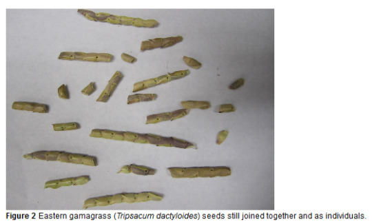
Eastern gamagrass
Eastern gamagrass is a notable species (Figure 2), with a long history as food, and once considered as a possible progenitor of corn (Eubanks 1997), though recent evidence suggests it is not (Matsuoka et al. 2002). It is native to tallgrass prairies of the central United States and into central Mexico. The seeds have an ancient use as food and were found stored in bundles in the remains of Ozark Bluff-dwellers cave habitations (Gilmore 1931), which may be 2,000 years old. However, the seeds are hard to prepare because the hulls are very tough and thick. We ground up both the hull and endosperm for testing, which resulted in our highest amount of total dietary fiber. This plant has been studied by the Land Institute in Salina, Kansas as a possible perennial grain crop (Jackson 2002; Jackson and DeWald 1994). It is an important forage crop and seeds are available through commercial sources. While not nearly as productive as corn, it has seeds about a fourth the size of corn and production techniques have been established as it is harvested mechanically for the native grass seed industry.
Conclusion:
Many of the plants tested contain protein and fiber at amounts superior or comparable to commonly consumed foods. Identification of plant species with novel protein and fiber sources could raise awareness of wild plants and traditional knowledge and cultivation and/or harvest of these plants could become both commercially viable and competitive in the world market. Of particular note is the recognition of indigenous food practices as not only successful, but beneficial to a modern dietary intake. Introducing these indigenous plant foods to the wider public has value beyond simply their appeal as food. Promoting the indigenous origins of the foods acknowledges the subsistence innovations of the Native Americans beyond corn and honors their ancient and traditional knowledge of native foods. It represents another important contribution of Native American culture to the wider world and evidence of their healthier and more sustainable cultural practices. Tribes today may be particularly interested in these plants and how they might be used to improve the health and economic welfare of their Tribal members. For modern use of these plants as foods, future studies on the energy content and economics of cultivation of the plants will be important next steps.
-
Full article available for free.
224 notes
·
View notes
Video
youtube
HICKMAN BRIDGE TRAIL - CAPITOL REEF NATIONAL PARK - UTAH Coordonnées GPS: 38.28870, -111.22773 Stationnement et début du sentier
Sentier de 2,7 km qui se termine par une boucle autour d'un pont naturel. Difficile au début puis modéré par la suite.
Voici différents attraits qui peuvent être observés le long du parcours:
Rivière Fremont
Coordonnées GPS: 38.28825, -111.22581
La rivière Fremont était et reste au cœur de la topographie et de l'histoire humaine préservées dans le parc. L'action érosive du fleuve et de ses affluents se poursuit aujourd'hui, notamment lors des crues. Pendant près de 2000 ans, la rivière a soutenu des communautés agricoles sur les terres arables près de sa confluence avec Sulphur Creek.
Dôme du Capitole
Coordonnées GPS: 38.28896, -111.22535
Juste devant se trouve le Capitol Dome, qui ressemble au bâtiment du Capitole à Washington, DC. L'autre partie du nom de Capitol Reef dérive d'une utilisation régionale courante du terme nautique «récif» pour identifier les crêtes abruptes qui constituent des obstacles au transport.
Fondation Pithouse
Coordonnées GPS: 38.28888, -111.22571
Marchez sur le sentier latéral au nord-est d'environ 30 pas. Vous pouvez identifier les restes d'une fondation de pithouse par l'anneau de rochers noirs. Le peuple préhistorique de Fremont habitait la région de Capitol Reef, s'installant dans des fosses entre 300 et 1400 de notre ère. Le peuple de Fremont a laissé bon nombre de ces sites et d'autres éléments culturels de leur vie ici.
Lavoir
Coordonnées GPS: 38.29083, -111.22980
Vous marchez dans un lavoir, soi-disant parce que l'eau passe par ici pendant les tempêtes. Entre les pluies, le sable agit comme un isolant pour limiter l'évaporation et suffisamment d'humidité sous la surface est retenue pour supporter de grands arbres et arbustes. Près du poteau se trouvent des exemples robustes de pin pinon, de peuplier de Fremont, de skunkbush, de genévrier et d'amélanchier de l'Utah. Les lavages et les canyons étroits sont sujets aux crues soudaines, en particulier lors des orages.
Grenier de Fremont
Coordonnées GPS: 38.29063, -111.23048
Regardez au pied de la falaise au nord. Les restes d'un grenier construit par le peuple Fremont sont nichés dans les couches de la Formation de Kayenta. Ici, ils ont stocké leur nourriture et avaient vue sur leurs récoltes de maïs, de haricots et de courges qu'ils cultivaient dans le sol riche de la plaine inondable en contrebas.
Nels Jonhson Natural Bridge
Coordonnées GPS: 38.29056, -111.23116
Un petit pont naturel en contrebas du sentier témoigne du pouvoir érosif de l'eau. Les eaux de crue, chargées de sable et de cailloux jouant le rôle de gravier, font l'essentiel du travail. L'érosion a élargi les canyons qui ont été creusés par l'écoulement de l'eau. Les petites bosses sur le sentier devant vous sont des accumulations de fer résistantes à l'érosion.
Cavités de solution
Coordonnées GPS: 38.29043, -111.23176
La paroi rocheuse à travers le canyon est parsemée de nombreux trous appelés cavités de solution qui se forment alors que les eaux souterraines légèrement acides dissolvent la calcite qui a cimenté les grains de grès ensemble.
Pont naturel Hickman
Coordonnées GPS: 38.29116, -111.23321
Le pont naturel Hickman se dresse devant. Il mesure 40 m de long et 37 m de haut. Il a été nommé d'après Joseph Hickman, qui était administrateur d'une école locale et législateur de l'Utah. Hickman a été l'un des premiers défenseurs de cette région, qu'il a appelée "Wayne Wonderland".
Formation Kayenta
Coordonnées GPS: 38.29131, -111.23406
C'est un bon endroit pour observer comment le pont naturel s'est formé. La Formation Kayenta est constituée de lits durs alternant avec des couches beaucoup plus molles. Le pont est en grès ferme, tandis qu'à côté du sentier se trouve du schiste rouge friable qui s'effrite facilement.
Pendant les périodes plus humides, l'eau a coulé derrière l'ailette dans laquelle le pont a été coupé et a érodé le schiste mou jusqu'à ce qu'il perce. L'érosion ultérieure a élargi la portée.
Le sentier passe ensuite sous le pont et tourne à gauche pour former une petite boucle qui nous ramène ensuite sur le sentier principal que nous parcourons en sens inverse pour retourner au stationnement.
Si vous désirez obtenir plus d'informations à propos de ce parc, je vous invite à visiter ce site web: https://www.nps.gov/care/index.htm
*********************************************
AUTRES VIDÉOS DE CE ROAD TRIP:
https://www.youtube.com/playlist?list=PLlRroQCNvchsdvRQOTUATm7OU6BabhYIF
ABONNEZ-VOUS ► https://www.youtube.com/c/SouthAngelVideo?sub_confirmation=1
SUIVEZ NOUS :
• BLOGGER ► http://southangelvideo.blogspot.ca/ • INSTAGRAM ► https://www.instagram.com/annestrasbourg/ • FLICKR ► http://www.flickr.com/photos/anne_strasbourg/collections/ • TWITTER ► https://twitter.com/AnneStrasbourg
0 notes
Text
So with the season getting warmer and moving into spring now is the time to start helping the bees by planting flowers and other bee friendly plants! I have created a list of plants that you could plant in the Spring and early Summer. American Plum, American Vetch, Blanket Flower, California Dutchman’s Pipe, California Poppy, Chokecherry, Clasping Coneflower, Daisy Fleabane, Foxglove Bearded Tongue, Golden Currant, Large Penstemon, Lyrate Rockcressm Ohio Spiderwort, Prairie Rose, Prickly Wild Rose,Red Flowering Currant, Rosemary, Sandcherry, Scarlet Gaura, Scarlet Globemallow, Shell-Leaf Penstemon, Skunkbush Sumac, Western Yarrow. Enjoy Planting!
48 notes
·
View notes
Photo
White Sands National Park
White Sands National Park: White Sand National Park: Like No Other Place Else on Earth At White Sand Dunes National Park, great wave-like dunes of gypsum sand engulf 275 square miles of desert and preserves a piece of New Mexico's unique geology. In fact, the gypsum dune field is the largest of its kind on Earth. Gypsum is rarely found as sand because it dissolves in contact with water. But, the isolation and weather patterns of the Tularosa Basin creates a truly unique experience for intrepid park explorers. Visitors can hike, enjoy ranger-led educational programs and even try sand sledding! White Sands was established as a national monument in 1933 and re-designated as a national park in December, 2019. Exploring White Sands National Park by Car Dunes Drive is an eight-mile scenic drive that leads from the visitor center into the heart of the gypsum dunefield. The 16-mile round-trip drive takes approximately 45 minutes. You will want to allow additional time to explore the dunes, take photos, and/or learn about the natural and cultural history of the world's largest gypsum dunefield. Along the road, you will find outdoor exhibits, hiking trails, picnic areas and parking areas. The first five miles of Dunes Drive are paved and the last three miles are a hard-packed gypsum sand road. The road is suitable for cars, motorcycles, recreational vehicles, and buses. Missile Tests and Road Closures From time to time, White Sands Missile Range performs missile tests that may close Highway 70 to traffic. Depending on the nature of the testing, Dunes Drive may also be closed during missile tests for visitor safety. During these times, the visitor center remains open. Visitors are invited to view the museum exhibits, watch the 17-minute orientation film, and peruse the park store and gift shop while Dunes Drive is closed. Weather Weather conditions can change drastically—from sudden downpours to dust storms. The road can be slippery when wet, especially during the winter. It may also be harder to spot frozen water. For your safety, decrease your speed and brake gently to avoid skidding. Dust storms can drastically reduce visibility. Do not drive during a dust storm. Hiking the Dunes There is no better way to experience the unique landscape of White Sands National Park than by venturing out onto any of our five established trails. Explore the dunes and enjoy the silence and solitude of the dunefield with its stunning views of the surrounding mountains. The trails vary in terms of difficulty and scenery. Plan ahead to ensure you have a great and safe hike. Each trail is marked with a specific colored post (i.e., green, blue, orange, or red) and a symbol (i.e., hearts, clubs, spades, or diamonds). You should familiarize yourself with these colors and symbols to help orient yourself to the trail before you start your hike. This information will be critical if you become lost. Interdune Boardwalk The Interdune Boardwalk is fully accessible for people using wheelchairs and strollers. Take an easy 0.4 mile round trip stroll through the dunes and learn about the science, geology, plants, and animals that make White Sands an unequaled natural wonder. The boardwalk is a great place to take a break under the shade canopy, listen for bird calls, observe lizards and enjoy the wildflowers. Playa Trail The Playa Trail is an easy, 0.5 mile round-trip, level trail with outdoor exhibits along the way to help you learn and explore this trail and the characteristics that make it special. On this self-guided trail, you will discover the importance of a playa undergoing constant change. Learn how this change creates habitats for plants and animals. It may be brown, white, filled with water, or have growing crystals. See what the playa looks like today! At the end of the trail, you have the opportunity to travel back in time and see what this area looked like 10,000 years ago and learn about the giants that once roamed this land. Dune Life Nature Trail The Dune Life Nature Trail is a moderate, one-mile self-guided loop hike. Though not difficult, this hike does require hikers to climb two steep dunes with loose sand. Follow the blue trail markers with a club symbol. Meet Katy the Kit Fox and learn about her friends on this family-oriented trail. Look for tracks of the animals that call these dunes their home. Kit foxes, badgers, birds, rodents, and reptiles all live in this area. Backcountry Camping Trail The Backcountry Camping Trail is a moderate, 2-mile round-trip hike. Though backpackers hike the trail most frequently, it is also open to visitors who want a shorter hike through the heart of the dunes. Follow the orange trail markers with a spade symbol into an area of beautifully varied dunes and vegetation. The trail requires hikers to climb over several steep dunes and loose sand. There is no shade, no water, and no toilet facility along this trail. Alkali Flat Trail The Alkali Flat Trail is a strenuous, 5-mile round-trip hike. Follow the red trail markers with a diamond symbol. The Alkali Flat Trail skirts the edge of what is now the final remnant of Lake Otero. This trail is not flat! You will be hiking up and down dunes the entire way. Go only if you are prepared. There is no shade, no water, and no toilet facility along this trail. Native Plant Garden Trail Although White Sands is located in the arid Chihuahuan desert, it is also a place of amazing life and diversity. Learn about some of the native plants of the Chihuahuan desert by taking a walking tour of our native plant garden located in front of the visitor center. The best time for touring the native plant garden is from mid-March through late November. Many plants are dormant during the winter months. Most wildflowers begin blooming around the middle of April. Soaptree yuccas are the star of the spring flowers and typically blooms in late April through May. Some plants may continue to bloom throughout the summer, such as the Colorado four o' clock. Many plants, including the ocotillo, burst into bloom after monsoon rains. Fall colors can begin to appear as early as October and last through November. This is the time when the Rio Grande cottonwood trees begin to turn a beautiful orange and the skunkbush sumac start to turn a vibrant red. Bicycling Bicycling at White Sands is truly a unique experience—nowhere else in the world can you ride a bike on a hard-packed gypsum sand road through the heart of an immense gypsum dunefield! This distinctive experience requires one to be prepared and alert. What kind of bike is best for Dunes Drive? Rangers are frequently asked this question, and the response is, "It depends." The answer typically depends on the condition of the road. Dunes Drive is eight miles one-way. The first four miles are paved, and the rest of the road is hard-packed gypsum sand. Dunes Drive will frequently have a rough "washboard" surface, potholes, and sand drifts. These hazards make riding a bike on Dunes Drive challenging. Experienced riders on mountain and city/beach cruiser bikes with wide tires should be able to handle the varied road conditions and hazards. Road bikes with skinny street tires are not recommended on the sand-portion of Dunes Drive. Sand Sledding Sledding on the beautiful soft sand at White Sands National Park is a popular activity and great fun for children and adults alike. Unlike snow, sand is not slippery and sledding down the face of a dune can take some practice unless you have the correct equipment, know proper techniques and use safety precautions. Waxed plastic snow saucers work best and can be purchased at the park's gift shop. Please call the gift shop at 575-479-1629 before arriving to confirm the availability of sleds. You may also bring your own sleds. Choose a dune with a gently sloping face and a level run-off at the end so that you can come to a halt safely. Be aware of where the dune slope meets the desert floor. While the dune sand is soft, the area at the base of the dune can be very hard, and unintentional injuries are surprisingly common. Make sure the sledding path does not cross the roadway or parking areas and is free from hazards such as vegetation, hard clumps of sand, or other obstructions. Photographing the Dunes With the shifting light, shadows, and truly out-of-this world landscape make White Sands a photographer's paradise. You do not need an expensive camera to capture the beauty of the dunes. Great pictures, however, require the same techniques and way of looking at things that pros have learned. Every day at White Sands National Park will be different. Sometimes there are crystal clear views of the surrounding mountains and sometimes awesome cloud formations that change hues by the minute. The Sacramento Mountains to the east are especially beautiful just after the sun dips below the horizon where they are bathed in a pink afterglow. If you see a good photo, take it. Don't get so wrapped up in all the technical aspects of taking the photo that you miss the opportunity. Go out, have fun, enjoy the dunes and remember "leave footprints and take only pictures." Here are some things to consider: Hike to the top of the tallest dune around and take in the bird's eye view. The tallest dunes are toward the end of Dunes Drive near the Alkali Flat trailhead. Drop to your knees and look up. Yuccas against the sky and the delicacy of dune grasses are especially interesting from a low angle. The patterns left in the sand by grasses and leaves blown by the wind are fascinating. Sometimes you will find the tiny tracks of a darkling beetle just waiting to be recorded, and sometimes you'll find the actual beetle. The interdunal areas are great places to find animal tracks and rugged, gnarly plant growth. Most beginners tend to center objects and include the entire object in the frame. However, you'll end up with a more interesting photo when you shoot slightly off center and occasionally only include half of the object or two-thirds of it in the frame. This results in an unexpected look for the photo and in interesting composition. Placing a plant or rock in the near foreground of your photo will help the viewer see the scale and distance in your photograph. Give the viewer an object which will help them understand size and distance of your intended subject. The most important thing to remember is that the photographs you take are your own view of the subject and you have recorded these images for your own enjoyment.Taking good photographs is a way to record your memories of White Sands and other places you visit and to share those memories with family and friends. A Bit of Trivia White Sands National Park has been featured in a variety of films, including Four Faces West (1948), Hang 'Em High (1968), The Hired Hand (1971), My Name Is Nobody (1973), Bite the Bullett (1975), Young Guns II (1990), King Solomon's Mines (1950), The Man Who Fell to Earth (1976), and Transformers (2007). Click here to see the White Sands National Park poster! https://national-park-posters.com/blogs/national-park-posters/white-sands-national-park?utm_source=rss&utm_medium=Sendible&utm_campaign=RSS
0 notes
Text

March 11, 2019
Oldest Tattoo Kit in North America Uncovered
A Ph.D candidate at Washington State University found the oldest tattoo tool in North America when taking inventory of archaeological materials stored for more than 40 years. It is dated at 2000 years old. This pushes back the earliest evidence of tattoo tools in North America back 1000 years. The tool was from the Basketmaker II culture in the Southwest. No tattoos have been found on human remains in the Southwest and no accounts of its use have been recorded there. Earlier cactus tattoo tools have been found at 1100-1280 CE. There are depictions of tattooing in ancient artwork. The cactus tool that the student found was at a Utah site that is 1000 years older than the known cactus tools. The tool consists of a 3 ½ inch wooden skunkbush sumac handle bound at the end with split yucca leaves and holding two parallel cactus spines, stained black at their tips. The tool was put under an electron microscope, X-ray florescence and energy dispersive ray spectroscopy.
A research report has been published at; Andrew Gillreath-Brown et al, Redefining the age of tattooing in western North America: A 2000-year-old artifact from Utah, Journal of Archaeological Science: Reports (2019). DOI: 10.1016/j.jasrep.2019.02.015
Phys.org has the story here; https://phys.org/news/2019-02-oldest-tattoo-tool-western-north.html#jCp
Mike Ruggeri’s Moundbuilders/Ancient Southwest News on Tumblr http://mikeruggerisancientnorthamerica.tumblr.com
0 notes
Photo
[Image ID: Photo of some branches with red, yellow, and green leaves. Text in the bottom corner says © rivermusic. /End ID]

Skunkbush Sumac (Rhus trilobata) showing off among the shrubbery ;)
riverwindphotography, October 2018
356 notes
·
View notes
Photo

Giant Skunkbush Sumac, White Sands National Monument, NM
I didn’t mention Earth Day yesterday, but anyone who knows me knows how much joy I get from this amazing planet of ours. I live for the days I get to spend under the sun, out in the middle of nowhere, hunting down some crazy rock formation or hiking blindly to a giant tree I see far off on the horizon. Even in a world where most everything has been discovered, I strive to discover these places for myself, to see all these natural treasures with my own eyes. We’re only here for a short time, and the way we treat this planet during that time is paramount to the survival of our species and all species on Earth. I do what I can, I respect the nature around me, and I am forever thankful for every second I get to spend amongst the rocks and plants and little creatures of this world.
57 notes
·
View notes
Text
Los 10 edificios más influyentes de la 20 ª Century - Guía para principiantes a la Arquitectura Contemporánea
tienen estilos arquitectónicos, desde la prehistoria a la post-moderna es una ventana de peso en el pasado para cualquier persona interesada en los orígenes y la naturaleza de las culturas humanas. Los edificios reflejan la naturaleza del tiempo y lugar, conservado en piedra o mármol grabado, más que cualquier otro tipo de artefacto. Por supuesto, la mayoría de la gente está familiarizada con las más grandes obras de la arquitectura medieval antigua y del Renacimiento, aunque pocos se dan cuenta trabajos críticos del siglo pasado que dieron forma a la manera today.It diseño de los arquitectos dice mucho sobre la humanidad de la fascinación años de edad con construcción, son el medio ambiente que 5 de los 7 originales "Maravillas del Mundo" se arquitectónico. Hay muchas obras ahora famoso de la arquitectura desde la prehistoria, de las pirámides de Egipto a los templos mayas. También hay estructuras famosas de la época griega y romana, incluyendo el Partenón, el Panteón y el Coliseo de la gran Roma. Sin embargo, estos son mucho menos influyentes en el camino los edificios se diseñan hoy, cuando algunos importantes obras arquitectónicas del modernismo, el postmodernismo y contemporáneo movimientos deconstructivista. Los siguientes 10 edificios representan obras críticas de cada uno de estos movimientos. Desde cada uno, cada una de estas estructuras a menudo en el campo de la arquitectura y también citó. Mediante el examen de estos edificios a corto, uno puede entender los orígenes de los enfoques modernos para la construcción de design.1) Villa Savoye (Le Corbusier). Esta es quizás la obra más conocida de los famosos arquitectos modernos. Esta casa representa todo lo que Le Corbusier creía que los ideales modernos: fue levantado sobre pilares, se había "abierto" (a no ser de muros de carga y poder, reorganizar), y tenía enormes ventanas, para intercambiar puntos de vista de paisaje. Como contrapunto a esta casa más moderna, pero también es digno de mirar a su notable Notre Dame du Haut - una iglesia que Le Corbusier creía que la arquitectura religiosa ha sido demasiado abstracto, expresivo y adecuado sublime.2) Pabellón de Barcelona demostrado (Mies van der Rohe). Al igual que la Villa Savoye, esta estructura de las columnas de soporte, las paredes y los espacios puede ser configurado para abrir en todas las formas posibles. Era un diseño "completo, incluido el mobiliario diseñado por el arquitecto. Aunque el edificio se hizo para una exposición temporal y sus piezas originales se perdieron después de que ha sido deconstruido, toda la estructura fue construida a partir de planos y fotografías de la década de 1970, otra vez debido a su importancia para la historia moderna de architecture.3) de vidrio Cámara (de vidrio). Este es tal vez la altura de las modernas teorías a la práctica: un acero muy simple y casa de cristal, que, de hecho no tiene sentido, porque en la encarnación del efecto invernadero, la sencillez, la modernidad aspiraba a vivir en su utmost.4) la escuela Bauhaus (Gropius). Esta estructura es una pura expresión de ciertos ideales modernistas, incluida la composición abstracta y el uso de materiales industriales, que no sólo era una de las escuelas más famosas para la enseñanza de la arquitectura moderna: El edificio es un ejemplo excelente de la movement.5) La caída de agua (después de Wright). La mayor parte de la obra publicada de American Modernismo, este edificio estaba en capacidad asombrosa hecho de Wright para sintetizar los aspectos de los distintos estilos, materiales y modos de fusión de expresión conectado desde el movimiento Arts and Crafts con la estética de la abstracción y el movimiento con la moderna . Este contraste se destaca por su uso de la piedra para elementos verticales y el uso de hormigón para horizontales comunes.6) Vanna Venturi Casa (Venturi). Este puede ser el ejemplo más comúnmente se hace referencia de los orígenes del postmodernismo. Se muestra cómo el símbolo normal de una casa puede ser mejorada y distorsionada por los efectos especiales en - en marcado contraste con la sencillez y la elegancia combinada con un estilo moderno. ver la famosa foto de primera vista, parece casi como un dibujo abstracto de un niño house.7) Parc de la Villette (de Tschumi). Este parque será por muchos como la primera pieza de la arquitectura deconstructivista verdad. El arquitecto dispuestos al azar y se divide conjunto de elementos abstractos y declaró que su meta, la arquitectura de toda la franja sentidos y permite a sus usuarios para darle significado a su propia era. Esto era contrario a la sentencia modernista que, al igual que el debate posmoderno con símbolos reconocibles y ornament.8) Frank Gehry Casa (Gehry), "la forma sigue la función". Esta fue una obra temprana de la deconstrucción en la que el arquitecto y propietario de la casa comenzó a experimentar con diferentes formas y materiales, de la adición de cerca de alambre y madera sin pintar en su granja para extraer el yeso de la pared y salir del túnel en blanco para todos los para ver. Es famosa Gehry obras más antiguas, sino también profundas ellos.9) Columbus Convention Center (hombre de hierro). El edificio lleva la extrañeza de la deconstrucción en la arquitectura a sus límites, tomando como inspiración las trayectorias de vuelo resumen de las aeronaves que vuelen sobre la obra. Él tiene por la falta de confusión usability.10) Biblioteca Pública de Seattle (Rem Koolhaas) fue criticado. En esta estructura repensar radicalmente el carácter de una biblioteca de Koolhaas para considerar lo que era razonable, nuestras tecnologías de la información. Con un proceso complejo que es espiritual y análisis por ordenador, y las últimas tecnologías en construcción de edificios y la cartografía, el arquitecto crea lo que parece una extraña forma de skyscraper.Each este trabajo, por supuesto, sólo un punto de partida para nuevas investigaciones. Pero con este conocimiento básico en la mano, es posible buscar por el arquitecto, el edificio o en movimiento para aprender acerca de las personas más interesantes, lugares y horas para aprender la historia de la arquitectura. Este artículo es sólo una mirada, una pequeña muestra de la gran historia de los estilos arquitectónicos. Piense en ello como una guía para principiantes, una visión general de lo que debe despertar el interés y la curiosidad por orden cronológico de seguimiento del progreso humano, como se evidencia en las obras de la arquitectura.
44 notes
·
View notes