#whereswillowseries
Explore tagged Tumblr posts
Visit Tumblr Blog
Explore Tumblr blogs with no restrictions, modern design and the best experience.
Last Seen Tumblr Blogs


Fun Fact
Tumblr is available in 18 languages.
Text

Where's Willow Location Trivia: The Flashpoint Trail
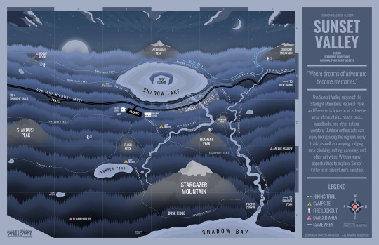
One of the key locations of my indie animated series Where's Willow? - A Firefly City Story is the Flashpoint Trail which leads through the Starlight Mountains.
The Flashpoint Trail is a 35-mile (56-km) long hiking trail that loops around the eastern half of the Sunset Valley. Starting and finishing at the visitor center parking lot, it passes by several landmarks including Flash Rock, Stargazer Mountain, Photon Canyon, and Filament Peak. Its easternmost stretch along Dusk Ridge offers great views of the ocean!
Behind the scenes fact: The concept for this trail was inspired by a combination of the Buckeye Trail and the Appalachian Trail! It's supposed to be in between them in terms of hiking difficulty (the AT is very difficult, and the Buckeye Trail is a lot easier by comparison).
You can find a full map of the show's setting here!
If you haven't checked out the animated series yet, find it here on the Firefly City Stories YouTube channel!
#firefly city stories#whereswillow#whereswillowseries#animated series#indie animation#indie animated series
3 notes
·
View notes
Text
Where's Willow is a part of this zine, as well as a lot of other awesome shows and projects! Check it out!
🎉PREORDERS OPEN🎉
Preorders for the Indie Animation Zine are now open! View our bundles below ⬇️
🛒 Shop: https://indieanimezine.bigcartel.com
🌐 International: https://forms.gle/2nCWGnAc28MLGQhQ8
🗓️ Open until March 31st


#indie animation#indie#animation#zine#cartoon#fanzine#fan zine#anime#independent animation#indie anime#indie cartoon#indie animated series#indie pilot#zine promo#zine preorders#preorders open#wwfcs#fireflycitystories#firefly city#wheres willow series#whereswillow#whereswillowseries
31 notes
·
View notes
Text
⭐ Episode one of my animated series Where's Willow? - A Firefly City Story releases THIS FRIDAY!!!
Check out the show and subscribe to the Firefly City Stories YouTube channel so you don't miss it!
If you want to get a look at the setting of the show, here's a map of the Sunset Valley region of the Starlight Mountains National Park!
"The Sunset Valley region of the Starlight Mountains National Park and Preserve is home to an extensive array of mountains, ponds, lakes, woodlands, and other natural wonders. Outdoor enthusiasts can enjoy hiking along the region's many trails, as well as camping, lodging, rock climbing, rafting, canoeing, and other activities. With so many opportunities to explore, Sunset Valley is an adventurer's paradise."
⭐ You can see a detailed writeup of the creation process (with a PDF download) for FREE over here on the Firefly City Stories Patreon!
Behind the scenes fact: The map was one of the first pieces of artwork I made for the show. A lot of it was done during leftover time in my audio engineering class where we had 3 hours to do a 20 minute project lol. While it took about a week's worth of days to make all on its own, it was worth it because it really helped guide the writing process. The hardest part was figuring out how to show dimension in the landscape (a lot of gradients). Throughout the years of the show's production, I would occasionally go back and tweak a few things here and there, but the original vision stayed about the same. My computer hates whenever I go in to edit it (it's a very intensive file).
- Mitch
#firefly city stories#whereswillowseries#whereswillow#wwfcs#maps#map art#imaginary maps#animated series#indie animation#indie animated series
1 note
·
View note