#wingtra
Text
youtube
Randall Warnas joins Chris Kenney, Wingtra US Channel Manager, to discuss the exciting capabilities of this unique VTOL aircraft. Watch the video, Dronefly webinar excerpt wingtra applications for use.
#drone dji mavic#cheap drones#drone video#drone photography#dronefly wingtra webinar#dronefly#audience questions#dji mavic mini 2#remote control drone with camera#free webinar#Youtube
1 note
·
View note
Text
WingtraCLOUD se actualiza para mejorar sus capacidades de procesamiento de mapas.
La empresa suiza de tecnología aérea Wingtra ha anunciado una importante actualización de su plataforma WingtraCLOUD, incorporando características avanzadas de procesamiento de mapas diseñadas para profesionales en sectores como la construcción, la minería y la planificación urbana. Esta nueva funcionalidad tiene como objetivo hacer que los datos aéreos sean más accesibles y procesables para los…
0 notes

Text
0 notes
Text
Fixed-wing VTOL UAV Market Size, Share & Revenue Analysis: 2028
Fixed-wing VTOL UAV Market by Vertical (Military, Government & Law Enforcement, Commercial), Propulsion (Electric, Hybrid, Gasoline), Mode of operation (VLOS, EVLOS, BVLOS), Endurance, Range, MTOW, and Region (North America, Europe, Asia-Pacific, Middle East and Africa and South America)
The Fixed-Wing VTOL UAV Market is projected to reach a CAGR of 18.4% from 2021 to 2028.
Fixed-wing VTOL UAV refers to the fixed-wing vertical take-off and landing (VTOL) unmanned air vehicle (UAV). They are commonly known as drone and are capable of being operated autonomously with any human pilot. A fixed-wing VTOL UAV can hover, take-off, and land vertically like a helicopter with help of rotors. The vehicle is primarily designed for high aerodynamic performance and low take-off weight. Aerodynamics design steps and sizing of both wing and static stability is fulfilled by evaluating the centre of gravity location with respect to the neutral point.

The increasing adoption of fixed-wing VTOL UAVs in various commercial applications, such as monitoring, surveying & mapping, agriculture, aerial remote sensing, product delivery and rise in the adoption of technologically advanced runway less unmanned aerial military platforms by defence forces are some of the factors that have supported long-term expansion for Fixed-wing VTOL UAV Market.
Request For Free Sample Report: https://www.delvens.com/get-free-sample/fixed-wing-VTOL-UAV-market-trends-forecast-till-2028
Regional Analysis
North America is estimated to be the largest market for fixed-wing VTOL UAVs in 2019, followed by Asia Pacific and Europe. This is attributed to the high demand for fixed-wing VTOL UAVs from the US, for applications such as firefighting & disaster management, maritime security, agriculture, product delivery, and inspection & monitoring, among others.
Key Players
Alti UAS
Arcturus UAV, Inc.
Bluebird Aero Systems LTD
Elroy Air Inc.
Lockheed Martin Corporation
Quantum-Systems GmbH
Textron Inc.
Ukrspecsystems
ULC Robotics Inc.
Vertical Technologies Ltd.
Make an Inquiry Before Buying: https://www.delvens.com/Inquire-before-buying/fixed-wing-VTOL-UAV-market-trends-forecast-till-2028
Recent Developments
In 2020, Wingtra announced the release of its new payload – MicaSense Altum, which is useful for agricultural and closely monitoring water stress areas. This payload provides a high-resolution thermal (down to 54 cm or 21 in/px) and multispectral (down to 3.4 cm or 1.3 in/px) imagery.
In 2020, Larsen & Toubro (L&T) signed a pact with ideaForge to offer allied systems and drones for defense use. Both companies integrated their strengths to provide Hi-tech drone solutions to improve surveillance and security.
Reasons to Acquire
Increase your understanding of the market for identifying the best and suitable strategies and decisions on the basis of sales or revenue fluctuations in terms of volume and value, distribution chain analysis, market trends and factors
Gain authentic and granular data access for Fixed-wing VTOL UAV Market so as to understand the trends and the factors involved behind changing market situations
Qualitative and quantitative data utilization to discover arrays of future growth from the market trends of leaders to market visionaries and then recognize the significant areas to compete in the future
In-depth analysis of the changing trends of the market by visualizing the historic and forecast year growth patterns
Get Direct Order of this Report: https://www.delvens.com/checkout/fixed-wing-VTOL-UAV-market-trends-forecast-till-2028
Report Scope
Fixed-wing VTOL UAV Market is segmented into vertical, application, mode of operation, range, MTOW, propulsion, endurance and region.
On the basis of Vertical
Military
Commercial
On the basis of Application
Border Management
Traffic Monitoring
Firefighting & Disaster Management
Search & Rescue
Police Operations & Investigations
Maritime Security
On the basis of Mode of Operation
Remotely Piloted
Optionally Piloted
Fully Autonomous
On the basis of Range
Visual Line of Sight (VLOS)
Extended Visual Line of Sight (EVLOS)
Beyond Line of Sight (BLOS)
On the basis of MTOW
<25 Kilograms
25-170 Kilograms
>170 Kilograms
On the basis of Propulsion
Electric
Hybrid
Gasoline
On the basis of Endurance
<5 hours
5 – 10 hours
10 hours
On the basis of Region
Asia Pacific
North America
Europe
South America
Middle East & Africa
About Us:
Delvens is a strategic advisory and consulting company headquartered in New Delhi, India. The company holds expertise in providing syndicated research reports, customized research reports and consulting services. Delvens qualitative and quantitative data is highly utilized by each level from niche to major markets, serving more than 1K prominent companies by assuring to provide the information on country, regional and global business environment. We have a database for more than 45 industries in more than 115+ major countries globally.
Delvens database assists the clients by providing in-depth information in crucial business decisions. Delvens offers significant facts and figures across various industries namely Healthcare, IT & Telecom, Chemicals & Materials, Semiconductor & Electronics, Energy, Pharmaceutical, Consumer Goods & Services, Food & Beverages. Our company provides an exhaustive and comprehensive understanding of the business environment.
Contact Us:
UNIT NO. 2126, TOWER B,
21ST FLOOR ALPHATHUM
SECTOR 90 NOIDA 201305, IN
+44-20-8638-5055
0 notes
Text
Wingtra Introduces RGB61 Payload: The Fastest Mapping Drone Just Got Faster
http://dlvr.it/SpkpFr
0 notes
Text
Wingtra Introduces RGB61 Payload: The Fastest Mapping Drone Just Got Faster
http://dlvr.it/Spk24J
0 notes
Text
Wingtra Introduces RGB61 Payload: The Fastest Mapping Drone Just Got Faster
http://dlvr.it/Spk1qT
0 notes
Link
0 notes
Text
Mapping drone startup Wingtra is charting a new future after landing $22M
http://dlvr.it/SlD9Wt t.ly/m_Jb
0 notes
Text
Aerial Imaging Market Share, Trends, Segmentation and Registering a Strong Growth by End of 2032
The aerial imaging market is expected to witness robust expansion by 2032 due to rapid advancements in aerial camera systems and drone technology across the globe.
Aerial imaging innovation and strong technological advancements will support industry growth. Aerial imaging companies are constantly working to create cutting-edge camera systems that will support a range of imaging applications. In addition to reducing emissions and documenting the effects of climate change, aerial photography is extremely important. Increased occurrences of natural disasters like floods, tropical cyclones, storm surges, and wildfires will increase the need for and significance of cutting-edge aerial imaging solutions to evaluate the harm brought on by such events.
Advancement in aerial photo analysis to improve system demand
The platform segment in aerial imaging market is expected to record over 20% CAGR from 2023 to 2032. Developments in artificial intelligence (AI) and machine learning have supported the improvement of highly sophisticated image analytics platforms that can analyze large numbers of aerial images.
Get sample copy of this research report @ https://www.gminsights.com/request-sample/detail/105
Growing crime rate to boost system application in surveillance monitoring
Aerial imaging industry from surveillance monitoring application accounted for over 21% in 2022. In both the commercial and residential sectors, surveillance monitoring using aerial imaging has become more common. Globally, the demand for surveillance systems has increased due to rising crime rates. In urban settings, the need for these systems is growing due to a number of threats, including robbery, kidnapping, etc. Because of the increase in international terrorist activities, UAVs are expected to play a bigger role in efforts to address complex military concerns.

High significance of aerial imaging for oil field monitoring
The aerial imaging market share from the oil & gas end-user segment is expected to observe 23% growth between 2023 and 2032. Expanding operations in the oil and gas sector has accelerated the application scope of UAVs for field inspection and overheating component detection. Component overheating can cause power interruptions and possible financial loss due to which it needs to be monitored continuously. Oil and gas companies are therefore making use of drone and UAV technologies to find gases and significant leaks.
Presence of key aerial imaging companies in North America
In 2022, the aerial imaging market in North America was expected to generate more than $1 billion in revenue. The presence of businesses in the area and the high system adoption in many industrial applications have aided industry development. The increased use of UAVs in the defence industry for security and surveillance is expected to increase demand for imaging solutions. The adoption of drones for safety reasons and advanced technological development in UAVs will have an impact on regional growth.
Request for customization @ https://www.gminsights.com/roc/105
New product launches to facilitate industry expansion
Key industry players in the competitive landscape include Cooper Aerial Survey, DroneDeploy, Eagle View Technologies, Fugro NV, Wingtra, Getmapping Plc, Kucera International, Airobotics, Landiscor, Hoverfly technologies, NearMap Ltd, Precision Hawk, DJI Technology Co., Ltd., and Sanborn Map Company, Inc. Companies are focusing on the development of new imaging systems and solutions that support enhance imaging capabilities.
In September 2022, Eagle View Technologies announced the debut of EagleView Cloud, a new aerial imagery and software service that aids customers in making quick and informed decisions and can be customized with different picture resolutions, more frequent image transmission, and more visualization capabilities.
Table of Contents (ToC) of the report:
Chapter 1 Methodology & Scope
1.1 Market definitions
1.2 Base estmates & calculations
1.3 Forecast calculation
1.4 COVID-19 impct
1.4.1 North America
1.4.2 Europe
1.4.3 Asia Pacific
1.4.4 Latin America
1.4.5 MEA
1.5 Data Sources
1.5.1 Primary
1.5.2 Secondary
1.5.2.1 Paid sources
1.5.2.2 Public sources
Chapter 2 Executive Summary
2.1 Aerial Imaging market 360º synopsis, 2018 – 2032
2.2 Business trends
2.2.1 Total Addressable Market (TAM)
2.3 Regional trends
2.4 Platform trends
2.5 Imaging type trends
2.6 Application trends
2.7 End-use trends
Browse complete Table of Contents (ToC) of this research report @ https://www.gminsights.com/toc/detail/aerial-imaging-market
Electronics and Semiconductors Research Reports
Time-Sensitive Networking Market
Streaming Devices Market
Data Center Services Market
About Global Market Insights:
Global Market Insights, Inc., headquartered in Delaware, U.S., is a global market research and consulting service provider; offering syndicated and custom research reports along with growth consulting services. Our business intelligence and industry research reports offer clients with penetrative insights and actionable market data specially designed and presented to aid strategic decision making. These exhaustive reports are designed via a proprietary research methodology and are available for key industries such as chemicals, advanced materials, technology, renewable energy and biotechnology.
Contact Us:
Aashit Tiwari
Corporate Sales, USA
Global Market Insights Inc.
Toll Free: 1-888-689-0688
USA: +1-302-846-7766
Europe: +44-742-759-8484
APAC: +65-3129-7718
Email: [email protected]
#Aerial Imaging Market Analysis#Aerial Imaging Market by Type#Aerial Imaging Market Share#Aerial Imaging Market Development#Aerial Imaging Market Growth
0 notes
Text
youtube
Randall Warnas joins Chris Kenney, Wingtra US Channel Manager, to discuss the exciting capabilities of this unique VTOL aircraft.
#the best drones#dji mavic 2 pro#remote control drone#best drone with camera#drone dji mavic#cheap drones#cheap drones with camera#small drones with cameras#drone video#Youtube
0 notes
Text
La fabricante suiza de drones Wingtra ha logrado asegurar 23 millones de euros en su ronda de financiación Serie B1.
La empresa suiza Wingtra, líder en tecnología de drones, ha logrado recaudar 25 millones de dólares (aproximadamente 23 millones de euros) en su ronda de financiación Series B1, atrayendo inversiones de diversos fondos destacados y oficinas familiares de Estados Unidos, Suiza y Austria. Entre los inversores clave se encuentran Brick & Mortar Ventures, DiamondStream Partners, Cadence Growth…
0 notes
Text
Which Drones Are Best For Mapping?

The answer depends on what you are trying to map (or model) and how large that area is. First, there is a distinction between mapping and modeling. A map is a top-down representation of features on the ground laid out spatially in a way that you could measure the distance between any two points on that map (e.g. Google Earth is a map of the earth). Maps can also have an elevation component to them as well either displayed via contouring or as a Z value embedded in each pixel of a raster DEM. A model is a 3D recreation of an object or structure (e.g. Google Earth, in some places, has 3D modeled cities that can be viewed as a layer over the map). While both are derived from imagery, different drones are more suited for each.
Airframes
Modeling requires the ability of the drone to hover around an object taking photos at extreme oblique angles, possibly even from below in the case of bridges. Multirotor drones excel here as they almost have gimbals to support and control their payloads.

DJI, Microdrones, and Skydio are probably the most well-known manufacturers in this space. However, of the three, DJI and Microdrones are also capable of acquiring imagery for mapping. Skydio’s focus is on autonomous modeling. With no aerodynamic properties, they rely on constant power to the rotors to stay aloft, much like a helicopter. Therefore the area that they can map per flight is relatively small.
There are now multirotor drones that operate for longer durations using fuel cell technology or as hybrids using a combination of gas and battery power. These drones were designed to carry heavier payloads such as LiDAR. Note that increased payload capacity results in larger drones and more power consumption. So the tradeoff is less portability and more stringent maintenance and storage requirements,

Fixed-wing drones have all the aerodynamic properties of conventional aircraft relying primarily on lift and power to keep them in the air. They are always in forward motion therefore not well suited for modeling. However, fixed-wing drones are very efficient and can typically operate for much longer durations per flight. This allows for the mapping of much larger areas. Systems such as Wingtra, Quantum Systems, and Sensefly can all fly 2 to 3 times longer than the majority of multirotor drones.
Of the three fixed wings listed, two, the Wingtra and Quantum Systems also have Vertical Takeoff and Landing (VTOL) Capabilities allowing them to launch and land without the need for a runway or open field.
Sensors
Multirotor drones currently carry a wider variety of sensors. This is due to their increased lift capabilities, ability to stop and hover during flight, and the incorporation of gimbals to control some sensors. RGB cameras (with zoom capabilities), Video, Thermal, Multi Spectral, and LiDAR sensors can all be found underneath multirotor drones.

Fixed wing drones carry fewer payloads primarily because of their constant forward flight characteristics and weight limits. RGB, Thermal and Multi Spectral sensors with fixed focal length lenses (better suited for mapping) can typically be found underneath fixed wing drones. LiDAR systems are still a bit too heavy for fixed wing currently. That and the speed at which they fly in proximity to the ground is a limiting factor in the point densities attainable with current LiDAR technology.

Metric Cameras vs COTS sensors. Metric Cameras are cameras that have precise known measurements and are not susceptible to deviations due to environmental conditions. They typically have the highest quality fixed focal length lenses and are professionally calibrated by the manufacturer to ensure all parameters are known. These are found more often in mid-size or large format cameras. The majority of sensors supplied on drones are COTS sensors and do not have a fixed focal length. This can result in less than optimal mapping results. This is why Correlator3D minimizes this by performing a boresight calibration during the AT process to calculate the camera's true parameters.
Positioning systems.
Both Multirotor and Fixed-wing drones carry onboard GPS to determine and report their location at any given moment. When using a drone for modeling or mapping each image captured gets tagged (Geotagged) with location and altitude at the time of capture. This allows mapping software such as SimActive’s Correlator3D to import and assemble a series of images for aerotriangulation and bundle adjustment.
Basic GPS information is accurate to approximately 3 meters. Correlator3D in the AT and bundle adjustment process will refine this error and eliminate it relative to the scene being mapped. With ground control, the resulting DEM and Orthomosaic can be extremely accurate. Other GPS solutions used onboard drones are Real-Time Kinematic (RTK) and Post Processed Kinematic (PPK) GPS. RTK requires a base station on-site collecting GPS information in tandem with the drone correcting the position in real-time. This can bring the drones' reported position from meters into centimeters.
RTK requires the additional expense of a base station. The potential drawback is that if the base and the drone lose their connection, there is no recovery in reporting quality positions. Therefore it is recommended that the drone GPS be capable of acquiring both the L1 and L2 GPS signals for redundancy.
PPK does the same without an onsite base station. Instead, it relies on a network of established stations selecting the nearest operating one and a correction is applied to the drone's reported position through post-processing.
The drawback can be the delay in receiving a post-processed solution. This can take as little as an hour for initial results to days if the most accurate results from the ephemeris solution are desired. Proximity to the nearest operating station can affect results, and in some areas, there may not be an operating station eliminating your ability to use PPK.
PPK was originally designed to be used in mapping projects where the placement of ground control would be extremely difficult. However, in both cases, control is still required to generate the most accurate mapping results.
The final positioning component is the Inertial Measurement Unit (IMU). Where GPS provides the Z, Y, and Z location of the drone, and IMU provides the exact orientation roll, pitch, and yaw aka omega, phi, and kappa. These are necessary when using a Fully constrained AT or Direct georeferencing solution for your bundle adjustment in Correlator3D. Like onboard GPS equipment, the quality of the IMU can greatly affect the results of processing. In fact, the typical IMU that comes installed on COTS drones, should not be used in constrained AT or Direct georeferencing bundle adjustments. These are for extremely precise IMU such as Applaniz and Novatel systems.
Summary
Each type of drone has its own benefits and excels for specific uses. The following is a quick table breaking them down.
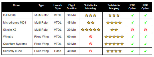
Note there are base models and upgraded models represented here. Costs can vary widely given the options chosen. Also, this is a list of the more popular drones on the market today. There are many others available that may suit a specific need better than these.
When choosing a drone or drones for your program, consider the type of work you will most likely be doing. Consider your accuracy requirements and the additional expense of survey equipment necessary for RTK solutions. Or conversely, possible cost savings over time with a PPK solution. Lastly typical project size: will hot-swapping batteries with multirotors suffice or should you go for a fixed-wing with longer flight durations?
0 notes
Photo

#Wingtra Ventas www.hobbytuxtla.com https://www.instagram.com/p/CDe63g7nqTM/?igshid=1uvtv7u37n6oy
0 notes
Photo

Wingtra and Esri collaborate for easy construction and planning of a quarry ESRI, famous for its ArcGis platform and other geographical data software, used the high quality images from the VTOL WingtraOne to gain critical data for construction and planning of a quarry in Switzerland.
0 notes
Last Seen Blogs

hyorin
ya

you-can-quote-me-on-that
Wanderlust_21

nurselensen-blog
burası beni çöplüğüm

rustys-cc
Rusty's

ntnsdesigns
NTNS Designs