#dji mavic 2 pro
Text
Gundog Training - Wirral Gundogs Training Ground
This film shows the training of two labrador retrievers being sent over a lake to hunt for a retrieve on the far bank. It demonstrates …
source
#Cocker spaniel#DJI Mavic 2 Pro#Drone film#Gundog#gundog training#gundog working test#hunting#LABRADOR#Nick Ridley#nickridleyphotography#Retriving#shooting#Spaniel#stud dog#Wirral Gundogs#working test
0 notes
Text
Choisissez le bon drone pour vos besoins de cartographie aérienne : 5 propositions
Les drones révolutionnent la cartographie aérienne. Ces nouveaux outils polyvalents pour des résultats de haute précision
La cartographie aérienne a connu une véritable révolution grâce à l’introduction des drones. Ces appareils volants équipés de caméras de haute résolution et de capteurs spécifiques offrent une solution efficace et économique pour la collecte de données géospatiales. Que ce…
View On WordPress
0 notes
Text
youtube
Randall Warnas joins Chris Kenney, Wingtra US Channel Manager, to discuss the exciting capabilities of this unique VTOL aircraft.
#the best drones#dji mavic 2 pro#remote control drone#best drone with camera#drone dji mavic#cheap drones#cheap drones with camera#small drones with cameras#drone video#Youtube
0 notes
Text
Venlo | Stadshaven en nieuwe Lage Loswal in aanbouw
Woensdag, 16 december 2020 | De werkzaamheden aan de Lage Loswal in Venlo vorderen gestaag. De beste manier om een overzicht te krijgen van de de vorderingen kun je vanuit de lucht zien. Daarom heb ik vandaag een bezoek gebracht aan deze nieuwe parel aan de kroon van Venlo.
De vlucht van mijn drone gaat zoals de titel van deze publicatie aangeeft over zowel de Lage Loswal alsook over de…

View On WordPress
0 notes
Photo
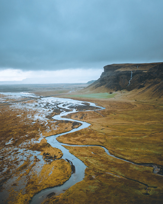
64°50'34.2"N 14°40'13.9"W
instagram/oftwolands
www.oftwolands.com
#iceland#river#landscape#aerial#drone#mavic 2 pro#dji#travel#explore#Adventure#moody#dark#nature#of two lands
1K notes
·
View notes
Video
Red tulips queueing for the sunset. Ruigeweg, Burgerbrug, Holland. by Alex de Haas
#DJI#Dutch#Europa#Europe#HDR#Holland#M2P#Mavic#Mavic 2 Pro#Nederland#Nederlands#Netherlands#Noord-Holland#The Netherlands#Tour des Fleurs#aerial photography#agriculture#agricultuur#bloemen#bloemenvelden#bollenvelden#bulbfields#drone#farmland#flower fields#flowers#landbouw#landscape#landschaft#landschap
7 notes
·
View notes
Text

Frosted tips 🏔
📷: @franconic89 📍: Italian Alps 🚁: DJI Mavic 2 Pro
#dronephotography#aerial photography#mountains#droneoftheday#aerial view#dronepilot#dji#mavic 2 pro#italy#earth#drone#planet#amazing places
19 notes
·
View notes
Text
Fehmarn
2 notes
·
View notes
Text
A 4 shot stitched panoramic view from my drone earlier this week.
#northcarolina#ncphotography#photographer#blue ridge mountains#blue ridge parkway#drone photography#dronelife#dji mavic pro 2#dji#djiglobal#panoramic#panorama
0 notes
Text
#air drone#best dji drone#buy dji#buy dji drone#buy dji mavic 3#buy drone#buy mavic 3#dj1 store#dji 2#dji 2s#dji 3#dji 3 pro#dji accessories#dji agriculture#dji agriculture drone#dji air#dji air 3#dji air 3 release date#dji air unit#dji app#dji battery#dji battery charger#dji camera#dji canada store#dji charger#dji classic 3#dji contact#dji customer service#dji drone accessories#dji drone app
0 notes
Text
Gundog Training - "Ted" in the rabbit pen.
I had the opportunity to put Ted my cocker spaniel in the rabbit pen for the very first time. Although he is an experienced gundog it …
source
View On WordPress
#Cocker spaniel#DJI Mavic 2 Pro#Drone film#Gundog#gundog training#gundog working test#hunting#Nick Ridley#nickridleyphotography#Rabbit Pen#Rabbit Shooting#shooting#Spaniel#stud dog#working test
0 notes
Text
DJI Air 2S Specifications
Overview
The DJI Mavic Air 2S is a powerful drone that combines portability and functionality in one package. The drone features a 1-inch CMOS sensor that captures high-quality images and videos, along with a range of intelligent flight modes that make capturing stunning footage easier. The drone’s design is sleek and compact, with foldable arms that make it easy to store and transport.
One of…

View On WordPress
#4k drone#Air 2S Specs#camera drones#commercial drones#dji#dji drones#dji mavic air#dji mavic air 2#dji mavic air 2s#dji mavic pro#drones
0 notes
Text
youtube
In this webinar excerpt, join Enterprise UAS EVP Randall Warnas and Parrot Drones Sales Manager François-Xavier Charbonnel as they discuss the mapping and surveying with the Parrot ANAFI Ai.
#drone camera price#dji mavic 2 pro#dji phantom 4#dji phantom 4 pro#dji phantom#phantom 4 pro#flying drones#drone photography#best drone with camera#remote control drone#Youtube
0 notes
Text
Venlo | Dronevlucht over het hoogwater
Woensdag, 5 februari 2020 | Venlo wordt bij tijd en wijle getroffen door Hoogwater. De afgelopen jaren heb ik al een aantal publicaties aan het Hoogwater in Venlo gewijd. Waren het vooral foto’s die gemaakt zijn op de hoogte van het maaiveld, in de toekomst zal dit anders zijn omdat ik inmiddels over meerdere drones beschik.
Venlo | Hoogwater, februari 2020
Klik hier voor de film en hier voor de…

View On WordPress
0 notes
Photo
44°58'23.5"N 6°03'54.8"E
youtube/oftwolands
www.oftwolands.com
#france#autumn#outdoor#lifestyle#French alps#alps#tree#colors#woods#alone#tranquilness#peaceful#photography#aerial#drone#dji#mavic 2 pro#landscape#of two lands
308 notes
·
View notes
Video

flickr
Ruigeweg, village of Burgerbrug, The Netherlands. by Alex de Haas
#DJI#Dutch#Europa#Europe#HDR#Holland#M2P#Mavic#Mavic 2 Pro#Nederland#Nederlands#Netherlands#Noord-Holland#The Netherlands#Tour des Fleurs#aerial photography#agriculture#agricultuur#bloemen#bloemenvelden#bollenvelden#bulbfields#drone#farmland#flower fields#flowers#landbouw#landscape#landschaft#landschap
3 notes
·
View notes
Last Seen Blogs

juliadreamart-old
~*julia's art blog~*

onlinegymclothing-blog
Online Gym Clothing

noonewhocomesherelives
I have a will for survival

ivettetlc
Conoce Cómo lograr Perder Peso sin Rebote ni Efectos secundario

jule-d
Jwù-To