
Don't wanna be here? Send us removal request.
Statistics
We looked inside some of the posts by y3s2-20192020 and here's what we found interesting.
Average Info
Notes Per Post
1
Likes Per Post
0
Reblog Per Post
1
Reply Per Post
0
Time Between Posts
9 hours
Number of Posts By Type
Text
14
Photo
3
Last Seen Tumblr Blogs


Fun Fact
Tumblr was named as a finalist in Lead411’s New York City Hot 125 in Aug 2010.
Text
Renaturalization of the machines
youtube
As machines and machine intelligences replace the role of humans in the rural landscape, over time, the rural world as we know it will be reshaped in the image of the machine and natural forces. A different type of rural augmentation emerges, one made not by humans but by machines. Intelligences shift between mechanical and biological bodies, morphing what was once a rural landscape into a meta natural wilderness. It is a wilderness inhabited by mysterious entities. Part machine, part nature, these entities are alien yet familiar, estranged yet uncanny. This machine wilderness no longer welcomes our presence as it carries out the tasks that humanity has forsaken. The city centralizes its being, while nature decentralizes along with the machines across the landscape.

My project explored Korat’s rural landscape through the lens of monoculture silk farming. Understanding how it impacts and is impacted by environmental ecologies and economics on the larger scale

and throughout the smaller scales of biology and societal lives of the people in the area.

Through this research i found out that this industry was on a decline due to how environments and the atmosphere in the landscape has shifted due to changing methods of agriculture and industrialization by society, noise, soil quality, and ambient temp/humidity.
Which the obvious proposal would be to revive this industry through advanced Iot and AI technology.

However, for me i actually wanted to explore this project through a different perspective, and instead of focusing on creating that type of proposal, i want to actually question why is it that AI and machines are the first thing we look to when faced with these ecological and societal obstacles within the rural landscape; and to critique the obsession and fears we as have as designer to force technological automation as the cure all be all, the solution to unsolvable problems, the deus ex machina - trying to find god in the machine
youtube
And thus this is the new world constructed through those values
youtube
And created via a process involving mutliple stakeholders over a long period of time and restructuring existing infrastructures in present day korat to allow for this new world that centralizes humanity while decentralizing nature.
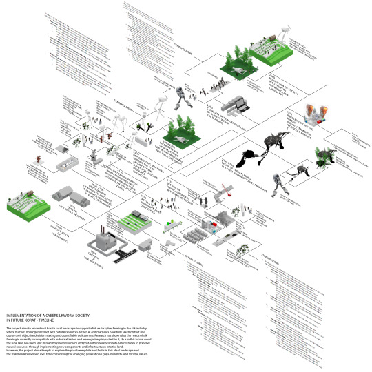

We have come to a new way of living for society where machines and machine intelligences replace the role of humans eventually augmenting the rural nature to their image

A meta natural wilderness of machine and biological bodies, that initially supported the existance of humanity. Yet at the same time it became a landscape that is familiar yet alien. estranged yet uncanny.
youtube
It becomes a place that no longer welcomes the image and scale of humanity even though we are the children of nature and also the ones who made the machines existing there
youtube
And this new relationship between the machines and nature that create a landscape of ever changing scales is a concept incomprehensible by humans, because
As designers and as humans for centuries we’ve always been constructing the world based around us as the center and the image of the universe, everything to relate to the scale of our body, however it is naive to believe that that will continue like that forever. To see that change around us, to see it become a scale so unknown so foreign, unable to get an accurate image of it

0 notes
Text
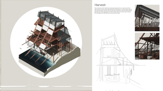
Catching the Clouds:Neo-Infrastructures of Post-Climate Change

The United Nations Environment Programme predicts that if emissions continue to increase at the same rate as they have in 2010–2020, global temperatures will rise by as much as 4°C by 2100. Since the 1950s, droughts, heat waves and erratic wind patterns have appeared simultaneously with increasing frequency, with agricultural production projected to be among the hardest hit industries in the future. Located in Korat, Khonburi, the project proposes a speculative infrastructure that mitigates the effects of drought on agriculture through the exploitation of the regional topography, altitude and proximity to the Ta-phraya Rainforest.

Located 650-770 meters above sea level where cumulus clouds form, the infrastructure comprises a series of winged towers that collect and store water vapour from the atmosphere. The microscopic surface properties of the tower’s wings cause the moisture in the air to condense into larger droplets that can be directed to the tower’s large central tank. The structure responds to weather data and climate forecast models to rotate according to prevailing wind and weather conditions to harvest resources and determine the controlled release of water into local streams that feed the region’s reservoirs.
The project is an exploration of new infrastructural systems that may emerge from projected climate conditions.


0 notes
Photo


Chonburi Coastal
I am categorized it by the province in chonburi that has the depth of coastal differently
First province is bangsaen that has deep sand topography and alot of port and very have only one beach
Next is Pattaya City this province is the most popular area in chonburi and has a middle depth of sand topography because . this area also have alot of tourist and recreation activity in this area
Last one is Sattahip province that has the most steep topography and has a preservation center in this area.
What the problems of Coastal in Chonburi is the coastal erosion that is very intense.
This is showing the timeline of the beach reclamation that government trying to fight back to attractive tourist and increase economy in this area
This showing big sand reclamation that happens in 2018 and 2019
And another way that we can slowdown the coastal erosion is coastal protection that using the break water or jetty to slow down the waves before hitting the coastal
Then I using the scientific data that have the prediction of the situation that will happens in the future just like sea level rise the caused by global warming and make the waves more bigger.]’
This diagram is showing the cause and effect of climate change how it effect to coastal
Then i categorized 3 aspect that have in chonburi coastal which are biodiversity tourist land and coastal
Now these 3 aspects are having conflict. Just like if we are doing beach reclamation it is increasing the land and area for tourist but the biodiversity will got disturb
Then i using the old data and the scientific prediction to generate the situation that can be happen in future
Like this one that in between 2040-2060 the sea level will rise 1 to 1.5 meter and the sand reclamation that done in 2019 will eroded
First i trying to increasing the height of the original beach to prevent the coastal flooding in future but then i trying to combine 3 aspect together and use it the most efficiency
Then i look into the problem of beach nourishment that where the sand come from
Rangkwean island that they use this island to sucking the sand and do the beach nourishment in pattaya beach
And I found that there are 2 types of coastal protection that they use: hard solution and soft solution. Then i research the effect of hard solution the the break water cause the damage to the coastal more than not having it
Like this one หาดแสงจัน and other place in thailand that have this problem
Then I am trying to solve the problem of sucking sand from another island by finding the process of how we can produce sand by yourself . we can this crushing machine to crush rock or gravel into sand but it mean we have to get rock and gravel from somewhere again
Then i trying to use the recycling process of glass bottle that can crushing into sand and use for beach nourishment
1 bottle can crush into 200 gram of sand then i do the quick math of beer consumption in thailand that how many bottle we have in each year
We can get 48,380 tonnes of sand per years this number is more than the big reclamation in pattaya for around 23 times
If you don't know how much it is, you can see in sansar that the small one is pattaya beach and the bigger one that we can produce every year.
But in reality we can not gather all of the bottles in thailand but we can use the benefit of tourists in pattaya city that have alot of tourists that drink beer to become part of it.
The process if crushing the bottle and then gathering the sand for the geobag or beach nourishment and if it have leftover this sand can be used for construction material
What is geobag used for in the past in pattaya that use geobag to be the coastal protection but they put it on the beach and the wave also hit and eroded the sand inside and left over the garbage on the beach. I will using geobag as a base for the island the newly construct
This is my design intervention that uses a soft solution to prevent the problem in the future and can be a long term solution. This is part of Pattaya beach that i chose.
Duration to construct
I compare to the palm island in dubai that is more bigger than pattaya that use 6 year to finished but they are using the boat to do the reclamation if we are using the boat the duration will take 1years or faster
This is the depth and where the island is located
From first that is the original beach that will move all the activity to the center area of the island and to go island by island people can walk through island by island because there are the path of sand that steep enough to walk
This is how the activity moves from the original beach to the center area.
And also the bottle crushing machine that will be place in center zone for drinker to use the machine and the island can be use for function by function like this that we can have a bar at the center
The outer part island that will become an ecology island that will bring back the ecology that got disturb and lost from the past and also become the second barrier to protect the original beach from eroded and become the maintenance area that we can maintain or do the beach nourish every time.
0 notes
Text
Baan NukulKiri
What if large urban communities and industries were decentralised? What if emerging technologies, automation and IoT could not only co-exist with but actually enhance tradition, heritage and local backyard production in the countryside?
youtube
Baan NukulKiri is a community infrastructure that was informally constructed by small community groups,it resembles a small scale high tech local production process which is the re-enlightenment of today's countryside.


The project explores the potential of new technologies and digital infrastructure (such as the internet) to revitalise and repopulate the countryside. The structure explores the potential of unplanned informal growth coupled with a balance between high tech and low tech.These people act as a role of third hand experiencers where they use technology as just a platform of knowledge and adapted to their own understanding of how technology could function in their own way.

My aim is to explore the tension and relationships between community, identity and technology where the relationship between the context or the culture is connected through their nostalgic subconsciousness through technological apparatuses.


The project is separated into two parts; On ground and underground. With the onground, it consists of ground-level production such as livestock, agricultural land, or community zones.

While the underground would house more systemic infrastructures of the hidden systems that would potentially connect to the larger urban system like water systems or electronic systems.


Baan NukulKiri could be an influencer that raises new trends, styles and languages and also to raise a question of what the future might become. It could be weaved into our daily lives, cultural aspect or even influences from the surrounding landscape.


The infrastructure itself romanticizes the high tech and mooban aesthetic, in a small scale sublime way where there is a collision between cultural heritage, mysticism and technological advance. Where the structure itself choreographs a spatial relationship between these notions.
0 notes
Text
Self-Regulated Sea Border
Self regulated sea borders, explores strategies of informal monitoring, collective intelligence and DIY procedures, to speculate on possible attempts to provide a bottom up coastal control, questioning the role of architectural devices in this particular form of reclamation.
Rayong cost and maritime zone is a very conflicted territory, where the tensions between stakeholders with similar interests, like different communities of fishermen, from the province or from elsewhere, have been exacerbated by an increasing corruption and the inevitable decreasing of fish population.

There are two categories of Fisheries in the GOT, domestic fisheries and commercial fisheries. The project focuses on the second ones that, despite the appearances, are living in much more troubled times

To protect from indiscriminate fishing, Thai government officially banned “otter trawls”, the very deep fishing net that heavily affects the seabed, leaving an unnamed group of fishermen, according to my interviews, with strong ties with the province government, the possibility of using them, covering up their illegal actions.

How could these fishermen operate in legality, and at the same time take care of their portion of sea, without any real support from their government?
to find fishes in a silently over consumed territory, some of Rayong commercial fisheries ventured illegally outside the gulf of Thailand and this fact, combined to other aspects related to illegal workers, caused EU to suspect Thailand for trafficking.

A strategy of self monitoring is deployed making use of fisherman vernacular constructions and very normal fishing devices, called FAD - Fish Aggregation Devices, that can normally be deployed to attract and check the fishing population

The FADs are empowered with hidden simple cameras to monitor the activities of the illegal fishermen, and the evidence published on social media, creating a much more cohesive community of commercial fisheries, that opened and growth with the collaborations of makers and engineers attracted by the development of the EEC

The Self Monitoring FADs developed in Monitoring Platforms, hybrid platforms, half boat, half FAD, half floating platforms, able to provide a much more precise ability to monitor a larger level of parameters, from overfishing, to water acidification, to plastic pollution, to chemical runoffs, being also quite independent in harvesting energy.

The method of a successful DIY Marine Bots was adopted to create the “head” of the floating platform.
As mentioned, the platforms are the result of a positive collaborations between different actors, aimed to enhance more extensive monitoring methods through different open source sensors
This Floating Platform emerged from marine bots and FADs, which are used for monitoring under the surface of the ocean while being able to move around to certain places.
Generally the platform was designed to bend and articulate, which allows it to move through the wave, while dragging along certain structures.

However, the platform could reconfigure itself for higher precision, allowing it to precisely move to certain spots without wasting time.

In some occasions, the platform can be gathered and form up a larger space, which does not only expand the territory, but also provide more stability through the connections of multiple platforms, which is quite crucial sometimes especially during Monsoon, where the storm could occur at any time.

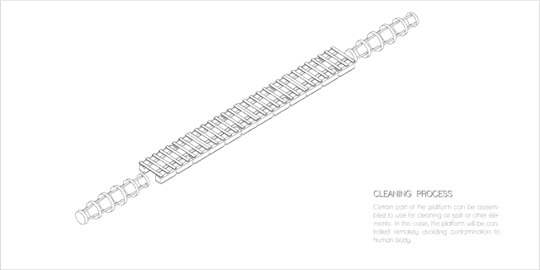
And lastly, taking various parameters into consideration such as water acidification or oil spilling, the platform can be used to clean a certain area of the ocean by re configuring itself into a cleaning tool.
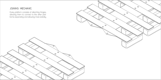
The articulation of the platform is enabled by the bending system with the metal plates that join each part together allowing flexibility for various configurations.

Also at the end of each platform, the interlocking plates are being attached, in order to connect multiple platforms allowing further expansion.
The rudders underneath of the platform are capable of bending according to the wind force. Therefore the momentum that was generated by the wind allows the platform to harvest energy from the movement of its own through the generator that connects to the rudder.

As an integration between FADs and Marine drone, the monitoring system was installed underneath of the platform, attaching to each rudder individually, allowing the under the ocean surface to be monitored before being stored in the data storage.


Their particular nature, mobile, their possibility to connect, detach, working in tandem or more individually seem to suggest different forms of cooperation, more dynamic, embracing the individual nature of existing commercial fisheries but at the same time requiring collaborational practices.
The monitoring platforms, natural development of FADS, are deployed along Rayong coast, moving according to monitoring needs. Eventually their use will expand, integrating more natural form of aquacultures and congregating in slower but steadier floating devices.

0 notes
Text
BURMA-THAI TRAIN LINE
For this project around the Kanchanaburi countryside I decided to focus it around the mythical railway line ordered by the Japanese during the Second World War and built by prisoners of mainly European nationality and which linked Burma to Thailand.The starting point is in Kanchanaburi, west of Bangkok, and it also indicates the beginning of my research. During my visit, I went to museums retracing the history of this famous line which connected the already existing train lines of the two countries between Bangkok and Burma.
After the Second World War, the more than 400 km long railway line connecting Burma and Thai- land was dismantled. Indeed, designed and built in haste, the infrastructure was not of good quality and had to be renovated every 3/4 months.
However, the Thai government bought the Nam Tok-Thonburi section from the allies and it is still in daily use.
The Nam Tok Thonburi section is therefore the only remaining usable legacy from this period. The variety of landscapes is remarkable as you can see at its different stations.
From my research, my film references and my pictures, we can therefore consider kanchanaburi as a real palimpsest and take the end of the railway line as the origin of a new project.
The still existing part will be considered as the historical heart with its 3 recognizable infrastuctures: Bridge over the kwai river, Wang Pho viaduct and Hellfire Pass.


Indeed, since 2012, Burma wishes to restore a line in order to be in direct relation with Thailand and to allow its very poor region to develop and offer an economic development and stronger links at the educational, social and tourist level with its neighbouring country.
This is why, in order to respect all its requests, we decided to offer an alternative to this old iron line which will continue the wooden iron line.
In order to preserve the historical route while respecting the landscape and the context already built along this route, traffic is envisaged in an aerial way. This installation on a territorial scale thus makes it possible to connect the two coun- tries and thus supports a new generation train allowing the transport of materials, data and people in a very fast way. It thus promotes commercial, economic and social exchanges. The infrastructure then offers on its roof, a pedestrian space, which is intended to be a place of pilgrim- age, in order to visit all the places and vestiges of the Second World War.


I decided to work on the site of the khao lem park, a place judiciously close to the Burmese border, having a fairly large topography and allowing us to envisage the integration of the overhead train line on the slope and a direct relationship with a body of water. Thus, the installation of a station here seemed obvious and was thought of not just as a stopping place but as a building designed as a continuity in the pedestrian pilgrimage and as a real promising space, a source of activities, a gathering place and one that would encourage exchanges between the two countries.


The architectural work was focused on the integration of the building, as it had to be designed as a response to the site and topography. So a real work on the integration into the slope in order to follow this shape was imagined in elevation in order to work in length and in section. One can thus notice the levels in anyone revealing three outdoor terraced spaces associated with the different levels but also, a double-level garden, bringing a strong identity to the project in relation to the train and its stop.
The interior spaces, punctuated by a bamboo forest, tend to offer more intimate and more closed spaces towards the outside with a visual relationship towards the sea but with a certain modesty towards the park.
Finally, vertical circulation is ensured by glazed lifts so as not to obstruct the view on the different floors but also to provide natural light to the whole building.

in order to understand in more detail the different levels that make up the building, referring us to this axonometry that reveals the upper floor and whose function is to welcome thesis students from both countries and to offer them temporary residence in order to foster a framework of excellence during their study. The structure made of posts/bamboos makes the interior space flexible and allows for the reception of numerous work spaces, but above all, offers students the possibility of arranging this space as they wish according to their respective projects. A terrace is assigned to them and offers a breathtaking view of the landscape. The fact that this space is located on the top floor guarantees students a great deal of peace and quiet.

Next, we find ourselves in the library which is open to the public in order to guarantee access to culture for all and therefore equally to the Burmese and Thai population while promoting cultural exchanges, but also to students who have privileged access due to their promiscuity. The bamboo structure can accommodate a significant number of shelves and the space is open to the outside with a terrace allowing for collective leisure activities such as ping pong or enjoying the sun and the view.

Then we find the level corresponding to the pilgrimage space: when we decide to take this new "green way" we find ourselves visiting a covered space, this space is meant to be a space to demonstrate the richness of the partnership between Burma and Thailand and therefore tends to be a space for temporary exhibitions and meetings.

Finally, the lower floor reveals the level of the train and the space that the train users reach. So we can see the half level of the train, which offers direct access to the garden at double height.

Thus the different interior spaces, although similar in their composition, offer different uses. Their similarity is however found in the search for intimacy, the distance from the outside spaces makes the spaces sequenced and closed in on themselves.
When we enter the building by foot, we discover the outside landscape only in segments, like a work of art hanging on the wall. The post structure then responds to the sculptures and provides sub-sites for the exhibition.

In the library, the external context is put at a distance thanks to the terrace but is still present in order to offer a spatial quality but also luminosity.

The view from the train is a strong image of this project because when we cross the building by train, we certainly take the garden and enjoy a view of the landscape punctuated by the vegetation of the garden and the users who take the stairs or the glass lifts.

Finally, the view of the garden reveals the immensity of the context and the park in relation to the terrace below, offering a real belvedere on the site.

0 notes
Text
Chapter 5 : Trekking through the traces of Nepalese community once in Pilok
The traces path become a trekking route to step on the history and experiencing the landscape that once Nepalese had enthonscape.

Divided into three trace of A B C. Section how the landscape look like in today

In conclusion, In the end of the episode of Nepalese enthnoscape in pilok. Where I took you through the traces of Nepalese community that are shaped by the world history event in past century. These people are a group of Nepalese cannot fully adapted with the new culture where they migrated to. And they Maintain cultural identity for the longest period. Which having these trekking to revival the history and giving awareness of people that once these Nepalese community was alive in Pilok.
#Pilok#chapter5#Trekking through the traces of Nepalese community once in Pilok#Marielouise Raue#6 Tida Tida Rama#Kanchanaburi#Phase 4
0 notes
Text
Chapter 4
6 tidaMine industry gradually shut down and disappearing of villages

Flow chart of Nepalese diaspora in Pilok through 4 generation.

Nepalese miner in Pilok had gain reputation as skilled miner. And Before the crisis Thai Government send a group of miners moved to work in other province to expand the mining industy

Satellite map of disappearing of Village from 1984 to 2018

The Present Nepalese in Pilok
#pilok#chapter3#disappearofcommunity#ThepresentNepaleseinPilok#Marielouise Raue#6 Tida Tida Rama#Kanchanaburi#Phase4
0 notes
Text
Chapter 3 : The end of mines in Pilok
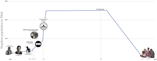
Come to the end of the mining in Pilok. So in 1985. The crisis of the world tin market crash of decreasing demand of tin since China had cost the tin mine in lower prices and Mine industry in Pilok and others are no longer maintain the price


Here is news paper talk about the crisis of tin market crash

the second reason is Water pollution that are consequces of mining extraction

0 notes
Text
Chapter 2.3 : Nepalese diaspora in Pilok after the World War II
In 1948 onwards caused booming of Mine industry and villages.

Later in the 1945 , When the world war II ended which was followed by Burmese Independence in the 1948, Most of Nepalese in Burma got expelled and unemployment. In directly mining industry in Pilok got economically growth, Nepalese people and mercenaries were employed to be mine worker in Pilok in huge no.

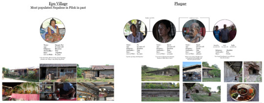
Phapae village consist of Nepalese people and later the village had transition to Mining area.


Here is an current house of Nepalese miners since the mine was active.

I used forensic architecture to invistigate the village in 1950 by constructing the houses position from the picture to 3 D model to understand what the village look like in 1950 and then I transform the model in to plan to see the position of the house in 1950.
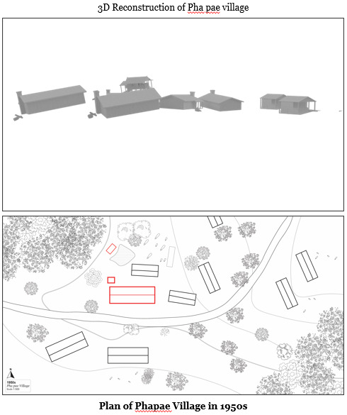
There is a plan of village in 1950 and in 2020 which the red line is the current house that still exit in today.

I also used the technique of forensic architecture into how does an old house in 1950 photograph look like in the 2020 picture. Through this technique I understand more how the house was used to be and how the new house is overlay with the old house.

The current house of Nepalese house since the mine was active. Here is the site plan.

Since their Lifestyle is based on mining and the working hours of miner are from morning till evening and OT till night so the house is where sleep and Keep mines and mining equipment.
The plan, front, Elevation and Back of the house.


Since these Nepalese people are diaspora from Nepal to Burma and to Pilok. But there was very few houses of Thai people in Pilok. These people still keep their lifestyle and environment based on Nepalese in Burma. Here is a difference colors that show the influences of the architecture of house arrangement from Burmese and Nepalese house.
Most of Burmese house are wooden rectangular form and Keep their Kitchen and bath separated from their living room. Mostly these Nepalese people still keep their tradition culture from Nepal .
The yellow part are element that define by being Nepalis. Firstly Which is cooking area that are unique kitchen of Nepalese house, Secondly Chair in front of their house and Lastly, having a wordship area with Buddha and Hindus

A route of Phapae people to market in Ethong for selling mines and To Burma sides to Fresh Market.

These community and mining industry in Pilok lifestyle extended for 40 years
0 notes
Text
Chapter 2.2 : Nepalese in Pilok recognized by Thai government
the mining industry start to start up in Pilok and Pilok became first Tin mining in Thailand with these Nepalese diaspora in Pilok as a skilled miner.

In 1939 The first flow were recognized by Karen hunter(Phapae and Pai) who live in the boarder and found that these foreigner are steeling mines from Thai area and selling to British so they both complain to the Headman of Pilok.

After these Nepalese miner in Pilok organised by Thai government. They enforced to stop all the mine work in Ethong. While the Thai government were trying to examine the mines. Later on in 1941, Government allow the first flow of Gurkha Army from Burma in Pilok as secure the village before the war in Burma.

After Thai government examine the mine they offered these Nepalese miners to work for them and in 1942 Official tin mining is approve and Nepalese miners continued the work for Thai company.

Somsak mining - one of biggest tin mining companies in who employed majority of Nepalese miners


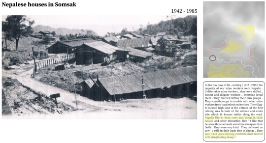
Nepalese houses in Somsak mining plan from the photograph above

0 notes
Text
Chapter 2.1 : Nepalese people enthnoscaping in Ethong
Ethong was the first mine and village for Nepalese diaspora in Pilok.

Plan of Ethong when the community start to settle and mining for their living without recognizing that they had crossed the British India side in 1926 till 1938

The first flow of Nepalese diaspora in Pilok are miners who work under the British industry in British India 1926 onward

The first group
Miner from Darjeeling and he was on the way to find the mine and mineral. He found the resources in Pilok without recognizing that it’s Thai land area so they start to settle and bring more people to Start mine in Pilok.
The second group
Miner working in The Heinda Tin mine, With recognizing that there is tin mine in Pilok from the first group Nepalese miner are order to move and settle in Pilok.
Mines type in Pilok are Tins and wolfram

Mining process in Pilok is similar to the heinda tin mining in Dawei which is Hydraulic process on open pit mining. Using bomb and water pressure to extract the mine from hard rock.

Mine scar in 2020 At Ethong mine


By comparing these two different period photograph of Ethong village. I’m trying to investigate the different in olden day look like in today.

Ethong Village plan in the olden day over lap with 2020 plan

In present Ethong village is tourist attraction where all these house are home stay and having a path through the house. While in the olden day there were no concrete path where it’s covered with water pond and there are only one entrance to house.
0 notes
Text
Chapter 1: Napalese diaspora in Pilok
Pilok is a sub district of Kanchanaburi Province, Located at the boarder of Thailand and Myanmar. Pilok is where my project starts to tracing the origin of the Nepalese miner Community.
Refering to Rama’s family journey from Nepal to Pilok across century
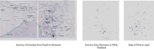
Hand-drawn map of My grand pa and my dad journey from Nepal to Thailand
youtube
Pilok map in 1988
when the second gens of Rama reach in Pilok

during the time mines are starting to close the mines after the official statement of shutting the mine in Pilok
Reverse map to the beginning of Nepalese diaspora in Pilok
Going back to the origin of Pilok. Pilok is a Deserted with no visual boarder line of Burma and Thailand and whole area of Pilok are enrich with mines and minerals.

Timeline of Nepalese Enthonoscape or in Pilok
#pilok#chapter1#NepalesediasporainPilok#Rama'sjourneyacrosscentury#Marielouise Raue#6 tida tida rama#kanchanaburi#phase4
0 notes
Text
PHASE 4 : WELCOME TO OUR UTOPIA
Most commonly cited reasons for moving included weather, followed by health and the desire for “an entirely new way of life spent with others their age” a life conceived in terms of ‘active living’ rather than ‘death’s waiting room’.
Public & Commercial Area.
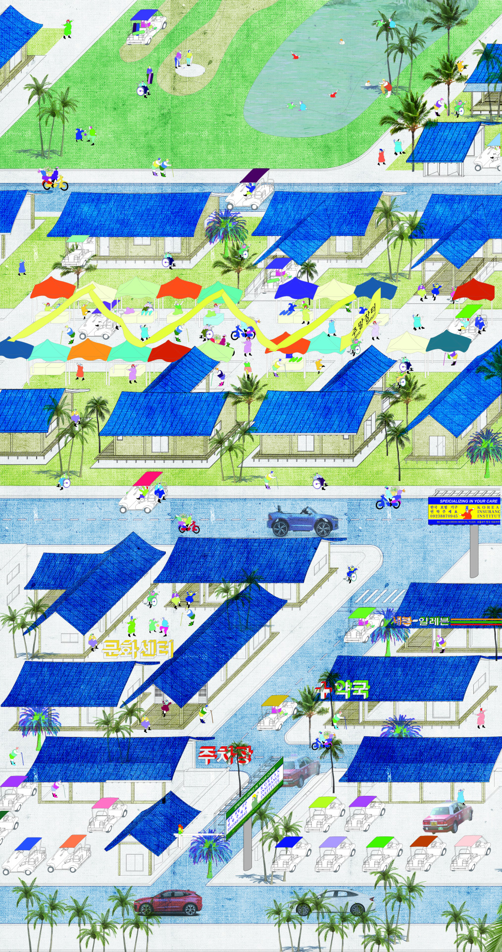
This area is accessible to everyone - tourist, thai people, etc. Not only golf cart but also common car can access here. There are culture center, store, golf course, swimming pool and short rental house similar to airbnb.
Activity area

As this is the town for retirees, there are certain environment that remind them of their memory of past, Retro - style bar, cafe, bookstore is provided, There are also concert of past famous singer.
Medical Area

The Korean medical system and insurance is well known for its convenience and professionality. There is also ‘medical tour. It has driving thru system for less mobile people. Korean traditional medical use herb in their theraphy so that the hospital has their own farm.


0 notes
Text
PHASE 3 : Alternation of Korean House - Hanok

Image of House in Korean Utopia

What defines Korean Town? The signs, food, culture? I thought most important thing is the lifestyle, the house. I started from the Korean traditional house called – hanok, the basic unit of Han-ok is Kan.
It means a space between the two columns, it dividse the function of space.
But even it is a Utopia for Young old, we cannot ignore the aging. I analyze the young old human scale and made a universal unit that fit to every type of old people. Each unit can purpose one function.
The only alternation is the scale.
Alternation of Basic Unit Scale


Various Type of House in Korean Utopia

The characteristic of Han-ok is that it has no limit in extension to horizontal and vertical side. I could create various type of houses.
The terrace called Maru in Korean roles as a hobby space, or community space with neighbor.

But not everyone wants to be a part of social life. I made a hierarchy of solitude.
It starts from 1 house unit and can gather with other under their choice.

Urban Plan of Residence Area - Korean Utopia
0 notes
Photo

Synthetic Mangrove
The synthetic mangrove is a strategy of Silvo aquaculture fishery re inhabiting abandoned shrimp farm to practice the act of poly culture farming. The combination of passive terrain manipulation in parallel with mitigation infrastructure provides a possibility where multi-species native and non native could co exist together in the productive inter tidal landscape of Rayong.

On Monoculture Economy
Located on the Gulf of Thailand, Rayong is known for its rich and diverse marine ecosystem with over 40,000 edible species populating its coastline. However, the province is only known for its famous fish sauce and oyster products. This is because we humans only shortlisted the species we eat, disregarding those unfamiliar to us labeling them as trash or by-catch. Rayong is no different when it comes to production, the productive inter tidal landscape is bombarded with shrimp farms while river deltas are clogged with sediments deposition from oyster farming.

The act of mono culture practice, relying on one species to thrive on its own, almost destroyed the economy of artisan fisherman in Rayong. Their way of life has almost no tolerance to change and when unexpected factors happened to them like the construction of Map ta Phut station chasing away the only specie they harvest. They have to rely on donation money from those industrial company to survive.
My project, set out to redefine a new typology of resilience aquaculture practice, inhabiting the concept of polyculture in parallel with “Opportunistic eater” ideology. Opportunistic eater in this case, refers to how the species on our market would also be controlled by the state of the polyculture balance. Dishes such as oysters would be more common during the present of water pollution or sesame crab would dominate the market during nitrate depletion.
The adaptable strategy is divided into four main parts in which each contribute to specified function of the pond from filtration , coexistence, harvesting and assisted evolution.
Biofloc Filtration

The earliest state of transformation exists on the tidal barrier where strategic geotechnical excavation of concrete barrier propels the growth of phytoplankton turning what was once a road into a biofloc filtration system using an organic factor to clean the current acidic pond

The earliest state of transformation exists on the tidal barrier where strategic geotechnical excavation of concrete barrier propels the growth of phytoplankton turning what was once a road into a biofloc filtration system using an organic factor to clean the current acidic pond .

The pattern defined in the biofloc pond reflects the crested terrain ideal for algae growth allowing it to extracts organic waste during the moment of high tide and provides a harvesting space during low tide.

Co-Managed Resident

The once isolated community of artisan fishermen, are joining up together to co manage the ponds. The importance of these fishermen wouldn’t be overlooked due to their knowledge of the dynamic ecosystem. Making them become the main actors who oversee the pond would allow the preservation of their community.

While sediment deposition was proven to be troublesome in monoculture oyster farms, placing it systematically would allow fishermen to control the deposition force of the incoming tidal wave where the vertices of each structural pole would crash against the prevailing wave.

Consequently, allow them to control the size and composition of dune with regard to the gradient of salinity, allowing non-native mangrove species to thrive in the micro seasonality of the central pond


Harvesting
When the productive rearing pond is established, the question we have left is “How do we harvest specific species to control the balance of the pond?”. This is where we once again revisit the intertidal nature of the pond, taking reference to traditional open sea harvest and allow low tides to trap the limited amount of specie according to our control.

The facades of the harvesting infrastructure contribute to the luring of specific species. The rattan panels are aggregation devices controlled daily by fishermen as a reaction to the state of the environment


Alien Specie

Lastly, a successful productive landscape requires constant evolution. What we know as alien species are welcomed into the pond in a controlled manner from ballast water around the world exploiting the nature of Rayong as a seaport. In the synthetic mangrove, alien species are appreciated due to their level of resilience during this period of food deprivation. And we should rethink the “alien” as an entity that actually constructs a new reality and bring a valuable hybridization rather than an invasive species.

Introduction of non-native species are done in a delicate manner passing through a series of fish gates and canals where fisherman could control the interaction between native and non-native species.


Through time, the transformation would spread throughout the coast of Rayong not only redefining what we know as a fish farm but also make us question same species we eat everyday.

1 note
·
View note
Photo


My project problematizes farming practises and questions the notion of GMO and harmful pesticides that can lead to harmful plant pathogens and the spread of chemicals. What happens if crops and plants, farming and plantation are perceived as a spiritual act where plants is the center off all thing.
In the province of Korat many problematizes the modern traditions of farming and attitudes to plants and crops. In the district that my project is located mass production using pesticides and genetically modified crops (GMO) are a standard model in farming. Crops are planted in repetitive monoculture that is harmful for the soil and some say yeld tasteless and harmful produce. Many consumers are sceptical modern farming and research say that pesticides and herbicides, in the same field can serious consequences – the soil becomes used to it, thus needing other types or stronger insect and weed killers. Afterwards, the use of these chemical products damages the land by infiltrating itself in the soil and, at times, is dragged by rainwater into the nearest body of water. These are harsh killers for wildlife and humans. Soon, it will become the loss of biodiversity. The plants are grown for business purposes and that causes the farmers to psychologically perceive the plants as an asset for income, making them care only about the production rate of the plants. The spiritual values of the plants are completely ignored. The farmers should take in consideration the spiritual value and the process of taking good care of the plants that can affect the quality of the production overall.
My project is discussing and playing with the alternative to emerging technologies, pesticides and GMO. I want to propose both the biotic structure and the abiotic structure. Whereas plants need positive factors : light, wind, water and nutrients. The biotic structure will give a good quality of sunlight exposure to the plant in different ways for different types of plants for good photosynthesis. Moreover, abiotic structure will provide the space for plants to stay. I also take in consideration the idea of positive energy for plants, not only giving them quality structure or just a place to stay but also involve growing plants with music, referencing from an experiment on livestock proving that music increases its quality exponentially compared to that of a typical farm. Music will help the plants to relax whereas the vibration frequency of the music acts as a positive factor that can be compared with the wind in their natural habitat. As I found that we talk with animals and some elements, why don’t we talk with plants? Plants are the middle of everything. Plants have intellectual and mental power, even though they don’t have ears but they recognize the vibration. The song that we have open for plants is designed to stimulate plant growth and nutrient absorption which should be an “ultra high frequency song.”
My proposal structure is the “spritual biomimicry”that duplicates the relationship of ecosystems from the real world. Whereas the plant will get the quality of life from the relationship between plant and structure itself. The biotic structure will control the degree of sunlight that provides for plants to photosynthesis differently. It affects the increase of productivity for farmers to sell to the customer. Inside the structure it provides the space for any kind of plant in which they could live together. It gives the benefit for both plants and humans called “Protocooperation” is where two species interact with each other beneficially.
With the gathering of many species of plant it would create the protocooperation situation. For instance, some plants that enjoy full sun would give shade for shade-loving plants and some plants would provide the moisture to the other plant. Humans and plants are becoming Protocooperation as well, whereas the plant will provide shade for humans, releasing oxygen and producing a high quality product for them. Also it provides a variety of choices for the plant to mating, whereas the plant will get the mix of pollination and cross pollination from this situation. With all these it helps the environment to be more diverse that soon it will create “biodiversity”.
Also I imply the transcendent element into the structure to hallucinate the plant to never want to leave the place. Whereas the structure design for plants to have their own private space and shared space in psychedelic form.

youtube
0 notes