#Cartography
Explore tagged Tumblr posts
Visit Tumblr Blog
Explore Tumblr blogs with no restrictions, modern design and the best experience.
Last Seen Tumblr Blogs


Fun Fact
28.6 is the average number of monthly visits per US mobile user.
Text
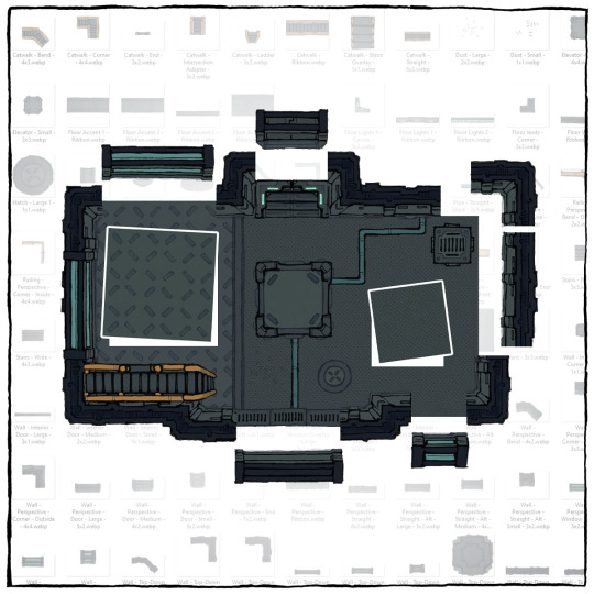
The SCI-FI BUILDING Textures & Assets
Hey, map-maker! I've just published 92 more map assets – they're sci-fi, but perfect for your steampunk and ancient-tech-ruins too! ;)
→ Add these to your collection!
#ttrpg#tabletop#dungeons and dragons#dnd#dungeons & dragons#d&d#d&d5e#pathfinder#gurps#rpg#top-down#battle map#map#cartography#encounter#geomorph
52 notes
·
View notes
Text
Version 11.5, Planet Popstar World Map


— Added a few caves from existing stages of Kirby levels here and there
— Downsized existing structures to make the map feel more bigger in comparison..
— Added transparent cloud background to Floralia to make it more apparent that they're floating islands.
— Added cyan waters to some places here and there to match with their appearance in their respective games? I suppose.
— A few locations like Iceberg and Quiet Forest(the location where 64's Pop Star takes place in) are made accurate to their game appearance!
— Cookie Country has more details
— Kirby Battle Royale locations are added! Apple Scramble Forests and Fenced Forest, Battle Arena, Ore Expressways and Twisty Tunnels yadda yadda.
I think that's all the changes that have been made
Enjoy!
(Version 11 is on Reddit)
#art#digital art#fanart#fanmade#fantasy map#map#mapping#kirby series#kirby fanart#kirby#planet#planet popstar#popstar#pop star#fanmade map#world map#cartography
263 notes
·
View notes
Text
Muhammad Ibn Ahmad Ibn Ayyas al-Misri (d. 1523/4 AD), Kitab ‘ajaib al-akhbar li-khutat misr al-amsar (a historical and geographical work on Egypt), copied by the author, Egypt, dated 925 AH/1519 AD (Sotheby's)
153 notes
·
View notes
Photo
NEW Instagram account: @mariolanzaspeciosus

JURASSIC Period World Map (old cartography style)
This map is inspired in old cartopgraphy, presenting the animals that lived at that time in a stylized way, just as a medieval artists would had drawn them. Three more maps for the Cretaceous,Triassic and Permian periods are also available
this artwork is available fopr prints, t-shirts and much more here
find me on Instagram: @mariolanarensis
412 notes
·
View notes
Text
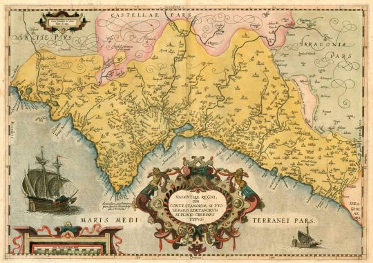
This is the earliest known map of the Kingdom of València (what nowadays is the Valencian Country). It was printed in 1584 by the Flemish cartographer Abraham Ortelius.
The map doesn't represent the North on top, as we're used to nowadays. On this map, the North is on the left, with the Mediterranean sea (the East) at the lower part.
The title, written in Latin, means "Of the Kingdom of València, in the Ancient times [called land of] the Contestans, according to Ptolemy, and of the Edetans, according to Pliny", citing two of the ancient peoples who had lived here until the Roman conquest.
The map was made for commercial purposes, because atlases had become very popular in the 16th and 17th centuries and most rich families wanted to own atlases with maps from all over the world. The Early Modern period in Europe is characterized by this interest in learning about the world, paired with a boom in international commerce and travel books.
Abraham Ortelius, who made this map and many other maps of places around the world, had likely never been to the Kingdom of València. According to cartography historians, this map is most likely based on the notes and hand-drawn map that had been made by the Valencian geographer, mathematician, engineer, and linguist Jeroni Muñoz (1520-1591). Muñoz had been commissioned by the viceroy of València to make a map for military purposes, but sadly that map has been lost.
Sources: Josep Vicent Boira, commissioner of the exhibition Mapes, poder i territori, interviewed in El Temps. Higher resolution image from Saó.
#història#país valencià#mapes#history#cartography#geography#flandes#other countries#belgium#bèlgica#early modern#early modern history#european history#16th century#baroque
23 notes
·
View notes
Text
"Hidden supernatural world" RPG with an ostensibly contemporary setting where the boundaries on the illustrated map in the setting lore chapter's section on global politics clearly depict an extant Austro-Hungarian Empire. This is never addressed in the text.
6K notes
·
View notes
Text
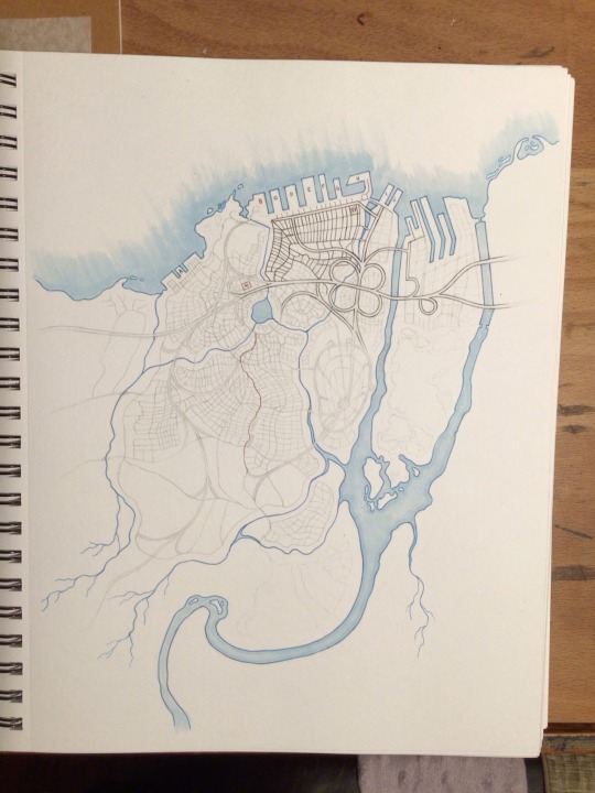
MAPPING REVACHOL (2.0)
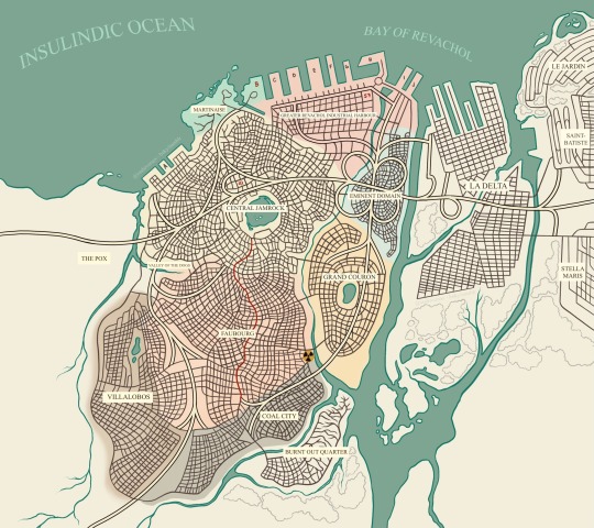
Back in July of 2024, I was incredibly inspired by the project Mapping Revachol by Map Max and wanted to continue on with an attempt of my own. The canon map we're given felt out of date and more than a little incongruous with what we're told in-game, and being both an avid fanfic writer and compulsive visualizer, I really wanted to be able to see Revachol in my mind's eyes.
So, taking inspiration from both Map Max's attempt, as well as meticulously combing through in-game dialogue (with the help of my intrepid friend and far more meticulous researcher than I, @spine-y) we scoured Fayde for any and all directional references to the different districts of Jamrock, East and West Revachol, and everything that lay beyond. (Shoutout to the MoralIntern questline, that one came in clutch).
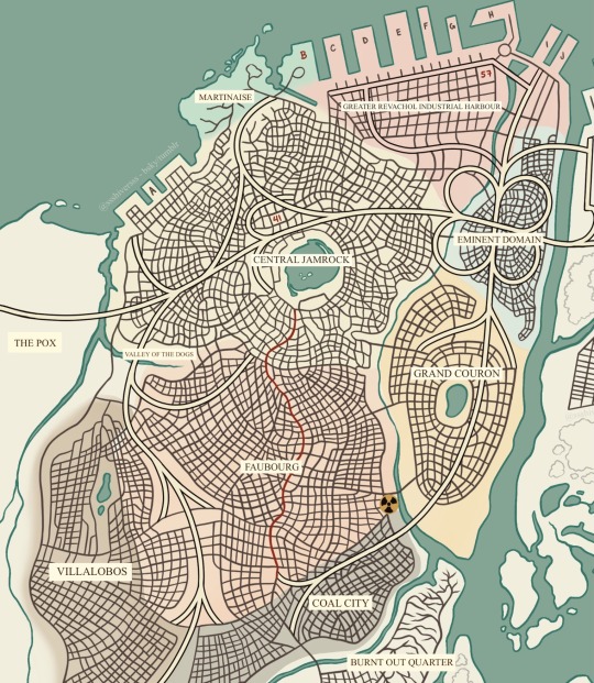
I took a few liberties with district placement, especially because the wiki also seems to contradict a few things we're told in the game. You may not agree with my choices, and I'm open to suggestions! I may not make any changes anytime soon because this took forever, but I also welcome any other attempts to map Revachol!
(The red line that cuts through Central Jamrock and Faubourg is Boogie Street!)
Included below is my initial sketch before I realized that doing this in markers and microns would actually be the death of me, and then some of the early screenshots of trying to figure out what the hell the 8-81 would actually look like and how to make it make sense.

Does it make perfect sense? No! I'm not a cartographer; I'm a fanartist. I'd much rather draw men dicking each other down nasty style. But this was an incredibly fun project that only took me... only six months to complete.
I hope you enjoy!
--
I NEED YOU. YOU CAN KEEP ME ON THIS EARTH. BE VIGILANT. I LOVE YOU.
2K notes
·
View notes
Text

uh oh sisyphus!!!!
481 notes
·
View notes
Text
What did people in Medieval Spain understand about the rest of the world? The Catalan Atlas, one of the great maps in world history, gives us a sense.

There are accurate geographical depictions of the Mediterranean and Europe...

Combined with guesswork and mythology about farther-away parts of Asia and Africa. It’s a world in which dead kings still rule in Africa, Alexander the Great faces off against Satan in Asia, and mermaids lurk off of the southern coast of China.

But it’s also an artwork of great beauty, with hundreds of fascinating details. Come on a tour of the world as it appeared to European mapmakers in 1375!
339 notes
·
View notes
Text

This projection distorts both area and direction, but preserves Melbourne.
Bad Map Projection: The United Stralia [Explained]
Transcript Under the Cut
Above the map: Bad map projection #102: The United Stralia. A 50/50 US/Australia blend
[A map whose left side looks like that of Australia and whose right side looks like that of the United States, with Tasmania swapped out for a supposed island that looks like South Florida.]
827 notes
·
View notes
Text

map time
#MAP TIME!!!!!!!!!!!#warrior cats#warrior cats map#oc map#cartography#rp map#i love doing these these make me so happy :)
158 notes
·
View notes
Text
Guards & Soldiers – Premade NPCs
Need some muscle for your fantasy towns? Grab 30+ ready-made guards & soldier NPCs, complete with art and backstories!
→ Simply grab them here!
#ttrpg#tabletop#dungeons and dragons#dnd#dungeons & dragons#d&d#d&d5e#pathfinder#gurps#rpg#top-down#battle map#map#cartography#encounter#geomorph
45 notes
·
View notes
Text
Map of the Solar System from Signalis

#signalis#maps#cartography#imaginary maps#mapmaking#worldbuilding#fallout#science fiction#scifi#scifiart#outer space#solar system#space
664 notes
·
View notes
Text

A fully inked eagle map!
I like doing the silhouette and turning it into something with ink. It's challenging creatively, and technically easier than my more detailed maps during times when I don't get a lot of time to devote to art.
#my art#cartography#map#my artwork#bluebird art#painting#my maps#watercolor#map making#maps#noai#no ai#not ai generated#eagle#murrica#America#bird#birb#birdie#freedom#mountians#seas#mountain#sea#green
402 notes
·
View notes
Text
FREE MAPS
Today's PSA about resources from the federal government that you might not know about: virtually all of the USGS's maps are in the public domain and free to download. More than a century's worth of them. They even have a nice map-based browser so you can search by location and filter by date, scale, etc. You can also generate your own topo map using the best available data for whatever area you define (within the US) using the topoBuilder application.
You can ALSO get printed versions for quite a low price - I just got one for my office for $9 plus shipping, which came to ~$15 total, I think.


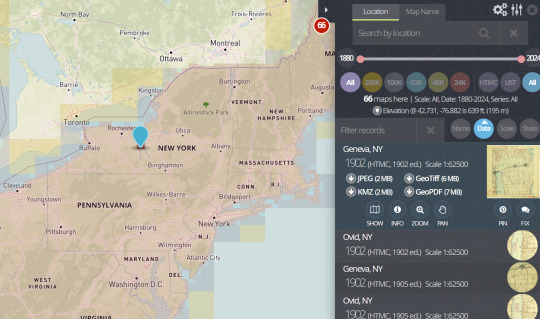
SO if for INSTANCE you wanted a cool old map for your wall and you went to Etsy and found some schmuck selling reprints of old USGS maps for +$50 bucks - THEY'RE SCAMMING YOUUUUUUU they are depriving you of your American right to life, liberty and the pursuit of topographic data
#can you tell i'm mad#maps#cartography#topography#usgs#information#free stuff#get your taxpayer dollars' worth#federal government#federal resources
387 notes
·
View notes