#Software Construction
Explore tagged Tumblr posts
Visit Tumblr Blog
Explore Tumblr blogs with no restrictions, modern design and the best experience.
Last Seen Tumblr Blogs


Fun Fact
When “GIF” was named word of the year in 2012, Oxford Dictionaries U.S.A. credited Tumblr for pushing the word.
Text
Discover how Artificial Intelligence is transforming the entire software development lifecycle (SDLC) — from requirements gathering to deployment and maintenance. In this article, we explore how AI tools boost productivity, enhance quality, and reshape the way teams build modern software. Learn how developers and organizations can harness AI as a powerful collaborator in creating faster, smarter, and more reliable applications.
#AI#Architecture Analysis#Artificial Intelligence#Automated Testing#Coding Phase#Design#Detailed Design#Operating Software#Requirements Elicitation#SDLC#Shifting Left Security#Shifting Left Testing#Software Architecture#Software Construction#Software Deployment#Software Development#Software Development Life Cycle#Software Development Process#Software Engineering#Software Maintenance#Software Retirement
0 notes
Text
So what the hell is up with Luminance?
*crawls in covered in dirt from trying to catch up on the story* I can't find anything lorewise for it really, Liv never uses it ever in the Main Story while the rest of Gray Raven gets upgrades and keep them. I'm honestly curious, are there any loreheads that can explain this to me?
#punishing gray raven#pgr#liv luminance#like i get that constructs swap frames due to mind overload shenanigans#or software issues#but as far as i can find for thisframeits just a ghost
12 notes
·
View notes
Text

UK 1987
#U1987#PALACE SOFTWARE#OUTLAW PRODUCTIONS#SENSIBLE SOFTWARE#ACTION#CREATIVE#AMIGA#ATARIst#C64#SHOOT EM UP CONSTRUCTION KIT
26 notes
·
View notes
Text
Staff Management Software
Prestart’s Staff Management Software streamlines scheduling, enhances communication, and simplifies payroll processing. It offers real-time performance tracking, ensures compliance with labor laws, and empowers employees with self-service features, boosting overall productivity and satisfaction.
#prestartr#fleet management software#project cost tracking software#civil construction management software
3 notes
·
View notes
Text
#erp software#erpnext module#erp implementation#businesssolutions#crm software#erp system#cement#construction
2 notes
·
View notes
Text
At CivilGuidelines, we understand that the process of reinforced cement concrete (RCC) slab casting can be a challenging and complex process. That is why we have put together this brief guide to help you better understand the process and make informed decisions when selecting a contractor for your next project.
1. Preparing the Site
The first step in the RCC slab casting process is site preparation. The site must be levelled and compacted before the work can begin. This is to ensure that the foundation is strong enough to support the weight of the slab. In some cases, excavation may be necessary to remove any obstructions or to reach the desired depth for the foundation.
Read more
2 notes
·
View notes
Text

Some more concept designs but this time for two guys I’ve never talked abt before oops
#keese draws#rain world#rain world oc#iterator oc#rw iterator#rain world iterator#these two are still mostly in the brainstorming phase but I do enjoy them#they share a structure and are also the worst <3#and by that I mean after the mass ascension they eventually start doing some mafia shit#synch started developing ways to carry out construction and repairs and such to the twos structure along with some renovations#the big one being to join the twos chambers so they can actually physically interact#and this gave light some ideas of ways to make sure the two would have access to enough resources to thrive long term#so they and synch worked together to develop different ways of transporting goods and supplies long distance mostly through organisms#and eventually as their fellow iterators began to slowly break down light started offering synch’s services to them#they’d use the chance to get all sorts of data scraping software into other iterators along with all sorts of other shit#and they’d use their newfound leverage over these iterators to blackmail them into giving up their resources for them and synch#often times at the threat of direct structural sabotage that they would follow up on if the iterator didn’t comply#synch is vaguely aware of the stuff that light is doing but doesn’t rly care that much since she rarely talks to other iterators#synch just wants light to be happy and would let her get away with pretty much anything
5 notes
·
View notes
Text
Construction Project Management App

#builders#construction site#contractors#software#house building#app#construction project management#project management
2 notes
·
View notes
Text
4th Quarter Technologies (4QT) offers advanced Construction Purchase and Store Management Software Solutions designed to streamline and optimize the procurement and inventory management processes in the construction industry. These solutions cater to the specific needs of construction companies, helping them manage resources efficiently, reduce costs, and enhance overall project management.
2 notes
·
View notes
Text
instagram
Software Engineer 🆚 Product Designer ? 👌🤑#engineering#software#designer
. . . #programminglife#code#coding#codinglife#mechanicalengineering#construction#engineeringstudent#electricalengineering#civilengineer#tech#memes#i#hendisli#engineerlife#engineeringmemes#design#electronics#civilengineers#innovation#civil#electrical#architecture#manufacturing#engineersday#science#worldofengineering
#engineering#software#designer#programminglife#coding#mechanicalengineering#construction#engineeringstudent#electricalengineering#electronics#worldofengineering#Instagram
4 notes
·
View notes
Text
How CAD Technology Transforms Accuracy and Efficiency in Land Surveying

Land surveying is a critical process in the fields of construction, engineering, and land development. It involves measuring and mapping the terrestrial or three-dimensional space to determine boundaries, land features, and property lines. Traditionally, land surveying relied heavily on manual techniques and rudimentary tools, leading to time-consuming and often error-prone results. However, with the advent of Computer-Aided Design (CAD) technology, the landscape of land surveying has transformed dramatically. CAD has brought about significant improvements in accuracy and efficiency, revolutionizing the industry. In this blog post, we will delve into the various ways CAD enhances land surveying and explore its benefits in detail.
The Role of CAD in Land Surveying
CAD, or Computer-Aided Design, is a technology used for creating, modifying, analyzing, and optimizing designs. In the context of land surveying, CAD software helps surveyors create detailed and precise maps and plans of land areas. The integration of CAD in land surveying involves the use of specialized software that allows surveyors to input data, process measurements, and generate accurate digital representations of physical spaces.
Enhanced Accuracy
One of the most significant advantages of CAD in land surveying is the enhanced accuracy it provides. Traditional surveying methods often involved manual calculations and hand-drawn maps, which were susceptible to human error. In contrast, CAD software offers tools that automate many of these processes, reducing the likelihood of mistakes. Here are some ways CAD improves accuracy:
1. Precision in Measurements: CAD software can handle and process complex mathematical calculations with precision. Surveyors can input raw data collected from the field directly into the software, which then accurately converts these measurements into detailed maps and models. This eliminates errors associated with manual data entry and calculation.
2. Detailed and Scalable Maps: CAD allows for the creation of highly detailed and scalable maps. Surveyors can zoom in and out without losing accuracy, enabling them to examine specific areas closely and ensure every detail is accounted for. This level of detail is crucial for identifying potential issues and making informed decisions.
3. Real-Time Data Processing: Modern CAD software can process data in real time, providing surveyors with immediate feedback. This capability allows for quick adjustments and corrections in the field, ensuring that the final survey is as accurate as possible.
4. Integration with GPS and GIS: CAD software often integrates seamlessly with Global Positioning System (GPS) and Geographic Information System (GIS) technology. This integration allows surveyors to import precise location data directly into their CAD models, further enhancing accuracy and providing a comprehensive view of the surveyed area.
Increased Efficiency
Efficiency is another key area where CAD excels in land surveying. The traditional surveying process was labor-intensive and time-consuming, often requiring surveyors to spend days or even weeks in the field. CAD technology streamlines many aspects of this process, leading to significant time savings and increased productivity. Here’s how CAD boosts efficiency in land surveying:
1. Automated Data Processing: CAD software can automate many of the repetitive and time-consuming tasks involved in land surveying. For example, it can automatically generate contour lines, calculate areas and volumes, and create cross-sections. This automation reduces the workload on surveyors and speeds up the overall process.
2. Simplified Data Management: Managing large amounts of data can be challenging, especially in large-scale land surveying projects. CAD software offers robust data management tools that allow surveyors to organize, store, and retrieve data easily. This simplifies the workflow and ensures that all information is readily accessible when needed.
3. Collaborative Capabilities: CAD software often includes collaborative features that enable multiple team members to work on the same project simultaneously. This collaborative approach enhances communication and coordination, leading to faster completion times and fewer misunderstandings.
4. Efficient Fieldwork: With CAD, surveyors can use mobile devices and specialized equipment to collect data in the field more efficiently. This data can be uploaded to the CAD software on the go, reducing the need for repeated site visits and minimizing downtime.
Visualization and Analysis
Visualization and analysis are critical components of land surveying, and CAD technology excels in these areas as well. The ability to create detailed visual representations of surveyed areas and perform in-depth analyses is invaluable for surveyors, engineers, and developers. Here are some ways CAD enhances visualization and analysis:
1. 3D Modeling: CAD software enables surveyors to create three-dimensional models of land areas. These 3D models provide a realistic representation of the terrain, allowing for better analysis and planning. Stakeholders can visualize the land’s topography, identify potential challenges, and make informed decisions based on accurate data.
2. Overlaying Data: CAD allows for the overlaying of different types of data on a single map. For example, surveyors can combine topographical data with utility lines, property boundaries, and environmental features. This comprehensive view helps in identifying potential conflicts and planning accordingly.
3. Simulation and Scenario Planning: CAD software can simulate various scenarios and predict their outcomes. For instance, surveyors can model the impact of construction on a particular area, assess potential drainage issues, or analyze the effects of environmental changes. This capability aids in proactive planning and risk management.
4. Detailed Reports and Documentation: CAD software can generate detailed reports and documentation based on the surveyed data. These reports can include measurements, calculations, maps, and 3D models, providing a comprehensive overview of the surveyed area. Such documentation is essential for legal, regulatory, and planning purposes.
Cost Savings
The improvements in accuracy, efficiency, and visualization brought about by CAD also translate into significant cost savings. By reducing errors and streamlining processes, CAD helps surveyors and their clients save money in various ways:
1. Reduced Rework: Accurate surveys mean fewer mistakes and less rework. Errors in traditional surveys often led to costly revisions and delays. CAD minimizes these errors, ensuring that the project stays on schedule and within budget.
2. Optimized Resource Allocation: Efficient data processing and management allow surveyors to optimize the use of resources, including time, labor, and equipment. This optimization leads to cost savings and better project management.
3. Minimized Site Visits: With the ability to process and analyze data remotely, CAD reduces the need for multiple site visits. This not only saves time but also reduces travel and labor costs.
4. Improved Decision-Making: Accurate and detailed surveys provide valuable insights that aid in decision-making. This leads to better project planning, fewer unforeseen issues, and more efficient use of resources, all of which contribute to cost savings.
Future Prospects of CAD in Land Surveying
As technology continues to advance, the role of CAD in land surveying is expected to grow even more significant. Emerging technologies such as Building Information Modeling (BIM), drones, and LiDAR (Light Detection and Ranging) are being integrated with CAD software, further enhancing its capabilities. Here are some future prospects for CAD in land surveying:
1. Integration with Drones: Drones equipped with high-resolution cameras and LiDAR sensors can capture detailed aerial imagery and topographical data. This data can be imported into CAD software for precise mapping and analysis. The use of drones reduces the time and effort required for fieldwork and provides access to hard-to-reach areas.
2. Building Information Modeling (BIM): BIM is a digital representation of the physical and functional characteristics of a building. Integrating BIM with CAD allows for a seamless transition from land surveying to construction planning and management. This integration improves collaboration between surveyors, architects, and engineers, leading to more efficient project execution.
3. Augmented Reality (AR) and Virtual Reality (VR): AR and VR technologies can enhance the visualization capabilities of CAD software. Surveyors and stakeholders can use AR and VR to explore 3D models in an immersive environment, gaining a better understanding of the terrain and potential challenges. This immersive experience aids in decision-making and improves communication.
4. Artificial Intelligence (AI) and Machine Learning: AI and machine learning algorithms can analyze large datasets quickly and accurately. When integrated with CAD, these technologies can automate complex analyses, identify patterns, and predict potential issues. This capability enhances the efficiency and accuracy of land surveying.
Conclusion
CAD has revolutionized the field of land surveying by improving accuracy, efficiency, and visualization capabilities. The precision and automation offered by CAD software reduce errors and streamline processes, leading to significant time and cost savings. As technology continues to evolve, the integration of CAD with emerging technologies such as drones, BIM, AR, VR, and AI will further enhance its capabilities, making land surveying even more efficient and accurate. For surveyors, engineers, and developers, embracing CAD technology is not just an option but a necessity for staying competitive and delivering high-quality results in today's fast-paced and demanding environment.
#Land Surveying#outsource cad drafting services#Surveying#Land Survey#Land Surveying Software#Land Survey Drafting Services#Land Survey CAD Drafting Services#Alta Survey#Subdivision Plats#Title Survey#Pipeline Surveys#Construction Survey#Site Planning Survey#Boundary and Location Survey#Topographic Survey#Residential Mortgage Survey#Tower Survey#Radius Map#Utility survey
2 notes
·
View notes
Text

UK 1987
#UK1987#PALACE SOFTWARE#OUTLAW PRODUCTIONS#SENSIBLE SOFTWARE#ACTION#CREATIVE#AMIGA#ATARIst#C64#SHOOT EM UP CONSTRUCTION KIT
17 notes
·
View notes
Text
#builder#construction management#construction toys blocks toy#construction tools#construction time again#construction software#construction technology#construction site#construction services#construction materials
2 notes
·
View notes
Note
Do you also read fanfictions? I am writing one but since English is not my mother language, I am afraid to actually post it lmao. Could you read? See if there's any grammar mistakes and if it flows naturally as it should. But if you cant, dont worry. I totally understand
hii, i don't really do beta reading/editing, sorry!! i can suggest some helpful tools, though, such as grammarly or instatext -- i've used both myself, and they're great! instatext requires a subscription, but you get a free trial period and can edit small portions of text for free every day
and if you think you'd prefer a person to read through it for you, you can always make a public post on tumblr, and ask if anyone would be interested!!!
regardless, have confidence, love!!! you're doing great 🤍🤍🤍
#ask#anonymous#english is not my first language either so i've probably tried out every free text-editing software available#just to see if i'm using an excessive amount of words (i am) and if it's possible to reduce them (it is but sometimes i don't want to)#so explore these options but always believe in yourself!!!#i personally have always loved books from non-english writers even though i usually read the english translations#because often if the english translation is good and stays close to the original text#then the book includes phrasings and grammatical constructions that come from the writer's native language#and therefore they're new to me!! and listen i read a lot and i see a lot of cliches#so to read a text with unusual and not overused expressions is so refreshing and inspiring!!!#i guess what i'm saying is don't be afraid if you can't express yourself like a “true native speaker”#because that can be exactly what makes your writing special!!#no shade to the native speakers though like damn good for y'all we out here fighting for our lives 🫠
2 notes
·
View notes
Text
Construction Equipment Tracking Software
Prestartr's construction equipment tracking software provides real-time monitoring and management of your fleet, ensuring efficient operations, cost savings, and enhanced productivity. Learn more about how our software can streamline your equipment management at Prestartr.
2 notes
·
View notes
Text
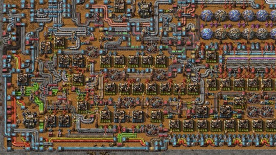
Top 47K - Factorio
Join the HG101 gang as they discuss and rank a construction and management sim by Czech studio Wube Software.
#hardcore gaming 101#podcast#top 47858 games of all time#factorio#wube software#construction and management sim#building sim#microsoft windows#nintendo switch#video games
4 notes
·
View notes