#ancient map
Explore tagged Tumblr posts
Visit Tumblr Blog
Explore Tumblr blogs with no restrictions, modern design and the best experience.
Last Seen Tumblr Blogs


Fun Fact
Users from the US are the majority of Tumblr visitors.
Text
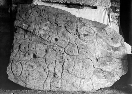
Europe’s Oldest Map: The 4,000-Year-Old Saint-Bélec Slate
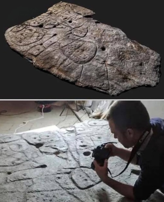
The Saint-Bélec slate, dating back 4,000 years, is considered the oldest known map of Europe.
Discovered over a century ago in northwestern France, the slab remained forgotten until its rediscovery in 2014.
By analyzing local waterways and the positions of ancient architectural sites — especially megaliths — researchers determined that the map represents an area of approximately 630 square kilometers.
This ancient map has already guided scientists to several archaeological discoveries.
The slate itself is massive, weighing between 1.5 and 2 tons, measuring 2 meters in length, 1.5 meters in width, and 15 centimeters thick.
#Saint-Bélec Slate#oldest known map of Europe#oldest known map#map#europe#megaliths#slate#slab#ancient map#archaeological discoveries#archaeology#ancient history#ancient civilizations
8 notes
·
View notes
Text
Saint Belec Slab | Oldest 3D Map in Europe
5 notes
·
View notes

Text
2 notes
·
View notes
Text

Ancient map- Clementoni 2000 pieces
2 notes
·
View notes
Text
#world map#vintage map#compass design#travel motif#explorer pattern#wanderlust#adventure#globetrotter#travel enthusiast#ancient map#world explorer#journey design#travel gift#travel pattern#map pattern
0 notes
Text
Sirius: Please, Reggie, after everything we’ve been through together. You can’t do this!
Regulus: I’m sorry, Sirius
Sirius: I’m begging you, don’t do it!
Regulus: It has to be done.
Sirius:
Regulus:
James:
Remus:
Peter:
Regulus: *places +4* Uno.
#Black brothers are dramatic af#It’s in their blood#black brothers#sirius and regulus#regulus is a little shit#sirius is a little shit#sirius black#Jegulus#wolfstar#marauders era#marauders#the maraunders map#the marauders#the marauders era#the marauders incorrect quotes#marauder era#marauders incorrect quotes#hp incorrect quotes#jegulus incorrect quotes#incorrect wolfstar quotes#wolfstar incorrect quotes#regulus and sirius#sirius orion black#regulus black#regulus arcturus black#remus lupin#james potter#peter pettigrew#the black brothers#the most ancient and noble house of black
683 notes
·
View notes
Text
Lanky, awkward eleven year old Remus, who fully planned to spend the next seven years avoiding everyone and keeping his nose in a book.
Eleven year old Sirius, who almost faceplanted on the train because he'd never seen someone that beautiful before
Baby wolfstar 🥰
#marauders era#arcturus speaks#the marauders#marauder era#the marauders map#sirius black#remus lupin#wolfstar#remus x sirius#sirius orion black#remus loves sirius#sirius loves remus#sirius and remus#the maraunders map#marauders#the marauders era#dead gay wizards from the 70s#dead gay wizards#the noble house of black#the noble and most ancient house of black
638 notes
·
View notes
Text
Sirius Black who constantly steals Remus's jumpers and cuddles up close to literally anyone if they let him, even during the summer months, because he developed nerve damage from being cruciod too much making him feel permanently cold
Regulus who develops the same thing the day that Sirius leaves.
#aella talks#marauders#regulus black#sirius black#marauders era#the marauders#the marauders map#marauder era#marauders map#maraders era#slytherin#slytherin skittles#sirius black and regulus black#sirius and regulus#the noble and most ancient house of black#the noble house of black#the house of black#the black brothers#black brothers#black brothers angst#regulus black angst#sirius black angst#walburga's a+ parenting
175 notes
·
View notes
Text
Thinking about twelve-year-old Sirius Black speaking out during a Black family dinner and because of this Walburga and Orion refuse to sign the permission slip to allow him to visit Hogsmeade as punishment.
Sirius never being one to sit and do as he's told. Sirius who finds the passage into honey-dukes cellar and uses the invisibility cloak to walk around Hogsmeade without being seen. Sirius laughing and joking with the rest of the marauders before James spots McGonagall. Sirius hiding under a table in The Three Broomsticks so McGonagall doesn't see him.
Harry Potter hiding under the same table listening to the story of how Sirius Black murdered his parents.
#i make myself cry#marauders fandom#the marauders#marauders era#the maraunders map#sirius black#sirius orion black#the noble and most ancient house of black#harry potter#anti jkr
157 notes
·
View notes
Text
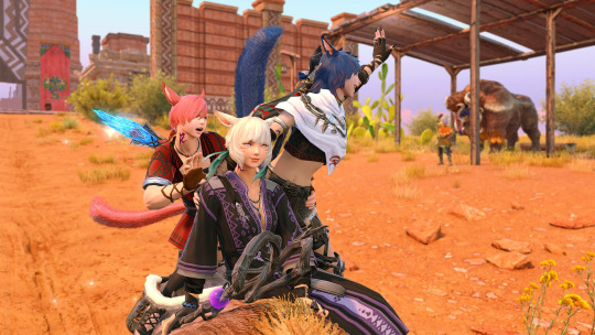
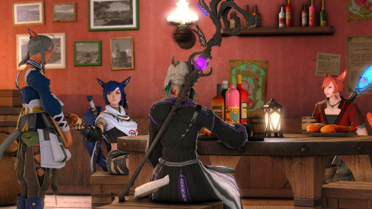


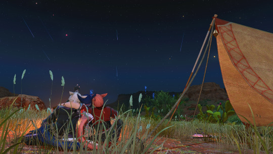
Honeymoon pt.5 - Shaaloani
Aetherically, there are some striking differences; but in form alone the similarities to The Qitana Ravel are uncanny. That such ruins could exist both on the first and the source.... This has given me much to think about. Come, you two, let us freshen up and make camp before nightfall. Our adventures may continue tomorrow.
<<prev//next>>
#ffxiv#ffxiv gpose#wolgraha#wolshtola#y'shtola x wol#y'shtola rhul#g'raha tia#Arsay Nun#graharshtola#dawntrail#dawntrail spoilers#Tent mod is by magic mods on ko-fi#a minor canon adjustment for arsay and the gang#they get into tender valley while trying to do a treasure map lol#my idea here is that estinien and arsay bonded over doing a treasure map so he left one with the bar staff to surprise her with#when she inevitably stopped by#call it a wedding gift i suppose haha#as for the researcher - Arsay will bump into the guy at a slightly later date#the first tender valley image is a reference to my miqomarch2023 quitana ravel gpose set lol i wanted to do a fun call back#arsay just loves old ruins from ancient civilizations she thinks they are so cool!!#and yes I know shes holding her weapons like a viper but then doing a ninja attack its not important#i think making yshtola's dress took as much time as making all these gposes lol#it was worth it tho she's so cute in it#ill take some glamshots of it at some point lol
176 notes
·
View notes
Text

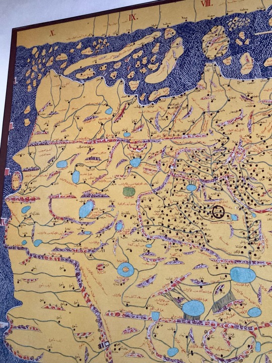
This 1455 map of the Holy Land makes an excellent smartphone wallpaper.📱
2 notes
·
View notes
Text
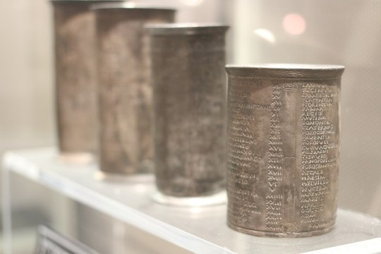
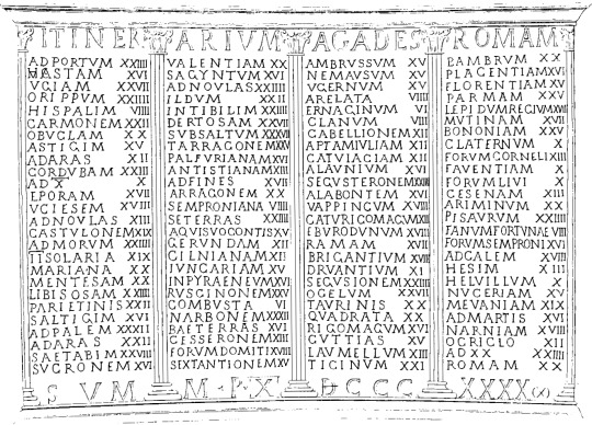
The most common geographical evidence we have from ancient Rome are catalogs of places. Roman maps, to the extent that they existed at all, were almost certainly rare and expensive. Ordinary Romans would not have had access to them. Instead, Romans would have used itineraria, which are just what they sound like — lists of the places a traveler might encounter along a certain road. Many itineraria are catalogs of the milestones that the Roman government placed on its road network.
One of the more famous itineraries is found on a set of cups that were excavated in Vicarello; they describe the route from Cadiz, Spain to Rome.
{WHF} {Ko-Fi} {Medium}
2K notes
·
View notes
Text

Map of Rome
Attribution:
Unknown authorUnknown author (H. Jordan ?), Public domain, via Wikimedia Commons
61 notes
·
View notes
Photo


Representation of the central tenet of the Orion correlation theory: the outline of the Giza pyramids superimposed over a photograph of the stars in Orion's Belt.
300 notes
·
View notes
Text

In ancient Egypt, maps were not as developed or commonly used as they are in modern times. However, the ancient Egyptians did have a basic understanding of geography and utilized certain visual representations to depict their surroundings. These representations were not as detailed or accurate as modern maps but served specific purposes.
One type of map-like representation used in ancient Egypt was called a “topographical list” or “descriptive list.” These lists documented important landmarks, cities, temples, and natural features along with their distances and directions from one another. They were often inscribed on temple walls or tomb reliefs and served as guides for religious or funerary processions.
Another form of representation was the “land register” or “estate map.” These maps depicted agricultural lands, indicating boundaries, fields, canals, and other relevant features. They were primarily used for administrative purposes, such as taxation and land management.
Ancient map of Egypt with names of towns and nomes in hieroglyphs
by Jeff Dahl
Read more
123 notes
·
View notes