#oldest known map of Europe
Explore tagged Tumblr posts
Visit Tumblr Blog
Explore Tumblr blogs with no restrictions, modern design and the best experience.
Last Seen Tumblr Blogs


Fun Fact
Tumblr has 4 main sources of revenue.
Text
Europe’s Oldest Map: The 4,000-Year-Old Saint-Bélec Slate
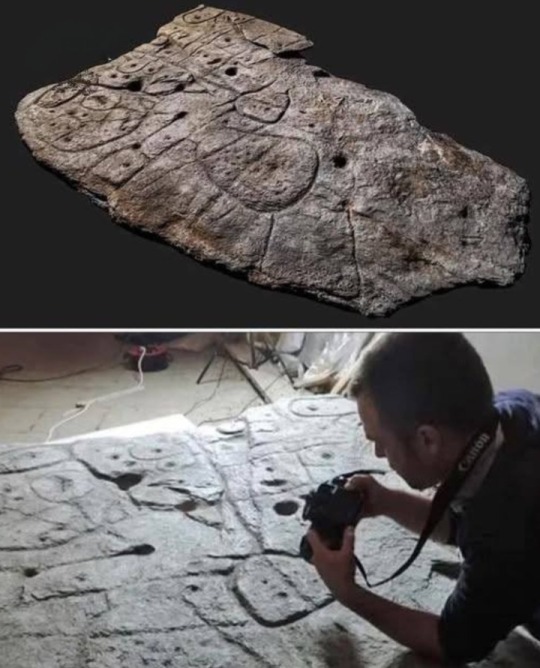
The Saint-Bélec slate, dating back 4,000 years, is considered the oldest known map of Europe.
Discovered over a century ago in northwestern France, the slab remained forgotten until its rediscovery in 2014.
By analyzing local waterways and the positions of ancient architectural sites — especially megaliths — researchers determined that the map represents an area of approximately 630 square kilometers.
This ancient map has already guided scientists to several archaeological discoveries.
The slate itself is massive, weighing between 1.5 and 2 tons, measuring 2 meters in length, 1.5 meters in width, and 15 centimeters thick.
#Saint-Bélec Slate#oldest known map of Europe#oldest known map#map#europe#megaliths#slate#slab#ancient map#archaeological discoveries#archaeology#ancient history#ancient civilizations
8 notes
·
View notes
Text

Mansa Musa: The Richest Man in History Who Changed the World
In the 14th century, long before billionaires walked the earth, an African emperor from Mali commanded wealth so vast it defied imagination—and reshaped economies across continents. Mansa Musa I of Mali, who ruled from 1312 to 1337, is often regarded as the richest person in recorded history, with estimates of his fortune so immense that they are considered incalculable in today's terms.
The Rise of a Golden Empire
Mansa Musa ascended to the throne of the Mali Empire, one of the largest and most prosperous empires in West African history, at a time when Mali was already flourishing. Situated between the West African gold fields and the North African trade routes, Mali was the center of gold production in the medieval world. By the time of Musa’s reign, Mali accounted for nearly half of the world’s gold supply.
Mansa Musa inherited a kingdom that was already powerful, but under his leadership, it reached new heights of economic, cultural, and territorial power. His empire stretched from the Atlantic coast through present-day Senegal, Mali, Niger, and parts of northern Nigeria.
---
The Legendary Pilgrimage to Mecca (1324–1325)
In 1324, Mansa Musa undertook the Hajj, the Islamic pilgrimage to Mecca, a journey that would place both him and the Mali Empire on the world map—literally.
But this was no ordinary pilgrimage.
He reportedly traveled with a caravan of 60,000 people, including soldiers, officials, and slaves.
He brought along 80 to 100 camels, each carrying hundreds of pounds of gold dust.
He was said to have distributed so much gold in Cairo, Medina, and Mecca that the value of gold plummeted, causing inflation that lasted over a decade in some areas.
His generosity stunned the Islamic world and Europe. He built mosques, paid off debts of the poor, and funded public works—all in gold.
This extravagant journey made headlines in the Arab world and Europe. So profound was its impact that Mali was soon included in the 1375 Catalan Atlas, one of the most important world maps of the Middle Ages, with a depiction of Mansa Musa holding a golden nugget and a staff.
---
Timbuktu: A Center of Knowledge and Civilization
Upon returning from his pilgrimage, Mansa Musa was not content with just displaying wealth—he invested it in the transformation of Mali into a global center of Islamic culture, trade, and learning.
Most famously, he developed the city of Timbuktu, which became one of the greatest intellectual centers of the Islamic world. Under Musa’s patronage:
The University of Sankore was expanded—today considered one of the oldest universities in the world.
Scholars, poets, architects, and jurists were brought in from across North Africa and the Middle East.
Manuscripts covering subjects from astronomy to law, medicine to theology, were collected and preserved.
Libraries and mosques were built across Mali, many of which became architectural marvels.
Timbuktu became known as the "City of Books," and its legacy as a center of learning endured for centuries.
---
Cultural and Historical Legacy
Mansa Musa’s reign is a powerful reminder of Africa’s historical greatness—a time when sub-Saharan empires rivaled the finest kingdoms of Europe and Asia. His story disrupts the Eurocentric narrative that Africa was always poor, uncivilized, or isolated from global development.
His wealth wasn’t just measured in gold—it was also evident in the flourishing of arts, education, and religion across Mali. He laid down a legacy of intellectual and spiritual richness that would outlive his material wealth.
---
Why Mansa Musa Matters Today
1. He represents a forgotten African Golden Age—a period of prosperity, innovation, and global influence.
2. He symbolizes the power of vision—a leader who used wealth not just for self-aggrandizement but for building institutions that elevated his people.
3. He challenges modern perceptions of Africa—reminding the world that Africa has been a birthplace of wealth, wisdom, and wonder.
---
Quick Facts
Name: Mansa Musa I (also known as Kankan Musa)
Reign: 1312–1337
Empire: Mali Empire
Famous for: His pilgrimage to Mecca, immense wealth, and development of Timbuktu
Religion: Islam
Estimated wealth: Equivalent of over $400 billion (modern estimates)
---
Conclusion
Mansa Musa’s story is not just a tale of gold and grandeur—it is a reminder that Africa’s past is filled with powerful empires, visionary rulers, and sophisticated civilizations. In an age where the riches of kings are celebrated globally, Mansa Musa’s legacy demands to be honored, studied, and shared.
13 notes
·
View notes
Text
Mezmaiskaya Cave, Russia

Source: https://www.researchgate.net/figure/Map-of-the-Caucasus-showing-the-location-of-Mezmaiskaya-cave-and-Saradj-Chuko-grotto_fig1_364384782
Mezmaiskaya Cave (Мезмайская пещера) is a cave located on a tributary of the Kurdzhips River in the North Caucasus foothills. It shows signs of habitation from 70,000-40,000 years before the present, during the Late Middle Paleolithic era, and by Homo neanderthalensis, including an infant of about two weeks old. This is the youngest H neanderthalensis ever recovered and showed signs of being an intentional burial.

Source: https://phys.org/news/2025-05-ancient-bone-spear-russia-oldest.html
Within this cave, researchers also found a bone spear point of about 9 cm in length that has been recently confirmed to be the oldest known bone point found in Europe. While originally found in 2003, it was only recently studied. It was made from a bison leg bone and was attached to a wooden shaft using tar. This tar was an adhesive compound made through the careful heating of organic matter until it was usable as a glue. This bone point shows signs of being from 80,000-70,000 years ago, putting it at the older end of artifacts found in the cave. This also pre-dates H sapiens in Europe by at least 25,000 years.

Source: https://phys.org/news/2025-05-ancient-bone-spear-russia-oldest.html
In addition to being deliberately created with a conical profile with grooves to improve flight, and hardened in a fire, the point shows minimal use, though it was used in hunting, though it was broken in what was likely its first use. It shows signs of an attempt to sharpen it again by grinding before being discarded near a hearth that was made in the natural hollow of a limestone slab. This allows us to understand something of the lives of H neanderthalensis, that this cave was a long-term workshop where tools were created and animals were butchered.
8 notes
·
View notes
Note
Hi!
Can you tell something about your Brazilian ymbrynes??? It would be interesting to read👀
Of course! I won't talk about them exactly because it would be too long and wouldn't fit in the post, and I intend to make an individual post for each ymbryne (of the seven that I have already presented).
•
I will talk about the government structure (I promise it won't be boring)
The Brazilian council cannot function like the European one, the continental dimensions of the country make the European model unfeasible since just one Brazilian state is the size of an entire European country. So the country needs more loops and that's why the Ymbryne academy trains ymbrynes and Demi-ymbrynes, they work under the motto "one of us creates the loop and the other maintains it" so there is at least one active loop in each state of the country (in larger states like Amazonia and Bahia there are more than one active loop), some containing ymbrynes and others Demi-ymbrynes. Demis cannot take care of children. Their loops are tourist loops, hotel loops, loops for adult peculiars, and sometimes punishment loops. However, all of these loops can only exist with permission from the Ymbryne council and are mapped. Demi Ymbrynes can also go out in search of peculiars and take them to the nearest Ymbryne
•
Okay, now for the fun part:
The Amazon is where the peculiar treasure is found. There are areas that are extremely difficult to access in this area. That's why the loops in this state are the oldest in the country and the most inaccessible, and they are where everything that is most important is kept (like our late Light-eater). These loops are almost impossible to access without the help of an experienced peculiar. There are loops that date back to before colonization, where peculiars were considered gods by indigenous tribes (tribes that should be avoided because of anthropophagy).
The largest loop of Brazilian peculiar fauna is in the Amazon (the second is in the Pantanal), and it is there that many animals that exist in folklore legends live, such as: headless mules, fire-breathing sea serpents, sea creatures and my favorite creature: Yacumama, a gigantic serpent. Wights that invade these lands are usually given as food to the peculiar piranhas, and if they are very unlucky they will be devoured by the Yacumama.
If you are interested in peculiar Brazilian animals, I have drawn and listed some in this post.
•
With a history of hundreds of armed revolts, Brazil has a multitude of punishment loops on various dates, with the worst loops being in:
Goiânia 1987: one of the world's worst radioactive accidents (only those sentenced to death are sent there)
Loop on big burn island : better known as Snake Island , it is an uninhabitable island where the Demi-Ymbryne restarts from a boat far from the coast. No one survives for long on this island because of the unique species of extremely lethal snake that exists on this island in abundance (another loop destined for death sentences)
•
We also have several tourist loops, the best known being Carnival loops (peculiars love these loops. If in Europe Halloween is the best time to be Peculiar, in Brazil it is definitely Carnival, since there are 5 days of parties where you can dress up and any normal person who sees a peculiar person and tells about it will be discredited because people will think this normal is completely drunk).
Loops during the June festivals (mainly on the days of the three saints)
Loops at the Parintins festival.
Among other loops at smaller or more recent celebrations such as Oktoberfest or concerts like Rock in Rio.
•
Because of miscegenation and immigration, Brazil is a great place for peculiar people from any part of the world to fit in and is a great place for refugees from Wight attacks from the rest of the globe. It was a safe zone until Bentham opened a door to the country through his panloopticon and brought the Wight scourge to the country, making life in loops safe only to a certain extent.
•
Well, I think that's enough for now! I hope you like it!
I apologize for the delay in responding, I've been very busy lately and it takes me a long time to prepare a well-explained text about what I want to address.
15 notes
·
View notes
Text

they just discovered an alphabet in the el turuñuelo tartessic site !!!!! this is huge !!!!!!
the tartessic culture is the oldest in the iberian peninsula, located in the southwestern corner of the peninsula and dated to around the 9th century BCE to the 5th/4th century BCE. in this map you can see in the brightest red the core of the culture, in darker red the dispersion to the north in later centuries, and in light red its cultural sphere, which spanned almost half of the peninsula.

if you are interested in the culture, i have a post about them.
el turuñuelo is an archaeological site located in guareña (guadajoz), in the northernmost point of the tartessos culture. it is with no doubt the singlemost important tartessic archaeological site, and i would even go on to say it is the biggest archaeological discovery of this century - at least in europe.
it was discovered in 2015, and it is a sanctuary or some sort of temple complex, which at first made the news because of its incredible state of preservation: a complete set of stairs and the remains of a horse hecatomb with at least 17 complete bodies were found in 2017.
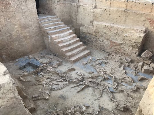
it already was the most important tartessic archaeological site just because of that (there are very few tartessic sites and most of them are not very well preserved), but after the excavations halted during covid, these last few years they returned to the site and they have made amazing discoveries. the most well-known and televised one, that made it to the news and i got to see when they set up an exposition about them last summer, are the faces of el turuñuelo in 2023, the first ever representation of tartessians by tartessians. i made a post about them, if you are interested.

this year they not only found a large collection of tartessic ceramic - which lets us know that the temple was also an artisan and probably commercial center as well, as it was usual in ancient religious centers - but just a few days ago they discovered a slate plaque with human figures, that seem to be a sort of trial drawings made by some artisan

if they seem familiar, that's because it is in one of these plaques where the alphabet has been able to be traced down, being able to be confirmed only today (11/06/2024). this is only the third southwestern paleohispanic alphabet ever founded - an alphabet derived from the phoenician one - and the most recent. it is also distinct from the other two previously discovered ones, seeing some sort of dialectalism in the way this alphabet (or set of alphabets) worked. more importantly, it is the first one to note a tartessic language, which we know was not indoeuropean in nature and also distinct from the iberian languages of the mediterranean coast. this was a distinct language or languages.
this is very exciting not only because we have a tartessic alphabet, but also because we know from greek authors like strabo that tartessians were known to be scholars that had large libraries with all sorts of knowledge of the past. we also know that the greeks interacted with the tartessians. so. it is possible that, if el turuñuelo had one of these archives that strabo talked about, that more writting can be salvaged and not only that, we could find a bilingual text in tartessian and greek that could act as a rosetta stone to finally descipher tartessian, the oldest known language in the iberian peninsula.
i cannot wait to see what el turuñuelo brings us next, it's so very exciting !!!!!!!
#archaeology#tartessos#spain#turuñuelo#i'm so fucking excited man#el turuñuelo is the gift that keeps on living#and not only that#they started to excavate el turuñuelo because they did a survey beforehand and found a series of tumuli along the guareña valley#and fixated in el turuñuelo just cause#but there's more sites like el turuñuelo waiting to be excavated#IMAGINE WHAT WE'LL GET IN THE NEXT YEARS
38 notes
·
View notes
Text
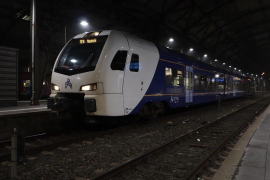
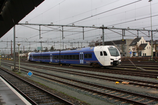
LIMAX
I’m tired, I’m bored, let’s talk about the RE18, also sometimes known as LiMAX or Drielandentrein (three countries train).
Euregio
This international regional train connects the region known as Euregio Maas-Rhine, the area around the point where Netherlands, Belgium and Germany meet. The region has a long shared and sometimes weird history. The main cities are Aachen (Germany, about 260,000 inhabitants), Liège (Belgium, about 200,000 people) and Maastricht (Netherlands, about 120,000 folks). A cluster of smaller towns around Heerlen (Netherlands, 86,000 citizens) forms a fourth major pole. Each of the regions gets roughly around half a million inhabitants each, but with a lot of green space in between. Here's a very crude map:

Blue are borders, black are relevant passenger rail lines, red is the one high speed line I'll talk about later.
This region is either right in the centre of Europe, or at the periphery of each of its respective countries, depending on what aspect you look at. Centre of Europe is undeniably better, but it requires international cooperation to work out. For me, living in Aachen, it’s great. My nearest Ikea is in the Netherlands, and I can watch French movies in cinemas in Liège.
But a lot of things aren't perfect, and the regional rail connections are a good example. Differing ticketing systems mean that it's not only expensive to cross the border, it's often very difficult to figure out what it costs at all. In a lot of places, trains only did short hops over the border, and then you had to change to a different train to get anywhere interesting. Some lines weren't even electrified yet. But in 2018, that was all about to change.
LIMAX
The Liège-Maastricht-Aachen express, in short LIMAX, was meant to change all that. The train is officially known as RE 18, which comes from the numbering scheme in the German state of Northrhine-Westphalia but is used for the entire route. It was supposed to run from Liège via Maastricht and Heerlen to Aachen, connecting all the major cities of the Euregio.
This particular train is a dutch project, and connecting Aachen with Liège only happens incidentally. There is a direct Aachen-Liège railway line, actually the oldest international line that’s still in use, including the oldest surviving German railway tunnel, and there is even a high-speed line that bypasses around 90% of the historic line. You can get from Aachen to Liège in less than half an hour on high speed trains (though regional trains are weird and impractical at the moment). This train line is really more about getting people in Heerlen a direct link to Liège, and people in Maastricht a direct link to Aachen.
The train
The train is operated by Arriva Netherlands Limburg, an independent subsidiary of Deutsche Bahn, who also operate all other rail and bus lines in the southern half of the dutch province of Limburg. They were actually placed second in the tender for this, but got promoted after it turned out that the actual winner Abellio (a daughter of the dutch state railroads NS) had illegal access to internal documents of previous operator and third-place scorer Veolia from France. To their credit, this came out because Abellio management learned of it and made it public, but rules are rules, so they still got disqualified. This is barely in the top three most interesting stories with Abellio, but we don’t have time for that here.
The service uses Stadler FLIRT 3 electric multiple units. FLIRT is an abbreviation, but nobody bothers remembering what it stands for. The manufacturer also offers or used to offer the TANGO (streetcar), the WINK (smaller version of the FLIRT), KISS (double-decker) and their newest high-speed train, the… SMILE. Cowards.
The FLIRTs for this service are specially equipped for the line, supporting all the different voltages in the overhead lines and all the other necessary support systems… almost. That’s going to become important later.
(Arriva Nederland Limburgs also has other trains, including other FLIRTs, that are only equipped for the Netherlands. I'll ignore them here.)
Services started in December 2018, theoretically. In practice the German leg of the service didn’t work yet. The problem was that the line from Heerlen to Herzogenrath (and then further to Aachen) used to be one of the few non-electrified lines in the region. It was electrified specifically for the RE18, and the work wasn’t quite finished yet. That got resolved, though, and the train is now working mostly well between Germany and the Netherlands. There are still some issues, like how it consistently announces that the doors will open on the left when they will open on the right and vice versa, but those are minor issues. The main problem for me is that it bypasses the Ikea station instead of stopping there.
The much bigger problem was the Belgian line, from (south of) Maastricht to Liège. The Belgian railway authorities were never that enthusiastic about the project to begin with, seeing how it was a private dutch company (though owned by the German government), and the platforms in the intermediate station of Visé were too low for step-free access and needed to be rebuilt. But the real main issue lay elsewhere: The new trains did not have ETCS.
Train control systems
We need a detour here about train control systems. Trains are controlled by signals. If a train passes a red signal, an accident usually follows, so over time every country developed different systems to make sure that doesn’t happen. The specific features of these vary widely. Some just warn the engineer that a red signal is ahead, and stop the train if the engineer doesn’t react. Some activate the emergency brake when the engineer passes a red signal, or when they don’t brake enough. More advanced ones for high speed lines tell the engineer the current allowed speed, upcoming speed changes and how far away they are, like a mini-GPS system, and constantly check that the engineer is driving within these limits. Many systems do a combination of different things.
Almost every country has its own of these systems, generally known by a cryptic abbrevation, and many countries have several. For example, Germany has PZB for all lines and additionally LZB for high-speed lines. The Netherlands have different versions of ATB, Belgium has TBL1+ and so on. The differences between them aren’t relevant for this post, but they’re all very different in what they do and how they do it. The RE 18 trains support all of them, except LZB because they’re not used on lines that make it necessary.
That’s expensive and annoying, so the European Union and European rail industries have developed a new system to replace all of them, the European Train Control System or ETCS. You will also hear the term ERTMS (European rail traffic management system), which includes ETCS and some other things, but in common parlance it usually means the same thing. Despite the name, it is also heavily used outside of Europe, e.g. on China’s high speed rail network.
And yes, that is very much a situation like the classic XKCD comic:

Source: XKCD 927, CC-BY-NC 2.5
(For americans reading this and wondering about PTC: That is a whole mess and almost everyone, including Wikipedia, explains it wrong, but for the purposes of this post we can just say that these systems and in particular ETCS are all something „like“ PTC.)
ETCS will only make sense once all European mainlines are equipped with it, which is still several decades away. But some countries are working harder than others to implement it. In particular, Belgium demands that all new trains since about 2015 have ETCS. Including the Stadler FLIRT for the RE 18.
In this case
The operator protested, because that requirement apparently came in while the trains were in production, and the line in question didn’t even have ETCS at the time (according to the latest Belgian maps it does now). To this day, the trains actually running there, as a Liège-Maastricht shuttle, do not have ETCS. So clearly it's not that essential… yet. Still, Belgian authorities refused to budge, so the trains had to be sent back to the manufacturer to get ETCS installed.
(Aside: ETCS is an open standard, and you can get ETCS equipment both for the tracks and for the trains from many different companies. Stadler, the manufacturer of these trains, only recently got into making ETCS equipment. Before that they had to buy it from competing train makers. These trains are among the first equipped with Stadler’s ETCS solution.)
The first train got it installed, returned to the line, and started tests. It worked well in the Netherlands, it worked well in Germany, it ran into Aachen station and worked well there, it ran back out of Aachen station and it stopped. Full emergency stop. After some testing it was determined that it always does an emergency stop when running out of Aachen station. And nobody is really sure why.
The low-down
We can make some vague guesses, though, because Aachen main station does have some ETCS equipment.

ETCS works partially with radio, but also with what are functionally giant RFID tags, the same basic concept like what you’ll find on a wireless credit card. They’re working at different frequencies and they’re designed for reliable reading at 450 km/h, but the basic idea is pretty much the same. These tags, known as „Balise“ (French for beacon) or Eurobalise, are mounted in the middle of the track, and are often yellow, at least when new. They can either send the same data every time, or be controlled with a cable from a computer.
Not everybody loves ETCS, but everybody seems to like the Eurobalise. It’s simple technology that can transmit a lot of information, and so there are a number of non-ETCS uses for it.
One such use case is transmitting the information of an older train control system. That is what the Belgians do with their TBL1+ system. It’s the same system as TBL1 (there is also a TBL2, but that was a bad idea and is gone now), but it transmits its information with Eurobalises. The idea is that you update these balises later to also transmit ETCS signals. Older trains can just get a balise reader, newer trains can just get ETCS, and you have only a single type of thing in the track instead of two. Switzerland is the first country that is fully ETCS equipped thanks to such a strategy, and Belgium is following suit.
The other use case is the "ETCS-based class B transition". Sounds tough but really isn’t: ETCS has a mechanism to tell the train, "hey, ETCS is ending, switch to ATB/PZB/TBL/…". In this context "Class B" means any system that isn’t ETCS (and that is on the list of things that ETCS knows about, for this purpose). The system ensures that the train really does switch to the other system, and that it stops if the switch doesn’t work. That is very useful and so most border crossings at least in Germany use it these days, even if no other part of ETCS is seen anywhere.
Both of these use cases are well established and ETCS specifically allows for them. Aachen central station is particularly fun because here you will find both of them combined. It is the border station for (passenger) trains to Belgium, so several tracks can be switched to Belgium mode, with Belgian electricity, and with Belgian TBL1+ train control system. The Eurobalises in these tracks pull double duty: They tell trains whether to switch to Belgian or German train control systems, depending on where the route is set, and if the Belgian system is to be used, they also transmit the information from that.
This isn’t new, and has worked well for years. The only other two types of passenger trains approved for the Netherlands, Belgium and Germany (and in one case also France), the Thalys PBKA and the ICE 3M high speed trains, also run through this station and they also have ETCS equipment and it all works.
But something about the combination together with the ETCS equipment in the new trains just doesn’t mesh well. It’s possible that there’s a bug in the software of the train. It’s possible that there’s a bug in the coding of the balises. Maybe it's something else; ETCS is a complex standard with a lot of updates, and the equipment in Aachen hasn't been touched in a while.
A theory I read on a dutch forum said that these balises tell the train to switch to combined PZB+LZB mode, but the train only has PZB mode and gets confused. I don’t know enough about ETCS to know whether this is plausible (and I know way too much about this stupid system already). All we really know for sure is that there are people working on this, and they're not telling us any of the details.
But after a few days where the train just didn’t run to Aachen at all, they found a solution. You know how I said that some tracks can be switched to Belgium mode? The others can’t, so why not just run the train into those?
That was actually easier said than done. Aachen has a lot of tracks, but most of them are used for parking trains. Most German regional trains to Aachen end in Aachen, and then wait here for half an hour or so until they return to where they came from. This isn’t required by the track layout or anything, it’s just convenient because that way, delays don’t build up quite as much. And the best location for that pause is, of course, right at the edge of the country. Centre of Europe? Yeah, sure, whatever…
So the solution is now that the RE18 runs into track 3 and stops in the middle of the platform, where it unloads all passengers. Then it drives forward to the end of the platform, and stays there. Another train, the RB33, pulls in behind it (there’s a red signal between them, don’t worry), and waits for its time to depart. Eventually it does, and shortly thereafter, the RE18 runs back to the middle of the platform, and then a few minutes later, back out again. It’s a silly little dance, but so far nobody has found a better solution.

(Before you start, the end of platform 3 is very narrow and at a non-accessible height, so the train can't just load and unload there.)
As for the Belgian side of things, through-services to Liège will start this December! Woohoo! It seems this thing is finally working.
The Future
The long-term hope is to turn this from an hourly to a half-hourly service. It already is for most of its length, but right now the trains stop in Herzogenrath, just after the German border, because there is no space in the schedule to run them to Aachen yet.
Another hope is to create a completely new service from Aachen to Eindhoven, also using the same trains. Eindhoven wants to be connected to the German ICE network, Aachen wants to be connected to the dutch train network, so this sounds all great. Personally, I have doubt that these trains have enough capacity, but they are currently the only ones that would work. An issue with that is the actual line over the border. This used to be double-tracked, then got single-tracked. Now they want to double-track it again, but when it was electrified, they put the power poles right where the second track used to be. Not sure what they were thinking there.
All of these projects will take years, if not decades, and have in fact already taken years or decades. I’ve been in Aachen since 2007, and things like electrifying the line over the german-dutch border or creating a direct train from Aachen to the center of the Netherlands (or at least Eindhoven) have been in discussion for at least since then. On the one hand, it’s frustrating how slowly all these things are going. On the other, they are happening at all, and looking back ten years or so, it’s quite nice to see what has been accomplished.
I guess my one wish is that they’d finally let the train stop in Heerlen Woonboulevard, I’m tired of changing trains to get to Ikea.
121 notes
·
View notes
Text
French President Emmanuel Macron’s announcement in April that France will recognize a Palestinian state by June is deeply disappointing. This decision reflects a troubling inconsistency in Europe’s approach to Israel — one that is both morally and strategically flawed.
Israel’s ongoing military campaign in Gaza is a direct response to the horrific October 7 attacks by Hamas. The goal is clear: to eliminate Hamas’s capacity to launch terrorist attacks against Israeli civilians and to secure the release of hostages. Over 1,700 Israelis have been killed since that day.
France, as a member of the European Union, officially designated Hamas as a terrorist organization in 2003. That makes Macron’s current stance all the more baffling.
What will arise from the so-called “Palestinian Authority” is not a democratic state but a PLO-dominated regime steeped in terror — regardless of whether Mahmoud Abbas or any other PLO figure holds the title of chairman, president, or prime minister. A Palestinian state, under current conditions, poses a danger not only to Israel but to regional and global security. A Palestinian state is unsafe at any size and under any leadership be it PLO or Hamas.
Recognising and/or creating a Palestinian state is wrong not only because it threatens Israel’s security, but because it would signal a broader victory for international terrorism — particularly Islamic extremist groups. A Palestinian state would quickly become a hub for state-sponsored terror, emboldening radicals worldwide.
The PLO’s long history of cooperation with global terror networks — from the Japanese Red Army and Red Army Faction to elements of the IRA — is well documented. It has also collaborated with every major state sponsor of terrorism in the last 30 years. Recognizing a PLO-led Palestinian state would be perceived as a reward for decades of international terrorism.
Mahmoud Abbas is now entering the 20th year of his original four-year presidential term. His likely successors, Hussein al-Sheikh and Rawhi Fattouh, are deeply problematic figures. Fattouh, nominated in November 2024 to assume the presidency should Abbas become incapacitated, is a bombastic figure who makes even Yasser Arafat seem urbane. In June 2023, Fattouh bizarrely claimed: “We say that we have been here for more than 1.5 million years.” The oldest known human fossils, for reference, are estimated to be about 300,000 years old.
Abbas also recently signaled that Hussein al-Sheikh is his preferred successor by appointing him vice president of the PLO. Al-Sheikh’s record is deeply troubling. At a 2023 event honoring “Palestinian Martyrs’ Day,” he declared: “Even if we have one penny left, it will be spent on the families of the martyrs and prisoners… They are our purest, most permanent, loftiest, and most precious jewel.”
Macron’s aggressive push for recognition of Palestinian statehood illustrates a dangerous refusal to confront the reality: a Palestinian state, east of the Jordan River, under PA leadership, is an existential threat to Israel. Any agreements made by a Palestinian Authority “statelet” would be quickly undermined by Hamas when it seeks to claim power as experts have said that it will.. Believing that Abbas or his successors can restrain Hamas is a dangerous illusion. They could not in Gaza in 2007 and we are now living with their failure.
Indeed, Hamas official Ghazi Hamad has already warned that the October 7 massacre was “just the first time,” promising a second, third, and fourth wave of attacks, saying, “The existence of Israel is illogical.”
Every proposed map of a two-state solution demands that Israel return to the pre-1967 borders, reducing it to a mere nine miles wide at its center. PA controlled cities like Tulkarm and Qalqilya, which the PA would never relinquish at a negotiating table, are within easy rocket range of Israel’s major population centers.
What would Israel’s fate have been on October 7, 2023, if it were confined to those narrow borders?
Such a configuration would leave Israel’s strategic heartland indefensible. Major cities, including Tel Aviv, and critical infrastructure like Ben-Gurion Airport would fall within immediate range of rocket fire from across the border.
If the Israeli army were then forced to cross into “Palestine” to defend their citizens, the international backlash would be swift. The EU, led by figures like Macron, and the United Nations, would almost certainly threaten sanctions.
And who would stop “Palestine” from importing Iranian missiles or “volunteer” Houthi fighters from Yemen?
Macron — and those who share his view — must come to terms with the new geopolitical reality. The U.S. has recognized the inherent risks in establishing a Palestinian state. The European Union would do well to follow suit. A two-state solution would expose Israel to an October 7 scenario every single day.
No rational nation would accept that future. Neither should Israel.
2 notes
·
View notes
Text


National Poultry Day
We suspected fowl play when we first discovered March 19 is annual National Poultry Day when we celebrate our national love affair with poultry. We scrambled to figure out how to celebrate poultry without bias because we are biased; chickens rule the roost when it comes to poultry. We are just going to have to wing this one.
History of National Poultry Day
Chicken is the most widely consumed meat in America, with each of us estimated to eat a clucking 101 pounds per year. Chicken has become our favorite protein because it is affordable (should we say “cheep-er”?) readily available, easy to cook, and versatile. But chickens were not always prized for how well they pair with an endless variety of seasonings, flavors, and cooking methods.
The word poultry is derived from the Latin word “pullus” which means “small animal.” Today we use the word poultry to describe domesticated birds kept for meat, eggs, and possibly feathers. But the first fowls intentionally raised by humans are believed to have been kept for their entertainment value, not for their spicy wings. Archeological evidence points to Southeast Asia and China as the first cultures to breed chickens for the sport of cockfighting as early as 10,000 years ago. Artistic depictions of roosters engaged in combat are found throughout the ruins of many ancient cultures.
Until recently the earliest evidence of large-scale chicken-eating was in first century B.C. Europe. But researchers have unearthed what may be evidence of chickens being domesticated for food at least 100 years earlier in an ancient Israeli city. We may never know when or how someone first tasted chicken roasted over a fire, but obviously that first barbequed chicken was not the last.
Outside the fighting rings and amphitheaters of ancient Rome, Greece, China, and Asia, chickens have held status as divinity in human societies for millennia. Chickens have been worshipped in many parts of the world because of their fighting prowess and are still considered to hold magical powers of divination in remote cultures.
Although some people around the world still engage in cockfighting legally and illegally, the world’s oldest continual sport has been illegal in all fifty of the United States since 2008. That makes us feel good because we think cockfighting is inhumane, plus our fine feathered friend the chicken is now a superstar in the scientific arena. The chicken was the first domesticated animal and first bird to have its genome completely mapped by geneticists in 2004. It turns out that the chicken is the first descendant of dinosaurs. Who knew? We wonder if a cockfight between two prehistoric roostasaurusrex would have been considered fowl play or pure poultry in motion. We are just glad modern chickens are pullus – small animals.
On National Poultry Day we celebrate chickens and other poultry not just for their culinary value, but for their other lesser-known contribution to mankind as pets. Chickens make wonderful pets, whether common laying hens or exotic heritage breeds that are as colorful as tropical fish and cost as much as $399 for a single day-old chick. Chickens make good mousers, some say better than cats, and will keep your vegetable garden fertilized and insect-free.
We realize that by winging it, we managed to duck the fact that poultry is more than just chickens. We will give it another crack and fry harder next year to include other fowl in our tribute on National Poultry Day.
National Poultry Day timeline
1992
More chicken, please!
American chicken consumption surpasses beef for the first time.
1928
Discovery of Vitamin D
Vitamin D supplements increase the winter survival rate of flocks, revolutionizing the chicken meat and egg industries.
1923
Chickens gain industry status
The first confined housing of birds for meat in Delaware and the introduction of cage systems for hens in California became catalysts for poultry farming’s shift from small family enterprise to the industrial age.
1800s
Chickens raised only on family farms
Chicken meat was a delicacy and eggs were considered a luxury until the 1900s because flocks failed to thrive due to poor nutrition and Vitamin D deficiency during winter months due to lack of sunlight.
National Poultry Day FAQs
What is considered poultry?
“Poultry” is generally defined as domesticated birds raised for the production of meat, eggs and can include feathers. The word “poultry” also refers to the flesh of these birds when used as food. Most people think of chicken or turkey when they hear the word poultry, but geese, ducks, squab (young pigeons) pheasant, quail, guinea fowl, and ostrich are also poultry.
What are the personality characteristics of poultry?
All poultry are social animals who enjoy being with other birds and thus should never be kept alone in captivity. They have a clearly defined hierarchy, or pecking order, within their community with strong territorial instincts. Poultry will nest in the same spot every night to go to sleep if given the option.
When is National Poultry Day?
March 19
How to Celebrate National Poultry Day
Try a bird of a different feather: Pheasant, duck, quail, goose, and game hens are all poultry not often found on American dinner plates but popular in other cultures. If these are too exotic for your taste at least treat your palate to a capon. A capon is a rooster that is castrated before sexual maturity. The lack of testosterone and a special diet produces exceptionally tender, juicy, and flavorful meat that is superb compared to regular hens. Capons were considered a luxury and the poultry of choice for holiday feasting among wealthy families during the early nineteenth century. Capons are not easy to find these days, but once you taste this bird, you will never again say anything else “tastes like chicken.”
Roast a Turducken: If you are undecided which poultry to serve for dinner on National Poultry Day, go with a Turducken. Turducken is a deboned chicken stuffed into a deboned duck that is stuffed into a deboned turkey, then roasted for pretty much a full day. The famous Cajun chef Paul Prudhomme trademarked the name Turducken in 1986, although the practice of “engastration” (the cooking term for stuffing one animal with another) dates back to at least the Middle Ages.
Purchase farm-fresh eggs: If you do not have your own backyard flock of laying hens, take a drive outside the city limits to a local co-op or family farm and purchase a dozen farm-fresh eggs. Once you taste the difference between freshly laid eggs and supermarket eggs, you will never want to buy store-bought again.
5 Ways Poultry Feathers Have Been Recycled
Quill pens: Before modern pens were invented, feather quills were trimmed at a slant with a razor and dipped in ink for use as writing instruments.
Fire tinder: Bird feathers are very flammable when dry and can be used as tinder to get a campfire going quickly with just a small spark.
Fishing lures: The decorative plumage of birds has been used by fly fishermen and women for years to tie the perfect lure for landing prized trophy fish like mackerel, bass, and trout.
Goose down bedding: Goose down is soft, fluffy and warm, and has become the most desirable stuffing for extremely comfortable – and expensive – pillows and comforters.
Decorative paper: Since 1993 feathers have been used to make exquisite decorative papers.
Why We Love National Poultry Day
Chickens make great pets: If you are not a meat-eater, the next best thing about chickens is they make surprisingly good pets. Chickens are social creatures that love to strut around to see what the rest of the flock is up to. They enjoy being held and can even be taught a few tricks provided there is a delicious mealworm reward involved. Chickens are relatively inexpensive and easy to care for compared to other domestic pets but need at least two or three other birds around to be well-adjusted. If your community does not discriminate against poultry as pets, and you have room for a spacious coop, laying hens will pay for their upkeep in daily fresh eggs.
For beauty’s sake: Hens take special notice of the rooster with a colorful, nice-looking, healthy comb strutting his stuff around the barnyard. A healthy crown and wattle are indeed very good for the rooster looking to score in the barnyard. A stunning comb and wattle are good for us, too, because chicken combs, especially rooster combs, are an excellent source of Hyaluronic acid, or H/A, a naturally occurring body fluid that lubricates and cushions bone joints and plumps up skin cells. H/A has been used for decades to relieve arthritis joint pain and stimulate healing of athletic injuries. H/A has been injected into the knees of professional and collegiate athletes and racehorses for years as a bio-lubricant that allows bones to move easier. Hyaluronic Acid can also be taken orally as a supplement and is a sought-after ingredient in top-shelf cosmetics and natural skincare products.
Chicken jokes: Chicken jokes are a childhood tradition, a quirky rite of passage discovered sometime between kindergarten and first grade. We are not sure why other poultry have not been singled out as the subject of silly jokes and puns. Maybe chickens do not get their feathers ruffled as easily as other poultry over fowl jokes. We egg-spect it has something to do with a chicken being in just about every pot in America, or at least on the grill or in the oven.
Source
#Fried Chicken#Garlic Parmesan Chicken#Spicy Caramel Chicken Taco#Spicy Cashew Chicken#Tropical Chicken Pizza#Lemongrass Chicken Bowl#Honey Pepper Chicken#Crispy Chicken Burger#Bourbon BBQ Chicken Pizza#Chicken Vandoloo#Parmesan Chicken with mushroom risotto#Jerk Chicken with Sweet Potatoes and Carrots#BBQ Korean Bowl with sesame#National Poultry Day#NationalPoultryDay#19 March#food#restaurant#original photography#travel#summer vacation#Silkie#Louisiana Chicken Pasta#Fried Chicken Sandwich#Canada Goose#homemade stuffed turkey#Brahma chicken#vacation#USA#Canada
2 notes
·
View notes
Text
Top 5 Unique facts about Europe
Europe, a continent steeped in history and culture, is home to an array of unique features that distinguish it from other regions of the world. Spanning diverse landscapes, languages, and traditions, Europe offers a fascinating blend of the ancient and the modern. With 44 countries, each boasting its own distinct heritage, travelers are often captivated by the stories, customs, and innovations that define European life. From iconic landmarks to hidden gems, Europe invites exploration and discovery at every turn.
One of the continent's most intriguing aspects is its rich tapestry of cultures, reflected in its languages, cuisines, and festivals. Europe is not just a collection of nations; it is a vibrant mosaic of diverse identities, each contributing to the overall charm of the region. Whether it’s the smallest country in the world, Vatican City, or the intricate rail systems that connect bustling cities, the Europe trip is full of surprises waiting to be uncovered, making it an irresistible destination for adventurers and history enthusiasts alike.

Here are some unique facts about Europe.
1. Vatican City is the world's smallest nation:

With a total area of only 110 acres (44 hectares) in Rome, Italy, Vatican City is the smallest sovereign state in the world. It is the residence of the Pope and the spiritual and administrative center of the Roman Catholic Church, despite its tiny size. The Sistine Chapel, home to Michelangelo's magnificent frescoes, and St. Peter's Basilica is just two examples of the breathtaking architecture of Vatican City. Despite its small size, this tiny state is a major center of both religion and culture, drawing millions of pilgrims and tourists there each year.
2. The London Underground, the oldest underground railway in existence:
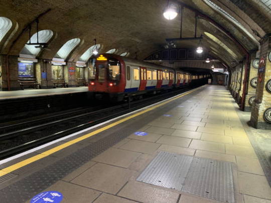
With its opening in 1863, the London Underground, also referred to as "the Tube," is the world's oldest underground railway system. The Tube, with its recognizable logo and iconic map, has grown to be a vital component of London's transportation network. With a service area of over 402 kilometers (250 miles) and 272 stations, it effectively links the city and offers convenient access to the main attractions. The London Tube is an essential feature of daily life for Londoners and a must-see for tourists alike. It not only displays Victorian engineering prowess but also illustrates the historical development of urban transportation.
3. Varieties of Languages throughout the Continent:
Europe boasts an impressive linguistic diversity, with more than 200 languages spoken in its numerous nations. 24 languages are recognized as official by the European Union, including well-known tongues like English, French, German, and Spanish. In addition, the cultural fabric of the continent is enhanced by innumerable minority languages and regional dialects, such as Basque and Catalan. This diversity of languages is a reflection of the intricate history of Europe, which has been shaped by many different empires, cultures, and communities. This diversity is frequently celebrated through festivals and educational initiatives, which makes language speakers feel proud of one another.
4. Creative Transportation Frameworks:
Europe is renowned for having extensive and effective public transportation networks, which make traveling throughout the continent easy and reasonably priced. Extensive rail networks with high-speed trains like the TGV and ICE connect major cities in a matter of hours in countries like France, Germany, and Spain. Furthermore, a lot of European cities place a high priority on environmentally friendly transit options like electric buses, trams, and bike lanes. This dedication to cutting-edge public transportation raises the bar for urban transportation globally while also improving travel experiences and promoting environmental sustainability.
5. Europe as a Special Political Organization:
A unique political and economic union, the European Union (EU) is made up of 27 member states that have made the decision to work closely together. The EU, which was founded to advance economic growth, peace, and stability, makes it easier for people to travel freely and to engage on a range of issues, such as security and environmental protection. This dedication to unification is further demonstrated by the Schengen Area, which permits travel between numerous EU nations without a passport. The EU is a fascinating case study in regional integration because of its unique political structure and policies that set it apart from other international organizations.
Conclusion:
Europe is a continent filled with unique facts that enhance its appeal as a travel destination. From the smallest independent state, Vatican City, to the vast linguistic diversity found in its 44 countries, Europe offers experiences that cater to every traveler's interest. Its innovative transportation systems, such as high-speed trains, make exploring multiple destinations seamless and enjoyable. The blend of rich history, modernity, and cultural diversity ensures that every visit to Europe is memorable and enlightening.
For those planning a Europe trip, these unique aspects add a layer of excitement and wonder to the journey. Whether it’s marveling at architectural masterpieces, indulging in diverse culinary delights, or immersing oneself in vibrant local traditions, Europe has something for everyone. As travelers uncover the continent's hidden gems and iconic landmarks, they are sure to leave with cherished memories and a deeper appreciation for the fascinating stories that shape Europe’s identity.
0 notes
Text
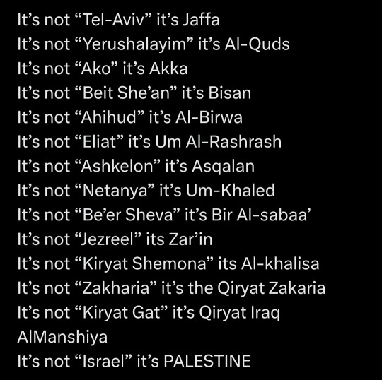
also, the oldest mention of Jeruselam is from like year 6/7 BCE and is likely a reference to a Canaanite god. The city was also common known as Eer Chadash (holy city in Hebrew) and Al Quds is basically a shortened translation of that name.
Also, this implies some things about Tel Aviv and Jaffa that aren't true. Tel Aviv started as a neighborhood where a bunch of Jews in Jaffa decided they want to live and it Grew bigger than Jaffa. While Tel Aviv now includes Jaffa but they're still separate and if you look on a map it'll say Tel Aviv-Yafo and if you look up Jaffa on google maps it'll take you to an area in the south of Tel Aviv-Yafo. Tel-Aviv did not just replace Jaffa like this post implies.
And Be'er Sheva was called that for thousands of years. like there's evidence that it's the same city as referenced in the Tanakh because it has been inhabited for like 5-6000 years which includes the Kingdom of Israel. The name Bir Al-Sabaa only came up in the Ottoman empire and is a direct translation of Be'er Sheva to arabic because both names mean well of the seven
Akka and Akko are literally the same name but Akko is hebrew and Akka is arabic
idk much about the other ones. I know you're trying to make a point about the settlements OP but this is why we fact check. This sort of stuff results in historical revisionism that erases the Jewish history of the Levant and contributes to those conspiracy theories that say Jews sprouted up out of Europe and made up a bunch of stuff about their past in the Levant which is not cool at all
6K notes
·
View notes
Text
Week 4
In todays session I wanted to start creating rough visuals so that we could confirm how we wanted to game to look. I took inspiration from other MMORPG style games, looking at the character creation sections and map designs. We definitely wanted there to be an element of character creation as we thought, even if there were some students that weren't enthusiastic about the gaming side of the project, the freedom of character design and creation could be an element that'd be exciting for all.


These were just a few of the images I used for reference when designing. Our maps weren't going to be as big as those shown above however, and we were instead using pixel art as Lace had said, from research, that this may be easier for them, but the basis of each would be similar. I started to roughly draft our map and the types of locations that we agreed would be appropriate to incorporate.


These were my initial sketches, I used procreate and started off very simple then started to add it extra details, such as the hill background to add some depth to the design as well as some shrubbery. I used sketches of the national Ukrainian sunflower and the English Tudor rose. These felt relevant but also helped to make the surrounding look nicer and add to the idyllic campus setting that we were aiming to create. I added some labels to the final design so that anyone that looked at them on the figma understood the reasoning and for the designs and how the map would function. Ideally clicking on the location and then being transported to the building and exploring what it holds. The playground we thought would contain a game that you'd play with another player. The library containing information on Ukrainian culture/Kyiv and Birmingham/British culture.
We began to discuss the kind of facts that we would include in the library and so added a post to the Figma asking the Ukrainian to send in any facts about Ukraine, and more specifically Kyiv. We also added posts that prompted creative responses. We decided that the characters would be two that you chose from and you can then customise their outfits, and so we prompted the students to respond with any imagery that may be useful in designing these outfits. The characters we decided on would either be a lion, the national animal of the Uk, and a nightingale bird, the national animal of Ukraine. The animal characters felt better as it was a nod to the inspiring countries, but also added to the fantasy elements of the game.
Below are some of the facts sent from one of the students
The Kiev metro is one of the oldest in Europe.
“Shchedryk” or “Carol of the Bells” the famous Ukrainian song that is known all over the world.
The longest pedestrian bridge in Europe is in Kiev, with a length of 429 metres.
One of the favourite dishes of Ukrainians is borscht, which is traditionally eaten with black bread, lard and chesnik (garlic)
Petrikovsky painting is a Ukrainian decorative and ornamental folk painting, which was formed in the Dnepropetrovsk region in the village of Petrikovka, from where the name of this art form comes.
I started to look into the costumes for the characters. The dressing/customization stations and the kinds of outfits that we wanted. This was an important element of the game for us as we had seen that from the results of the questionnaire so far, 100% of the students asked said that they'd 'be more inclined to play a game in which you can design/personalise your own character?'. We asked the Ukranian students about traditional clothing and uniforms that they wore as children. The majority response was that 'primary' colours were part of all our uniforms. The uniform visuals that the students sent through also showed quite a resemblance to the British uniforms. I again began to draft visuals of the 'dressing' element of the game, this was a useful way of ensuring that as a group we were all on the same page about the look of the game.

The image above shows how we communicated with the students in Kyiv via figma. Simply uploading optional tasks that they can chose to interact with. Though this worked and we received some useful visuals from them, we wanted a more immediate form of contact with direct students that we had conversed with via figma. This is when Niamh uploaded the poll to see how the students wanted to communicate. This happened to be via telegram, and so Niamh set up a telegram for us all to join and communicate more efficiently.


These were the kinds of visuals that I created for the avatar dressing station, I used photoshop to create these visuals as i though this would allow a cleaner look, as oppose to ketchup which I'd use for a more rough sketch. I included a small podium on which the character that the gamer selected would stand. And different variations of uniforms, created in the colours that we found were most common in primary uniforms in both the Uk and Kyiv. I tried to pixelate the image, I hadn't previously done this and so I used the adobe website and searched how to create this pixelated effect. I used the mosaic pixelation, and varied the scale of pixelation. Unfortunately the higher on the scale the lower the resolution of the image. I was glad that I had a go and discovered the method to pixelate an image. Even if it wasn't a completely coherent image.
0 notes
Text
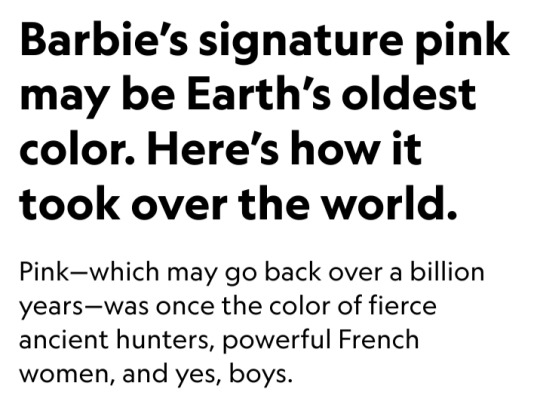

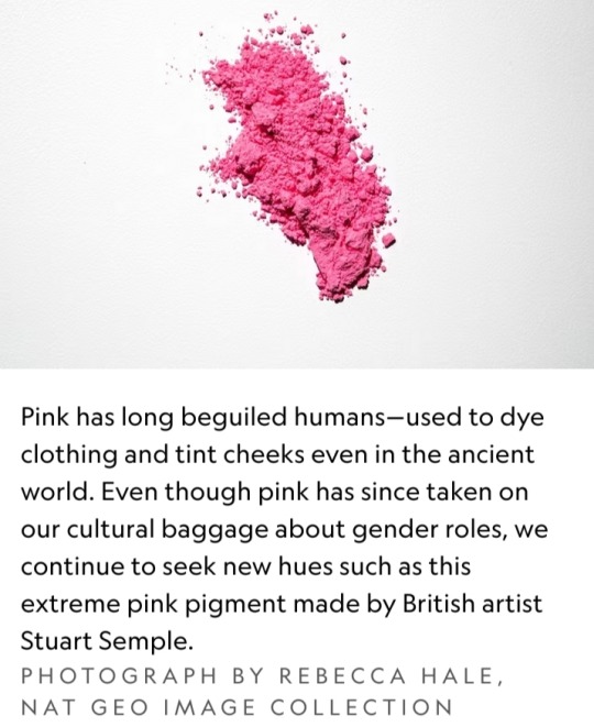
Could pink be Earth’s oldest color? That’s the implication of a 2018 study that found bright-pink pigments in 1.1 billion-year-old rocks — thanks to the fossils of the billions of tiny cyanobacteria that once dominated oceans.
The natural world has long been painted with every permutation of pink — whether embedded deep in ancient rock, sported by shrimp-hungry flamingoes, or simply lining the shores of Bermuda’s pink-sand beaches.
And yet the color carries a lot of cultural baggage.
As pink made the jump from nature’s palette to human adornment, it gathered connotations of colonialism, beauty, power, and gender.
How did pink become such a cultural flashpoint? As the world takes a revitalized interest in the hot-pink planet inhabited by Barbie, here’s a short history of the compelling color.
Admiration for pink in the ancient world
Early humans quickly transitioned from admiring pink in the natural world to attempting to wear it.
For example, in the Andes Mountains about 9,000 years ago, fierce hunters in what is now Peru wore tailored leather clothing with a pink hue thanks to red ochre, an iron oxide pigment that is one of the oldest natural pigments used by humans.
Humans weren’t content just to smear this pigment on cave walls or use it while tanning their leather garments.
As far back as ancient Egypt, humans used ochre to tint their lips and cheeks.
When applied to human skin, the red pigment created a blush-like pink that onlookers associated with love, sexuality, and beauty.
Lookalike concoctions prevailed around the world, employing everything from crushed strawberries to red amaranth.
The color of cosmetics—and colonialism
Though the word’s etymology is unknown, the word “pink” was used to describe the color in the 18th century.
By then, pink had become inextricably tied with colonialism — as demand for the pigment for cosmetics drove Europeans to harvest natural resources in other parts of the world.
For example, in a bid to make pinkish pigments from the bark and red sap of brazilwood trees, European traders forced enslaved workers to cut down so many of Brazil’s eponymous trees that the country was left deforested and the tree nearly driven extinct.

During this Era of Exploration, consumers also got their pink cheeks and lips from other pigments like carmine, derived from cochineal insects harvested in Central and South America under similar conditions.
Meanwhile, the color also had a more literal association with colonialism:
During this time, the British Empire grew so massive that the color pink — which mapmakers used to mark its territories worldwide — dominated the world map.
Pink becomes a bona fide fashion craze
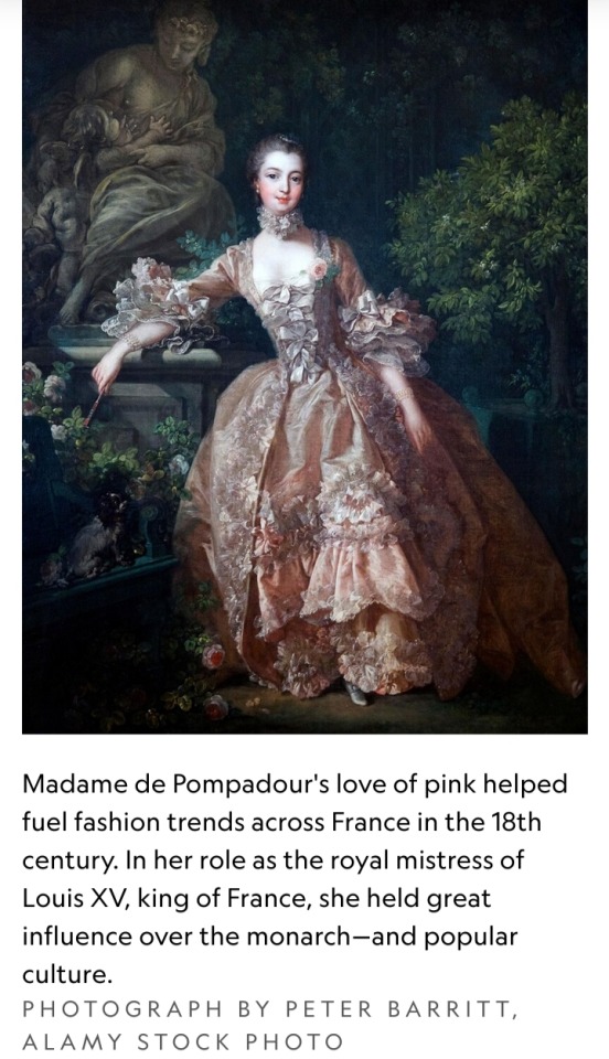
As red tints became more accessible and cheaper, 18th-century European aristocrats indulged a passion for pink.
Art historian Michel Pastoureau writes that “the most privileged classes of European society wanted pastels, halftones, and the newest innovations in color shades in order to distinguish themselves from the middle classes, who now had access to bright, strong, and reliable colors.”
Madame de Pompadour, the mistress of Louis XV of France during the 1740s and 1750s, used the color as a signature.
The artists who painted her and created fine objects for her many homes used pink in all their designs, even her carriages, and she helped further popularize the hue throughout Europe.
The emergence of synthetic dyes in the mid-19th century — which gave rise to the purple-pink color known as mauve — made pink more accessible than ever before.
By the 1930s, bright pink had become a bona fide fashion craze.
Avant-garde fashion designer Elsa Schiaparelli made “shocking pink” her signature color, helping spread the vogue for women’s wear.
It worked: By 1935, even local newspapers like the News and Observer in Raleigh, North Carolina, were declaring that “PINK IS FAVORITE.”
And in 1939, a royal commentator wrote in London’s Daily Telegraph that pink was so popular, it was nearly ubiquitous for both bridesmaids and debutantes.
“So general is the pink craze,” the paper wrote, “that some women are rebelling against it.”
Pink is for…boys?
Around the same time, pink gained relevance in another realm: baby fashion.
Gender and baby fashion had intersected for years; around World War I, etiquette guides and fashion advice columns began advising that mothers dress their children in clothing with gender-specific hues.
But which colors? A 1927 retailer survey on infant clothing colors published in TIME shows a split nation, with retailers like Filene’s and Marshall Field’s recommending pink for boys, but Macy’s, Bullock’s, and others claiming pink was best for girls.
By the 1960s, however, mothers began buying pink clothing for their female babies, dressing their male children in pastel blues.
“None of this transition happened by childcare expert fiat or industry proclamation,” writes historian Jo B. Paoletti.
Instead, pink gained steam as a signifier of a baby’s female sex as part of a post-World War II push to reinforce traditional gender roles in American homes — and the realization by retailers that they could make more money that way.
“The more baby clothing could be designed for an individual child — and sex was the easiest and most obvious way to distinguish babies — the harder it would be for parents to hand down clothing from one child to the next, and the more clothing they would have to buy as their family grew,” Paoletti writes.
Soon, retailers featured entire “pink aisles” packed with pink-colored clothing and toys for tiny consumers.
The dark side of pink
Pink was also rejected by some as a symbol of weakness or even sinister intent.
In Nazi Germany, for example, the color was used to brand gay men in concentration and death camps.
As the Cold War emerged, suspected Communist sympathizers were given the derogatory name of “pinkos” — a term that referred to a person with “red” tendencies toward radical politics.
Meanwhile, members of the women’s liberation movement attempted to distance themselves from a color that had become inextricably linked with femininity and sexuality — think: Marilyn Monroe slinking down a staircase in a shocking pink gown, surrounded by tuxedoed men.
Anti-feminists, meanwhile, embraced pink.
Author Helen B. Andelin, for example, made public appearances in all-pink ensembles in the 1960s and 1970s during lectures encouraging women to abandon feminism and embrace lives as housewives.
Reclaiming pink
Pink remains associated with femininity to this day — but in recent decades, groups once disdainfully branded with the color have made moves to reclaim it.
In the LGBTQ community, for example, people who were once forced to wear pink as outcasts have adopted the hue as a symbol of their movement for social justice.
In 1987, the AIDS Coalition to Unleash Power (ACT UP) adopted a bubble-gum pink triangle in its “Silence = Death” campaign to increase awareness of HIV-AIDS and destigmatize the disease.
It was just one example of pink being used to represent gay pride.
Some feminists have also reclaimed the color, fighting gender stereotypes with a tongue-in-cheek adoption of all shades of rose, fuchsia, and bubble-gum pink.
At the 2017 Women’s March, for example, a sea of protesters wearing pink, cat-eared “pussy hats” protested the inauguration of U.S. President Donald Trump, whose lewd remarks about female genitalia during a leaked interview drew worldwide condemnation.
Today, pink is what you make of it — and it has grown in popularity once more.
In 2016, Pantone announced that a shade of dusty pink — dubbed Millennial Pink for the generation that had embraced it—was its Color of the Year.
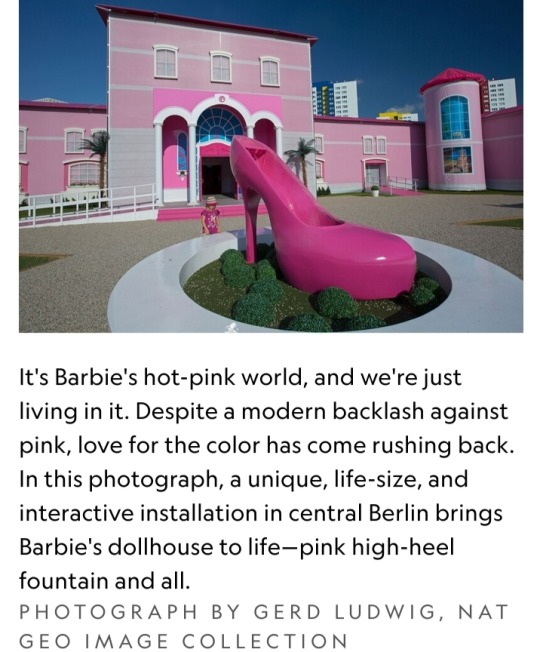
This year, Greta Gerwig’s upcoming Barbie movie helped fuel the rise of the pink-drenched “Barbiecore” aesthetic, inspiring admirers to saturate their homes and wardrobes with every shade of pink.
According to Axios, searches for the term “Barbiecore aesthetic room” rose over 1,000 percent between May 2022 and May 2023, reflecting consumers’ craving for as-pink-as-possible interiors.
There’s no telling which permutation of pink will captivate us next — but given the colorful history of the hues that fall somewhere between white and red, pink’s next heyday is probably right around the corner.

Barbie would approve of the pink petals on this beach morning glory.
Pink flowers like this one get their rosy tinge from a group of biological pigments called anthocyanins, which attract pollinators — and human admirers — to colors ranging from the palest carnation to the most ostentatious tropical fuchsia.
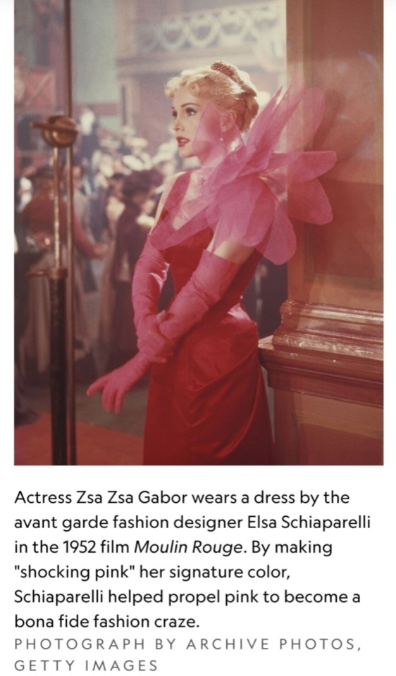
#pink#red ochre#carmine#Era of Exploration#Madame de Pompadour#Louis XV of France#mauve#Elsa Schiaparelli#gender#baby fashion#colors#Helen B. Andelin#AIDS Coalition to Unleash Power (ACT UP)#Pantone#Millennial Pink#Barbie#Nat Geo#fashion#political movement#Marilyn Monroe#Zsa Zsa Gabor#pigment
14 notes
·
View notes
Text
From Ancient Beginnings to Modern Glory: Untangling the Rich History of Football
Introduction
Soccer, additionally referred to as football in lots of components of the globe, is a sporting activity that has actually captured the hearts and minds of billions of individuals. It is a game full of enthusiasm, skill, and excitement. However have you ever before questioned exactly how this gorgeous video game originated? In this post, we will certainly dive deep into the background of football and explore its old beginnings, mapping its advancement via time to its contemporary glory.
From Ancient Origins to Modern Magnificence: Unwinding the Rich Background of Soccer The Very Early Starts: Old Beginnings of Soccer
The origins of football can be traced back hundreds of years to old people. Evidence recommends that ballgame resembling soccer were played by various societies across the globe. In Ancient China, a game called "Cuju" was played throughout the Han Empire (206 BC-- 220 AD). Cuju entailed kicking a leather ball into a tiny internet without using hands.
Similarly, in Old Greece and Rome, variants of soccer-like games were prominent. The Greeks had actually a game called "Episkyros," which involved two teams trying to toss or kick a ball over their opponent's border lines. The Romans Soccer Way had a similar game called "Harpastum," which was played on a rectangle-shaped field.
Medieval Times: The Development of Soccer
As time took place, soccer-like games remained to develop in numerous kinds throughout medieval Europe. These games were often played in towns and towns as component of conventional celebrations and festivities.
youtube
In England, a very early form of football arised during the Center Ages. Referred to as "mob football," it was a disorderly and rough game played in between rival villages or communities. There were no policies or limits, and numerous players would certainly participate. The purpose was simple-- get the ball to your opponent's town or town.
youtube


Modern Guidelines: Systematizing the Game
As football gained appeal across various areas, there was a requirement to standardize the rules of the game. In 1863, the Football Organization (FA) was established in England, and they established the very first collection of official rules for soccer. These rules included specifying the dimensions of the area, determining the variety of players per team, and specifying fouls and penalties.
The growth of standard rules led the way for arranged competitors and organizations. The initial authorities football organization, known as the English Football Organization (EFL), was created in 1888. It included twelve clubs and rapidly ended up being a significant success.

Global Growth: Football Spreads Throughout Continents
From its simple starts in ancient times to its modern-day type, football has spread out across continents and recorded the hearts of people worldwide. In the late 19th century, British sailors and vendors introduced soccer to various components of the globe, consisting of South America and Africa.
South America welcomed soccer with tremendous interest, resulting in the development of different nationwide groups and expert leagues. The Copa America, established in 1916, became one of the oldest global soccer tournaments.
Similarly, in Africa, soccer came to be an integral part of society throughout early american times. The sporting activity gave a system for social combination and resistance aga
1 note
·
View note
Text
Oakhurst Rock Shelter

Source: https://en.wikipedia.org/wiki/Wilton_culture#/maplink/0
On the southern coast of South Africa, about halfway between Cape Town and Gqeberha, near the town of George, is one location used by the Wilton culture known as the Oakhurst Rock Shelter. The Wilton culture is known as a technocomplex, or an Archaeological culture as opposed to what we would know as a culture with a shared set of values and behaviors. They shared stone and non-stone type tools, which included microlithic tools such as scrapers, and a general ending around the time pottery was introduced to the area.

Source: https://www.livescience.com/archaeology/ancient-dna-from-south-africa-rock-shelter-reveals-the-same-human-population-stayed-there-for-9000-years
Oakhurst was first rediscovered in the 1930s, which was then determined to have housed humans for 12,000 years. Rock art, stone tool, ceramic fragments, and the remains of 46 people have been fund in the location. Burials in South Africa are very rare finds, even more so for individuals. With new technology, it's now possible to map the genomes 13 of those people.

Source: https://whc.unesco.org/en/list/1545/
The oldest genomes they were able to sequence were from two people who lived about 10,000 years ago. What these results showed was that, unlike areas like Mesopotamia and the Levant, there weren't waves of people coming to replace those who were there leading to mixing, the population was stable at least through 1,300 years ago. The genomes were found to be remarkably similar, especially since Africa has the highest genetic diversity in the world. The genomes are related to the modern ǂKhomani San people with no relation to people groups outside of Africa. It is known that another people group arrived around 2,000 years ago, but even the newest genome, from 1,300 years ago, were genetically similar to the older genomes and didn't show any mixing with the new group.
While archaeologists have been able to trace movements through Asia and Europe via genetics, most of Africa has temperatures that are too high on average to preserve genetic information, making the genetic information these skeletons provided even more precious. Even with the samples, some required several attempts to recover, eventually some requiring bone to be powdered to extract DNA.
7 notes
·
View notes
Text
Historic Centre of Vilnius

Embark with me on a virtual journey to the UNESCO World Heritage site—the Historic Centre of Vilnius in Lithuania. Join the adventure as we traverse winding streets, unravel layers of history, and bask in the vibrant charm of this Baltic jewel.
In 1994, the Historic Centre of Vilnius earned UNESCO World Heritage status. This recognition celebrates Vilnius as a living testament to the coexistence of various architectural styles, cultures, and religions—a harmonious blend that defines its unique character.
Step into Cathedral Square, the pulsating heart of Vilnius. Admire the grandeur of Vilnius Cathedral and the iconic Bell Tower. This square is where history unfolds, from coronations to celebrations, and serves as a gathering place for locals and visitors alike.
Behold the exquisite beauty of St. Anne's Church, a Gothic masterpiece that enchants with its intricate brickwork. Wander through its sacral ambiance and imagine the echoes of hymns and prayers that have graced its hallowed halls through the ages.
Explore the University of Vilnius, one of the oldest universities in Central Europe. Admire the classic architecture of the Grand Courtyard and Library, where the pursuit of knowledge has flourished for centuries.
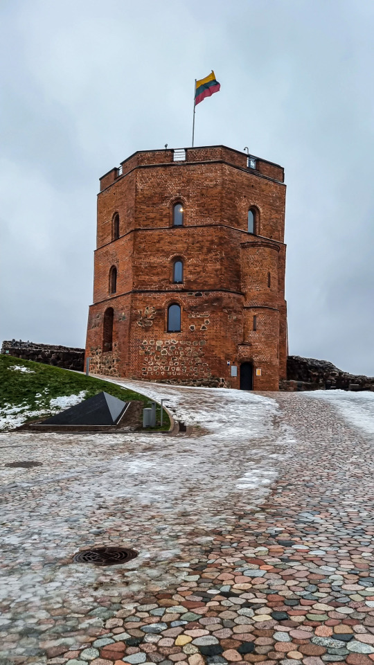
Ascend the Gediminas Castle Hill, where the eponymous tower stands tall as a sentinel overlooking Vilnius. Marvel at panoramic views of the cityscape and the confluence of the Neris and Vilnia rivers—a sight that has witnessed centuries of Vilnius' evolution.
Visit the Gate of Dawn, a revered pilgrimage site housing the miraculous painting of the Virgin Mary. Feel the spiritual energy as you pass through this historical gate, which has witnessed countless prayers and pilgrimages.
Cross the river to Užupis, a bohemian district known as the "Republic of Užupis." Marvel at its artistic spirit, adorned with street art, quirky sculptures, and the Constitution of Užupis, emphasizing the pursuit of happiness, love, and the right to be oneself.
Embark on a virtual expedition of Vilnius through online galleries, interactive maps, and immersive experiences. Roam the streets virtually, discover hidden gems, and soak in the cultural richness of this UNESCO-listed gem—all from the comfort of your digital realm.
In conclusion, Vilnius invites you to dance through its cobblestone streets, where history and creativity intertwine. When you're ready for a digital odyssey through a UNESCO World Heritage site that captures the essence of Lithuanian heritage, Vilnius beckons with open arms. 🏰🌈✨🇱🇹
#vilnius#historic#center#city#town#lithuania#europe#travel#unesco#world heritage#culture#cultural#exploration#baltic
0 notes
Text
The embroidered textiles are called suzanis. They are found in Central Asian and particularly associated with Uzbekistan, which is where Bukhara is located. Suzanis are gorgeous, and Uzbekistan overall is known for its incredible textile production and arts! Ikat print—via fabric dying and weaving and painting—is another staple of Uzbekistan’s design style.
Bukhara has Persian roots and was a prominent center of trade, scholarship, and culture along the historic Silk Road. Even today, Tajik (a language related to Persian) remains a dominant local language, rather than Uzbek (a Turkic language).
Bukharan Jews were part of a larger group of Persian-speaking Jewish communities that also lived in modern day Iran and Afghanistan, as well as other parts of Central Asia. This was distinct from other Soviet Jewish groups in Eastern Europe, who primarily spoke Yiddish in the late 1800s and shifted to Russian in the 1900s.
Bukharan Jews are one of the oldest ethnic-religious groups in Central Asia, and their roots go back hundreds of years. Sadly, they also faced many periods of persecution.
In the 20th Century, the Soviet Union’s policies stressed assimilation and the removal of religious practice. Soviet propaganda painted all the ethnicities within the USSR as living in harmony and being equal, but this was never really the case. Central Asians—who are predominantly non-white, secular Muslims—continue to face discrimination and stereotyping even today. Antisemitism was also ever present during Soviet times, especially during the 1950s-80s.
Despite their rich history and deep roots, Bukharan Jews became more and more isolated. Many emigrated out of Central Asia to find more welcoming spaces. (Overall, Jewish out migration accelerated approaching and after the USSR collapsed in 1991.) A particularly notable community of Bukharan Jews settled in Queens in New York City. If you’re in the area, you should try to find some Uzbek food—like the textiles and art, the food is also incredible.
This was a super brief take! Here are some resources to read more:

In the former house of a wealthy Jewish merchant, Bukhara, Uzbekistan, 19th century.
#bukharan jews#uzbekistan#jewish#folk art#art#jumblr#ikat#suzani#bukharian Jews#bukhara#history stuff#Jewish emigration#rego park#queens nyc#Бухарские евреи#ussr#Central Asia
243 notes
·
View notes