#mobile mapping
Explore tagged Tumblr posts
Visit Tumblr Blog
Explore Tumblr blogs with no restrictions, modern design and the best experience.
Last Seen Tumblr Blogs


Fun Fact
China blocked Tumblr because of pornography and censorship problems in 2013.
Text
Mobile Mapping Explained

Mobile mapping is a technique used to survey infrastructure through the use of vehicles rather than boots-on-the-ground efforts.
These vehicles, including automobiles, drones, and boats, are equipped with various sensors, including LiDAR technology, cameras, and GPS receivers. The sensors rapidly collect detailed 3D data of the environment as the vehicle moves.
The result is an accurate 3D model of the surroundings, which can be used for a wide variety of applications in transportation, urban planning, and infrastructure management.
It’s not only more accurate than on-the-ground surveys but it is safer and less disruptive.
How Mobile Mapping Works
The core technology behind mobile mapping is LiDAR (Light Detection and Ranging), which uses laser pulses to measure distances between the sensor and surrounding objects.
The data collected creates a "point cloud," representing the scanned environment in 3D.
Alongside LiDAR, high-resolution cameras capture imagery, which can be integrated with the LiDAR data to enhance its visualization.
The vehicle also uses GPS and sensors called inertial measurement units to ensure data accuracy even while moving or encountering bumps in the road.
The mobile mapping process typically follows these steps:
Data Collection: A vehicle equipped with LiDAR sensors, cameras, and GPS systems captures detailed data on roads, buildings, and other infrastructure as it moves along the planned route.
Data Processing: Specialized software processes the raw data, aligning and filtering it to create accurate and usable geospatial information. Algorithms integrate the different datasets, ensuring accuracy and consistency.
Analysis and Visualization: The data is analyzed using tools that can extract meaningful insights, such as identifying structural issues in roads or bridges. It is then visualized through interactive 3D models or maps for easier interpretation and decision-making.
Applications in Transportation Projects
Mobile mapping is highly suited for various transportation infrastructure projects due to its accuracy and efficiency:
Roadway and Rail Network Mapping: This technique maps road surfaces, rail lines, and surrounding infrastructure, such as bridges and signage. The data generated supports road design, maintenance, and expansion projects.
Bridge and Tunnel Inspection: Mobile mapping is ideal for detecting structural issues, such as cracks and deformations, without disrupting traffic, because it can capture data under bridges and tunnels.
Right-of-Way (ROW) Surveys: Detailed mapping of road corridors allows transportation agencies to manage their right-of-way assets efficiently, making it easier to plan for expansions or repairs.
Accuracy of Mobile Mapping
Mobile mapping achieves impressive accuracy down to just centimeters.
The accuracy depends on the quality of the sensors used, the speed of the data acquisition, and the environmental conditions.
Compared to airborne LiDAR, mobile mapping typically provides higher-resolution data since the sensors are closer to the ground.
Mobile Mapping vs. Traditional Surveying Methods
Mobile mapping offers several advantages over traditional surveying:
Speed: It collects data much faster than manual methods, which require surveyors to walk the project area, often over multiple days. With mobile mapping, large areas can be scanned in a fraction of the time, sometimes within hours.
Safety: By eliminating the need for surveyors to physically access dangerous or high-traffic areas, mobile mapping enhances safety for workers.
Data Detail: Mobile mapping captures significantly more data than manual surveys, providing a complete 3D model of the environment, rather than just individual points of interest
Mobile mapping first started gaining popularity in the 1980s, and it is still growing — now projected to be a sector of the market worth $105 billion by 2029.
Using Mobile Mapping Data
Once collected, the data from mobile mapping can be used in numerous ways:
3D Modeling: Engineers use the detailed 3D models for designing transportation infrastructure, including roads, railways, and bridges.
Asset Management: Transportation departments use the data to manage and monitor infrastructure assets, from traffic signs to utilities.
Maintenance Planning: The collected data supports proactive maintenance by identifying issues such as pavement cracks, surface deformations, or vegetation encroachments, enabling timely repairs.
In conclusion, mobile mapping is a highly effective and efficient tool for collecting geospatial data, particularly for transportation projects.
Its ability to capture detailed, high-accuracy data quickly and safely makes it a superior choice over traditional surveying methods, especially in complex environments like roadways and rail networks.
As technology continues to evolve, mobile mapping will become increasingly important in infrastructure development and maintenance.
1 note
·
View note
Text

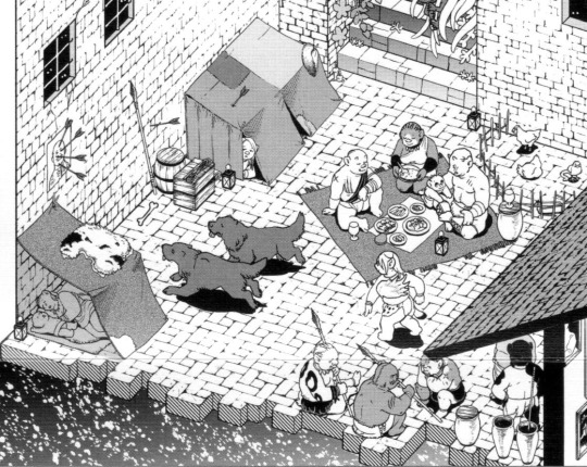
Dungeon Meshi Adventurer's Bible - Dungeon cross section
Details under the cut
Details cropped from this reddit post

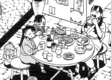
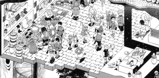
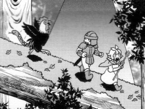
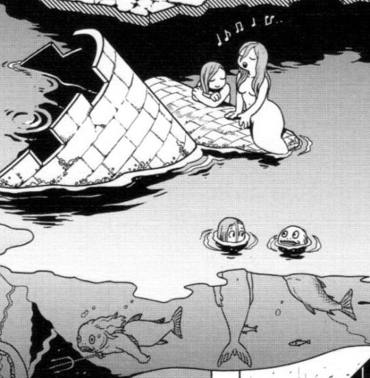
#Dungeon Meshi#adventurers bible#took me a LONG time to find a good quality full version of this#please open the full image to properly see it#tumblr mobile also ruins the quality..#Falin touden#marcille donato#chilchuck tims#leed#leed dungeon meshi#orcs#mermaid#fionil#doni#inutade#tade#hien#benichidori#is hien winking at the waitress?#worldbuilding#dungeon layout#dungeon levels#red dragon#dungeon meshi orcs#maps#for referencing
5K notes
·
View notes
Text
sam winchester WISHES he had my copiloting passenger skills
#finding the best gas price and place to get dinner then placing the mobile order to get us a coupon#then directing my dad to get back on the interstate while passing out food and getting the map and music pulled back up#the real supernatural we were robbed of.
49 notes
·
View notes
Text

⏤ Welcome to mcytblrsource! A source blog dedicated on keeping track of current and past events, zines/art books, and more! regarding mcytblr and mcyt.
tracking: #mcytblrsource tag us in events, zines, and more! you can also tag us in commission posts!

MONTHLY RECAP
members:
mod tides: @blocky-tides
mod a10: @boxbug / @blocksnbeetles
#QUICK TAGS FOR MOBILE:#events#blogs#zines#resources#commissions#merch#MAP#monthly recap#gift exchange
240 notes
·
View notes
Note
So, who are y'all exactly?
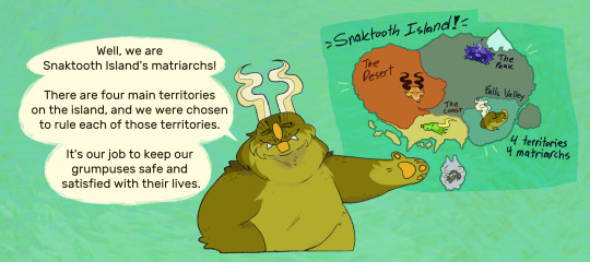


The main gals (and Ehsel)! A bit more information about them and a few other grumpuses that'll show up can be found on the blog's Characters page!
#if the link doesn't work on mobile. try copying it and pasting it into whatever browser app you have! that'll most likely help#Olsa is famous for never being obvious about her clear biases and never leaves out important information about anything :]#character asks#matriarchs#Stone Era#Olsa Patchfern#Elass Dunecuts#Monohorn#Ehsel Shimmerface#Captain Seaside#Imony Crashtooth#Tuhonee Crashtooth#bugsnax#edit: Bit of a correction. There are four territories that grumpus communities Live in. But there are actually six territories on Snaktooth#There's the Gathering Place and The Woods. not labeled here on the map
141 notes
·
View notes
Text
[ENG] Love and Deepspace PC tutorial
When I wrote the original tutorial, I didn't notice the emulator was available in English too! It can be downloaded on their official website.

https://www.mumuplayer.com/en/games/simulation/love-and-deepspace-on-pc.html
Mumu is an officially licensed emulator for Love and Deepspace. What the emulator does essentially is to host the game on a computer. Other games can also run on this emulator, such as MLQC, Nikki series, Arknights, Genshin etc...
Availability: Windows, Mac
Recommended configuration: CPU 4-core + RAM 4G+ System i5+ Graphics Card GTX750Ti+
Game size: 20-30 GB
The instructions on the website appears to be quite clear, I am assuming it's more or less the same as the Chinese one. I suggest looking up if your computer supports VT first before downloading the emulator.
It should be fairly straight forward once VT is enabled in BIOS. If the instructions on the mumu website is unclear, find a tutorial on google/youtube for your PC type, try looking up "how to enable virtualization in bios".
Any questions feel free to drop me an ask with images ദ്ദി(˵ •̀ ᴗ •́ ˵ ) ✧
───── ⑅ ♡ ⑅ ─────
More like this:
Original Deepspace PC guide + tips // Deepspace live wallpaper guide
#love and deepspace#恋与深空#love and deep space#mlqc#love nikki#ive seen some tags left on posts saying they wish this was on pc so i thought i'll share this!!#its life changing once you get to play it on a big screen you can never go back to mobile esp if you have a vertical monitor#can also map controllers to play as well 👌👌#the game size is a rough reference i have all the game specs on max so it probably takes a bit more storage up
36 notes
·
View notes
Text
I go rabid for fanart/ fics that give Remus mobility aids. Grahhhh yes give him crutches!!!!! He would be so against using them but I don’t care!!! Sirius would make him, especially on particularly hard days.
#like there’s no way that a man who was breaking his bones once a month was not using mobility aids???#like not once??#be realistic.#ignore the fact I said that about a piece of media where magic is canon#marauders#harry potter#marauders era#sirius black#remus lupin#atyd marauders#the maraunders map#atyd#wolfstar
42 notes
·
View notes
Text
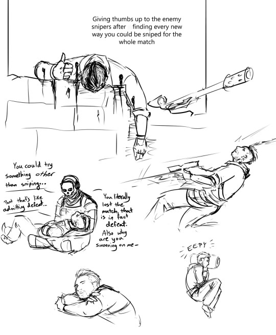
More very sketchy, very unreferenced Call of Duty, featuring: the drama of me playing sniper, and Soap whining about it.
I am always impressed by the snipers that manage to get me before I even find them, or change up tactics to get the advantage if I'm wiping them out.
(..... And I am frequently wiping them out)
#call of duty#cod soap#John “Soap” Mactavish#CoDM#call of duty mobile#cod ghost#Simon “Ghost” Riley#modern warfare#crossfire is my chill map for obliterating people#so eepy
73 notes
·
View notes
Text


Escape to Witch Mountain John Hough. 1975
UFO Penon Peak Trail, Santa Lucia Preserve, Carmel-By-The-Sea, CA 93923, USA See in map
See in imdb
#john hough#escape to witch mountain#helicopter#RV#donald pleasence#carmel by the sea#mobile home#eddie albert#ike eisenmann#kim richards#denver pyle#alien#santa lucia preserve#UFO#peñon peak#california#united states#movie#cinema#film#location#google maps#street view#1975
38 notes
·
View notes
Text
What-If: American Railroads — Maps
I deeply apologize for not coming back to this alternate railroad history topic in over a year, I’ve had a lot of other things to do and i merely scratched the surface of this railroad history topic. and therefore, I’ve thought long and hard about this whole thing.
Aside from that apology, i thought to myself since I have Procreate, why not make maps of the 20 American railroads in my alternate history about said American railroads? And that’s what I did. Each map below shows the 20 railroads after they absorbed the smaller railroads as well as some of them expanding their networks in the 1980s wherever possible.

New York Central — this map shows the New York Central after the road to the future absorbed Boston & Maine, New Haven , Delaware & Hudson, Rutland Railroad, Bangor & Aroostook, Central Vermont And Maine Central railroads.
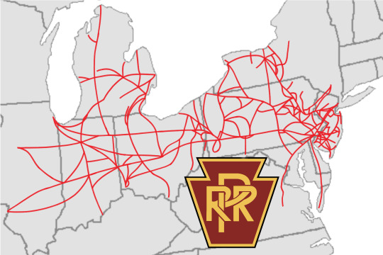
2. Pennsylvania Railroad — This map shows the size of the Pennsylvania Railroad after it absorbed Lehigh New England, Reading Lines/Railroad, Richmond, Fredericksburg and Potomac, Lehigh Valley, Lehigh and Hudson River, Central Railroad of New Jersey, Grand Trunk Western and Pennsylvania-Reading Seashore Lines railroads.

3. Chesapeake & Ohio — This map shows the Chesapeake & Ohio after it acquired the Erie Railroad, Lackawanna Railroad and New York, Ontario & Western Railway, plus the northern section of the Louisville & Nashville Railroad throughout the 50s and 60s, as well as expanding its network in the 80s.
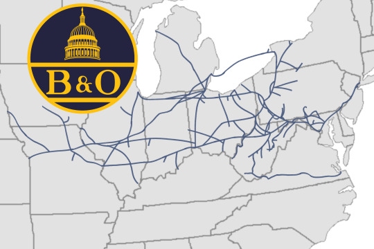
4. Baltimore & Ohio — This map shows how big the Baltimore & Ohio got after America’s first railroad absorbed Pittsburgh and Lake Erie, Western Maryland, Wabash, Ann Arbor, Virginian railroads.
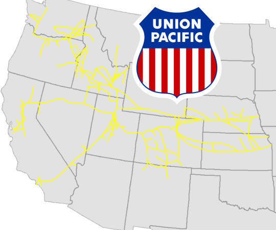
5. Union Pacific — Here, this is how big Union Pacific got after absorbing the Western Pacific and Rio Grande railroads, as well as adding more mainlines in the eighties.
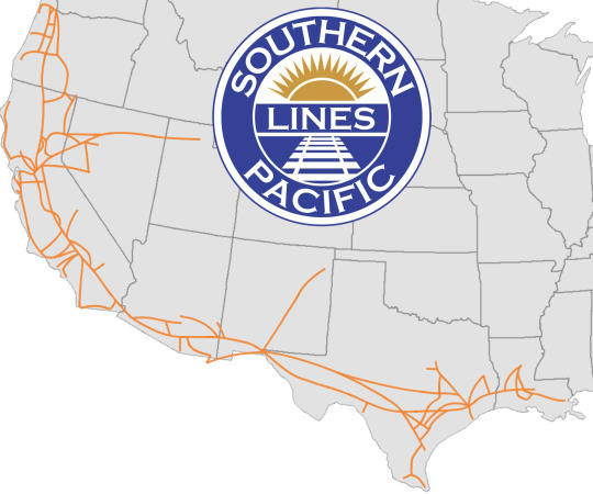
6. Southern Pacific — This map shows the Southern Pacific after adding more mainlines to its network in the eighties.
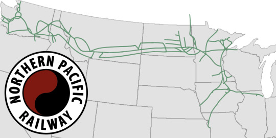
7. Northern Pacific — For this map, it shows how big the Northern Pacific Railway got after absorbing the Chicago Great Western and Duluth, Missabe and Iron Range railroads, as well as adding more mainlines to its network in the eighties.

8. Milwaukee Road — This map shows how big the Milwaukee Road got after the “Route of the Hiawatha” expanded its network by widening its existing mainlines and adding more mainlines (wherever possible) and expanding to northeastern Minnesota throughout the eighties.

9. Burlington Route — This map shows the Burlington Route after it absorbed the Kansas City Southern in the early 1960s and later expanded its network in the eighties.
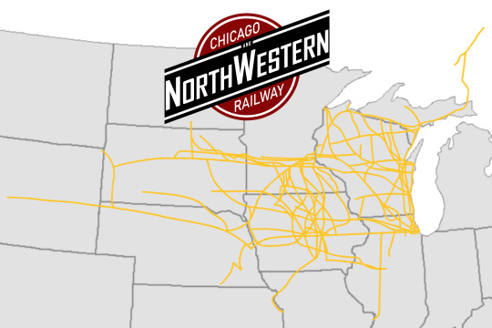
10. Chicago & NorthWestern — This map shows the size of Union Pacific’s ancient partner; the Chicago & NorthWestern, after it absorbed the Wisconsin Central and the Minneapolis and St. Louis railroads in the 60s plus expanding its network in the 80s.
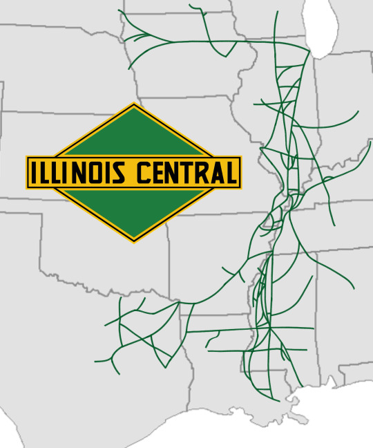
11. Illinois Central — This network map shows how big the Illinois Central got after acquiring the Cotton Bell Route in the 60s plus expanding its network in the 80s.
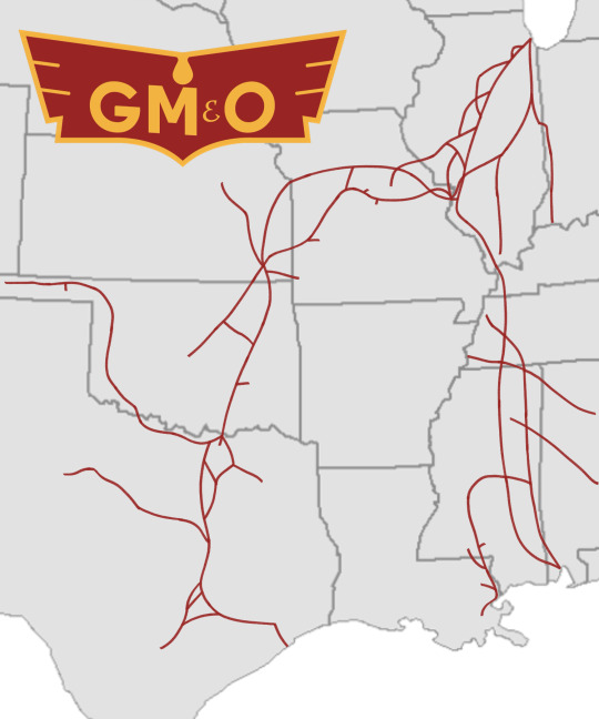
12. Gulf Mobile & Ohio — This map shows the size of the arch rival of the Illinois Central; the Gulf Mobile & Ohio, after it acquired the Chicago & Eastern Illinois and Missorui-Kansas-Texas railroads
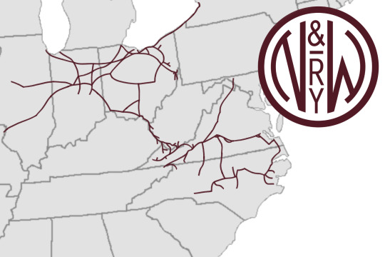
13. Norfolk & Western — Here, the map of the Norfolk & Western shows how big the N&W got after absorbing Nickel Plate Road and the (original) Norfolk Southern in throughout the 50s and 60s.
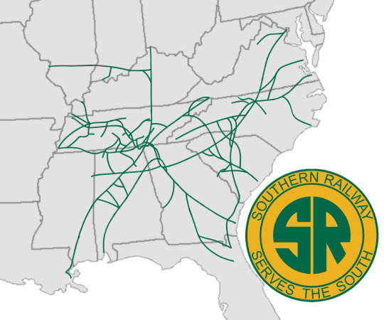
14. Southern Railway — This map of the Southern Railway shows how big the Southern got after absorbing Nashville, Chattanooga & St. Louis railroad and the central section of the Louisville & Nashville railroad in the 50s and 60s, as well as expanding its network in the 80s.

15. Seaboard Air Line — here, the Seaboard Air Line is shown how big it got after acquiring the Central of Georgia and West Point Route railroads plus the southern section of the Louisville & Nashville Railroad.
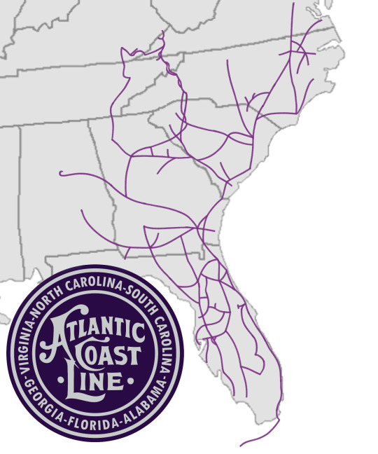
16. Atlantic Coast Line — This map shows how big Atlantic Coast Line after it absorbed Clinchfield Railroad, Oneida and Western and Florida East Coast railroads throughout the late 50s to late 60s.
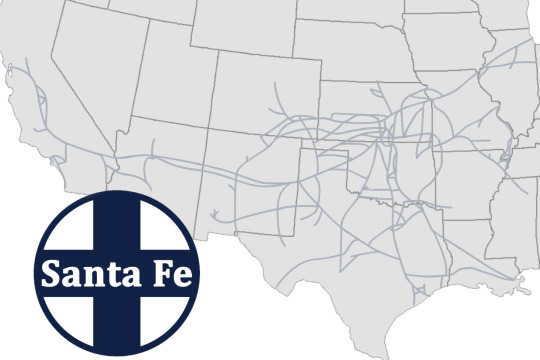
17. Santa Fe — This map shows the Santa Fe Railway after it absorbed half of the Frisco railroad in the early sixties and later expanded its network in the eighties.
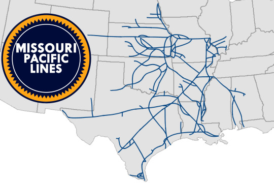
18. Missouri Pacific — This map shows the size of the Missouri Pacific after it absorbed the other half of the Frisco railroad and the Texas & Pacific Railroad in the early to late sixties.
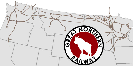
19. Great Northern — This map shows the size that Great northern Railway underwent after absorbing the Spokane Portland and Seattle Railway and adding more mainlines.
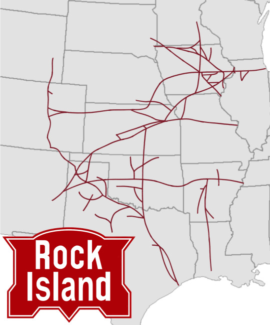
20. Rock Island — This map right here shows how big the Chicago Rock island and Pacific Railroad, or the Rock Island Railroad for short, has gotten after absorbing the Colorado and Southern Railroad and adding more mainlines and connecting to other mainlines order Rock Island ownership.
And with that, these maps show how big the railroads above have gotten. And since I’ve just returned to this topic, I’ll dig deeper into my thoughts and ideas about how things would go in this alternate timeline, which includes more posts talking about the history and posts talking about the locomotives and liveries on said locomotives, so stay tuned for all that.
#history#alternate history#alternate universe#railroad map#alternate timeline#new york central#pennsylvania railroad#chesapeake & ohio#baltimore & ohio#union pacific#southern pacific#northern pacific#milwaukee road#burlington route#chicago & north western#illinois central#gulf mobile & ohio#norfolk and western#southern railway#seaboard air line#atlantic coast line#santa fe railroad#missouri pacific#great northern#rock island#map#maps
8 notes
·
View notes
Text

Cover panels of a vintage Mobilgas road map of California, Nevada and Arizona.
#vintage advertising#vintage maps#vintatge road maps#road maps#gas staions#service stations#maps#mobilgas#mobil oil#mobil#mobil gas#standard oil#oil & gas companies#energy companies#fossil fuels#mobiloil#gasoline#travel maps
9 notes
·
View notes
Text
Civilization 1: a deep strategy game with a map spanning the entire Earth, almost unheard of at the time
Civ 2: huge maps with as many cities as the engine limitations could handle, fan-made scenarios could make both realistic depictions of the entire Earth and specific battlefields down to the hamlet
Civ 3: maps are less large but you can still simulate world-wide realistic scenarios with dozens of nations
Civ 4: maps get smaller, scripts and mods allow you to simulate historical scenarios but the scope gets even smaller, ironically allowing you to play with less
Civ 5: maps get even smaller, focused on hex combat regardless of scale, the Earth maps makes for strange things like archers shooting across the English Channel, graphics increasingly cartoonish
Civ 6: now cities have districts that make them spread across whole continents, maps get so small that even Civ 1 seems large, arcade gameplay, graphics are caricatures at this point
Civ 7: presumably it will be cartoons of unique units of samurai and legionaries fighting in 10x10 hex maps
Civ 8: two houses shooting at each other
#civilization#cosas mias#and this Mankind game is going the same way with cities covering entire continents#same with Millenia#fuck you tiny strategy maps with fucking districts I'm not playing a mobile game I want to play history
75 notes
·
View notes
Photo
🌍✨ Hey there, wallpaper enthusiasts! Are you ready to take a little trip down memory lane? We’ve just released a stunning Vintage Map Wallpaper that’s bound to add a splash of nostalgia to your desktop or mobile device! 🗺️💖
This beautifully crafted wallpaper features intricate details and a charming old-world aesthetic that will transport you to a time when maps were hand-drawn and adventure awaited around every corner. Whether you're a history buff, a travel lover, or just someone who appreciates the beauty of vintage art, this wallpaper is perfect for you!
Imagine looking at your screen and feeling inspired to explore the world, all while enjoying the classic vibes this wallpaper brings. It’s not just a background, it’s a conversation starter! Plus, it’s versatile enough to fit any style, whether you’re into modern minimalism or cozy retro decor.
If you're ready to transform your screen, you can grab this beauty right here: Explore the Vintage Map Wallpaper. Trust us, your device will thank you! 😉
Stay tuned for more unique wallpapers coming your way. Happy decorating! 🎉
Cheers! The Wallpapers Monster Team
#vintage#retro#map#wallpaper#desktop#mobile#nostalgia#travel#adventure#art#design#background#classic#intricate#exploration#history#hand-drawn#decor#style#aesthetic
5 notes
·
View notes
Text
CONGRATS WATER FLIGHT THE SPECIAL PRIZE WAS DAD ACKNOWLEDGING YOU
Oh and Wind Ig
#flight rising#fr#unfathomable odyssey#okay but this is actually so interesting to me#i assume wind got the message because of that storm that was on the map#which btw is gone now#or maybe i just can't see it on mobile idk at this point#is this a hint at the wind ancient? more references to what's to come in adventure mode? secret third thing??#maybe there IS a new mini game and you have to collect stuff to fight the Shade with?? hmm
18 notes
·
View notes
Text
kelsea ticket buying attempt #1 failed 🥲👍
#that venue website is definitely not designed for this level of traffic#it was soooo slow and constant error messages#also made the mistake of starting on mobile which wouldn't load the seat map so i had to keep hitting select best available#meanwhile i got my laptop out and was stuck in a waiting room queue which clearly didn't work#on mobile it kept offering me seated tickets (£40 each!) but giving an error when i tried to add them to my basket#and on my laptop i eventually gave up going via the website and went via the email link which did let me in#and let me add standing tickets (£50 each) to my basket and said i had them held for 15 minutes#and then refreshed itself and said my items had been removed 🫠#we try again in general sale on friday i guess 🥲#talking
7 notes
·
View notes
Text
I'm just figuring out how important music is in my life! This is coming from a long while trying to cut down on my music use, mostly because I was listening to it so much that it felt more like I couldn't do anything without popping in some earbuds, and partially because of other personal reasons. Some of my routines changed, forcing me to not listen to music while doing certain things, and it ended up becoming that besides working on homework or drawing, I didn't listen to music at all. But I've given myself a break today since I have nothing to do and since, for reasons, I'm feeling just a lil crappy today—and boy, I'm starting to realize again just why I love music!!
I love the diverse music taste I've developed over the years! My family is not only big about music but big about listening to it loud, so the majority of my music taste for most of my life has just been Christian hiphop (Lecrae, KB, Andy Mineo, Trip Lee, and ironically Tonex, whose album where he was struggling hard with his gayness has been my favorite concert movie since I was 5) and gospel music (Kirk Franklin, Tye Tribbett, etc.). And music was one of the few connections between me and my race (I grew up feeling pretty estranged from my blackness as a kid, but the popular songs they played at the YMCA in the 2010s were some of the few things I could use to feel more connected) and between me and my classmates/friends at the Y (I still have fond memories of playing FNAF songs in mat forts and reciting lyrics at pool parties). But I got tired of knowing I could never bond with anyone besides family friends music taste-wise when I was in high school, and so I started listening to secular music on my own time. And that's how I first found Ghost and Pals, a vocaloid artist and one of the first secular music folks I listened to as a kid (can you smell the religious trauma yet? Lol), and that's how I bonded with one of my best friends in early college (ironically, also my first time being publically queer). Now I listen to Kpop, anime songs, songs from warriors MAPs, songs from musicals (Hamilton and In the Heights <3), latin songs, metal songs, and even some secular songs young me would've been too scared to listen to.
And music has always been one of my biggest sources of stimming! I can't dance to save my life, but music will sure get me to flick my fingers and hit my fist against my shoulder furiously. Music was one of the first clues that I like stimming with vibration too (since I love laying against the car door and turning up the music loud enough to feel the world shake around me). And music was one of the first things that made me look into ADHD or autism (specifically, listening to Ghost and Pals songs for a month straight and getting my friend at early college [who also has ADHD] to start looking at me funny when I was discovered doing chores and listening to one of three songs for the fifth time). Music is so cool it'll get me to wax poetically. It was one of the things that kept me together during my roughest times and soothed me during my best. I listen to it while I write, while I cry, while I hang out with my friends and family and while I chill by myself. It's how I relax after a long day, and it's how I feel safe. I feel kinda emotional finally having music hit that spot in me without feeling like I need it to do stuff.
#songs listened to while writing this post:#Tell Your Girlfriend by Lay Bankz#Get Up (Live) by Tye Tribbett#the Oshi no Ko OP song for season 1 (by Yoasobi) - which I ironically found before getting into Oshi no Ko#Waterfalls Coming Out Your Mouth by Glass Animals#Como Fue by 116#Creator (a Minecraft song I picked up from my college friend J)#The Ultimate Soldier (Evangelion)#Reckless Battery Burns by Ghost and Pals#Uncanny x Deathbody remix by Ghost and Pals#Watch Me Work (Trolls 3)#Mount Rageous (Trolls 3)#Better Place (Trolls 3)#Hayloft 2 by Mother Mother#Hayloft 2 Smashup by Mother Mother#Don't You Worry About a Thing (the Sing movie)#Mama by My Chemical Romance (found through a warriors MAP [yes the one you're thinking of])#Gossip by Måneskin#Looking at my playlists getting more and more secular songs feels like healing#but I also love that I can still listen to gospel hiphop or gospel music without feeling ashamed or (completely) embarrassed#(except for Bizzle but that was always more of my dad's music taste anyway)#also yes I have tinnitus how could you guess? Haha but for real it feels like an okay sacrifice to me (more like a battle wound for loving#music so much - but everyone else please use ear protection if you can! Tinnitus doesn't bother me too much but it could you!)#fenn rambles#gonna use this tag for my favorite rants and rambles that I'm most proud of hehe#(also this is an excuse to not leave some non-alterhuman-themed or non-neopronouns-themed stuff untagged >:3)#music#(also I went to a KB concert recently and it was HYPE)#(and I went to Winter Jam in Mobile and it was legitimately one of the best concert experiences in my life - Lecrae >>>>#love his new album hehehe)
13 notes
·
View notes