#southerly flow
Explore tagged Tumblr posts
Visit Tumblr Blog
Explore Tumblr blogs with no restrictions, modern design and the best experience.
Last Seen Tumblr Blogs


Fun Fact
The total number of visits Tumblr.com received during January 2021 is 327 million.
Text
fast company...
245 notes
·
View notes
Text
Into the Woods

Eddie Munson x Fem!Reader (description vague apart from AFAB)
Summary: Eddie and Reader engage in some camping shenanigans.
Warnings/Tropes: Established relationship, smut, fluff, crimes against tents. Just a silly little smutty cute thing.
WC: 1550
Note: I'm sorry, I know I should be working on my series (and I am! albeit sloooowly), but I just couldn't stop thinking about this scenario. Labor Day is coming up and I've got nature on the brain. Enjoy!
MASTERLIST

The weather forecast for Labor Day weekend looked wonderful, so you decided you were going to drag your boyfriend to the mountains to go camping. Eddie hadn't gone camping since he was little, so when you suggested it, he looked at you as if you had just turned purple.
“Why would I want to sleep outside on purpose?” he said. “I used to have to do it after I got kicked out of the house and I’d rather not repeat the experience.” He finished with a soft chuckle; his usual deflective technique when referring to his difficult past.
“Yes, but this is different…” you countered. “The sun and fresh air and scent of nature, ah, it’s wonderful. It’s good for the soul and might help your peace of mind.”
Eddie rolled his eyes.
“Ok look,” you sighed. “If we go, I’ll pick a really secluded spot and we can spend the majority of the time mostly naked.”
“And what time will we be hitting the road?” he replied amenably, and you burst out laughing.
You could feel the stress flowing out of your body the moment you left the city limits, and the long highway flanked by trees beckoned you deeper and deeper into the wilderness.
You were not destined for some family campground full of screaming children with quiet hours after 10pm; you wouldn't dream of it. You wanted true seclusion, and no meddling eyes unless they belonged to some sort of forest fauna.
You drove deep into the preserve down a bumpy dirt road until you reached a secluded lake shore, and the late afternoon sun glinted tantalizingly off the water. You couldn't mask your happiness as you stepped out of the truck. Eddie only looked around, unsure of how to feel about his surroundings.
You chose a flat, shady spot to set up the tent, and twenty minutes later you stepped back to admire your work. "Not bad,“ you said appraisingly.
“Have you done this before?” Eddie asked.
"Yes, but it’s been ages. I’ve been dying to get back out here.” You took a deep breath, closing your eyes as you inhaled the sweetness of the air.
Eddie nudged your arm and you looked over at him. He waggled his eyebrows at you. “Ready to break it in?”
You laughed. “Seriously dude? Fine, fine, we did have a bargain,” you admitted, and the two of you stumbled into the tent whilst clumsily pulling your clothes off.
After you finished undressing– which you had to do on your knees because the tent ceiling was so low– you collapsed onto the sleeping bags in a tangled heap. You began to kiss each other fervently as Eddie hummed softly in a low pitch; obviously he was quite aroused. He trailed his fingertips lightly up the side of your rib cage en route to your bosom, making you giggle. The other hand took a more southerly route.
"I can’t wait any longer,” he murmured into your ear, as he stroked and teased.
"Then what are you waiting for, Munson?” you replied breathlessly.
Eddie raised himself on his knees and tugged the zipper of the tent door closed, sealing you inside.
"I don't think that was necessary," you laughed.
"I don't want a bear to see my ass bobbing up and down and mistake me for something to eat," Eddie said, making you laugh harder.
"You do have quite the peach," you said. "Very edible."
"Why thank you," he said, as he lowered himself back down between your legs and kissed you deeply. He positioned himself at your entrance, and after a subtle coo of consent from you, he sank inside fully and ground his hips in a circular motion.
You keened at the sensation, and Eddie began to pump; gradually picking up speed and force as he went. He alternated shallow thrusts with deep ones, using his hips to pull the most delightful sounds out of you. His pelvis slapped against your ass and thighs audibly, and before long you were thankful that you were in a secluded space; the soccer moms at the KOA would not be amused by your cries.
You rode out one intense climax as Eddie fucked you, and your second was rapidly approaching.
When you were in bed back at home, you had a habit of reaching back and grabbing a bar from the headboard during moments of intense pleasure, and you instinctively reached up to do the same as you succumbed to orgasm number two.
Unfortunately, you were in a tent and not a bed, and the headboard was really a bar holding the tent up. When you arched your back, cried out, and reached back to grab it, the entire tent collapsed on top of you. Your cries dissolved to giggles, and Eddie breathlessly cried, "Ah fuck!”
"Oh my god!" you screeched with shock and hilarity, but Eddie didn’t stop thrusting. You couldn't tell if his grunts now were from frustration or pleasure-- probably a bit of both, but he was determined to finish, despite your current situation. It didn't help that every thrust now swished with the sound of nylon fabric that enveloped you, but it wasn't long before his thrusts faltered, and he moaned as he painted your walls with his completion.
When he was finished, the two of you lay there panting, covered with the collapsed tent in a heap. Eddie started to chuckle, which progressed to full-blown laughter. The two of you laughed together for several moments before he slid out of you and tried to raise himself to his knees. "Shit! Fucking tent,“ he laughed, and the sight of him trying to struggle free of the nylon made you laugh even harder. "Oh quit your laughing,” he scolded jokingly, “are you going to lay there or help?”
You managed to disentangle yourselves from the tent and stood naked looking at the mess. “Oh for crying out loud, let’s do this again,” you laughed, and the two of you set about the process of putting the tent back up. Fortunately it was a warm day, and your nakedness didn’t present a problem.
“Fancy a dip in the lake?” Eddie asked when you were finished with your task.
“Eddie, no. You’re crazy. That lake will be cold as shit.”
“But it’s so warm out! C'mon, how bad can it be,” he pleaded. It was true; the day was quite warm for September in the wilderness, and you were a little sweaty from your recent exertions. You knew better though. A warm day in the mountains did not mean the water was a pleasant temperature.
You gestured to the lake. “See for yourself.”
“Very well, I will. You can watch and miss out on the fun.”
You laughed. "Oh I’ll have fun watching all right. By all means proceed, daring one.“
He did precisely that. In the absence of a dock to jump from, he settled for running toward the water at full-tilt. He plunged in; feet splashing in the shallow water at first, then slowed as the water reached his torso. He pushed slowly onward for a couple of steps before stopping. The water had reached his chest, and he slowly revolved to face you. His face was slack with shock, his eyes bulging. "Juh-jesus,” he stammered. “Jesus fuck! This water is fuh-fuh-FREEZING!”
“I told you that,” you said calmly.
Eddie frantically splashed his way back to shore, and he stood before you; naked, dripping, and covered in goosebumps. "G-g-g-god damn,“ he said, teeth chattering. He wrapped his arms around himself for warmth. "You weren’t joking!”
“Of course not,” you said resignedly. “The air may be warm, but that water was probably sixty degrees at best.” You went back to the tent and retrieved a blanket. "This will do,“ you said, as you wrapped him in the blanket. You threw on a T-shirt and shorts, and began to gather wood and twigs with which to start a fire.
"You’re never going to let me live this down, are you,” Eddie asked as you busied yourself with getting the fire started. You laughed. He looked like a gnome all huddled up under his blanket by the fire. Adorable.
“Definitely not. You should see yourself. Lucky for you you were only in the water for a minute. Nevertheless, you should sit by the fire for a bit.”
Eddie's shivering began to taper off as warmed himself. He looked at the lake whimsically. "But the water is so inviting,“ he pouted.
"I know,” you said. “But much in the way a venus fly trap is irresistible to flies, that shit will kill you. Camping in the wilderness is fun, but you need to keep your wits about you. These are just the things you learn.”
“Consider myself taught,” Eddie said.
The sun was beginning to sink below the trees by the time Eddie was dry and dressed in dry clothes. The timing couldn’t have been better; as the sun dipped lower, the temperature began to drop as well. You lit a couple of lanterns and retrieved a bundle of food from your pack.
After finishing your snack, you walked back down to the water. You watched the spectacular sunset as you sat between Eddie’s legs with your back against his chest. He wrapped his arms around you, and you sighed contentedly at the perfection of this moment.
“Wow, it really did get chilly,” Eddie said, rubbing your arms with his hands.
“Like I’ve said–”
“I know, I know,” he laughed. “Things are different out here.”
You smiled. "Did you have a good day though?“
"Sweetheart, I’ve been taken to the middle of nowhere, had a tent fall on me, nearly froze to death, and I need to hide my food in a tree to prevent bears from coming to eat me.”
“I’m sorry, we don’t have to do it again,” you said, dejected, as you turned your face away.
“Silly girl,” he said, and turned your face upward so he could kiss your lips. "I’m having the time of my life.“
Thank you so much for reading! As always comments and reblogs are the lifeblood of any fic writer. Please consider showing us some love.
MASTERLIST
367 notes
·
View notes
Text


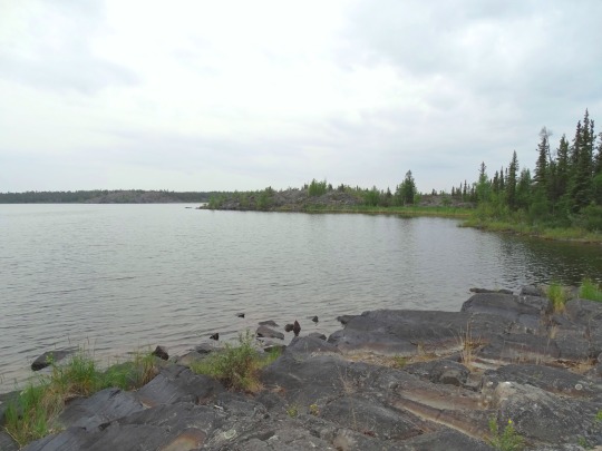


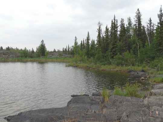
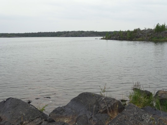
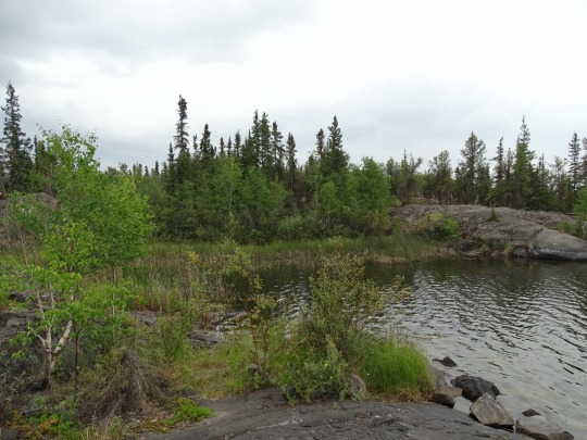

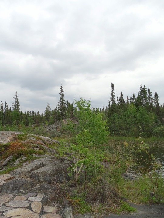
Yellowknife, NWT (No. 9)
Frame Lake is irregularly shaped, with a northern section and a southern section along a north-northeast to south-southwest axis approximately 1.4 kilometres (0.87 mi) long, connected by a narrower central passage midway along its length where a wide peninsula extends from the western shore and an arm extends roughly 500 metres (1,600 ft) to the east, curving northward. At their widest shorelines, both sections are roughly the same distance apart. Five small islands are located within the lake, three in the northern section and two in the southern section. Its total surface area is 84 hectares (210 acres).
The lake lies at an elevation of 186 metres (610 ft). Surrounding terrain is gently undulating, with some of the small hills nearby cresting as high as 207 metres (679 ft) and one of the islands rising to 197 metres (646 ft). Two unnamed streams drain into the lake south of the peninsula on the western side. The northerly of the two rises from drainage ditches surrounding the runways at Yellowknife Airport 1.6 kilometres (1.0 mi) to the west, draining Robinson's Pond on the way to Frame Lake; the southerly has largely been channelized, draining Range Lake 600 metres (2,000 ft) to the west, itself fed by a stream of similarly short length flowing into it from the west.
Source: Wikipedia
#Frame Lake#Yellowknife#NWT#Northwest Territories#nature#travel#original photography#vacation#tourist attraction#landmark#landscape#Canada#summer 2024#cityscape#the North#Canadian history#rock#forest#Canadian Shield bedrock#trail#bench
18 notes
·
View notes
Text
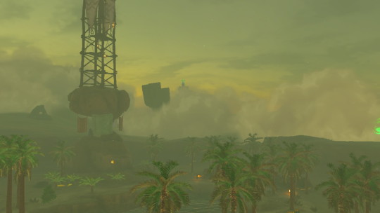
Day 83: Gerudo Desert, and Riju
From here, the desert looks foggy. Perhaps a sand storm? I hope it clears before I need to head to Gerudo Town. I spot two other things of note: the tower in the Highlands, and a geoglyph. It looks like a figure of some kind. Could I glide all the way there? It looks far…
No. But I at least get on the right level of the Highlands. It's even colder up here. I find the geoglyph.
A vision. I see...

Ganondorf swears loyalty to the King of Hyrule. The conversation is tense.

This vision is different - as they talk, I feel I'm following Ganondorf's eyes specifically. Examining each secret stone on display, ignoring their bearers. Resting again on Sonia's. I have already seen the Queen's fate.
Zelda is concerned. Even his name… I understand her hesitancy, and I share it. Rauru is foolish to reassure her. Everything could have been prevented if Ganondorf had been stopped here. Rauru was right. He was an arrogant king. So sure none could unseat him.
It's so cold. I have to keep moving. I consider leaving the tower for another day, but I'm halfway there now.

I glide over what must be the old Yiga Clan hideout - I wonder if they still use it? That map in Robbie's lab suggested yes.
I reach the tower. There's a little tent - the journal belongs to Billson. The tower is snowed in… fortunately, it sounds like there's a cave somewhere below.
Meadella's Mantle Cave. I wonder if this is it? Billson's records suggest the cave does go under the tower - but also that it's massive. There's a river flowing through it - I chuck a wooden board into it and climb on.
Bubbulfrog! By complete chance, I manage to land its gem on my rudimentary raft as it lands at the bottom of the waterfall.
The raft takes me perfectly under the tower. And launch!

I try to glide to a southerly sky island to hop over to Gerudo Town - but it turns out to be inhabited by a three-headed dragon, so we won't go there. I redirect to the plateaus around the old Sheikah Tower site, which is now a chasm to the Depths. The desert is engulfed by a sand storm. Can I make it to Gerudo Town from here? I feel like I should try.
I barely get as far as the ruins before I completely lose visibility. I can hear these huge impacts, like explosions. There's a trio of… guards? No, training dummies. And the impacts flash like lightning. I know who's here - I rush to find her.

Riju.

She recognises me still - it's good to find a friend. She says this sand shroud appeared when Hyrule Castle rose - that tracks. And there are new monsters - gibdos. We work out a technique which might be useful against them - I aim, and Riju shoots lightning.
And then golden light fills the air… the Gerudo sage is watching us.

Another Gerudo, Faundi, arrives. She says gibdos are attacking Kara Kara Bazaar. We have to go there. But… how can I find my way in this??
I climb a piece of ruin, intending to guess and glide - but it's high enough that I can see across the sand shroud, thank goodness. Aiming for the bazaar is still a guess, but it's slightly more informed.
I almost lose my way once I glide back below the horizon, but I make it to Kara Kara Bazaar and help Riju fight off the gibdos. Awful creatures, long-limbed and half-rotten, with insectoid faces and gill-like necks.

I think I saw some through the sand storm on my way here. I'm glad I didn't have to fight them without Riju. There's some kind of weird mushroom that glows, seemingly the source of the gibdos or their power.
Suddenly, through the sand - Zelda!
No, it can't be. It must be the imposter. Coincidentally, right at that moment, tornadoes head for Gerudo Town.
Riju heads back that way. I want to see if anyone I know is in the Bazaar before I join her.
Also, I need to stop at the shrine here.
15 notes
·
View notes
Text
A Journey Through Norway
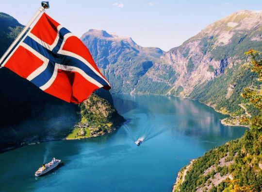
Norway, officially the Kingdom of Norway, is a nation in northern Europe's western Scandinavian Peninsula. Svalbard and Jan Mayen are included in the 148,449 sq mi (384,483 sq km) total area. Estimated population in 2023: 5,526,000. Norwegian capital. Although there are various ethnic minorities, including between 30,000 and 40,000 Sami (Lapps), the majority of the population is Norwegian. Norwegian and Sami are the official languages. Religion: Christianity (officially, Evangelical Lutheranism is the predominant form). currency: krone of Norway. Norway is one of the biggest nations in Europe. It is a hilly country with substantial plateau areas in the southwest and center. It has a developed economy mostly centered on services, petroleum and natural gas extraction, as well as light and heavy industries. Historically a fishing and logging country, it has considerably grown its mining and industrial operations since World War II. Literacy is almost universal.
Norway is a constitutional monarchy with a single parliamentary chamber; the king serves as the country's head of state, while the prime minister serves as the head of government. In the eleventh century, a number of principalities were combined to become the kingdom of Norway. From 1380 until 1814, when it was given to Sweden, it shared a ruler with Denmark. When the union with Sweden was broken up in 1905, Norway's economy expanded quickly. Despite the fact that its shipping industry was crucial to the war effort, it stayed neutral throughout the fight. Despite having declared itself neutral during World War II, German forces invaded and seized the area. Norway is a member of NATO and maintains a robust welfare system. In 1994, its citizens rejected joining the European Union.
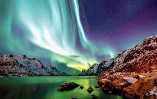
Northern lights, Norway
The stark natural beauty of Norway has drawn tourists from all over the world. Other notable artists from the nation include playwright Henrik Ibsen, composer Edvard Grieg, painter Edvard Munch, writers Knut Hamsun and Sigrid Undset, and composer Edvard Grieg. Ibsen made the following observation about his own land and its reflective citizens: "The gorgeous, but severe, natural environment surrounding people up there in the north, the lonely, secluded life—the farms are miles apart—forces them to...become introspective and serious. At home every other person is a philosopher!"
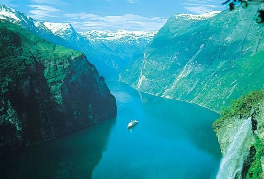
Fjord, western Norway
Westward flowing rivers had a powerful erosive force. They carved out gorges and canyons that sliced deeply into the rugged coast, following fracture lines denoting weak spots in the Earth's crust. The terrain slopped more gently to the east, creating wider valleys. The magnificent U-shaped drowned fjords that now adorn the western coast of Norway were created by glaciers tonguing down the V-shaped valleys that were part of the landscape during repeated periods of glaciation in the Great Ice Age of the Quaternary Period (i.e., roughly the last 2.6 million years). Glacial action also transported enormous quantities of soil, gravel, and stone as far south as modern-day Denmark and northern Germany. The bedrock, which is exposed in roughly 40% of the area.
Climate of Norway
Although it occupies almost the same degrees of latitude as Alaska, Norway owes its warmer climate to the Norwegian Current (the northeastern extension of the Gulf Stream), which carries four to five million tons of tropical water per second into the surrounding seas. This current usually keeps the fjords from freezing, even in the Arctic Finnmark region. Even more important are the southerly air currents brought in above these warm waters, especially during the winter.
The mean annual temperature on the west coast is 45 °F (7 °C), or 54 °F (30 °C) above average for the latitude. In the Lofoten Islands, north of the Arctic Circle, the January mean is 43 °F (24 °C) above the world average for this latitude and one of the world’s greatest thermal anomalies.
Western Norway has a marine climate, with comparatively cool summers, mild winters, and nearly 90 inches (2,250 mm) of mean annual precipitation. Eastern Norway, sheltered by the mountains, has an inland climate with warm summers, cold winters, and less than 30 inches (760 mm) of mean annual precipitation.
Cultural institutions
Permanent theatres have been established in several cities, and the state traveling theatre, the Riksteatret, organizes tours throughout the country, giving as many as 1,200 performances annually. The Norwegian Opera, opened in 1959, receives state subsidies (as do most other theatres).
In addition to its National Art Gallery, Oslo opened a special museum in 1963 to honour Edvard Munch, credited as one of the founders of Expressionism and as Norway’s most famous painter. The Sonja Henie–Niels Onstad Art Centre, opened in 1968 near Oslo, contains modern art from throughout the world. Oslo is host to many other museums, including the Ibsen Centre, which honours the famed playwright, and the Resistance Museum, which documents Norway’s struggle against Nazi occupation during World War II. Outside Oslo, the Tromsø Museum’s collection records Sami heritage.
EXPENSES
The expenses for traveling to Norway from the Philippines can vary widely depending on factors like the duration of your stay, type of accommodation, activities, and personal preferences. Here are some estimated costs to consider:
Flights: The cost of round-trip flights can vary depending on the time of booking, airline, and travel dates. On average, you might spend between $800 to $1,500 or more.
Accommodation: Accommodation costs can vary from budget hostels (around $40-$100 per night) to mid-range hotels ($100-$250 per night) and luxury hotels ($250+ per night).
Food: Dining out in Norway can be expensive. Expect to spend around $20-$50 for a meal at a mid-range restaurant. You can save money by eating at more budget-friendly places or preparing your own meals.
Transportation: Local transportation in Norway, such as buses and trams, can be costly. A one-way ticket might cost around $3-$4. If you plan to travel between cities, train or bus tickets will vary in price.
Activities: The cost of activities and attractions can vary, but expect to spend on average $20-$50 per attraction or activity.
Travel insurance: Consider the cost of travel insurance to protect yourself during your trip.
Visa fees: If you need a visa to enter Norway, there may be associated fees.
Miscellaneous: Don't forget to budget for souvenirs, additional personal expenses, and unforeseen costs.
Overall, a moderate daily budget for a comfortable visit to Norway can range from $100 to $200 or more, depending on your spending habits and travel style. Be sure to plan and budget according to your specific travel plans and preferences.
ENJOY YOUR JOURNEY TO NORWAY
Reference:
Charles Jays, Gudmund Sandvik, Jorgen Weibull & The Editors of Encyclopedia Britannica (2023).
https://www.britannica.com/biography/Harald-I-king-of-Norway
# Travel # Create New Journey # Photography # aesthetic
4 notes
·
View notes
Text
Vortex Variety Hour
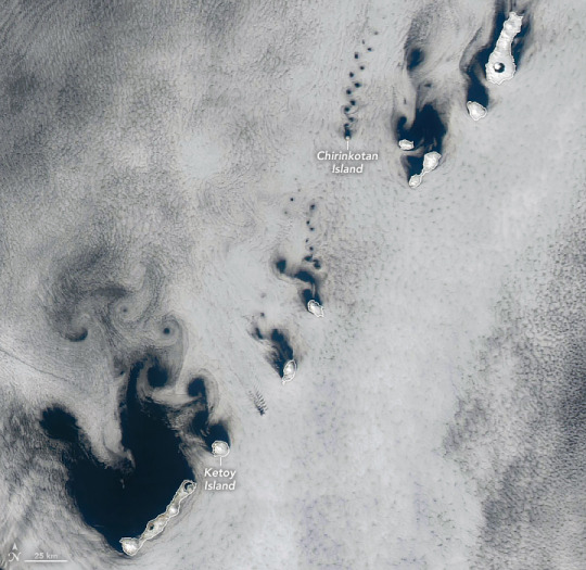
Winds blowing across the Kuril Islands, between northern Japan and Russia’s Kamchatka Peninsula, sent clouds spinning into compact coils and sprawling swirls on a spring day in 2025. The MODIS (Moderate Resolution Imaging Spectroradiometer) on NASA’s Aqua satellite captured this image of the vortices on April 14, 2025.
The trails of staggered, counterrotating spirals are called von Kármán vortex streets. This distinctive pattern can occur when a fluid passes a tall, isolated, stationary object. If winds are too weak, clouds simply flow smoothly around the obstacles. If they are too strong, vortices break apart and cannot maintain their shape. In the sweet spot, typically between 18 and 54 kilometers (11 and 34 miles) per hour, the clouds will reveal details of the airflow.
The cloud streets take on different orientations across the length of the archipelago, indicating wind directions that vary from southeasterly to southerly. Also note how the vortices are sized in proportion to the diameter of the islands that created them. At only 3 kilometers (2 miles) wide, Chirinkotan Island in the upper right of the image produced diminutive whorls to match. Near the center of the image, Ketoy Island has a diameter of approximately 10 kilometers (6 miles), and larger vortices trailed in its wake. Vortices tend to grow larger and diverge as they continue downstream.
The image also shows organized vortex streets appearing downwind of islands that are more rounded than elongated. In the built environment, engineers and architects know that tall, cylindrical structures can also shed von Kármán vortices in the right conditions. The process can exert damaging forces on structures, but devices such as dampers and fins can be used to counteract them.
NASA Earth Observatory image by Michala Garrison, using MODIS data from NASA EOSDIS LANCE and GIBS/Worldview. Story by Lindsey Doermann.
1 note
·
View note
Text
Ditches, canals and aqueducts of Mexico City
You can also listen to this chapter in audio This time we are going to see the description of the acequias canals and aqueducts of Mexico City a little more in detail and one by one, to understand more about how they worked and what was their route. These are the most important irrigation ditches that were part of Mexico City. Santa Ana-Santa Isabel Ditch The name of this distinguished ditch did not originate, as is often presumed, in homage to a Most Serene Highness, but by virtue of one of its branches that flowed north of the venerable temple of Santa Ana Atenantitech. From the crossroads of Flores Magón, this water current flowed southward, crossing the area of Eje Central, where several notable bridges were erected. Among them were the Puente de las Guerras (where it branched into two arms), the Puente de los Angeles, the Puente de Santa Maria, the Puente del Zacate (also known as Peru), the Puente de Villamil, the Puente Juan Carbonero and the famous Puente de la Mariscala, located on Hidalgo Avenue, right in front of the Convent of Santa Isabel, today known as the majestic Palacio de Bellas Artes. Following its course, this irrigation channel crossed the San Francisco Bridge (located at the intersection of Juárez and Madero) and culminated at the Hospital Real Bridge, located at the intersection of Venustiano Carranza and Artículo 123, where it ended, joining its flow with the Acequia Real. It also marked the northern limits that divided the city from Santiago Tlatelolco, through a branch that entered to the east, winding through the neighborhoods of Peralvillo and Tepito along Matamoros Street. The bridges that crossed this ditch include the Santiago Bridge (formerly known as Allende), the Tecolotes Bridge (known as Comonfort), the Santa Ana Bridge (located in Peralvillo) and the Chirivitos Bridge (located in Jesús Carranza). Subsequently, it merged with the Acequia de Zorrilla before reaching its final destination at the Compuerta de Tepito. Unfortunately, however, in the year 1882, this venerable acequia was sealed, marking the end of its historical legacy in the city. San Pedro and San Pablo Ditch An ancient watercourse that flowed from Tezontlale and connected with the Acequia del Carmen arouses our historical curiosity. This stream of water, after crossing the convent in a southerly direction, meandered gracefully between the buildings until it reached Girón, where it crossed over the iconic San Sebastián (formerly known as Bolivia) and Cuervo (renamed Colombia) bridges. At its final crossing, it took a turn to the west and ended at the San Pedro and San Pablo Bridge, marking the limits of the Colegio Máximo at that time. This narrative transports us back in time, revealing the intricate network of irrigation ditches that once irrigated the city, and how these historic waterways shaped its urban landscape. Acequia del Carmen South of Tezontlale, we discovered the fascinating Acequia del Carmen, named in honor of its proximity to the plaza of the Convent of the Barefoot Carmelites. This riverbed emerged from the west, along Violeta Street, and then, after crossing Santa María at the point where the Zacate Bridge stands, continued its path along República de Perú, right in front of Plaza de Montero, a short distance from Plaza del Jardín (later known as Garibaldi) and the vibrant neighborhood of La Lagunilla. Following the direction from west to east, the current Republic of Peru was composed of different segments such as Cerca de San Lorenzo, Espalda de la Misericordia, Puerta Falsa de Santo Domingo, Pulquería de Celaya and Apartado. Along its route, it crossed under several notable bridges such as the Misericordia Bridge (also known as Allende), the Santo Domingo Bridge (identified as Brazil), the Leguísamo Bridge (called Argentina) and the Carmen Bridge (known as Carmen-Aztecas). Further on, after passing by the old Apartado building, which today houses the National Numismatic Museum, I arrived
in front of the Convent del Carmen square, which was famous for its fountain and the statue in honor of Miguel Hidalgo, although today this space is occupied by the Abraham Castellanos Elementary School, next to another wide square called La Concordia. Continuing towards the east, it crossed the Cantaritos Bridge (renamed Torres Quintero-Florida), located in the modern Manuel de la Peña y Peña, and a few hundred meters further on it reached the San Sebastián Gate. It is important to note that the section that extended from Santa María to the Carmelite convent was sealed in 1794, and ninety-two years later, the eastern segment of the irrigation ditch also suffered the same fate. This story allows us to appreciate the rich history that lies in the bowels of the city. Tezontlale Ditch (Tezontle, Tezontlali) The historic Acequia de Tezontlale (also known as Tezontle or Tezontlali) flowed majestically from west to east, winding through the city of yesteryear. Its course took it between two cemeteries that no longer exist, Santa Paula to the south and San Andrés to the north, in the picturesque neighborhood of Santa María la Redonda-Cuepopan. This water serpentine crossed the renowned Calzada de Santa María (known today as Eje Central), changing its name to Puente de las Guerras (Bridge of Wars) at the crossing with the irrigation ditch, in commemoration of the bridge that was erected over it. Later, the ditch entered the city through Calle de Órgano, passing under the iconic bridges: Puente del Clérigo (also known as Allende) and Puente de los Esquiveles (called Carrizo-Comonfort), to then join Eje 1 Norte in the vicinity of Puente de Tezontlale (today known as República de Brasil). On its way, it passed through the Callejón de los Puentecitos (today known as Callejón Ecuador) and crossed the Puente Blanco located on Calle del Relox (today Argentina), right in the current location of the Porrúa Bookstore, near the majestic Templo Mayor. Upon reaching the point where Ecuador Street became Costa Rica, right in front of the current Granaditas Market, the irrigation ditch entered a scarcely urbanized area, at least until the middle of the last century. At the corner of Florida Street, it merged with the Acequia de Zorrilla. Unfortunately, however, in 1882, the flow of Tezontlale was interrupted, marking the end of an important part of the city's history. Monserrat Ditch (Monserrate, Montserrat) Emerging a few meters from the corner of Toribio-Cruz Verde (known as Izazaga) and Monserrate (at Isabel la Católica), was the enigmatic Acequia we want to talk about. This very ancient waterway entered the southern indigenous periphery through an alley that unfortunately has disappeared over time. Its route took it to cross Nezahualcóyotl Street, joining Isabel la Católica Road, in the middle of the settlements of San Salvador el Seco to the west and San Salvador el Verde to the east. After crossing the Carretones Bridge, the irrigation ditch took a turn to the southeast and entered the Rinconada de la Chinampa (a street that has been forgotten with the creation of Fray Servando), located within the neighborhood of El Verde. Its route continued until it reached Necatitlan (on today's 5 de Febrero), near Tlaxcoaque, where it joined the Acequia de Xoloc-Chimalpopoca-San Antonio Abad, which in turn connected with the Acequia de Roldán to the east. During the rainy season, this area was transformed into a vast chinampera swamp, reminding us of the importance of water management in the history of the city. In addition to the Acequia de la Merced-Regina, other acequias played fundamental roles in the urban fabric. The non-navigable Acequias were part of the colossal project known as the Zanja Cuadrada, a late novo-Hispanic construction designed in part for fiscal and defensive purposes. These ditches included that of San Diego, which alternated between canal and ciénega, and was notorious for being the place where the ashes of those executed by the Inquisition were thrown.
There were also those in the neighborhoods of Niño Perdido and Candelaria de los Patos, which were home to these migratory birds, as well as the Acequia de Santa Veracruz and the lateral ditches that delimited the Paseo de Bucareli. The irrigation ditches were late witnesses of the ancient lacustrine features of this metropolis, whose understanding cannot ignore its profound relationship with water. Their disappearance not only meant the loss of commercial, urban and road elements, but also the disappearance of identifying features of the neighborhoods and their inhabitants, whose origins date back to the 14th century. However, sometimes, during the rainy season, the water returns to flood the sidewalks and streets, reminding us that the city still holds in its heart a nostalgia or fear for its aquatic past. Acequia de la Merced-Regina One of the historic "interior" irrigation ditches that ran through Mexico City was the Merced-Regina, whose origin was at the southern end of the Acequia de Santa Isabel. This water channel traced a meandering route through the streets and neighborhoods of the city, leaving its mark on the urban fabric. Starting on Zuleta Street, the irrigation ditch took a turn to the southeast, crossing blocks and emerging on Ortega Street (today known as Uruguay). Then, it passed through the corner where the Puente Quebrado (Salvador) Bridge used to stand, connecting with Ratas (Aldaco) Street and continuing towards the corner of Mesones and Bolívar. It reached Regina, near the Convent of Regina Coeli, and advanced almost to the corner of Tornito de Regina-San Jerónimo, ending its route at the Puente del Monzón (Isabel la Católica), where the Casa de la Acequia is located today. At this crucial point, three irrigation ditches intertwined: the Merced, the Chapitel (heading west) and the Monserrat (heading southeast). The Merced irrigation ditch followed its course northeast towards the Merced neighborhood, crossing Isabel la Católica Street and entering the bridges of Aduana Vieja (5 de Febrero and Regina), de Jesús (located on Mesones, almost on the corner with Pino Suárez, in front of the hospital of the same name), Balvanera (on Correo Mayor, on the corner with Salvador) and then entering the properties between the Correo Mayor-Las Cruces block. Finally, it reached the corner of Puerta Falsa de la Merced (Uruguay) and Fierro Street (Jesús María, a few meters from the Convent of La Merced and the temple of San Pablo). The irrigation ditch continued its course eastward in a straight line along Uruguay Street until it reached the Santiaguito Bridge, where it met the Roldán irrigation ditch. A few blocks away, between Uruguay and Manzanares, the canal entered again between the houses, crossing the alley of Santo Tomás to reappear in Manzanares, in front of the church of Señor de la Humildad. Its route continued northeast, winding through the houses and crossing the Rosario Bridge (at the corner of Corregidora and Rosario) until it reached its final destination at the Zanja Cuadrada (in Congreso de la Unión), south of the Garita and the Compuerta de San Lázaro. This story allows us to appreciate the complex network of irrigation ditches that once crossed the city, leaving their mark on its historical development.
0 notes
Text

Precipitable Water map tomorrow Tuesday for the SE here. Shift in the Bermuda High eastward allows more southerly flow and the classic sea breeze collision. Middle to western peninsula looking a little juicy. www.spaghettimodels.com
0 notes
Text
Forecast Discussion
Product: Forecast Discussion Issued: 2025 Apr 16 0030 UTC Prepared by the U.S. Dept. of Commerce, NOAA, Space Weather Prediction Center Solar Activity .24 hr Summary... Solar activity has been at moderate levels due to multiple M-class (R1-Minor) flares. The location of the M1.5 at 15/1020 UTC is difficult to deduce as two flares, of what look like similar magnitude, occur at the same time on the eastern and western limbs. The flare on the east limb around N09 seems to peak at 10/1020 while the west limb flare associated with departing Region 4055 (N07, Lo=237) peaked at 10/1029. The GOES X-ray sensor only observed one peak during this window. The second largest flare of the period was an M1.3 flare at 15/1813 UTC from Region 4055. Region 4060 (N08W03, Dai/beta-gamma) experienced minor growth in its trailer but has been stable otherwise. Region 4062 (S02E61, Dao/beta) continues to come into better view but the magnetic field is still obscured by foreshortening to be confident in its classification beyond beta. There was a CME observed in LASCO/SOHO imagery around 15/1500 UTC. But based on its source location being beyond the eastern limb impacts are not expected. .Forecast... With 4055 now beyond the western limb, probabilities for M-Class (R1-R2, Minor-Moderate) radio blackouts will decrease from 75% to 50% into 18 Apr. However, probabilities may increase if the region beyond the eastern limb around N09 remains active. All four numbered regions on the disk are fairly simple in their magnetic complexity keeping the chances for X-class (Strong) flare activity very low (5%). Energetic Particle .24 hr Summary... The geoeffective positioning of the high speed stream (HSS) associated with the negative polarity coronal hole (CH) in the southern hemisphere has maintained high electron flux at geostationary orbit for multiple days. The greater than 2 MeV electron flux at the GOES-19 satellite position saw a peak flux of 2380 pfu at 15/1620 UTC with the GOES-18 peaking to 5120 pfu at 15/1750 UTC. The greater than 10 MeV proton flux has been at background. .Forecast... HSS influence from the southerly CH will diminish into 16 Apr with potential reconnection with the HSS from the northerly CH 17 Apr. This will increase chances for the greater than 2 MeV electron flux to remain high during the diurnal maxima through 18 Apr. Barring any significant flares from Region 4055 which will remain in a favorable position into 16 Apr, the greater than 10 MeV proton flux is expected to remain at background levels. Solar Wind .24 hr Summary... Solar wind parameters became enhanced at 15/1637 UTC following the arrival of the shock arrival with the CME that left the Sun on 13 Apr. The total interplanetary magnetic field (Bt) reached a maximum of 28.2 nT around 15/1820 UTC, the north-south component (Bz) dropped to a minimum of -20.3 nT at 15/1815 UTC. Wind speeds increased from 400 km/s prior to CME arrival to 554 km/s as of this writing. The phi angle has been variable with the southerly Bz magnetic field embedded in the negative (towards the Sun) flow. Both ACE and DSCOVR have been capturing the event well. A switch was made between the primary satellites around 1830 UTC from DSCOVR to ACE, producing a discontinuity in the density field. .Forecast... Solar wind parameters will remain enhanced 16 Apr due to ongoing influences from the current CME. Effects will wane 17 Apr but parameters will continue to be elevated as the equatorial negative polarity CH becomes geoeffective 17 Apr. Geospace .24 hr Summary... The geomagnetic field was at quiet to unsettled levels for most of the UTC day. CME arrival at 15/1637 UTC enhanced the geomagnetic field to G1 (Minor) storming levels during the 15-18 synoptic period and G2 (Moderate) storming levels in the 18-21 period. .Forecast... Geomagnetic storming is expected to continue through much 16 Apr with G3 (Strong) levels likely. CME influences will wane with G1 (Minor) levels likely to continue on 17 Apr. Expect active to unsettled conditions thereafter. -Bri
#Forecast Discussion#SWPC#Space Weather Prediction Center#Space Weather#NOAA#Aurora#Aurora Forecast#Northern Lights#Northern Lights Forecast
0 notes
Text
Tornado Threat for LA/MS Delta

Been watching the model trends throughout the day yesterday and decided to wait until this morning to write this blog regarding the tornado threat across the Louisiana, Arkansas into Mississippi. As of this morning, the SPC has issued a 10% tornado risk that is concentrated along the MS RVR and extends to along I-55. Everyone else within the severe weather risk is either in the 2% (in green) or a 5% risk (in brown) across the severe weather risk area. This discussion will be primarily focus within the 10% risk area as that is not only the best chance for tornadic storms, but also the best chasing area within the state of MS and the sate of LA.

Starting off with the current synoptic conditions, the mid-level trough is still hanging back over in northern TX into southern OK as of this morning. This trough is expected to progress into Arkansas during the morning hours into the early afternoon hours. With the mid-level jet, the is a jet max sitting right at the base of the trough. This jet max within the mid-level will gradually start to move towards the eastern side of the trough, however is not forecasted to dig any further south will be focus within eastern OK into western AR. This could potentially limit any supercell development, but does not mean the tornado threat itself will be limited in any way.

As the morning progresses, the low-level jet is expected to strengthen through out the day which in turn provide enough low-level shear for storms to take advantage later this afternoon into the evening hours. Model guidance showing 45 to 60 knot low-level jet in place for much of the risk area which is more than sufficient for storms to become tornadic. This also could make keeping up with storms a headache if I decided to go storm chase today as well, which is one of many factors I am taking into consideration this morning.

As far as the movement of the warm front and cold front, despite what the temps might currently across the risk area, there will be a significant warming during the course of the day. This warming will allow for both an unstable environment and moisture to be present across the region with southerly wind flow. The concern will how warm will it get across the area? Right now, temps are expected to reach the mid-60s into the lower 70s. Would typically like to low to mid-70s for tornadoes, but given time of year and the other synoptic features at play this will be more than sufficient for the tornado threat. Will also need to watch how fast the cold front does come through as it could speed up the timing and even could further limit any supercell development within the warm sector.

As far as storm environment will go, model guidance showing the environment will struggle to reach a 1,000 J/KG across a large portion of the severe weather risk. Again this does not mean the tornado threat will be zero, this means any discrete storms that do develop, could struggle, especially if they are developing within the same region and fight over the same energy. Also, this typical for the region of seeing low CAPE environments and especially for this time of year. The forecast sounding above is a little aggressive on the CAPE, but it does show the "potential" setup that we could be looking this afternoon.
Secondly, the SRH values suggest that there is more than enough shear in place and this has been the one parameter that has not changed across the tornado risk area. This is due in large part of the low-level jet.
The final two parameters to pay attention to in the forecast sounding is the wind profile as it turns from southeasterly to the west with height and the looping hodograph in the top right-hand corner. Both of these suggest the wind vectors are more than favorable for tornadic storms.

As far as timing and storm mode, this is where it becomes the two big factors for me. First timing is nearly perfect as these storms will be occurring during the daylight hours and will provide more than enough light to see and chase without having to worrying to much about darkness and limited visibility.
Storm mode, based on morning data, this remains a decision. While model guidance shows one or two discrete cells, they will end up merging with the line fairly quickly. Also the development of the cells will be along the leading the edge and will not give me enough head room to reposition and could make it tough in seeing the actual tornado, especially if it develops behind the rain.
Model guidance does show the potential of a discrete cell or two developing along I-55, but that will be a no go for two reasons. One, chasing on the interstate is not a good idea, especially with the limited road network in the region. Two, the trees and hills will block my view of any potential storms that could develop and is not worth the risk for me.
With that said, the chase status for now is consider standby and see how model data and environment will evolve throughout the day, but as of right now, it does not look like a good day to chase with the main action being within the line and not with the discrete cells.
0 notes
Text
a poem for my friend
i hate the look in his eyes when i tell him to take care of himself. that stupid half smile on his lips, the way i can tell he doesn't think himself worth care. he doesn't think himself worth saving.
when he speaks i can hear his heartbeat- irregular, jerky, beating out a funeral march. the uncanny throbbing rhythm flows with our conversation, quickening, changing with the tempo of the music and the bitter southerly winds. i do love him, despite my best efforts. despite the half-bullshit stories he tells me about LSD and beautiful girls, despite my ill-tempered objections and disdainful speeches.
i hate it when he tells me he's been doing okay as if we can't both smell the putrid half-human stench, see the crimson blossoming from his chest. the bright red compliments the blues and yellows of the paint smeared over his shirt perfectly, a beautiful kaleidoscope blanket resting on the skeletal figure of a hungry street dog who stands shaking but earnest at my feet.
i hate how i can't save him from the burning house he lives in. the rent's a steal, he says, and he's used to excess smoke. i refuse to sit nearby and warm my hands. i'll bang on the windows and scream his name until my throat is raw and my palms are weeping red wine cascades, and i'll see him inside lighting a cigarette on the flames that lick his thighs and staring blankly in the mirror through the haze of smoke. i hope he'll see me over his shoulder and smile.
his stupid little half smile as the funeral march gets softer and softer.

0 notes
Text
West-central Florida faces its most significant hurricane threat in over a century.
The FOX Forecast Center warns that communities in the Tampa metro area, which have only experienced glancing blows from hurricanes in recent decades, now face the risk of a direct hit. This could lead to a significant storm surge along the vulnerable coastline.
Less than two weeks after Hurricane Helene hit Florida’s Big Bend, Milton is now threatening to follow a similar path. However, due to the state's unique coastline, the angle of landfall could make this storm the worst in over a century for parts of west-central Florida.
Climate and Average Weather Year Round in 34210 - Bradenton FL:

flickr
The region is already weary from recent storms, including Helene, Debby, Ian, and Idalia. But the FOX Forecast Center warns that the storm’s unusual approach resembles the scenario emergency managers have long feared and prepared for.
During Helene, areas south of Florida's Big Bend saw storm surges averaging 5 to 8 feet, which were relatively modest due to the wind direction and distance from the core of the Category 4 hurricane. A storm track that moves directly over or just north of the Tampa-Sarasota metro would result in a much greater storm surge than previous hurricanes.
"The West Coast of Florida is extremely vulnerable to storm surge, as we've seen in the past. Even a tropical storm can push Gulf waters to dangerous levels, and a strong hurricane poses an even greater threat. It’s vital for everyone in Central and South Florida to stay informed, as conditions are changing rapidly," said FOX Weather Hurricane Specialist Bryan Norcross.
A storm surge model known as SLOSH predicts that during a Category 3 hurricane, large portions of Hillsborough, Pinellas, and Pasco counties could be submerged under several feet of water. The area's shoreline topography means water levels could rise by more than 9 feet if a major hurricane follows the worst-case scenario for the metro region.
Storm trajectories significantly north or south of the Tampa metro result in drastically different outcomes, as many Floridians have experienced in recent years. Weather Forecast For 80908 Colorado Springs CO:
https://www.behance.net/gallery/202610237/Weather-Forecast-For-80908-Colorado-Springs-CO
For instance, Hurricanes Idalia and Helene made landfall about 130 miles north of Tampa, generating storm surges of 3 to 8 feet around the metro, partly due to the southerly winds.
Conversely, Hurricane Ian in 2022 caused a northeast wind flow when it made landfall near Fort Myers. This resulted in a negative storm surge in Tampa Bay, with water levels dropping by 5 to 8 feet.
Some residents were even seen walking along the exposed lakebed, though it was a risky and ill-advised decision.
Emergency managers have long planned for a worst-case scenario in the Tampa metro area. While the exact impacts of Hurricane Milton won’t be known until it passes through Florida, preparations for a direct strike have been in place for years.
In 2009, the Tampa Bay Regional Planning Council created "Project Phoenix," a simulation that modeled the effects of a Category 5 hurricane hitting the region. The hypothetical storm generated a storm surge of up to 40 feet along the coast, with downtown Tampa experiencing water levels rising 10 to 15 feet.
The projected damage was estimated in the hundreds of billions of dollars, potentially making it the most expensive disaster in U.S. history if such a storm were to occur.
youtube
While no one, including the National Hurricane Center or various computer models, is predicting Milton will reach Category 5 strength, there is historical precedent for a Category 3 storm impacting the region.
In 1921, the Tampa Bay hurricane formed in the Caribbean and made landfall near Tarpon Springs as a Category 3 storm with winds around 120 mph. According to the National Weather Service, the storm generated a surge of about 11 feet, and records show that only eight lives were lost.
At that time, the Tampa Bay metro area had a population just over 100,000. Today, census estimates place the population at more than 3 million, drastically increasing the potential impact of a similar storm.
In more than 180 years of record-keeping, Tampa has only been directly hit by two major hurricanes: the Category 3 storm in 1921 and a Category 4 in 1848.
See more:
https://weatherusa.app/zip-code/weather-80138
https://weatherusa.app/zip-code/weather-80150
https://weatherusa.app/zip-code/weather-80151
https://weatherusa.app/zip-code/weather-80155
https://weatherusa.app/zip-code/weather-80160
0 notes
Text
SPC Day 1 Fire Weather Outlook
SPC Day 1 Fire Weather Outlook https://shelbyohwx.com/X/wp-content/uploads/day1fireotlk-1.gif"/>

SPC Day 1 Fire Weather Outlook
Day 1 Fire Weather Outlook NWS Storm Prediction Center Norman OK 1158 AM CDT Fri Aug 23 2024 Valid 231700Z - 241200Z ...CRITICAL FIRE WEATHER AREA FOR PORTIONS OF THE GREAT BASIN... The Isolated Dry Thunderstorm highlights were expanded into southwest Montana, where forecast soundings suggest the potential for fast-moving, high-based thunderstorms over modestly receptive fuels this afternoon. Some of these storms will be capable of producing severe wind gusts (around 60 mph), aided by enhanced deep-layer flow/shear and deep inverted-V thermodynamic profiles. For details on the severe-thunderstorm risk, see the SPC Day 1 Convective Outlook. Additionally, the Critical area in the Great Basin was expanded slightly eastward and southward, where the latest high-resolution guidance has increased confidence in the overlap of 20-30 mph sustained southerly surface winds and single-digit to lower-teens RH. Over portions of the southern Plains, very hot and dry conditions will develop this afternoon, which combined with breezy/gusty southerly surface winds, may promote locally elevated fire-weather conditions. There will also be some potential for an isolated lightning-induced ignition with thunderstorms over north-central TX. Overall, the fire-weather risk across this region appears too localized for highlights. ..Weinman.. 08/23/2024 .PREV DISCUSSION... /ISSUED 0144 AM CDT Fri Aug 23 2024/ ...Synopsis... A mid-level trough will enter portions of the Pacific Northwest, with enhanced mid-level flow overspreading portions of the Great Basin and vicinity. Afternoon heating/mixing will result in sustained surface winds of 20-25 mph while RH values drop into the teens, resulting in Elevated to Critical fire-weather conditions for this region. In addition, forcing for ascent associated with the aforementioned trough will allow for thunderstorms to develop across the Pacific Northwest, with a mix of wet and dry storms expected. Given dry/receptive fuels across the region, the area delineating isolated dry thunderstorm potential has been maintained. ...Please see www.spc.noaa.gov/fire for graphic product...
Read more
#ohwx #OHWweather #shelbyoh
0 notes
Text
I'm still kind of annoyed.
My grade four teacher to the rest of the class: Which way do you think the Murray River (which forms most of the northern border of Victoria) flows?
Me: East.
Teacher: No, although it looks like it should flow down the page because of gravity, doesn't it?
Me: *never got the chance to explain that that isn't why I had come to the wrong conclusion, that I had assumed the river flowed into the Pacific Ocean because I knew there was land to the west of the state*
I didn't realise that the river doesn't actually reach the east coast, that the westernmost part of the Victoria/NSW border is an arbitrary (straight) line that doesn't follow any waterways.
I didn't realise the Dividing Range was in the way
I didn't realise that the river mouth is in South Australia.
I did realise that "south is down" is arbitrary and that gravity does not act southerly. Aargh.
0 notes
Text
Trip 19 Carp Fishing - 2024
With my gardening jobs done for this week and the weather conditions completely different from last week’s heatwave, I thought it best to head down to the lake early Tuesday evening, giving me three nights at my disposal, if I felt it was worth it. The forecast was pretty good, with low pressure and a southerly wind. There was still a lot of freshwater flowing in off the forest, especially after…

View On WordPress
0 notes
Text

Hello readers,
Working on two works of fiction on Royal Road: (a) Beyond the Southerly Weepers, and (b) Liferaft.
Both stories are ones near and dear to my heart. I've heard it said that winemakers sometimes have a practice of crafting 90% of their stock for popular tastes and only 10% with interesting combinations preferred by some more artsy fartsy wine drinkers. I like the logic to this approach because its sort of a one for me and a one for you approach.
Well, I won't tell you which is which, but I've used the same philosophy here. One for all and one more for me.
As a father of two, husband, and teacher, my writing schedule is three days per week and I'll do my best to update both projects weekly. I'm shooting to rebuild a writing habit that has gotten away from me, so wish me luck!
Beyond writing, I'm currently designing an information literacy lesson for my EDSU 532 course that focuses on the theme: Authority is constructed and contextual--in a nutshell this boils down to idea that authority, who we trust to tell us something and who we doubt, is a social construction. This means that certain groups value certain kinds of characteristics and attribute those characteristics with authority, while others might prefer other qualities. The three types we're focusing on are (a) subject expertise, (b) societal position, and (c) special experience. Since I mostly write poetry here and take advantage of this space as a place to get the juices flowing, I might do a few poems trying to capture these types of authority. Could make good practice. Thanks for stopping by, David R. Puerner PS - the image was AI generated which I know is a bit of a faux pas, but it's the only way for me to art to post at this time in my career. If I ever take off, I'll switch gears and go with artist generated.
0 notes