
Hurricane storm and weather info for La Paz, Todos Santos, Loreto, Mulege, Cabo San Lucas, San Jose del Cabo Baja California Sur, severe weather infos Baja California Mexico Storm, Hurricane tracking and Tsunami info updates.
Don't wanna be here? Send us removal request.
Statistics
We looked inside some of the posts by bajaweather and here's what we found interesting.
Average Info
Notes Per Post
8
Likes Per Post
2
Reblog Per Post
6
Reply Per Post
0
Time Between Posts
24 days
Number of Posts By Type
Text
17
Last Seen Tumblr Blogs


Fun Fact
Total funding amounts to $125.3M.
Text

The government of Mexico has issued a Tropical Storm Warning for the east coast of the Baja California peninsula from La Paz to San Evaristo.
0 notes
Text

For the eastern North Pacific - east of 140 degrees west longitude: Offshore of Southern Mexico (EP91): Showers and thunderstorms associated with a broad area of low pressure located a few hundred miles south of the southern coast of Mexico have become a little better organized this morning. Environmental conditions appear conducive for some further development of this system during the next day or so, and a short-lived tropical depression could form during that time. On Friday, the system is forecast to move over cooler waters and development after that time is not expected. The disturbance is forecast to move northward to northwestward at 10 to 15 mph, remaining offshore of the southwestern coast of Mexico.
Formation chance through 48 hours. medium, 60 percent.
Formation chance through 7 days, medium, 60 percent.
Join our Baja Weather Channel here...
0 notes
Text

7-day Baja Weather forecast - In Baja California Sur, including La Paz, the warmest times of the year typically occur during the late spring and summer months:
Late spring: May and June
Summer: July through September
We are getting there - the "toasty" times. During these months, temperatures can get quite hot, often reaching into the high 30s to low 40s degrees Celsius (high 90s to low 100s Fahrenheit). The weather is generally hot and dry during this period, with plenty of sunshine.
If you're planning a visit, be sure to pack lightweight and breathable clothing, sunscreen, and stay hydrated!
Today's forecast: In La Paz scattered clouds during the morning, with average temperatures around 25°C.
This afternoon we can expect scattered clouds and temperatures of around 30°C. Winds from the North today with an average speed of 14 km/h. Sunrise 05:44 hr - Sunset 18:53 hr
We use data generated by our Nicetymeter weather station located at the Fidepaz/Puesta del Sol area of La Paz between the Convento Madres Adoratrices and the Parroquia Espíritu Santo, a station in El Centenario and another at Lomas de Palmira combined with "official' streams.
Join the Baja Weather Channel to get rapid updates on your smartphone. It is free, low usage of battery and memory.
0 notes
Text

Today at southern part of Baja California Sur peninsula including the state capital La Paz scattered clouds during the morning, with average temperatures around 22°C. This afternoon we can expect scattered clouds and temperatures of around 32°C. Winds from the South today with an average speed of 18 km/h.
The forecast indicates similar conditions for the rest of the week. If you want daily forecasts please visit our Baja Weather Channel for daily updates.
Since Twitter turned into some sort of an clusterphuk we have changed to Mastodon (similar to #Twitter yet "MuskFree")
0 notes
Text

After a four-year absence, a powerful El Nino climate pattern will peak in the first half of this year, bringing extreme weather events that will cause food insecurity, increase water stress, disrupt logistics, spread disease, and fuel migration and political instability. El Nino is a predictable pattern that increases the frequency and magnitude of extreme weather events such as heat waves, droughts, storms, and floods due to higher global temperatures stemming from warmer currents and winds in the Pacific Ocean. The last time a strong El Nino occurred (in 2016), it contributed to making that year the hottest on record. Since then, however, baseline temperatures have increased further owing to climate change. With El Nino peaking in the first half of the year and its effect on global temperatures lagging by a few months, 2024 will likely set a new record.
El Nino will affect much of the world, but countries in the Indo-Pacific, Latin America, and Southern Africa will be hit hardest. South and Southeast Asia, Central America, northern South America, and Australia all risk prolonged dry periods and record high temperatures, increasing the likelihood of unusually severe and widespread drought. In Brazil, dry conditions in parts of the country will exacerbate the risk of fires, accelerating deforestation and threatening sources of fresh water and hydroelectric power generation. The northern US and Canada are also likely to experience warm, dry weather, leading to elevated forest fire risk after an unprecedented 2023 season that saw fires rip through Canadian forests and blanketed New York under a thick cloud of smoke. Further south, increased rainfall could cause flash flooding in California after years of drought, while the Southeastern US is also expected to see higher than normal rainfall. In some regions, extreme weather caused by El Nino will threaten agricultural production, leading to potentially severe disruptions in food supplies. El Nino will increase water stress in regions with a high concentration of water-intensive industries - a global risk highlighted last year that El Nino is set to exacerbate. Droughts will make the logistics of river and canal transport more challenging. Even lower water levels in the Panama Canal will more dramatically disrupt one of the world's busiest shipping hubs. Reduced hydroelectric and nuclear power generation are a related concern, especially in parts of South America.

El Nino will also increase the chance of natural disasters caused by extreme weather events such as fires, cyclones, landslides, and floods. These occurrences will bring downside risk for homes, businesses, and infrastructure, with important implications for a global insurance industry already reeling from the consequences of climate change. In some inundated areas, tropical diseases will become more frequent, with a heightened risk of spikes of cholera in East Africa and dengue fever in South and Southeast Asia and Central and South America. The combination of food insecurity, water stress, and natural disasters will put the most pressure on countries with limited adaptation capabilities - many of them already suffering from elevated political and economic fragility. This will threaten lives and livelihoods among the most vulnerable populations in the most vulnerable countries, driving internal migration (in Africa, Asia, and the Middle East) and cross-border refugee flows (in the Americas).
Edited to emphasize region, source credits Eurasia Group - Join our Baja Weather Channel at the Telegram Network. It is free, the app does use very little memory and the footprint at your battery usage is minimal.
0 notes
Text

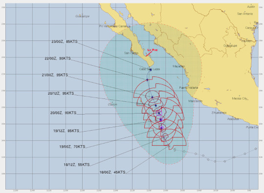
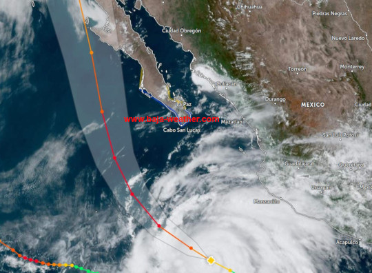
At 09:00hr MDT the tropical storm was about 395km (245mi) S of Cabo San Lucas. Norma is forecast to be a hurricane when it moves near or over the southern portion of Baja California Sur. A hurricane warning is in effect for Baja California Sur from Todos Santos to Los Barriles. The government of Mexico has extended the Tropical Storm Warning from Los Barriles to La Paz northward to San Evaristo along the east coast of the Baja California peninsula. On the forecast track, Norma is expected to approach the southern portion of Baja California Sur tonight and move near or over the area on Saturday.
Join our Baja Weather Channel here and receive instant updates if severe weather conditions at BCS occur.
1 note
·
View note
Text

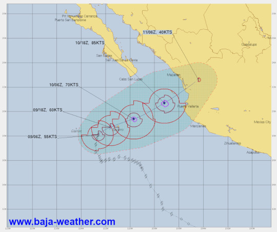
Tropical storm Norma continues to strengthen and is about 990km (615mi) SSE of Cabo San Lucas. Steady to rapid strengthening is forecast, and Norma is likely to become a hurricane later today. We keep an eye on that storm for you. At current path and speed Norma will be here about Sunday! Join our Baja Weather Channel for instant updates. At the southern part of BCS and La Paz sunny intervals during the morning, with average temperatures around 31°C. This afternoon we can expect sunny intervals and temperatures of around 35°C. Winds from the North today with an average speed of 12 km/h.
Sunrise in a few minutes at 06:20hr, sunset at 17:52hr
Join the Baja Weather Channel here
0 notes
Text
Norma is strengthening - about 1045km (650 mi) SSE of Cabo San Lucas, Mexico. At 21:00hr MDT (03:00hr UTC), the center of Tropical Storm Norma was located near latitude 13.7 North, longitude 107.8 West. Norma is moving toward the northwest near 8 mph (13 km/h), and a northwestward to north-northwestward motion at a slightly slower forward speed is expected during the next several days. Maximum sustained winds have increased to near 85km/h (50 mph (85) with higher gusts. Steady to rapid strengthening is forecast, and Norma is likely to become a hurricane on Wednesday.
Tropical-storm-force winds extend outward up to 220km (140 miles) from the center.
Join our Baja Weather Channel here
0 notes
Text

With rising temperatures the coming days again today at southern Baja peninsula incl. La Paz clear skies during the morning, with average temperatures around 30°C. This afternoon we can expect clear skies and temperatures of around 34°C. Winds from the North today with an average speed of 11 km/h. Sunrise in about 1 hour at 06:19hr, Sunset at 17:54hr In LP first high tide at 10:02hr, second low tide at 16:58hr, second high tide at 23:06hr.
Join our Baja Weather Channel here...
0 notes
Text
Good morning Baja Sur! Have agreat start into the week! We will start the week with cloudy skies during the morning, average temperatures around 29°C. This afternoon we can expect sunny intervals with light rain and temperatures of around 30°C. Winds from the Northeast today with 9 km/h. - Lidia turning northeastward, hurricane conditions forecast to begin on Tuesday 550 km (340mi) SSW of the southern tip of Baja California. We will experience some impact from the outskirts of the hurricane if it continues at the current trajectory. (Tropical-storm-force winds extend outward up to 165km (105 miles) from the center. Interests in the southern portion of the Baja California peninsula should monitor the progress of Lidia.
Join the Baja Weather Channel here....
0 notes
Text

Good morning Pacenas y Pacenos! It is a beautiful morning here next the Parroquia Espíritu Santo in the Puesta del Sol area of La Paz pre sunrise at 05:30hr. Perfect time for morning jogging! Our Ambient weather-station clear skies during the morning, with average temperatures around 34°C. This afternoon we can expect clear skies & temperatures of around 37°C. Winds from the North today with an average speed of 14 km/h. Join our Baja Weather Channel >>>>>>
Baja Weather-Channel
0 notes
Text

Good morning pacenas and pacenos - here is our 3-day outlook for the weekend. For today here in greater La Paz area we will observe overcast skies with light rain during the morning, with average temperatures around 28°C. This afternoon we can expect cloudy skies with light rain and temperatures of around 31°C. During the night there will be eventually some light rain with an average temperature of 28°C. Winds from the Southwest today with an average speed of 10 km/h. The sun will rise at 06:02hr and sunset will be at 18:39hr The predicted tide times today on Friday 01 September 2023 for La Paz are: first low tide at 05:05hr, first high tide at 11:16hr, second low tide at 16:59hr, second high tide at 22:56.
Join our Baja Weather Channel here and get updates on current weather related event in Baja California Sur as well, most the time one, if not 2 photos including our in meantime famous "Palm-o-Meter" (pic taken by a contributor at La Paz's Puesta del Sol area next to Convento Madres Adoratrices and Capilla San Charbel including a palmtree which serves as wind benchmark)
0 notes
Text

Today in La Paz sunny intervals during the morning, with average temperatures around 31°C. This afternoon partly cloudy with afternoon showers or thunderstorms. High 34°C. Winds WSW at 10 to 15 km/h. Chance of rain 80%.
Join the Baja Weather Channel here...
1 note
·
View note
Text

Good morning Pacenos and Pacenas - stifling humidity is forcast for the coming few hours and indeed we can confirm that at 05:30hr at Puesta de Sol area next to the Convento Madres Adoratrices compound. Otherwise today for La Paz we rxpact clear skies during the morning - check out our Cerro Atravesado shot just taken, with average temperatures around 33°C. This afternoon we can expect sunny intervals and temperatures of around 38°C.
So we like to repeat outrselfes: Avoid direct impact of sunshine and stay hydrated. The UV index will be very high today with 11 expected of a scale 1-12. The UV Index is a forecast of the probable intensity of skin damaging ultraviolet radiation reaching the surface during the solar noon hour. The greater the UV Index, the greater the amount of skin damaging UV radiation. The threshold for skin damage is dependent on several factors, including skin tone.
Note that clouds do not block most UV light. Winds from the North today with an average speed of 13 km/h. Sunrise is at 06:00hr, sunset at 18:36hr
Join our Baja Weather Channel here....
0 notes
Text

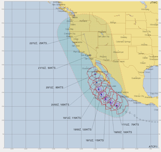
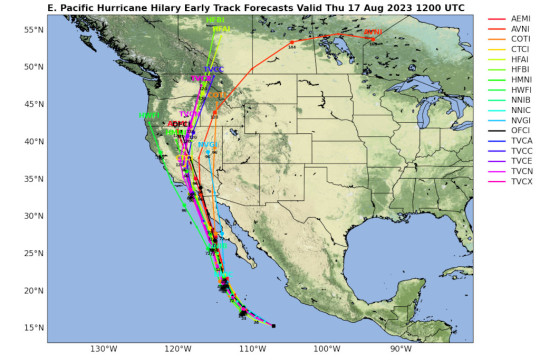
Hilary remains a powerful category 4 hurricane. Life-threatening and potentially catastrophic flooding likely over much of Baja California peninsula and southern California this weekend and early next week! The government of Mexico has upgraded the Hurricane Watch to a Hurricane Warning on the west coast of Baja California northward to Cabo San Quintin and upgraded the Tropical Storm Watch to a Tropical Storm Warning north of Loreto on the east coast of Baja California and north of Guaymas in mainland Mexico. A Hurricane Warning means that hurricane conditions are expected somewhere within the warning area. A warning is typically issued 36 hours before the anticipated first occurrence of tropical-storm-force winds, conditions that make outside preparations difficult or dangerous. Preparations to protect life and property should be rushed to completion.
A Hurricane Watch means that hurricane conditions are possible within the watch area. A watch is typically issued 48 hours before the anticipated first occurrence of tropical-storm-force winds, conditions that make outside preparations difficult or dangerous. Interests at the southern Baja California peninsula should definitely monitor the progress of Hilary!
At 15:00hr MDT (2100 UTC), the center of Hurricane Hilary was about 125 km (80 mi) W of Socorro Island, a volcanic island in the Mexican Revillagigedo Archipelago and about 525km (325 mi) SSW of Cabo San Lucas, Mexico with maximum sustained winds of 215 km/h (130 mph) Hilary is moving toward the northwest near 19km/h (12 mph). A turn toward the north-northwest is expected tonight, followed by a faster motion toward the north Saturday night and Sunday.

On the forecast track, the center of Hilary will move close to the west coast of the Baja California peninsula over the weekend and reach southern California by Sunday night.
Join the Baja Weather Channel here...
0 notes
Text
Hilary continues strengthening rapidly likely to become a major hurricane later today. At 09:00hr MDT (15:00hr UTC), the center of Hurricane Hilary was located about 590km (365 mi) SSW of Cabo Corrientes, Mexico and about 850km (530 mi) SSE of Cabo San Lucas, Mexico. The government of Mexico has issued a Tropical Storm Warning for the southern portion of Baja California Sur peninsula from Cabo San Lazaro southward on the west coast and Los Barriles southward on the east coast.
Hilary is moving toward the west-northwest near 14 mph (22 km/h), and this general motion is expected to continue through tonight.
A turn toward the northwest is expected Friday morning, followed by a turn toward the north-northwest and north on Saturday. On the forecast track, the center of Hilary will approach the Baja California peninsula over the weekend. Interests elsewhere on the Baja California peninsula and along the coast of northwestern mainland Mexico should closely monitor the progress of Hilary. Large swells generated by Hilary will affect portions of the coast of southwestern Mexico and the Baja California peninsula over the next few days.
Join our Baja Weather Channel here....
0 notes
Text

The full moon on 1st. of August is the second of four supermoons in the summer of 2023, with the next, the Full Blue Moon, falling on 30th August 2023. August is an exciting month for moon lovers, with the summer month opening and closing with a supermoon. The Full Sturgeon Moon rises on Tuesday, 1st of August and then the month closes out with the Full Blue Moon. Much like the Strawberry Moon or the Pink Moon, the Sturgeon Full Moon draws its name from similar inspiration. These names come from happening or landscapes in the Northern Hemisphere. According to The Old Farmer's Almanac.
Following the Sturgeon full moon, the illuminated lunar face will recede with the moon being described as "waning." The waning moon will also rise and set an hour later each day. This leads to the next new moon on Wednesday, 16. August 2023.
So-called supermoons occur because the orbit of the moon around the Earth is not a perfect circle but is instead a flattened circle or an ellipse.
This means that during its 27.3-day orbit, there are points at which the moon is closer to the Earth and points at which it is further away. The visible size difference of the moon between the closest point, perigee, and the furthest, apogee, is about 14%.
Join the Baja Weather Channel here...
6 notes
·
View notes