27 😊PNW 🌲Weightloss Blogger 💻Certified Mixxedfit Instructor 🙅🏽Do daily workout check-ins 😅I've lost -157 lbs and still going 🙇🏽Friends, family, food and fitness #FFF
Don't wanna be here? Send us removal request.
Statistics
We looked inside some of the posts by find-greatness and here's what we found interesting.
Average Info
Notes Per Post
958K
Likes Per Post
407K
Reblog Per Post
551K
Reply Per Post
33
Time Between Posts
5 days
Number of Posts By Type
Photo
10
Text
5
Video
2
Last Seen Tumblr Blogs


Fun Fact
Tumblr has 411 employees.
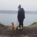
Photo


52 Hike Challenge ✌🏽 6/52
22 notes
·
View notes


Text
Rosamond Cross | Trip Report | 1.29.16
*Scroll down for trail report or read this long post about the best grandparents in the world*
California holds such a special place in my heart. It's where most of my family is from and where I was born. I only lived in California until I was about six. My parents always talk about when we moved to Washington that I refused to wear pants because I'm a girl meant to be in sundresses and back then skorts! Summer is still my favorite season!
Since moving to Washington I've only been back to California a handful of times but favorite time was the summer of 2004. Our house at the time was currently full with people, we had a dog that was about to have puppies, it was summer break and I was bored teenager and was losing my mind. Not sure if I begged my parents or my grandparents but I was able to get out of my house and spend the entire summer with my grandparents.
Now everyday wasn't a vacation in fact I spent the summer at my grandmas Hair Store but it was the first time I got to really get to know my grandparents. That summer I got to watch my grandma run a business from the inside and out. My grandma was equal parts stern and loving which made her the BEST boss ever. I also got to spend time with my grandpa! I really think I get some of my habit skills from him. This guy would work night shifts as a janitor, go swimming at the gym, then follow that up with some hearty McDonald's with friends and then come home before we left for work. I also get to be subject to endless stories about growing up in South Dakota and walking thru the snow to school in shoes with holes in it. Together we spent a lot of time at home or at their favorite place, Home Town Buffet talking and really enjoying each other’s company.
My grandparents were truly the kindest people in the world! To open up their home and put up with my sassy teenager self is a testament to them. They made a impact on my life that summer and I will forever cherish those memories. Soon enough (not any time soon) I'll be able to share my story about that summer with my kid or future grand kids.
Date: January 29, 2018 Miles: 2.16 miles RT Elevation: 510 ft. Highest Point: 2561 ft. Parking Pass: None Location: Rosamand, CA
I had big plans to go to where they filmed the Flintstones but I didn't have much time and this place was conveniently located right behind my aunts house! Now I should say this isn't a hike or at least one that comes up AllTrails or Google so all the info above is based on my fitbit. I did this hike 3 days in a row. The first two days were short and sweet and the 3rd day I got some exploring mileage in and that's the route i'm counting.
Day 1 | January 27th |
Now the first day I did this hike to the cross I went from the front. The path to the cross that goes directly up is about 500 ft of elevation of gain in 1/4 of a mile! It's pretty freaking difficult and it's all dirt and rocks. I share the photo of my dad because even though it was hard and he to take a break halfway up, he finished and made it to the top.
Day 2 | January 28th |
I had all intentions of making this my long hike day but I didn't get much sleep and was planning on driving to LA with my dad and brother. This time on the trail I went up another way my aunt told me about. It wasn't much different then the direct route but it was a little less steep. It was a calming early morning and it was this day that I starting falling in love with desert landscape.
Day 3 | January 29th
This was the day of my grandpas service so I needed the trail to give me all the energy for the day and it delivered. This is the day i'm counting as #4 of the 52 Hike Challenge as it was the longest. From the previous two days I had a route I wanted to tackle which took me around the base of the cross and up the opposite side. This side took me up close and personal with the rock formations that I was eyeing!
The desert of Southern California is so drastically different then where I hike but I found so much beauty in it. The gold color of the dirt, the random colorful succulents and plants, endless views of the desert landscape, and the mysterious rock formations make hiking in California an amazing adventure. It was also a first that I didn't have a map or some sort of guide. I know it was only two miles but being on this hill every day and choosing my own adventure was something that I've never gotten to do before.
4 notes
·
View notes
Text
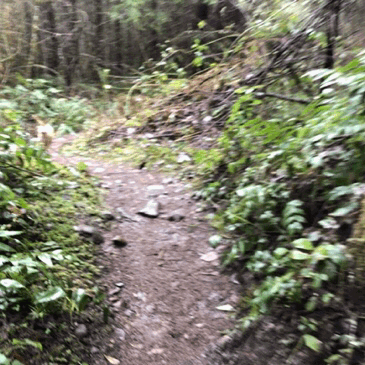
Oyster Dome | Trip Report | 1.20.18
Oyster Dome is a hike that everyone talked about when I went to Western. When I went to Western I was 100 lbs heavier and felt at the time that I was in no shape to go hiking. I didn't have Unlikely Hikers or Fat Girls Hiking and other great feeds with bodies like mine hiking. I say that all to say I've wanted to this hike for a long time because even though I didn't feel in shape for hiking back then I was sorta jealous of everyone else who went when I was in college.
This hike was more then just conquering a hike that's been on my bucket list for years it was also the anniversary of my brothers death. January 20th of 2017 my brother passed away after 3 years of fighting with his body. I knew I wanted to hike because it makes me feel closest to him and It just so happened that one of my best friends recently moved back to Bellingham and had a spare bedroom. So I headed that direction early Saturday morning, solo!
Date: January 20, 2018 Miles: 5 miles RT Elevation: 1050 ft. Highest Point: 2025 ft. Parking Pass: Discovery Pass Location: Bow, WA
The first directions took me to Chuckanut Drive which technically is the start of the Oyster Dome Trail but it requires you to park on the highway. I didn't see anywhere to park or the trail head so I re-read the WTA report and took Google Map directions from there. That ended up taking me north on Chuckanut Drive and back to the freeway. I continued to take those directions and 30 minutes later I ended up in the middle of Bow and I realized I did complete circle. After pulling over to the side I read the entire WTA reports and took the directions to Samish Overlook.
When I finally made it to the parking lot it had maybe 5 cars in at 8:45 am. The view (pictured above) when you pull up is amazing! If you ever find yourself just going for a drive and don't want to hike this is a great view. This lot requires a Discover Pass but there is plenty of reception if you need to buy a day pass over the phone.
I started the trail at 9:00 am. Not even a solid 10 minutes in I came to the down tree that was in the WTA reports. When I read the reports everyone made it seem like a log you could jump over but it wasn't. It took me like 5 minutes to figure out how I could get over it and I ended up following foot prints up and around. The soil is really loose and when I thought I was in the clear it gave out below me and I ended up getting my pants stuck on a branch and ripped my pants. Thankfully it only went thru my first layer but I ended up with ripped pants and dirt all over me.
After that obstacle I continued on the trail. Thinking back to my college days I had it in my head that this hike was going to be a challenge but It was actually pretty easy. I worked up a sweat but overall the trail didn't have to much gain, there was signage so you couldn't get lost and it was well maintained. It's crazy how we hype things up in our head! The trail has a few creek crossing which I'm guessing could get a little hard to cross but It wasn't bad with boots. I wouldn't recommend sneakers for this hike. The hike is beautiful and for for the first 1.5 miles I didn't see a single person so I really got to take it all in.
It took me a little over an hour to get to the top. I knew while hiking up I wasn't going to get a view...and I was right. Came out to the clearing and I couldn't see further then the edge of the rocks. It ended up just making me laugh! This entire hike I felt so close to my brother by the time I got to the top I just felt like he brought the clouds to play a joke one me like when we were kids.
I spent some time at the top hoping for a break in the clouds but after 20 minutes I gave up and started heading down. I took my sweet ass time coming down from this hike. I always love hiking alone because I can walk as slow or as fast as I want. The trail was picking up the closer I got to the parking lot. There was a break in the clouds on the way down so i'm jealous that people probably got the view that I didn't.
Overall this hike was just what I needed. I felt so close to my brother and so much better about how I am doing mentally. It's been hard to think of my brother and not cry in the last few months. However this hike was the first time I thought about our favorite memories together and smiled. I miss my brother so much but I wrote about this on Instagram, but I felt like he was right by my side the entire day!
6 notes
·
View notes
Text
Favorite Hikes of 2017
At the beginning of 2017 I didn’t set out to almost triple the amount of hikes I’ve done in my lifetime combined but I did. I completed 24 hikes! That’s not including all the hikes I did at my favorite city parks; Swan Creek Park, Point Defiance and Chambers Bay Loop. 2017 was the year I lost my brother, grandma and on the first day of 2018 I lost my grandpa. 2017 sucked! I fell into depression, suffered from grief, had my first anxiety attack and on top of everything I have to live in Trumps America. The trail served as healing space for me and way to continue to move my body even when I didn’t want to get out of bed. As we move into 2018 I’m confident it will be a better year and if I learned anything from 2017 that means a lot of hours on the trail. But to sum up 2017 here are my favorite hikes!
SUMMIT LAKE Date: July 2, 2017 Miles: 6.1 miles RT Elevation: 1300 ft Highest Point: 5800 ft. Parking Pass: Northwest Forest Pass
The view! The view! The View! This hike had the best view of the entire season. The trail was well marked until we hit snow. We got a little lost but since it’s a popular spot tracks were easy enough to spot. Having lunch Cliff side and staring at Mount Rainier in all its glory will forever be one of my favorite memories. Only downside of this hike was the 7 mile forest road that you definitely need high clearance car to navigate.
BOUNDARY TRAIL Date: July 9, 2017 Miles: 4.2 miles RT Elevation: 702 ft Highest Point: ----- Parking Pass: Northwest Forest Pass
After WEEKS of seeing wildflowers at Mt. St Helen's I knew I needed to go. I've only been once before and it was actually in fall of 2016 with both of my parents. We didn't hike just drove to opposite side of the mountain on a semi gloomy day. Going back in July was a totally different experience. First of all we drove up as the sun was rising and it was nothing but clear sky's. Love having a dad as crazy as me that's down to get up early on a Saturday to hike. When we got to Johnston Ridge Observatory we were one of the few cars in the lot.
As soon as you park you see the flowers everywhere. Something about flowers blooming after a tragedy felt so special and served as reminder to keep trying to bloom no matter what life throws at you. The trail was easy to follow and I wish we could have done the whole thing but my dad and I didn't pack for the conditions. By the time we left at 10 am it was almost 70 and between the two of us we only had 2 bottles of water and a couple cliff bars. I'm excited to come back a couple times this year. Especially because I plan to summit Mt. St Helen's THIS SUMMER.
MOUNT ELINOR Date: July 30, 2017 Miles: 6.2 miles RT Elevation: 3300 ft Highest Point: 5944 ft Parking Pass: Northwest Forest Pass
Mount Ellinor took close to 9 hours, I fell multiple times and wanted to give up more then ever but it was worth completing. We took it from the lower trail head and up until the trail meets up with Upper trail head the hike is a gentle hike and after it's a fucking climb! 2,444 feet of elevation in 1.6 miles?! If you know nothing about hiking this sucks 10/10 don't recommend if you've never hiked before. The trail itself was super easy to follow minus the snow left over from winter but there were enough people on the trail to lead the way. We got to the top and the cloud coverage broke enough to get some awesome views of the Olympics and even Mt. Rainier came out for awhile in the distance. Like I said it was hard as hell but if I had to rank my favorite hikes in order this was #1! Shout out to the best hiking partner in the world for not giving up on me because I was not friendly about pushing myself to the limits.
KENDALL KATWALK Date: September 23, 2017 Miles: 12 miles RT Elevation: 2600 ft Highest Point: 5400 ft Parking Pass: Northwest Forest Pass
Shout out to my therapist for telling me when I have a bad day/week I need to go for a hike. That's why after a horrible week and lack of sleep I returned to solo hike Kendall Katwalk. I got to the trail head an hour before it was light but I just laid in the car until there was enough sunlight to get started. I've done this trail before it's part of the PCT, easy to follow and the views are amazing the entire way to the Katwalk. The picture above is taken at my favorite place on any trail, ever. At this spot you turn the corner and it becomes completely silent! It's a crazy sensation and I hiked to this spot and spent some time reflecting. The next day I wrote a very personal post (link to post) about my struggle with grief and depression that I wouldn't be able to write without getting out that day.
6 notes
·
View notes
Text
Little Si | Trip Report | 1.2.18
First hike of 2018 and more needed then I ever thought it would be. January 1st in the early morning my grandpa passed away. I spent that entire day in bed unable to function. As this is one of my first blog posts of 2018 you should know in January of 2017 I lost my brother after two years of him being really sick. Then in June I lost my grandma very suddenly. To say I had a tough year is an understatement. I plan to write more about dealing with the grief on the trail later but that’s a little back story of why I hiked on a Tuesday.
Date: January 1, 2018 Miles: 4.7 miles RT Elevation: 1300 ft. Highest Point: 1550 ft. Parking Pass : Discover Pass Location: North Bend, WA
This was one of the first hikes I did in 2017 and the perfect cloudy day hike. I pulled up to the trail a little after 11 am being a popular hike even on a Tuesday there were about 20 cars in the parking lot. This hike requires a Discovery Pass but there is reception at the trail head for you to buy a day pass if you need to. I layered up for this hike but the beginning of this hike starts with a climb and those layers quickly came off. It was 45 degrees and windy but I hiked most of this hike in just a long sleeve shirt and capri leggings. This hike is ridiculously easy to follow and it’s beautiful. You get a little bit of everything; Mossy trees, hundreds of ferns, boulders, some cliff sides and at the end views. About halfway up I stood still in the middle of trail, took out my headphones, closed my eyes and just listened to the wind as it blew the trees and ferns.
When I do hike solo I do listen to something and because of the emotional state i was in I re-listened to Rising Strong by Brene Brown. 10/10 recommend this book! Brene Brown reads it herself and her voice is fitting for some reason when hiking. It took me about an hour to get to the top. I spent a solid 30-40 minutes exploring different parts of it. There are plenty of places if it was a busier day to find some solitude. Even on a cloudy day you get views of the valley, Big Si and other peaks in the area. The descent went fast as I had spent a lot of time much time at the top and needed to beat the evening traffic. This hike is perfect for beginners, trail runners and anyone just wanting to get a quick view that doesn’t (at this time) require any extra gear and can be done in sneakers.
5 notes
·
View notes
Text
Margaret's Way | Trip Report | 1.7.18
It's official I'm doing the #52HikeChallenge in 2018. I was iffy about it for a long time but after today's hike the trail was telling me to do it! I'm all in! I plan to balance it with solo hikes, city trails and going out of my comfort zone and hiking with new people. If you're reading this and looking for a person to hike with I'M YOUR GIRL. I'm on the slower side, complain about being sweaty, have a dog who will get you muddy, I talk about pop-culture, politics is my favorite topic and I hate snow but If that doesn't bother you then I'm your girl! Hit me up if you want to plan a weekend.
Date: January 7, 2018 Miles: 6.9 miles RT Elevation: 1500 ft. Highest Point: 1730 ft. Parking Pass: None Location: Issaquah, WA
This was my first time on Squak Mountain and first time hiking with my new friend, Kelsey. Issaquah is about a 50 minute drive from Tacoma and the entire drive it was raining pretty hard. I got to the parking lot at 8 am after making a wrong turn. When I pulled up there was only 4 cars in the lot. It's a King County Park so you don't need a parking pass and there is a Porta Potty in the parking lot.
We started the trail around 8:30 ish. After a little confusion we made it to the official trail head and after that this hike was so well marked unlike it's neighbor, Tiger Mountain. I don't have the best since of direction so it was greatly appreciated. The trail itself was well maintained like many King County owned trails. There were some muddy parts and some trees that sound that a strong gust of wind could knock over but overall a great trail for an overcast day.
The rain pretty much stopped 20 minutes into our hike which made for such a better experience. The first mile or so was moderate but there was some heavy breathing and work needed to get your ass up. There was a point in the first mile or so we saw a little bit of view and were relieved that we would have view of some kind. The first viewpoint was called Margret's View and it was beautiful. Spent some time there re-fueling and taking pictures. Whoever lives next to to the view point is very lucky. I could only imagine what it's like on clear day.
After that we moved into the dense forest to get to our final destination Debbie's View. The colors were so vibrant, lush and we spent sometime just in awe of it all. The trail winds up slowly for awhile until you get to the final push of I'm thinking a dozen switch backs. Again, heavy breathing was happening but not so much that I couldn't keep a conversation. Debbie's View was worth all the effort. We had views and the sun came out over the mountains and we were up there for about 10 minutes before another group joined us. Again, I could only imagine what this looks on a clear day.
With all the detours of view points we did about 6.9 miles according to Kelsey's All Trails App. Which considering my Fitbit said 8+ miles I'm positive 6.9 sound about right. We were not the only people question the 5.5 miles shown on the WTA website. This was a moderate hike and considering it's so close Seattle it's accessible and easy to get to for most. We only saw about 15 people and considering you could see double that amount on Tiger Mountain trails this is great alternative.
Further Information and details: http://www.wta.org/go-hiking/hikes/margarets-way https://www.seattletimes.com/life/travel/margarets-way-hike-is-new-option-for-winter-wanders-in-issaquah-alps/ https://www.alltrails.com/trail/us/washington/margarets-way-trail
4 notes
·
View notes
Photo

I feel like I share this photo every year but I love it and all our old photos are in storage. HAPPY HAPPY BIRTHDAY TO MY LITTLE BRO @j_chillhouse You’re old, kinda cool and have a boring snap story. But I love you so much! Have a great day ♥️♥️♥️ #28 #birthday #happybirthday #brother #loveyou
1 note
·
View note
Photo

At some point in life, the worlds beauty becomes enough - Toni Morrison #life #explore #outdoors #optoutside #pnw #monday (at Upper Twin Falls)
7 notes
·
View notes
Video
instagram
Happy place 🤗 #hike #dayhike #river #dancing #boomerang (at Upper Twin Falls)
6 notes
·
View notes
Photo
“It’s a place to cultivate warm energy and comfort” shout out @aubreyisie for saying that and inspiring me to turn my spare bedroom into a woman cave. I’ll share pictures of the room when it’s more then a chair that took 30 minutes to fit in the door and a yoga mat. 📖🧘🏽♀️ #womancave #yogaspace #readingnook #mentalhealth #health #life #home
4 notes
·
View notes
Photo

“It’s a place to cultivate warm energy and comfort” shout out @aubreyisie for saying that and inspiring me to turn my spare bedroom into a woman cave. I’ll share pictures of the room when it’s more then a chair that took 30 minutes to fit in the door and a yoga mat. 📖🧘🏽♀️ #womancave #yogaspace #readingnook #mentalhealth #health #life #home
0 notes
Photo

How did I get so lucky. My pup is the best ♥️♥️ #happyplace #mydog #sleepydog #cutie #ohspetsarethebestpets #ohs #adoptdontshop #ratcha #muttsofinstagram
5 notes
·
View notes
Photo

Don’t forget to thank yourself. ♥️ #happythanksgiving #hike #hiking #life #happyhiking #optoutside #pnw (at Fall Creek Falls)
2 notes
·
View notes