my personal master thesis blogexplore ideas, inspiration and career snapshots
Don't wanna be here? Send us removal request.
Statistics
We looked inside some of the posts by leonnelsonbellina and here's what we found interesting.
Average Info
Notes Per Post
435
Likes Per Post
279
Reblog Per Post
156
Reply Per Post
0
Time Between Posts
19 hours
Number of Posts By Type
Text
9
Photo
6
Last Seen Tumblr Blogs


Fun Fact
Tumblr was named as a finalist in Lead411’s New York City Hot 125 in Aug 2010.
Text
Hello and welcome! ☀️🌲
This is my very personal blog about my inspirations and thoughts that I would love to research on for my master thesis. You can also find some career snapshots and experiences I have gained at university and work. Feel free to scroll through the posts I have created or reposted! Wishing you an amazing and sunny day. Kind regards, Leon Nelson Bellina
0 notes
Text
The Inspiration for my Master Thesis Application
In 2022, my partner and I took a trip to New York and instantly fell in love with the big city. One day, when we visited Hudson Yards, we came across a public park called the 'High Line' that I had not heard of before. A beautiful park built on a historic freight rail line, elevated above the streets of Manhattan's West Side, it stretches out for about 2.33 kilometers, connecting the Meatpacking District with Hudson Yards.


As someone whose interests lie in traffic, urban planning, ecology, architecture, and design, I was blown away. The concept of reusing abandoned infrastructure to turn it into green spaces for the public offers great potential for future projects, especially in dense urban areas. I was also impressed by the fact that this project supports local biodiversity by providing habitat, pollinator, and food sources for a diverse array of plant species, birds, and other wildlife. In addition, the park also incorporates sustainable design features by including permeable paving and rain gardens to manage stormwater runoff and counteract the urban heat island effect. Pedestrians are also provided with a completely new way of sustainable commuting through the city. As an elevated and dedicated pathway for walking away from motorized individual transport, the High Line improves safety and accessibility.


These aspects, and many more, continue to bring me back to this urban development and our trip to New York City. Therefore, I would love to have the chance to dedicate my master's thesis to writing about topics related to urban redevelopment projects like the High Line. I could imagine myself investigating the additional services and benefits that similar approaches provide to public spaces, cities, and the people. Is there a way to recreate these processes with other abandoned infrastructure? Is there an opportunity to apply similar projects to cities in Europe, especially Germany? If so, what needs to be done differently? What would be the requirements? How could these parks be designed, and how would they look? The list of questions is extensive. In conclusion, exploring this project presents an intriguing and valuable opportunity for further research in the context of my master's thesis, and it's a topic that I would be passionate to work on.


1 note
·
View note
Text
My Bachelor Studies
In my Bachelor's studies, I developed a broad technical and planning knowledge in the field of geoinformatics and municipal engineering. The diverse curriculum included topics such as urban and regional planning, which involved the application of GIS data in planning decisions. Other important focuses of the program were project management, construction and land law, as well as environmental technology. This encompassed the planning, implementation, and evaluation of projects with a focus on environmental monitoring and management. Another key area was GIS, cartography, and surveying. Here, I acquired skills such as data capture, analysis, and visualization, which are relevant for site analysis and design development. In municipal engineering, the focus was on infrastructures such as transportation systems, waste management, water supply and disposal, as well as energy supply.
My Courses
Bachelor-Thesis: Integration of open traffic data from Open Street Map into local geographic information systems
Study Project: IM - Road Monotoring and Assessment
Mandatory elective modules: Traffic Management and Computer Aided Facility Management (CAFM)
Technical Infrastructure - Water / Waste, Transport and Energy
Land Use Planning - I and II
Geoinformation - I, II, Specialisation and 3D
Facility Management - I, II and III
Mathematics for Engineers - I and II
Surveying - Surveying, Spatial Reference, Remote Sensing and Satellite Surveying
Informatic
Statistics Financial Mathematics
Law
Administration
Structural Engineering
English for Geomatics
Project Management
Management
Interdisciplinary General Studies
Real Estate Assessment
0 notes
Text
My Master Studies
By opting for a Master's program in Urban Ecology following my Bachelor's degree with a technical focus, my intention was to broaden my expertise in environmental conservation and sustainability. Developing intelligent and sustainable concepts for urban living spaces was one of many focal points. Also included were methodological competencies and expertise in addressing planning, technical, and environmental challenges in urban environments. Knowledge of ecosystems and their significance for humanity and society, mastery of scientific and planning methods, and the ability to independently develop solutions for practical and scientific problems were skills I acquired during my master's studies.
My courses
Environmental Resources in Urban Regions
Introduction to Urban Ecosystem Sciences
Green Spaces Management and Development
Geo Information Systems
Natural Hazards: Processes and Risk Management
Making Green - the Sustainability of Consumer Products
Student Research Project - X-Tutorial
Computer-Aided Methods in Environmental Research
Urban Soils
Inland Water Ecology B
Meteorology and Climatology for Environmental Sciences
0 notes
Text
My Relevant Professional Experiences
2022-2024: Working Student as a Traffic Planner at LK Argus and Ramboll Deutschland GmbH
• Geospatial data analysis for evaluating and visualizing traffic concepts • Assistance in projects related to traffic calming, noise action planning, parking analysis, pedestrian and cycling planning at the municipal, urban, and neighborhood levels • Research activities on guidelines, laws, technical solutions, etc. • And many more
in 2020: Research Assistant at the Research Lab for Urban Transport (Frankfurt University of Applied Sciences)
• Area classification of the survey area Hanau in GIS • GIS visualization of parking space data • GIS visualization of traffic networks
0 notes
Text
My Skillset
Through my studies and diverse experiences in project work as a traffic planner, I have deepened my interest in and knowledge of sustainable urban planning. In doing so, I have learned the importance of understanding traffic flows and their impacts on the environment.
The aesthetic and functional design of public spaces through the skillful arrangement and structuring of street spaces is equally significant to me. I see this as an opportunity to not only make urban spaces efficient but also aesthetically pleasing, thus enhancing the well-being of people.
The integration of sustainable planning practices is central to my work. I have already worked on projects such as creating noise action plans, traffic calming, and promoting pedestrian and bicycle traffic at the municipal, urban, and neighborhood levels, gaining valuable experience in the process.
My communication skills with planning teams, government authorities, and other stakeholders have been further developed through my project work.
Flexibility and creativity are also vital components of my work as a traffic planner. I am open to new ideas and approaches, viewing challenges as opportunities to develop innovative solutions.
A solid technical understanding is essential to me. Through my studies and professional experience, I have deepened my skills in working with Geographic Information Systems, particularly with products like ArcGIS from Esri and QGIS, as well as with PostgreSQL. Additionally, I have gained initial experience with GIS on a three-dimensional scale as well as AutoCAD and Building Information Modeling (BIM), complementing my technical profile.
0 notes
Text
Similar Projects and Approaches
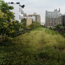
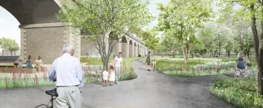
"Parkbogen Ost" - City Leipzig
A section of the eastern railway arch in Leipzig was decommissioned by Deutsche Bahn. The "Parkbogen", especially the Sellerhäuser Bogen area, is now evolving into a promenade, fostering equal access for all mobility groups and shaping a new public space. Upon completion, the Sellerhäuser Bogen park will add around 70,000 square meters of green spaces, biotopes, paths, recreational areas, and inclusive sports and play facilities to Leipzig's eastern district.

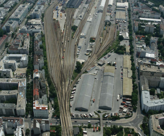
"Städtebauliches Leitbild Nordwestbahnhof" City Vienna
The Nordwestbahnhof was a former freight railway station that is no longer in operation, thus offering potential for new urban developments. Vienna's urban development plan aims to transform abandoned areas into a dynamic, sustainable neighborhood by embracing innovative approaches to living, transportation, and green spaces. With a focus on inclusivity and functionality, the project integrates diverse uses, revitalizing neglected spaces for a vibrant urban environment.

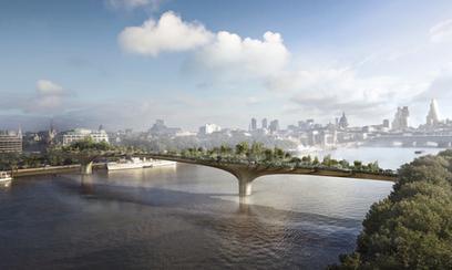
"The Garden Bridge" - City London
The London Garden Bridge was proposed as a unique pedestrian bridge adorned with extensive greenery including trees, flower beds, and shrubs. Despite initial support, the project faced controversy over its cost, funding, and environmental impact, leading to its eventual cancellation in 2017.
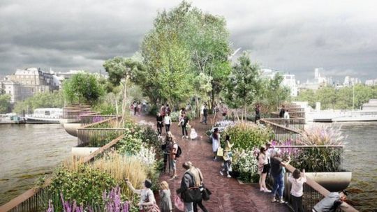
"High Line Park Vienna" - City Vienna
Based on the concept of the High Line in New York, a High Line Park is planned to be developed along the decommissioned route of the U6 subway line in Vienna. From the 800-meter-long disused subway line route, a green recreational area is planned to be created.


0 notes
Text
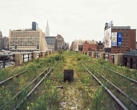
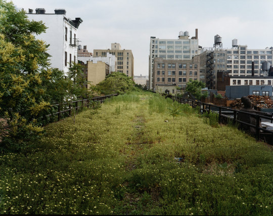
Walking the High Line
Joel Sternfeld New York, 2000
56 notes
·
View notes
Text
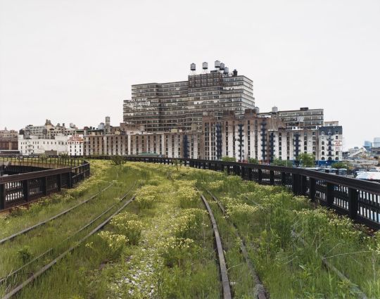
Joel Sternfeld. View of The High Line abandoned elevated railway with the Starrett-Lehigh Building, New York City, New York, United States, May 2000.
364 notes
·
View notes
Photo

THE PARALLEL PARK: Comprehensive Landscape Development Plan - Revitalization of MRTS - IT Corridor, Chennai, India #chennai #urbanlandscape #urbandesign #urbanpark #urbanplaza #landscapedesign #landscapearchitecture #India (at Adyar, Indira Nagar) https://www.instagram.com/p/B1QucnanRn-/?igshid=NGJjMDIxMWI=
2 notes
·
View notes
Photo


The transformation of Strand Aldwych from a 4 lane carriageway to a premier public space in the heart of the cultural and educational district.
1 note
·
View note
Photo


The transformation of Strand Aldwych from a 4 lane carriageway to a premier public space in the heart of the cultural and educational district.
1 note
·
View note
Photo


The transformation of Strand Aldwych from a 4 lane carriageway to a premier public space in the heart of the cultural and educational district.
2 notes
·
View notes
Photo

Follow @urbandesign.lab
Combining the inductive and deductive approaches with the project we propose for the Golden Horn, We consider Halic as ATLAS. Its approach, which combines different scales from the individual scale to the metropolitan city, The project, which is an integrating atlas with design solutions that invites users to the space, is the same.
At the same time, the whole of the Golden Horn has an important role to play in Istanbul. doing. Being a sheltered harbor in history, it hosts settlements and industry. Although its natural structure is damaged, it is used as a part of industry and infrastructure. The Golden Horn, which carries the burden of industry and settlement, reveals its potential. With the project, in mythology, the Atlas carries the Gökdome, and Istanbul’s nature in the city.
Project by: Nergis aşar Melisa Aksun Meltem Erdem Kaya Elif Serdar Yakut HSerdar Kaya DM for credits/Removal. . . . . Photoshop Masterclass (2 Days Integrated Workshop)
Session Details: • Day 1: 18th of March, 2023 | Urban Mapping • Day 2: 19th of March, 2023 | 3D Urban Visualization
🔗Registration link in the bio
Limited Seats available!
Early Bird registration ends on 12th March, 2023 . . . . #instaarch #landscapedesign #archolution #landarch #architecturestudio #landscapearchitect #landscapearchitecture #arquitectura #archisource #architects_need #archihub #urbandesign #architecturevisualization #studyarchitecture #archidaily #archiprix #landscaperendering #architecturelife #architecturestudent #arquitetapage #landscapestudent #arch_more #dezeen #landscapediagram #arch_cad #arch_grap #photoshoptutorial #archicollage #sketchup #architecturestudent (at Istanbul, Turkey) https://www.instagram.com/p/CpDTPvjPrME/?igshid=NGJjMDIxMWI=
3 notes
·
View notes
Photo
Follow @urbandesign.lab
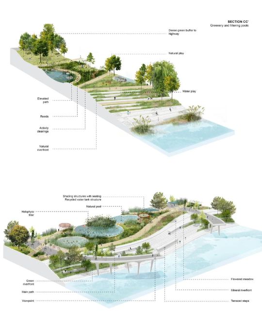
A metropolitan intervention for Seoul riverside park
A creative international collaboration between 100 Architects (Shanghai), Carve (Amsterdam) and Urien (Seoul), with the local coordination & support of the landscape architect Walter Ryu, has resulted in this proposal for a leisure facility in Seoul, South Korea.
Project by: 100architects DM for credits/Removal. . . . . Photoshop Masterclass (2 Days Integrated Workshop)
Session Details: • Day 1: 18th of March, 2023 | Urban Mapping • Day 2: 19th of March, 2023 | 3D Urban Visualization
🔗Registration link in the bio
Limited Seats are available!
Early Bird registration ends on 12th March 2023. . . . . #UrbanDesignLab #SeoulRiversidePark #MetropolitanIntervention #LandscapeArchitecture #100Architects #CarveAmsterdam #UrienSeoul #WalterRyu #InternationalCollaboration #LeisureFacility #SouthKorea #Architecture #Design #CreativeCollaboration #PhotoshopMasterclass #UrbanMapping #3DUrbanVisualization #Workshop #DesignWorkshop #LimitedSeats #EarlyBirdRegistration #DigitalDesign #Visualization #ArchitectureStudent #ArchitectureLovers #ArchitecturalRendering #ArchitecturePhotography #BuildingDesign #ArchDaily #DesignInspiration (at Seoul, Korea) https://www.instagram.com/p/CpxfXcUvQqw/?igshid=NGJjMDIxMWI=
5 notes
·
View notes