
Create professional interactive maps with our intuitive map builder. Make your own map, choose your style. Try Mapme for free.
Don't wanna be here? Send us removal request.
Statistics
We looked inside some of the posts by mapme-maps and here's what we found interesting.
Average Info
Notes Per Post
1
Likes Per Post
1
Reblog Per Post
0
Reply Per Post
0
Time Between Posts
2 months
Number of Posts By Type
Text
8
Last Seen Tumblr Blogs


Fun Fact
Tumblr’s reach among the 26-to-35-year-olds in the US is 11%.
Text
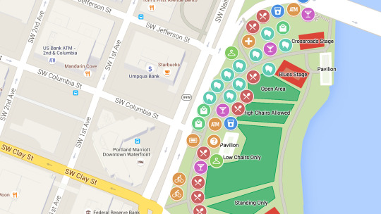
How to Use Interactive Maps for Guided Tours
Have you ever wandered through a historic city, nature trail, or museum and wished for a more immersive way to explore? Traditional paper maps or static guides can only do so much. That’s where interactive maps come in—offering an engaging and dynamic way to enhance guided tours for travelers, history buffs, and adventure seekers alike.
Whether you're organizing a walking tour, a self-guided exploration, or a heritage trail, interactive maps can transform the experience. Let’s dive into how you can create a custom map to make your tour more informative, engaging, and memorable.
What Are Interactive Maps, and Why Use Them for Tours?
Interactive maps are digital maps that allow users to engage with locations by clicking on points of interest, viewing additional details, watching embedded media, and even following guided routes. Unlike static maps, these provide a dynamic experience where users can:
Explore at their own pace – No need to rush; users can engage with locations as they go.
Access rich multimedia content – Add images, audio clips, videos, and historical facts.
Follow customized routes – Tailor itineraries for different interests and experience levels.
Navigate seamlessly – Use GPS integration to guide visitors efficiently.
Imagine walking through a historic district where each landmark on your map comes to life with a short video, archival photos, or an audio story. That’s the power of an interactive travel map.
How Do You Create a Custom Map for a Guided Tour?
Let’s break down the steps to designing a compelling interactive map for guided tours.
1. Choose the Right Mapping Tool
To create a map, you need a custom map creator that allows easy customization and sharing. Platforms like Mapme provide intuitive tools for adding points of interest, embedding media, and designing an engaging user experience.
2. Define the Tour’s Theme and Purpose
What story are you trying to tell? Are you designing a historic city walk, an art gallery tour, or a nature hike? Defining your focus helps structure the map effectively.
Examples:
Historical Tour: Mark key landmarks and add archival photos.
Food Tour: Pinpoint the best local restaurants with reviews and signature dish highlights.
Nature Trail: Highlight scenic viewpoints, rest stops, and flora/fauna descriptions.
3. Add Key Locations and Descriptions
Once your map is set up, start adding key locations. Each point should include:
A clear title (e.g., “Old Town Hall – Built in 1800”)
Engaging descriptions (Tell a story rather than listing facts)
Multimedia content (Photos, videos, and audio clips enhance the experience)
4. Design an Easy-to-Follow Route
Guided tours work best when they follow a logical path. Use waypoints and path-marking features to create a seamless flow.
Tips:
Number your locations in sequence to help users follow along.
Use color coding to differentiate stops (e.g., food spots in blue, historical sites in red).
Offer alternative routes for different interests or accessibility needs.
5. Integrate GPS and Interactive Features
A great tour map should be user-friendly and provide real-time navigation. Adding GPS integration ensures visitors can easily find their way without needing additional directions.
Interactive features to consider:
Augmented reality overlays for a futuristic experience.
Audio guides that play automatically when reaching a stop.
User-generated content where visitors can leave reviews or comments.
FAQs
Q: Can I create an interactive travel map without technical skills?
A: Yes! Many platforms like Mapme offer no-code solutions, allowing anyone to build a professional-looking map without programming knowledge.
Q: Do these maps work offline?
A: Some platforms allow offline access, but many require internet connectivity for full functionality. Consider offering downloadable PDFs as a backup.
Q: How do I share my custom map with users?
A: You can distribute your map via a shareable link, embed it on a website, or provide QR codes at tour starting points for easy access.
Q: Can businesses benefit from interactive maps for tours?
A: Absolutely! Restaurants, museums, and tourism boards can use them to promote local attractions, showcase hidden gems, and enhance visitor engagement.
Enhancing Your Tour with Mapme
If you’re looking for an easy way to build an interactive map for guided tours, Mapme is a great solution. It allows you to create a visually appealing and user-friendly experience with multimedia integration, custom routes, and GPS navigation.
Next time you’re planning a guided tour, think beyond the traditional brochure. A well-designed interactive map can make your tour more immersive, engaging, and memorable.
0 notes
Text
Top 5 Benefits of Interactive Maps in 2024
In the fast-paced digital landscape of 2024, interactive maps have emerged as indispensable tools that go beyond traditional boundaries. In this blog post, we will delve into the top five benefits of interactive maps, focusing on the prowess of map builder and their transformative impact on real estate. Along the way, we'll introduce you to Mapme, an online platform designed to make map creation a breeze.
1. Revolutionizing Map Creation with Map Builders:
The landscape of map creation has evolved significantly with the advent of sophisticated map builders. These tools, such as the user-friendly platform Mapme, empower individuals and businesses to effortlessly create stunning and dynamic interactive maps. With drag-and-drop functionalities and customizable templates, map builders are democratizing cartography, allowing users to bring their visions to life without the need for extensive technical expertise.
2. Engaging Users with Interactive Maps:
In the dynamic world of 2024, interactive maps have proven to be highly engaging across diverse industries. Whether you're planning a trip, exploring a new neighborhood, or seeking a map for real estate options, interactive maps provide a visually compelling and informative experience. Users can zoom in, click on specific points of interest, and access relevant information, making the exploration both interactive and enjoyable.
3. Real-Time Data Integration for Informed Decisions:
The demand for real-time information is paramount in 2024, and interactive maps rise to the occasion. Map builders, including Mapme, facilitate the seamless integration of up-to-the-minute data. This feature is particularly beneficial for real estate professionals, enabling them to create maps for real estate showcasing property listings with current availability and pricing. The ability to integrate real-time data enhances decision-making processes and fosters transparency between stakeholders.
4. Facilitating Collaboration through Map Creation:
Collaboration lies at the core of successful ventures, and interactive maps streamline communication among team members and stakeholders. Mapme, a prime example, offers collaborative features that enable multiple users to work on a map simultaneously. In real estate, teams can collectively create and update property maps, ensuring everyone is on the same page and contributing to project success.
5. Strategic Marketing with Interactive Real Estate Maps:
In the real estate industry, the impact of interactive maps is revolutionary. The ability to create visually appealing and informative maps enhances property marketing efforts significantly. Prospective buyers or tenants can explore neighborhoods, view property details, and even take virtual tours—all through interactive maps. Mapme's intuitive platform facilitates real estate professionals in creating maps for real estate, showcasing properties in a visually stunning and informative way, attracting more attention and potential clients.
In conclusion, the benefits of interactive maps in 2024 are vast and transformative. Thanks to advanced map builders like Mapme, individuals and businesses can harness the power of interactive maps to enhance user engagement, integrate real-time data, facilitate collaboration, and revolutionize marketing efforts, particularly in the dynamic landscape of real estate. As we navigate the future, interactive maps will undoubtedly continue to redefine the way we interact with our surroundings and information.
0 notes
Text
Want to create a map? Design beautiful custom maps with Mapme Editor ; Full design control. Add your own fonts, icons, and textures to make your map fit seamlessly with your brand.
0 notes
Text
Interactive Maps: A Step-by-Step Guide
Interactive maps are dynamic tools that enable users to engage with geographic information in a meaningful way. In this step-by-step guide, we will walk you through the process of creating your own interactive maps, from start to finish, using various platforms and tools available.
Step 1: Define Your Purpose
Before diving into map creation, clarify your objectives. Ask yourself why you need an interactive map. Are you creating a map for navigation, data visualization, tourism, or another purpose? Understanding your goals will guide your map-building process.
Step 2: Choose a Platform
Select a platform or mapping tool that aligns with your objectives. Popular options include Google Maps, Mapbox, Leaflet, and ArcGIS. Each platform offers unique features and customization options, so choose one that best suits your needs.
Step 3: Gather Data
Collect the geographic data you want to display on your map. This could be in the form of shapefiles, GeoJSON, or data from an API source. Ensure the data is accurate and relevant to your purpose.
Step 4: Design Your Map
Customize the map's appearance. Choose a base map style, define marker symbols, and decide on color schemes. The design should enhance the user's experience and help convey your message effectively.
Step 5: Add Interactivity
This is where the magic of interactive maps happens. Incorporate features like zooming, panning, marker clicks for additional information, and data layer toggles. Make sure your map engages and educates your audience.
Step 6: Test and Refine
Test your interactive map thoroughly to ensure it functions as intended. Fix any bugs or issues, and refine the design and interactivity based on user feedback.
Step 7: Publish and Share
Once your interactive map is polished, publish it on your website or app. Share it with your target audience, whether it's the public, clients, or collaborators.
By following this step-by-step guide, you can harness the power of interactive maps to effectively convey information, engage users, and achieve your specific objectives, making your data and ideas come to life in an interactive and engaging way.
0 notes
Text
Why Is an Interactive Map Important?
Interactive maps have become indispensable tools in the modern world, playing a crucial role in various fields. Their importance lies in their ability to transform complex geographic data into accessible, interactive, and engaging visual experiences.
Enhanced Understanding: Interactive maps empower users to actively explore geographic information. By zooming in, panning, and toggling data layers, individuals can gain a deeper understanding of the subject matter, whether it's navigating a new city or analyzing intricate datasets.
Improved Decision-Making: In a data-driven era, interactive maps facilitate better decision-making. Businesses use them to visualize market trends, urban planners rely on them for city development, and travelers use them for itinerary planning, ultimately leading to informed choices.
Engagement and Communication: Interactive maps captivate users. They offer a dynamic way to convey information, making it easier to communicate complex ideas, share discoveries, and engage with audiences effectively.
Real-Time Insights: Many interactive maps provide real-time data, offering valuable updates on traffic, weather, or evolving situations. This real-time aspect ensures that users have access to the latest information, which can be crucial in various scenarios.
In a world where information is abundant and time is precious, interactive maps serve as powerful tools that bridge the gap between data and understanding. They empower individuals, organizations, and communities to navigate, analyze, and communicate geographical information effectively, making them an essential component of our modern information landscape.
0 notes
Text
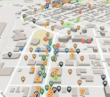
Unlock the Power of Map Builder: A Comprehensive Guide
Maps are windows to the world, and in today's digital age, building your own customized maps has never been easier. Whether you're a traveler planning an epic road trip, a business owner looking to visualize customer locations, or an educator creating engaging lessons, a map builder can be your go-to tool for transforming your ideas into interactive, informative, and visually stunning maps. In this article, we'll explore the concept of a map builder, its benefits, and how you can use it to bring your mapping visions to life.
What is a Map Builder?
A map builder is a software or online platform designed to simplify the process of creating maps. It offers a user-friendly interface and a wide range of features that allow you to customize your maps according to your specific needs and preferences. Map builders are versatile tools suitable for various purposes, from simple location markers to complex geographical data visualization.
Benefits of Using a Map Builder:
User-Friendly Design: Map builders are typically designed with ease of use in mind, making them accessible to individuals with varying levels of technical expertise. You don't need to be a GIS (Geographic Information Systems) expert to create compelling maps.
Customization: Map builders offer extensive customization options. You can choose from various map styles, add markers, lines, polygons, labels, and even incorporate your own data sets to create maps tailored to your needs.
Interactivity: Many map builders allow you to add interactive elements to your maps. This can include pop-up information windows, clickable links, and the ability to toggle layers on and off for a dynamic user experience.
Data Integration: You can import data from various sources, including spreadsheets, GPS devices, or APIs, and visualize it on your map. This is particularly valuable for businesses and researchers who need to analyze geographic data.
Real-Time Updates: Some map builders support real-time data, enabling you to display live information such as traffic updates, weather conditions, or IoT (Internet of Things) sensor data.
Sharing and Embedding: Once you've created your map, you can easily share it with others by generating a link or embedding it on your website, blog, or social media profiles.
How to Use a Map Builder:
Using a map builder is typically straightforward, and the exact steps may vary depending on the platform you choose. Here's a general overview of the process:
Choose a Map Builder: Select a map builder platform that aligns with your project's requirements and your skill level. Popular options include Google Maps, Mapbox, and Esri's ArcGIS Online.
Import or Create Data: Upload your geographic data, whether it's a list of locations, a shapefile, or a spreadsheet with coordinates. Some map builders also offer the option to draw features directly on the map.
Customize Your Map: Customize your map's appearance by selecting a suitable base map style, choosing colors, adding markers and labels, and setting the map's zoom level.
Add Interactivity: If desired, enhance your map with interactive features like pop-up windows, clickable icons, or layer toggles.
Review and Test: Before finalizing your map, review it for accuracy, aesthetics, and functionality. Make sure it effectively communicates your intended message.
Share Your Map: Once you're satisfied with your map, share it with your target audience by generating a link or embedding it where it's most relevant.
Conclusion:
A map builder is a versatile tool that empowers individuals and organizations to create maps that are both informative and engaging. Whether you're telling a story, making data-driven decisions, or simply exploring the world, a map builder can help you bring your mapping visions to life with ease. So, go ahead and start crafting your world today, one map at a time!
0 notes
Text
Who Can Benefit from Using a Map Builder?
Map Builders are versatile tools with a wide range of applications, making them valuable for various individuals and industries. Here's a breakdown of who can benefit from using a Map Builder:
1. Game Developers:
Game developers can create immersive worlds and levels using Map Builders. These tools allow them to design terrain, place assets, and define gameplay elements, making it essential for crafting engaging gaming experiences.
2. Content Creators:
Content creators, including YouTubers and streamers, can use Map Builders to generate unique environments for their content. Whether it's for virtual tours, storytelling, or creative showcases, Map Builders offer a canvas for their imagination.
3. Architects and Urban Planners:
Professionals in architecture and urban planning can utilize Map Builders to visualize and present their designs. These tools assist in creating 3D models of buildings, landscapes, and entire cities, aiding in client communication and project planning.
4. Education and Training:
Educators and trainers can use Map Builders to develop interactive educational materials. They can recreate historical sites, simulate scientific experiments, or build training environments for various professions.
5. Cartographers and GIS Professionals:
Map Builders are invaluable for cartographers and Geographic Information System (GIS) specialists. They can create custom maps for research, analysis, and decision-making in fields such as environmental science, urban planning, and geospatial mapping.
6. Event Planners:
Event planners can use Map Builders to design event layouts and floor plans. This helps in visualizing the event space, optimizing logistics, and ensuring a smooth execution of events, whether they are conferences, trade shows, or weddings.
7. Tourist and Travel Industry:
Travel agencies and tourism websites can benefit from Map Builders by creating interactive maps that showcase tourist destinations, hiking trails, or historical landmarks, making it easier for travelers to plan their trips.
8. Virtual Reality (VR) and Augmented Reality (AR) Developers:
Developers in the VR and AR industry can use Map Builders to build immersive virtual and augmented reality experiences. These tools provide the foundation for creating realistic and interactive virtual worlds.
9. Environmental Conservationists:
Conservationists and researchers can use Map Builders to create detailed representations of ecosystems and wildlife habitats. This aids in planning and monitoring conservation efforts and can be crucial in preserving endangered species.
10. Hobbyists and Enthusiasts:
Finally, hobbyists and enthusiasts interested in map-making, model-building, or virtual world creation can explore their creative side with Map Builders, turning their passions into tangible digital projects.
In conclusion, Map Builders cater to a diverse audience, ranging from professionals in various fields to creative individuals looking to express themselves digitally. These tools empower users to visualize, create, and share their ideas and visions in a virtual space, unlocking countless possibilities across industries and interests.
1 note
·
View note