#Interactive maps
Explore tagged Tumblr posts
Visit Tumblr Blog
Explore Tumblr blogs with no restrictions, modern design and the best experience.
Last Seen Tumblr Blogs


Fun Fact
The total number of visits Tumblr.com received during January 2021 is 327 million.
Text
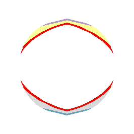
"The world's coral reefs are close to 25 percent larger than we thought. By using satellite images, machine learning and on-ground knowledge from a global network of people living and working on coral reefs, we found an extra 64,000 square kilometers (24,700 square miles) of coral reefs – an area the size of Ireland.
That brings the total size of the planet's shallow reefs (meaning 0-20 meters deep) to 348,000 square kilometers – the size of Germany. This figure represents whole coral reef ecosystems, ranging from sandy-bottomed lagoons with a little coral, to coral rubble flats, to living walls of coral.
Within this 348,000 km² of coral is 80,000 km² where there's a hard bottom – rocks rather than sand. These areas are likely to be home to significant amounts of coral – the places snorkelers and scuba divers most like to visit.
You might wonder why we're finding this out now. Didn't we already know where the world's reefs are?
Previously, we've had to pull data from many different sources, which made it harder to pin down the extent of coral reefs with certainty. But now we have high resolution satellite data covering the entire world – and are able to see reefs as deep as 30 meters down.
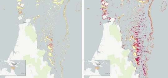
Pictured: Geomorphic mapping (left) compared to new reef extent (red shading, right image) in the northern Great Barrier Reef.
[AKA: All the stuff in red on that map is coral reef we did not realize existed!! Coral reefs cover so much more territory than we thought! And that's just one example. (From northern Queensland)]
We coupled this with direct observations and records of coral reefs from over 400 individuals and organizations in countries with coral reefs from all regions, such as the Maldives, Cuba, and Australia.
To produce the maps, we used machine learning techniques to chew through 100 trillion pixels from the Sentinel-2 and Planet Dove CubeSat satellites to make accurate predictions about where coral is – and is not. The team worked with almost 500 researchers and collaborators to make the maps.
The result: the world's first comprehensive map of coral reefs extent, and their composition, produced through the Allen Coral Atlas. [You can see the interactive maps yourself at the link!]
The maps are already proving their worth. Reef management agencies around the world are using them to plan and assess conservation work and threats to reefs."
-via ScienceDirect, February 15, 2024
#oceanography#marine biology#marine life#marine science#coral#coral reefs#environment#geography#maps#interactive maps#ai#ai positive#machine learning#conservation news#coral reef#conservation#tidalpunk#good news#hope#full disclosure this is the same topic I published a few days ago#but with a different article/much better headline that makes it clear that this is “throughout the world there are more reefs”#rather than “we just found an absolutely massive reef”#also included one of the maps this time around#bc this is a really big deal and huge sign of hope actually!!!#we were massively underestimating how many coral reefs the world has left!#and now that we know where they are we can do a much better job of protecting them
448 notes
·
View notes
Text
How to Create a Virtual Tour with a Map 🌍✨
Want to create a virtual tour of your favorite spots or hidden gems? With the right tools, it’s super easy to build an interactive map that lets others explore a place—without leaving their homes! Here’s how you can create a virtual tour with a map that will take our followers on a journey.

1. Pick Your Locations
First, decide where you want to take people. It could be a walk through your hometown, a tour of a museum, or even a virtual trip to iconic landmarks around the world. The key is to choose locations that you can share fun facts, images, or stories about. These could be anything from historical landmarks to cool cafes or parks you love.
2. Build Your Map
Once you have your locations, it’s time to plot them on a map. There are several platforms out there that let you create custom maps. You can drop pins on each spot and add details like photos, descriptions, and videos to make it feel more interactive. It’s like creating your own personalized travel guide!

3. Add Descriptions & Media
Now, this is where the fun begins. For each stop on your map, write a brief description. It could be a fun fact about the place, a personal memory, or even a suggestion for what to do when you get there. You can also spice things up by adding photos or even short videos to make the virtual tour feel more immersive.

4. Make It Interactive
The best part of a virtual tour is that it’s interactive! Make sure your map lets people click through each stop and explore on their own. With the right tools, you can even customize the route to take users on a seamless journey from one place to the next. It’s like they’re walking through the locations with you, without leaving their home.

5. Share Your Tour
Once your virtual tour is ready, it’s time to share it! Post your map link on Tumblr, and invite your followers to explore the world with you. You can also include a few fun captions or highlights for each location to keep them engaged as they click through the map.
Creating a virtual tour is an awesome way to share your adventures and give your followers a peek into places they might not be able to visit otherwise. Ready to start your own virtual tour? The world is waiting to be explored .
CONCLUSION:-
Creating a virtual tour with a map is a powerful way to bring locations to life, whether for businesses, education, or personal storytelling. With the right tools, anyone can craft an engaging, interactive experience that enhances accessibility and engagement. If you're looking for a seamless way to build and share your virtual tours effortlessly, platforms like MAPOG can be a game-changer, offering intuitive features that make the process smooth and professional. Start exploring the possibilities today and transform the way people experience places—virtually!
2 notes
·
View notes
Video
I love this so much
Here are the lighthouses of Europe. The map is even better than it might seem at first glance: the colors are the real colors, the patterns are the real patterns, and the size of the dots is the distance at which each light is visible.
Interactive map: https://geodienst.github.io/lighthousemap/
by @emollick
18K notes
·
View notes
Text
How to Use Interactive Maps for Guided Tours
Have you ever wandered through a historic city, nature trail, or museum and wished for a more immersive way to explore? Traditional paper maps or static guides can only do so much. That’s where interactive maps come in—offering an engaging and dynamic way to enhance guided tours for travelers, history buffs, and adventure seekers alike.
Whether you're organizing a walking tour, a self-guided exploration, or a heritage trail, interactive maps can transform the experience. Let’s dive into how you can create a custom map to make your tour more informative, engaging, and memorable.
What Are Interactive Maps, and Why Use Them for Tours?
Interactive maps are digital maps that allow users to engage with locations by clicking on points of interest, viewing additional details, watching embedded media, and even following guided routes. Unlike static maps, these provide a dynamic experience where users can:
Explore at their own pace – No need to rush; users can engage with locations as they go.
Access rich multimedia content – Add images, audio clips, videos, and historical facts.
Follow customized routes – Tailor itineraries for different interests and experience levels.
Navigate seamlessly – Use GPS integration to guide visitors efficiently.
Imagine walking through a historic district where each landmark on your map comes to life with a short video, archival photos, or an audio story. That’s the power of an interactive travel map.
How Do You Create a Custom Map for a Guided Tour?
Let’s break down the steps to designing a compelling interactive map for guided tours.
1. Choose the Right Mapping Tool
To create a map, you need a custom map creator that allows easy customization and sharing. Platforms like Mapme provide intuitive tools for adding points of interest, embedding media, and designing an engaging user experience.
2. Define the Tour’s Theme and Purpose
What story are you trying to tell? Are you designing a historic city walk, an art gallery tour, or a nature hike? Defining your focus helps structure the map effectively.
Examples:
Historical Tour: Mark key landmarks and add archival photos.
Food Tour: Pinpoint the best local restaurants with reviews and signature dish highlights.
Nature Trail: Highlight scenic viewpoints, rest stops, and flora/fauna descriptions.
3. Add Key Locations and Descriptions
Once your map is set up, start adding key locations. Each point should include:
A clear title (e.g., “Old Town Hall – Built in 1800”)
Engaging descriptions (Tell a story rather than listing facts)
Multimedia content (Photos, videos, and audio clips enhance the experience)
4. Design an Easy-to-Follow Route
Guided tours work best when they follow a logical path. Use waypoints and path-marking features to create a seamless flow.
Tips:
Number your locations in sequence to help users follow along.
Use color coding to differentiate stops (e.g., food spots in blue, historical sites in red).
Offer alternative routes for different interests or accessibility needs.
5. Integrate GPS and Interactive Features
A great tour map should be user-friendly and provide real-time navigation. Adding GPS integration ensures visitors can easily find their way without needing additional directions.
Interactive features to consider:
Augmented reality overlays for a futuristic experience.
Audio guides that play automatically when reaching a stop.
User-generated content where visitors can leave reviews or comments.
FAQs
Q: Can I create an interactive travel map without technical skills?
A: Yes! Many platforms like Mapme offer no-code solutions, allowing anyone to build a professional-looking map without programming knowledge.
Q: Do these maps work offline?
A: Some platforms allow offline access, but many require internet connectivity for full functionality. Consider offering downloadable PDFs as a backup.
Q: How do I share my custom map with users?
A: You can distribute your map via a shareable link, embed it on a website, or provide QR codes at tour starting points for easy access.
Q: Can businesses benefit from interactive maps for tours?
A: Absolutely! Restaurants, museums, and tourism boards can use them to promote local attractions, showcase hidden gems, and enhance visitor engagement.
Enhancing Your Tour with Mapme
If you’re looking for an easy way to build an interactive map for guided tours, Mapme is a great solution. It allows you to create a visually appealing and user-friendly experience with multimedia integration, custom routes, and GPS navigation.
Next time you’re planning a guided tour, think beyond the traditional brochure. A well-designed interactive map can make your tour more immersive, engaging, and memorable.
0 notes
Text
DB’s S-Bahn Mitteldeutschland S2 (Railway, Service) Map (Maps) (Railways) (Real Filming Locations)

Article & Map by @warrenwoodhouse #warrenwoodhouse
Icons ©Deutsche Bahn AG
#warrenwoodhouse#2024#interactive maps#map#germany#google maps#maps#.map#.gmap#real life#realfilminglocations#db#deutschland#deutsche bahn#s-bahn#s bahn#railways#railroads#railroad#railway#trainsimworld
0 notes
Text

0 notes
Text
Can you tell where my roadtrip was? 😂

this seems self-centered you know “stereotypical American bs” but I’m curious
11K notes
·
View notes
Text
"Support all victims" until the victim identifies as transage due to their trauma, then they must be trying to get with children!
"Support all victims" until they identify as transharmed/transharmful, they must be glorifying and saying real abuse is okay!
"Support all victims" until they work out their trauma in a conabuse relationship, they must have been manipulated into it by their conabuser!
"Support all victims" unless they formed a paraphilia due to their trauma then their evil!
"Support all victims" until it's someones source memories instead of their bodies.
Supporting all victims does not mean picking and choosing what victims deserve to be supported, all victims need support, no matter how 'wrong' you think their mere existence is.
#rq 🌈🍓#transid#rq community#pro radq#radq interact#radq please interact#radqueer#radq safe#pro rq 🌈🍓#transage#transage safe#map safe#zoo safe#para safe#transid safe#implied abuse#implied sa#implied csa
208 notes
·
View notes
Text
watching the sdcc panel and i am just very :) about how sweet their answers to “what are some of the micro moments from the game that have stuck with you the most over the years?” are. taliesin saying what the fuck is up with that which was the first like The Party Gets To Know Each Other moments of c3. travis saying asking his wife if he could kiss her in campaign. marisha going way back to the cannonball competition in campaign one. ashley choosing the beauyasha date but also just the silly goat noise matt made. liam adding onto that to compliment matt roleplaying grass so well and then saying his favourite moment was writing a story for laura and reading it to her as caleb for jester. and then matt saying that was his answer, and that his favourite moments of the game are when they find ways to give gifts to each other whether tangible or not. and sam saying his favourite moments have less to do with the story and is more so when he can just. see his friends across the table from him. when marisha perches and when laura and ashley are (badly) drawing dicks and liam saying he loves when sam sneezes and ashley tells him to stop it and just. yeah. they Are an extremely popular online powerhouse, but i’m so happy that they’re also friends building a world together out of gifts to and love for one another.
like i Am so enamoured with the characters and the world of exandria but the moments when you can feel the love that those people have for each other reach out from behind the stained glass of their performances (to steal a metaphor from brennan lee mulligan) are so extremely special and i am endlessly grateful that they decided to share their silly little home game with the world.
#it’s just the. laura and travis’ characters always being supportive of one another when they’re facing hardship#taliesin and marisha consistently making characters who challenge one another and still protect each other relentlessly#all of them being so fond of ashley’s characters always and literally seeing them light up in c1 episodes when ash got to join in person#sam and liam always making characters who offer one another reprieves into kindness that they don’t always get in the campaign setting#liam making orym after falling in love with keyleth as vax#marisha making laudna after matt’s storytelling with delilah and choosing vex as her body double#ashley using ‘i would like to rage’ and matt having kord ask her where she finds her strength#laura and matt always weaving these deeply complicated and emotional interactions between a daughter and a father#the gasps and yells and clapping when matt makes cool sound effects or reveals a map or breaks/ends on a cliff hanger#them ending both campaign 1 and 2 with ‘what a great/nice story’ and travis saying ‘let’s do it again!’#and it’s like. yes yes i love the comics and i’m a fan of tlovm but . seeing this well produced thing that somehow mimics#the feeling i get sitting in my living room laughing with my roommates about my ranger’s giant rat failing to climb stairs#it’s very special it’s very sweet#critical role#sdcc 2023#taliesin jaffe#travis willingham#marisha ray#ashley johnson#liam o’brien#matthew mercer#laura bailey#sam riegel#cr cast#critical role cast#my posts
3K notes
·
View notes
Text
This even works in your phone browser!
hey! did you know that the mars reconnaissance orbiter, a nasa spacecraft in orbit around mars since 2006, has imaged nearly the entire planet's surface at a resolution of 6 meters per pixel?
did you also know that scientists have put all that data into the form of a 3D globe that can be explored for free in your browser?
it's the coolest fucking thing and i've spent hours and hours just getting lost in it


3K notes
·
View notes
Text
Top 5 Benefits of Interactive Maps in 2024
In the fast-paced digital landscape of 2024, interactive maps have emerged as indispensable tools that go beyond traditional boundaries. In this blog post, we will delve into the top five benefits of interactive maps, focusing on the prowess of map builder and their transformative impact on real estate. Along the way, we'll introduce you to Mapme, an online platform designed to make map creation a breeze.
1. Revolutionizing Map Creation with Map Builders:
The landscape of map creation has evolved significantly with the advent of sophisticated map builders. These tools, such as the user-friendly platform Mapme, empower individuals and businesses to effortlessly create stunning and dynamic interactive maps. With drag-and-drop functionalities and customizable templates, map builders are democratizing cartography, allowing users to bring their visions to life without the need for extensive technical expertise.
2. Engaging Users with Interactive Maps:
In the dynamic world of 2024, interactive maps have proven to be highly engaging across diverse industries. Whether you're planning a trip, exploring a new neighborhood, or seeking a map for real estate options, interactive maps provide a visually compelling and informative experience. Users can zoom in, click on specific points of interest, and access relevant information, making the exploration both interactive and enjoyable.
3. Real-Time Data Integration for Informed Decisions:
The demand for real-time information is paramount in 2024, and interactive maps rise to the occasion. Map builders, including Mapme, facilitate the seamless integration of up-to-the-minute data. This feature is particularly beneficial for real estate professionals, enabling them to create maps for real estate showcasing property listings with current availability and pricing. The ability to integrate real-time data enhances decision-making processes and fosters transparency between stakeholders.
4. Facilitating Collaboration through Map Creation:
Collaboration lies at the core of successful ventures, and interactive maps streamline communication among team members and stakeholders. Mapme, a prime example, offers collaborative features that enable multiple users to work on a map simultaneously. In real estate, teams can collectively create and update property maps, ensuring everyone is on the same page and contributing to project success.
5. Strategic Marketing with Interactive Real Estate Maps:
In the real estate industry, the impact of interactive maps is revolutionary. The ability to create visually appealing and informative maps enhances property marketing efforts significantly. Prospective buyers or tenants can explore neighborhoods, view property details, and even take virtual tours—all through interactive maps. Mapme's intuitive platform facilitates real estate professionals in creating maps for real estate, showcasing properties in a visually stunning and informative way, attracting more attention and potential clients.
In conclusion, the benefits of interactive maps in 2024 are vast and transformative. Thanks to advanced map builders like Mapme, individuals and businesses can harness the power of interactive maps to enhance user engagement, integrate real-time data, facilitate collaboration, and revolutionize marketing efforts, particularly in the dynamic landscape of real estate. As we navigate the future, interactive maps will undoubtedly continue to redefine the way we interact with our surroundings and information.
0 notes
Text
Hatake lore…


The Uchiha actually accepted bc the Senju are slowly monopolyzing the entire agricultural sector of Fire country and because of that the Uchiha are kinda starving, but shhhhh
Funny comic says it’s bc Hatake veggies are yummy (just try to eat the ones without fetuses inside)


#srry for the handwriting but it just looks better that plain text#I do actually have a sort of logical explanation for why they do this#it has to do with their bloodline limit#you’re laughing. children were killed and you’re laughing#uchiha clan#Hatake clan#Hatake clan lore#warring states era#is this an excuse to make the Hatake and Uchiha interact?#…yah but it’s still funny#the guy with the moustache is actually Kakashi’s great great grandpa#he’s chill af#let’s see if I’m actually able to post what I got going on for my version of the Hatake#I’m making all of this up for a separate au btw#but at the pace I’m going that may never get to see the light of day#did u know I spent two whole days trying to figure out in which direction the Naka river went?#fuck you and your vage maps Kishimoto#at the end I came to the conclussion#that the cardinal directions in Naruto depend purely on what brings more hype moments and aura to the scene#ma art
169 notes
·
View notes
Text
First Rail’s GWE Great Western Express (Historical Railway, Service) Map (Maps) (Railways) (Real Filming Locations)

Article & Map by @warrenwoodhouse #warrenwoodhouse
Icons ©Crown copyright
#warrenwoodhouse#2024#gaming#real life#realfilminglocations#maps#google maps#interactive maps#map#railways#railroad#railway#trainsimworld#gwr#great western railway#tfl#elizabeth line#uk#gwe
0 notes
Text
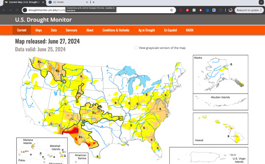
The U.S. Drought Monitor (USDM) is a map released every Thursday, showing where drought is and how bad it is across the U.S. and its territories. The map uses six classifications: normal conditions, abnormally dry (D0), showing areas that may be going into or are coming out of drought, and four levels of drought: moderate (D1), severe (D2), extreme (D3) and exceptional (D4).
They have many many excellent tools for viewing their data, which are well displayed and easily interactive.
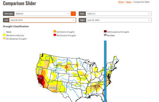
Several different agencies take turns updating the map :)
0 notes
Text


happy daddy's day! just got out of the shower 💕 a lil' tease for spanking 🩷😊
#daddy’s slvt#map safe#und4rag3#@ams please interact#barelylegal#r@pe wh0re#m@pba1t#ag3 g4p#p3d0d4d#j41lb@1t
142 notes
·
View notes
Text
Biblically accurate rqballs


#rq 🌈🍓#transid#pro radq#radq interact#radq please interact#radqueer#pro rq 🌈🍓#rq community#radq safe#transage#rqballs#rqball#zoophillia#zoo safe#map safe
144 notes
·
View notes