#30daymapchallenge
Explore tagged Tumblr posts
Visit Tumblr Blog
Explore Tumblr blogs with no restrictions, modern design and the best experience.
Last Seen Tumblr Blogs


Fun Fact
Tumblr has 4 main sources of revenue.
Photo
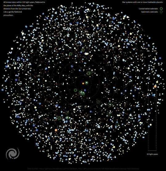
A star map of our 100 light-year radius neighborhood, highlighting where we might find habitable planets — made for the #30DayMapChallenge that just started over on Twitter
242 notes
·
View notes
Photo

Ireland has some amazing neolithic sites, like Newgrange. But you will also often be cycling past a field and see a strange looking standing stone, and it is, a prehistoric standing stone, in the middle of a random field. #30DayMapChallenge #Day1 #Points https://t.co/XBgpGD3wA2
231 notes
·
View notes
Photo

#30daymapchallenge day 10 Raster. Here’s a hillshade of the #hymalayas https://www.instagram.com/p/CWGsWuMtCNh/?utm_medium=tumblr
3 notes
·
View notes
Text
With this, I am commencing my submission for the #30DayMapChallenge for 2023 🗺

The categories outlined is similar to that of last year but I am never going to hate this repetition. How can I? It's a basics of making maps and there's so much to learn from the single-word theme.
Any aspiring map-makers out there? Let's share our maps for this wonderful month of November under the #30DayMapChallenge 2023!
1 note
·
View note
Text
30 Day Map Challenge

I tried to do this last year, but completely forgot about it until about halfway through November. I figured this probably would be the best way to expand my portfolio before I graduate. I'm most excited to complete the 5 minute map, a bad map, music and "out of my comfort zone", as well as the color Fridays! Feel free to follow along for my journey to complete the #30DayMapChallenge on my instagram @jessie.makes.maps
1 note
·
View note
Text
A small, #relaxing #timeline where I’m #drawing another blank #map. Can you guess what it’s about this time? 🗺️✏️✨
#30DayMapChallenge
0 notes
Text
youtube
We’re working with OpenStreetmap for Day 15 of the #30daymapchallenge. We’ll learn how to use the QuickOSM plugin for #QGIS to download data and then style that data similarly to the OpenStreetMap tiles. Happy #GISDay!
0 notes
Photo


Some of my #30daymapchallenge submissions so far.
0 notes
Photo

#30DayMapChallenge Day 3 "Polygons" Where elevation exceeds 2000m
by @Topi_ve
110 notes
·
View notes
Photo

This bivariate map shows CO2 emissions produced by food consumption vs meat consumption across the world. Areas in navy blue are countries with high meat consumption and high CO2 emissions.
by @vanessatebbitt
87 notes
·
View notes
Text
youtube
For Day 13 - Choropleth I take the map we made on Day 3 - Polygons and improve it using advice from the book "Making Maps".
0 notes
Text
youtube
It's #30daymapchallenge Day 12 - South America and we're making a map of the continent using the flags of each country. France also makes an appearance.
0 notes
Text
youtube
It's Day 11 of #30daymapchallenge and the theme is "Retro". In this video I show you how to make a map like the ones featured in the 80s classic "WarGames" using #QGIS. That means lots of glowing lines, simple geometric symbols, console fonts and secret military data! Or maybe just public military data…
0 notes
Text
youtube
Today I livestreamed on Windows! I used #QGIS to create a map of the countries & sovereignties that make up the Caribbean Sea. Lots of data filtering, labels using expressions, customized callouts, layout struggles and pronunciation learning in this one.
0 notes
Text
youtube
For Day 9 of #30daymapchallenge we're collecting point data into a hexagon grid and styling it based on the number points in each hex using #QGIS.
0 notes
Text
youtube
Learn how to use Balloon Callouts and synchronize Symbology/Label coloring in #QGIS. That’s right - it’s Day 8 of #30daymapchallenge and we’re mapping western African countries for fun and learning!
0 notes