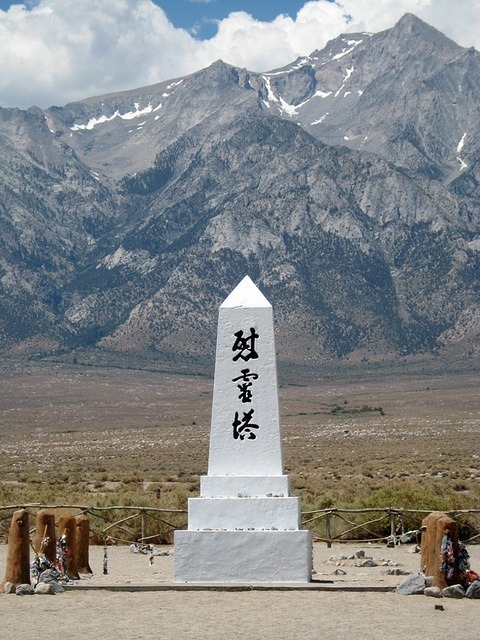
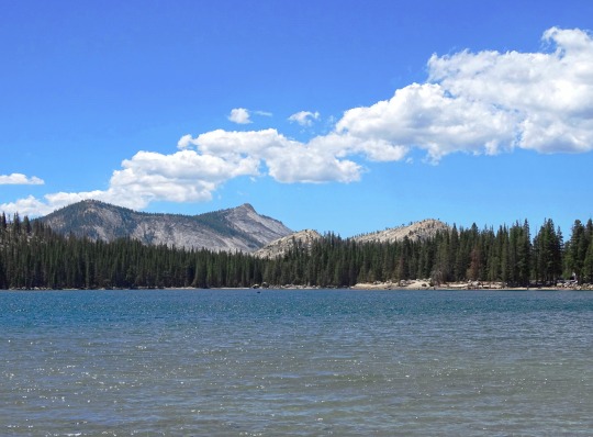
#Central Sierra Nevada
Video
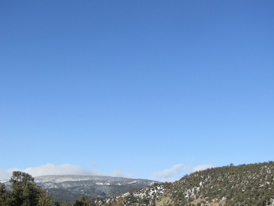
Get Yourself to the Ancient Bristlecone Pine Forest by Mark Stevens
Via Flickr:
While walking the Discovery Trail and taking in views of the ancient bristlecone pines in this portion of the Schulman Grove and Inyo National Forest. The view is looking to the southwest with a distant view of the Sierra Nevada mountains.
#Ancient Bristlecone Pine Forest#Azimuth 201#Birch Mountain#Blue Skies#California and Oregon Road Trip#Central Sierra Nevada#Cloudripper#Day 2#Discovery Trail#DxO PhotoLab 5 Edited#Forest#Forest Landscape#Forest Mountain#Great Basin Bristlecone Pine#Great Basin Ranges#Hillside of Trees#Intermountain West#Inyo National Forest#Landscape#Landscape - Scenery#Looking SW#Methuselah#Methuselah Grove#Middle Palisade#Mount Agassiz#Mountain Peak#Mountains#Mountains in Distance#Mountains off in Distance#Mountainside
4 notes
·
View notes
Text

Man I miss the rain, it's been years of drought in Northern California. Had to move a bit east and it's nothing but snow, I love the sound of raindrops against my window. It's probably one of the few things that truly make me feel at ease. Snow, a newer experience to me in my 31 years of life, is the most miserable thing on this planet outside of Chrismas movies and postcards. Anyways here's a little chop I did, not the first or the last, and certainly not the best because this was just a quick cookup. Still, the sample speaks for itself it is just a few bars of melancholy and soul.
#rain#raining#thunderstorm#winter#lofi#boombap#beats#sampling#kevssecretstash#lofihiphop#instrumental#audio journal#northern california#sierra nevadas#central valley#stockton#sacramento#san jose#san francisco#marysville
8 notes
·
View notes
Link
The California chill: State recorded fifth-coldest March in 129 years amid storms, snow
Apr. 11, 2023 - LA Times
Californians who feel like March was one of the coldest and wettest they've endured have the data on their side.
Data from the National Oceanic and Atmospheric Administration show that last month was the fifth-coldest March in California since 1895, the first year in the agency's database. The average temperature across the state was 44.2 degrees, nearly 9 degrees lower than the average of 53.1 degrees from March 2022...
Daniel Swain, a climate scientist at UCLA, posted Monday on Twitter that "a few regions of Northern California just experienced their coldest March on record.”...
With the cold weather came substantial precipitation across the state. The wet season was the "wettest on record in some parts of interior" California, Swain tweeted, referring to the Central Valley and central and southern Sierra.
With more than 27 inches of precipitation on average, California's recent wet season ranked as the eighth wettest. Eight counties — El Dorado, Amador, San Joaquin, Calaveras, Tuolumne, Alpine, Mono and Fresno — saw their most precipitation on record from November through March...
#orgone#orgone energy#orgonite#weather#climate#rain#snow#record rainfall#record snowfall#sierras#sierra nevada mountains#central valley#flooding#NOAA#planetary healing#geo-restoration#free energy
2 notes
·
View notes
Text
SCREAMING THROWING UP SHITTING MY PANTS

#obviously this region is more losely based on the real place than previous ones#but still aaaaaah#and i want to learn so bad what elements of each part of the country they have used!!#like for example we already know the big central city even if by location should be modelled after madrid is modelled after madrid#barcelona and even toledo (surrounded by a big river just as the tajo in toledo!!)#also location wise toledo is closer as well#i would live in the big vortex in the center lol#and there's a lot of cities which i'm excited for!!#the biomes are also super varied and i still love that the snowy area is in the north even if it's named after sierra nevada#(which is in the south lmao)#also it looks fucking huge#usually the scales are not that off in pokemon regions#so seeing the buildings that tiny impress me a lot#anyways hello paldea you're officially my favourite region :)
9 notes
·
View notes
Text
California Braces for Historic Blizzard: Sierra Nevada Under Threat

A powerful winter storm is set to unleash its fury on the Sierra Nevada from Thursday to Sunday, bringing record-breaking snowfall and blizzard conditions. ️
Here's what you need to know:
Up to 13 feet of snow is expected at the highest peaks.
Mountain travel will be impossible due to blizzard conditions with near-zero visibility.
This storm is different from previous ones:
Colder and originating from Alaska, not Hawaii.
Stronger jet stream will push the storm system inland.
Potential for record-breaking snowfall at UC Berkeley's Central Sierra Snow Lab.
Impacts:
Heavy snow expected at lower elevations, including foothills and parts of the Bay Area. ❄️
Strong winds exceeding 110 mph on the Sierra crest.
Possible power outages and disruptions. ⚡
Stay safe! ⚠️
Avoid travel to the Sierra Nevada unless absolutely necessary.
Prepare for potential power outages.
Stay informed of the latest weather updates.
#Blizzard#National Weather Service#UC Berkeley#El Niño#Andrew Schwartz#Heather Richards#Jack Lee#Anthony Edwards#Sierra Nevada#California#Tahoe City#Lake Tahoe#Alaskan#Pacific Ocean#Soda Springs#Central Sierra Snow Laboratory#West Coast#San Diego#Los Angeles#Santa Barbara#Gulf of Alaska#Hawaii#Arctic#Mount Hamilton#Mount Diablo#Bay Area#Grass Valley#Mendocino#Snow
0 notes
Text


California road trip
#california#road trip#San Francisco#Central Valley#inland empire#east bay#central coast#southern california#sierra nevada
1 note
·
View note
Note
yoooo where did you take your header?
pretty just like you :D
Little Baldie, a granite dome in Sequoia National Park. The view looks South across the Southern Sierra Nevada and a bit of the central valley, and the direction I'm pointing is Southeast, approximately where the High Sierra Trail runs
43 notes
·
View notes
Text
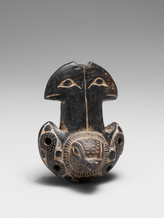
Ocarina
Tairona
1300–1500
Although numerous types of instruments survive from pre-conquest South and Central America, little is known of how they were used. Whistles, trumpets, and rattles in animal or human form probably had ceremonial functions or served as playthings. Smaller whistles in animal shapes, perhaps worn suspended from the neck, frequently have fingerholes that allow variation of pitch.
Flutes and bells are all that remain of many musical traditions of the Tairona people of the Sierra Nevada de Santa Marta region, Colombia. The importance of these metal, terracotta, and blackware instruments is evident in their carefully detailed incising and punctuation. The symbolic meanings of the effigies are obscure, and the relationship between the forms and their musical functions is unclear. It is believed that musical effigies served as talismans and were played to link the mortal and immortal realms.
source
27 notes
·
View notes
Text
"A parade of atmospheric river-fueled winter storms in California and other western states has erased the most extreme drought conditions for the first time since 2020 and more water is on the way, forecasters predict.
The U.S. Drought Monitor's latest conditions report shows no part of California is in the Extreme or Exceptional Drought designations that blanketed most of the state last summer.
Most of the central portion of the state is completely free of drought conditions from the latest readings on March 14. Parts of Northern and Southern California are still showing Abnormally Dry or Moderate Drought on the scale, while Moderate Drought conditions are still in place in parts of Siskiyou, Lassen, Modoc, Inyo and San Bernardino counties .

Record snowfall and rain have helped to loosen drought's grip on parts of the western U.S. as national forecasters and climate experts warned Thursday that some areas should expect more flooding as the snow begins to melt...
Jon Gottschalck, chief of the operational prediction branch at NOAA's Climate Prediction Center, said the start of the fire season in the Southwestern U.S. likely will be delayed."
-via CBS News, 3/16/23
And an update from 3/30/23
50% of California is now out of drought completely!
Couldn't find an article about this that didn't have a picture of drastic flooding, rip.
"Drought conditions across California continue to retreat thanks to heavy rain and historic snowfall that has battered the Golden State since late last year.
Data from the U.S. Drought Monitor released on Thursday shows that more than 50% of California is free of any drought classification for the first time since February 2020...
In November, virtually all of California’s Central Valley was deemed to be in an “exceptional drought,” the U.S. Drought Monitor’s worst classification.
As of [March 30th], California’s entire coastline was drought-free and only a small section of the Central Valley was considered “abnormally dry.” More significant drought conditions still exist in the northeastern and southeastern areas of the state...
California’s Sierra Nevada mountains are seeing record snowpack that will eventually melt and fill the state’s reservoirs. On Wednesday, Mammoth Mountain ski resort announced it had set a new all-time snowfall record."
-via KTLA, 3/30/23
#california#united states#drought#california drought#snowpack#mammoth#sierra nevada mountains#water reservoir#water conservation#rain#good news#hope
108 notes
·
View notes
Text
Flight impressions
11/16/1987. 4:04pm
We lifted off about 4 minutes ago. We soar above LA smog on flight 1895 bound from San Diego to Fresno with a stop in LA. We circle out over the Pacific. Tiny planes dart by far below. The earth hangs beneath all festooned in her riches of black, green and silver fox grey blue, like patterns in material art. It’s like watching an unreal movie.
We bank. The mountains hang in their mist as if in magic—a blue sky trim harkens and harbors a peace lite halo. The feeling is above it all.
4:11pm. The land below coddles a lake, holds it in grip like a child in a mother’s lap.
4:14pm. I’ll try out the field glasses. Flight stewardess just passed by. Don’t think I want anything. Peanuts ok.
4:14:39. We pass over the Tehachapi’s into the great Central Valley. The mountains caress down into the valley in a peaceful, almost seductivly sensual, sexual way. They gently feel their way neath velvet bed spread of valley’s sleep. A bright sun enters from left. A beautiful blue luster shimmers beyond.
About 4 plane cashes in the last 24 hours. I imagine the thought flits through all 60 or so minds on board. I feel safe aloft.
4:18pm I’ll try out the field glasses. Nope, don’t seem to work too well up here.
4:22pm. A bit of turbulence!!
4:28pm. A bell chimes. We begin our diescent. I perceive a drag of the engines. Broad solid rock wall of the Sierra Nevadas to the East. White cotton clouds, blue grey mist of day adds majesty. The sun peaking in on the west.
The clouds and mist mimic the sea in their attachment to the land—they hug up and cuddle and out to sea, they swell and crest in repetition.
4:36pm. The cabin grows much darker. Fasten seat belt. We begin descent into Fresno. Here, below, we find a peace not present over LA or San Diego. The cities sit like computer chips midst a green checker board.
We are space people. We truly live on a revolving jewel. Emerald of the sky. The mountains vanish to mist.. Feeling of falling.We drop from higher realms of reality to a lower physical place. We are blinded now of strength of rock mother, but, she is there all the same.
Now, the physical world reaches up to touch as time slows, speed slows, weight and velocity alter. Weighting down, down, down, down—flaps and wheels scream.
We give up freedom of the sky for security of the earth. But, they are at different speeds and places. We have seen. We shall not un see.
Pale grey, brown. Closer, closer, closer. Cars, highway, runway and—we land! 4:42:55pm
End of entry
Note: 3/24/2024
I had been in SanDiego for a criminal law class and to visit with my sister Zoe who lived there at that time.
I googled 4 plane crashes November 1987. The one that came up was flight 1713 that crashed on take off from Denver, Colorado’s Stapleton Airport on November 15,1987.. The pilots failed to properly de ice the wings and took off at too steep a pitch. Some on board died. The cause of the crash led to changes in aviation safety rules.
#11/16/1987#the feel of flight#the earth as the revolving jewel. Emerald of the sky#crash of flight 1713. 11/15/1987 Denver Stapleton Airport
9 notes
·
View notes
Video
Get Yourself to the Ancient Bristlecone Pine Forest by Mark Stevens
Via Flickr:
While walking the Discovery Trail and taking in views of the ancient bristlecone pines in this portion of the Schulman Grove and Inyo National Forest. The view is looking to the southwest with a distant view of the Sierra Nevada mountains.
#Ancient Bristlecone Pine Forest#Azimuth 201#Birch Mountain#Blue Skies#California and Oregon Road Trip#Central Sierra Nevada#Cloudripper#Day 2#Discovery Trail#DxO PhotoLab 5 Edited#Forest#Forest Landscape#Forest Mountain#Great Basin Bristlecone Pine#Great Basin Ranges#Hillside of Trees#Intermountain West#Inyo National Forest#Landscape#Landscape - Scenery#Looking SW#Methuselah#Methuselah Grove#Middle Palisade#Mount Agassiz#Mountain Peak#Mountains#Mountains in Distance#Mountains off in Distance#Mountainside
4 notes
·
View notes
Text
To my knowledge, there aren’t any fan-created cities in the Bioshock fandom….
Hidden deep in the mountains, a lighthouse stands as a beacon for all who seek the catacombs of Elysium.
Hello! I see that the mysterious hook has caught your attention! I’ve had an idea for a fan-created bioshock city for a while and would like to share the inklings and my thought process for a while.
If you’d like to, I’d love critique, feedback, etc on the ideas here.
While we know that there is always a man and a lighthouse, there were other categories I wanted to fulfill when creating this city and what I have for each:
A Man
As well as other interesting and important characters
Hook before a lighthouse- introduce the character.
Vaguely mid to young 20s, possibly a community college student, either likes urban exploration/ found footage content or is a hiker (possibly both)- something that would get him involved.
A Lighthouse
Nestled deep in the mountains, along a small pond and surrounded by ancient trees is a mysterious lighthouse that once stood as a beacon of hope but has not been seen in hundreds of years.
A City
The rise and fall of this civilization.
Elysium is a city underground in the southern Sierra Nevada range, roughly central to southern California.
The aesthetic of this one is inspired by underground cities found in Turkey, Etruscan tombs, and the Parisian catacombs.
Aesthetically, Rapture is cold and dark, Columbia is warm and bright, Polaris seems like it's going to be cold and bright. Elysium is warm and dark with materials like warm tuff, terra cotta, that sort of thing. Everything isn’t far off of being sepia toned, like aged paper.
A Time Period
Neither the golden age of the city nor game setting are modern day
The Golden Age: 1780s or so, Game Setting: roughly 2008-2014- the furthest back in time and closest to modern
A group of people unhappy with the newborn America leaves and finds a new home westward.
The architecture of the city is closely tied to some sort of inspiration from American history.
Neoclassical Architecture (all of the original government buildings and monuments in DC and such as well as historical homes like Monticello)
An Ideology
Showing the flaws of the ideology it was based on.
Everything connects to it.
There's some sort of critique of America and humanity.
This one would be centered on the Ancient Roman ideals that America pulled inspiration from.
Another main theme would be the value that people put in the past and the romanticizing and glorification of time periods long gone.
An Adam/ Lutece Particles parallel
Something similar to vigors and plasmids created from this parallel
Mutation/ mutated people caused by this.
The founders of this city settle here because they find a fruit/ berry that, when consumed, grants them immortality (although twisted). When the fruit is turned to wine with various additives, it gives them remarkable powers.
This is a reference to both the way that wine and intoxication was seen as divine and in the whole ‘eating the fruit of the dead’ sort of thing.
Some effects/ consequences of this process are being able to mold the self like clay to fit perfect mathematical beauty found in sculptures. Some are fused to the very walls of the caves as their world decays and they become an archeological dig in and of themselves, still alive but…
27 notes
·
View notes
Photo
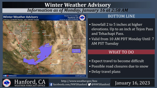
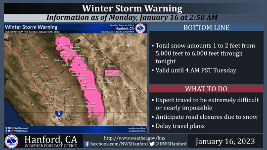


Snow Overnight, more on the Way
Jan. 16, 2023
Rain turned to snow yesterday afternoon, and we had a couple of inches overnight, which have melted off this morning here at around 5000 feet. At the higher elevations the snow is remaining and we are expecting another 2-5 inches later today into tomorrow.
The Sierras are forecast to get 1 to 2 feet of snow with this next storm, with possible “excessive rainfall” in the Sierra foothills. There are various weather advisories and warnings in effect for most parts of California today, including flood warnings for the already flooded valley and coastal regions.
#orgone#orgone energy#orgonite#orgonite gifting#weather#snow#rain#mountains#coast#central valley#flooding#sierras#sierra nevada mountains#tejon pass#tehachapi#frazier park#free energy#planetary healing#drought#climate
5 notes
·
View notes
Text
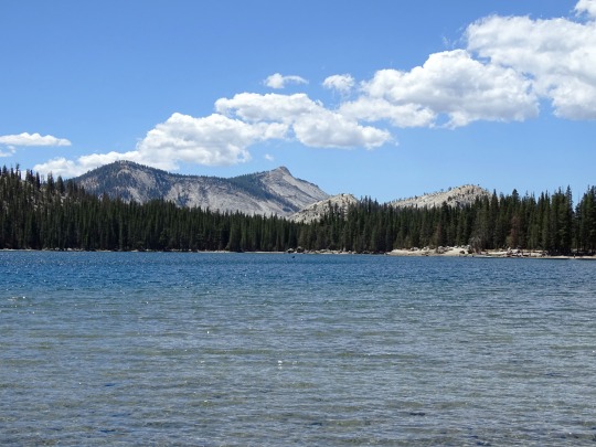
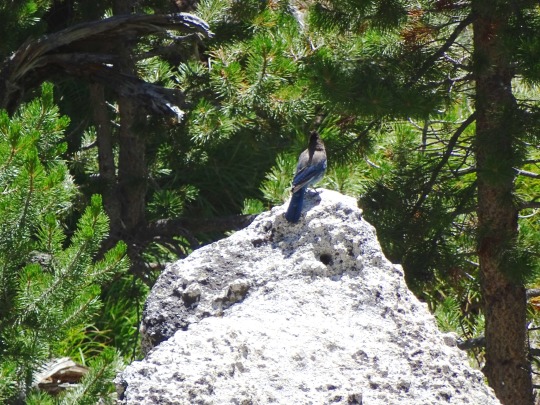
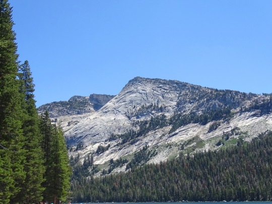
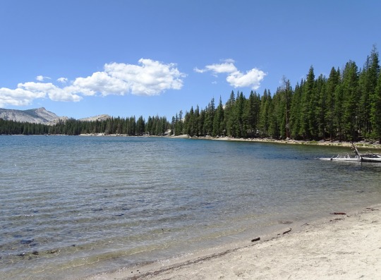


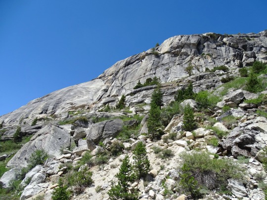


Yosemite National Park, CA (No. 6)
Yosemite National Park is located in the central Sierra Nevada. Three wilderness areas are adjacent to Yosemite: the Ansel Adams Wilderness to the southeast, the Hoover Wilderness to the northeast, and the Emigrant Wilderness to the north.
The 1,189 sq mi (3,080 km2) park contains thousands of lakes and ponds, 1,600 miles (2,600 km) of streams, 800 miles (1,300 km) of hiking trails, and 350 miles (560 km) of roads. Two federally designated Wild and Scenic Rivers, the Merced and the Tuolumne, begin within Yosemite's borders and flow westward through the Sierra foothills into the Central Valley of California.
Almost all of the landforms are cut from the granitic rock of the Sierra Nevada Batholith (a batholith is a large mass of intrusive igneous rock that formed deep below the surface). About five percent of the park's landforms (mostly in its eastern margin near Mount Dana) are metamorphosedvolcanic and sedimentary rocks. These roof pendants once formed the roof over the underlying granitic magma.
Source: Wikipedia
#Yosemite National Park#Sierra Nevada#Mono County#geology#flora#California#summer 2022#tourist attraction#landmark#landscape#countryside#USA#nature#forest#woods#fir#pine#rocks#travel#original photography#vacation#creek#granite#blue jay#bird#Tenaya Lake#lake shore#blue sky#clouds#wildlife
10 notes
·
View notes
Text
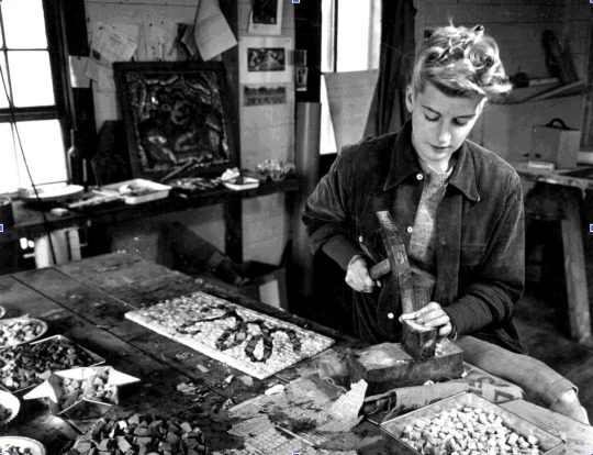
Jeanne Reynal B.1903, WHITEPLAINS, NEW YORK D. 1983
Jeanne Reynal (1903-1983) is a significant figure of the New York School, a mosaicist who showed with Betty Parsons Gallery. Reynal was dedicated to challenging expectations of the medium by creating, as she described, “a new art of mosaic, a contemporary and fresh look for this ancient medium.” Her work was largely abstract.
Born in White Plains, NY, Reynal apprenticed from 1930-38 with Boris Anrep, a Russian mosaicist working in Paris. This established her interest in working with the medium. Reynal spent the World War II years living in San Francisco, and in Sierra Nevada. Her first solo exhibition was held in Los Angeles in 1940.
Reynal’s father died in 1939, allowing her resources with which to build an art collection. She acquired a 1941 Jackson Pollock painting from Peggy Guggenheim’s gallery -- one of the first ever sales of a Pollock. At this time, Reynal developed a relationship with the first director of the San Francisco Museum of Modern Art: introducing her to the work of Pollock and other first-generation New York School artists, and helping to set the course of acquisitions and exhibitions at the museum. Reynal’s closest artist friend was Arshile Gorky, and his wife Agnes (known as Mougouch). Reynal would show her own work in the SFMoMA Annual exhibitions from 1940-46. During her West Coast years, Reynal also developed a friendship with Isamu Noguchi who had enrolled, voluntarily, in an internment camp to aid other Japanese-Americans. She would later collaborate with Noguchi on mosaics for tables of his design. Reynal was also associated with the Surrealists - many of whom were living in exile in the U.S. In 1945, Reynal took a six week visit to the Hopi, Zuni, and Navajo Indians with André and Elissa Breton as interpreter and guide.
Reynal moved to New York City in 1946. At that time, she further developed friendships with artists including Willem and Elaine de Kooning. In 1955, she married Thomas Sills, a largely self-taught African American painter. They traveled together across Russia, Turkey, Greece, and Italy in 1959 to further study the art of mosaic. In 1960, she was asked, by Elaine de Kooning, to take over the organization of a show of Abstract Expressionist women artists held in West Texas in 1960, at Dord Fitz Gallery. It was in this period that Reynal began exhibiting with Betty Parsons.
Reynal was the subject of a traveling solo exhibition, organized by the San Francisco Museum of Modern Art, in 1964. The same year, a monograph of her work, with essays by Elaine de Kooning, Dore Ashton, and Lawrence Campbell, was published. The solo show traveled to the Sheldon Museum in Lincoln, Nebraska, a city where, the following year, Reynal would create mosaic murals for the State Capitol building.
Reynal traveled with her husband, Sills, throughout South and Central America: Mexico, Guatemala, Honduras, Peru. She was influenced by indigenous art throughout her travels. In the early 1970s, Reynal began making totem sculptures utilizing mosaic tesserae and pieces of shell. These monumental works were exhibited at Betty Parsons and at the Art Association in Newport, Rhode Island. In the late 1970s, she made a series of portraits in mosaic (many of artist-friends), and depictions of animals.
Eric Firestone Gallery
25 notes
·
View notes
Text
“It sounds like the sea and approaches the size of Lake Tahoe. Its wind-driven waves are unexpectedly silky and warm. Tulare Lake seems to go on forever on the immense brown and green flat of California’s Central Valley, shimmering like a great blue mirage.
Three months have passed since the lake, which dates to the Ice Age, re-emerged in the basin that once held the largest body of freshwater west of the Mississippi River. Dammed dry by humans, it has periodically attempted a comeback, though rarely with the force seen after this winter’s storms.
First a trickle, then a flood, the water that coursed into the lake bed over a handful of months swallowed one of the nation’s largest and most valuable stretches of cropland in about the time it takes to grow a tomato. Thirty square miles, then 50. Then 100. Then more.
Now, at the onset of summer, Tulare Lake sits at about 168 square miles, trapped by thousands of acres of clay soil and the lack of a natural outlet, so big that it is best tracked by satellites. Caused initially by climate-amplified sheets of rain over the riversheds coursing through the Sierra Nevada, it is being fed by the melting snowpack that piled up in the mountains to near-record levels.
Detours and roadblocks bedeck its shores. Chemicals, manure and diesel pollute it. Palm trees and power poles poke from its surface. Day brings dragonflies. Dusk brings mosquitoes. Flocks of birds are settling in — swallows, wrens, ducks, egrets, chattering red-winged blackbirds.”
13 notes
·
View notes
Last Seen Blogs

ygriegamx
Y Griega

purogeekcr
Puro-Geek

babymibs
jwalker, AOMG and H1GHR music stan for life 😄😄

kamiyoki
kamiyoki

itzleon345
Bad Bitches, Gay Witches