#Chinatown 1905 project
Photo
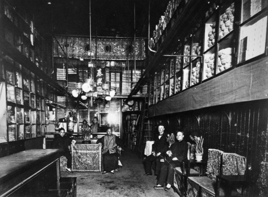
Shop in Chinatown, c. 1890. Photograph by Isaiah West Taber (from the Granger Collection, Historical Picture Archive).
Right Before Our Eyes: Rediscovering Ti Hang Lung & Co. on Dupont Street -- 都板街
The flash photo of the interior of a store in old San Francisco Chinatown has remained a favorite subject of reproductions over the years (even by mass outlets such as Wal-Mart). Unfortunately, the information about personages and the nature of the business have been lost to living memory. However, the photo contains a conspicuous sign and, thus, an important clue for researchers of old Chinatown more than 130 year later.
The sign appears in the upper center of the frame and reads 泰興 (pronounced as “Tie Hing” in Cantonese). The Langley directory of 1895 lists a business by the name “Ti Hang Lung & Co. 818 Dupont.“ The 1905 telephone directory also provides verification in the form of an English-language listing as “Ti Hang Lung & Co. Mds 818 Dupont.” This poses the question of whether the entry in English corresponds to the Chinese signage seen in the photo, particularly given the inconsistent English phonetic renderings of that day. Fortunately, the Chinese section of the 1905 contains a handwritten Chinese entry for the address of 818 Dupont. The name 泰興隆 (canto: “Tai Hing Loong”) appears in the first column at the bottom of this page excerpt as follows:
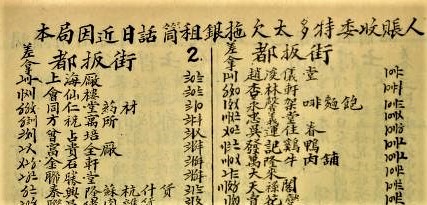
Chinese Exchange section for Dupont Street (都板街) from the Pacific States Telephone and Telegraph Co. directory of 1905 (from the collection of the San Francisco Public Library). The Chinese entry also shows the type of business as 蘇杭 什貨 (lit. “Suzhou-Hangzhou, assorted goods”; canto: “So-Hong sup faw”).
The telephone directory listing also confirms the type of merchandise sold by Ti Hang Lung as indicated by the cloth banner above its business name in the photo. Researcher Qi Liu wrote in response to this posting as follows:
“Suzhou-Hangzhou stores were fabric stores. At one time there were hundreds of these stores in the Siyi regions. The name suggested they sold the finest silk from those 2 cities. In reality, these stores also sold silk and cotton fabrics made in Guangdong. The items on the racks do appear to be rolls of fabrics. Even though the character on the right is not clear, one can conclude from the other 3 that the characters, from right to left, are from classic line 億則屡中.”
The Ti Hang Lung company survived the 1906 earthquake and fire, and it would reestablish itself as the “Ti Hang Lung, Importer & Exporter at 846 Grant Avenue in the rebuilt neighborhood (with its pre-1906 Chinese listing of 泰興隆 油糖 什貨).
This exercise in simple detective work raises the larger question of why public and private academic institutions, libraries, auctioneers, and publishers omit information that illuminates the images in their archives or for sale. For example, the Chinatown 1905 Project provides anyone interested in the people and places in old Chinatown with a map regarding their whereabouts.
As a wise man once told me, “your history is your own.” His unspoken corollary was that no one else would give a damn otherwise.
Asian American history may be American history, but it will take Asian Americans to re-appropriate at least the photographic legacy of their pioneer generations, probably with the help of A.I. engines because the task of compiling the information or setting the record straight remains voluminous and enormous.
#Ti Hang Lung & Co.#I.W. Taber#San Francisco Chinatown#Dupont St.#Chinatown 1905 project#1905 Chinese telephone book
1 note
·
View note
Text
Trip to Bridgeport
In the second week of Chicago excursions I was assigned to explore the neighborhood of Bridgeport. Bridgeport is located in the city’s south side, the neighborhood is confined to the north by the south branch of the Chicago river stretching south to Pershing Road. Laterally the neighborhood spans from the Union Pacific Railroad tracks in the east, to Bubbly Creek in the west. Bridgeport possesses the title as the oldest neighborhood in the city of Chicago, officially becoming Bridgeport Township in 1863. The history of Bridgeport and what survives today projects different stories about the neighborhood. Originally an Irish enclave of industry, Bridgeport today is ethnically diverse with many varying socioeconomic levels residing in the neighborhood.
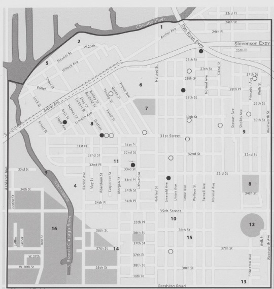
Map of Bridgeport
Industry began to boom in Bridgeport around 1830 when Stearns’ Quarry established a limestone quarry, dynamiting in the neighborhood until 1969 (Bloom, 2020). Industrialization swallowed the area, by 1905 the first privately owned and managed industrial park was established, called the Central Manufacturing District. The owners of the park invested into the neighborhood, building roads, public emergency services, a bank, and even leisure businesses. The demographic composed today in Bridgeport one will find around two of five residents being Asian, and one of five residents being of Hispanic dissent (Statistical Atlas, 2020). Immigrants from the old world flooded Bridgeport in aims for a working job. The Irish flooded the neighborhood first, soon to follow were northern and eastern European immigrants. Important to the neighborhood during the beginning of the 20th century was the railroad construction nearby (Bloom, 2020). Many of the workers who recently migrated were Mexican, who established homes in the neighborhood (Bloom, 2020). The remainder of the 20th century and leading to modern day, Bridgeport witnessed many Asian immigrants moving to the area. Being within close proximity to the city’s long-standing, well-established Chinatown district. Also residing near the historic district of Bronzeville, the population consists of African American and Hispanic dwellers.
What was once a booming sector of industry, today Bridgeport is now a cultural center for art and diversity. The neighborhood although slightly large on scale, is entitled to a strong sense of community. This strong sense of community may be one such production of the deeply rooted religious structures seen very visibly throughout the neighborhood. Apparent to the neighborhood is its nonsecular nature, with many ornate and magnificent churches. Also clearly apparent in Bridgeport, is the neighborhood’s lust for art, specifically modern, urban art; two art centers stand just a stone’s throw apart from one another. To note as well is the neighborhood repurposing efforts to transition areas of industry into public spaces. Many parks are scattered throughout Bridgeport today. On my visit to the neighborhood I was able to explore one of these parks, also I witnessed a few churches, and was able to tour the neighborhood’s art center.
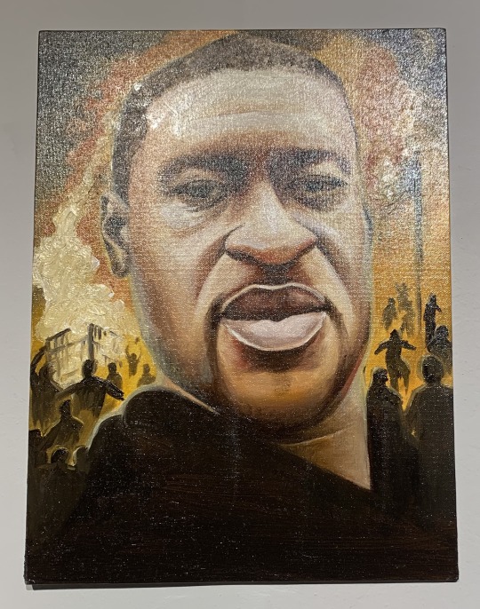
During the Friday excursion of the neighborhood, I began my day at the Bridgeport Art Center. The art center is located on 35th Street, at 1200 West 35th Street, in the central manufacturing district; once the location for the Spiegel Catalog warehouse. Established in 2001, the Bridgeport Art Center is focused to continuously serve as a resource for creative minds, and to be the beacon for the innovating Chicago art scene (Bridgeport Art Center, 2020). The art center is home to numerous artists, designers, and working professionals. Incredibly, I was fortunate enough and one of the first to attend the art center on the same day of its 4th Floor Gallery opening reception. The gallery’s newest theme entitled ‘Where’s the Revolution,’ is an exhibition featuring political art expressing varying points of view of global politics and social justice standards (Bridgeport Art Center, 2020). The exhibits displayed depict themes current to modern issues in America. At the forefront of the exhibits were criticisms of the current presidency, as well as the extremely salient movement of Black Lives Matter. In one work the artist depicts the final words of George Floyd, “I can’t breathe.” The artistic piece utilizes yarn on canvas to depict the final words, in the artist’s own words, “lives holding by a thread.” Many of the artistic works also present an underlying theme of police brutality targeted against racial minorities.
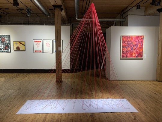
I Can’t Breathe by Pinar Aral
Floyd by Victoria Goite
Although the 4th Floor Gallery was fascinating to explore and witness, I was able to meet and discuss with internationally acclaimed Italian sculptor, Virginio Ferrari. During my walkthrough of the 4th Floor Gallery I was confronted by a waste management consultant who worked in the building. He thought it would be an advantageous opportunity to meet and have a dialogue with Ferrari. I agreed to his opportunity and he escorted me to Ferrari’s work space in the basement of the building.
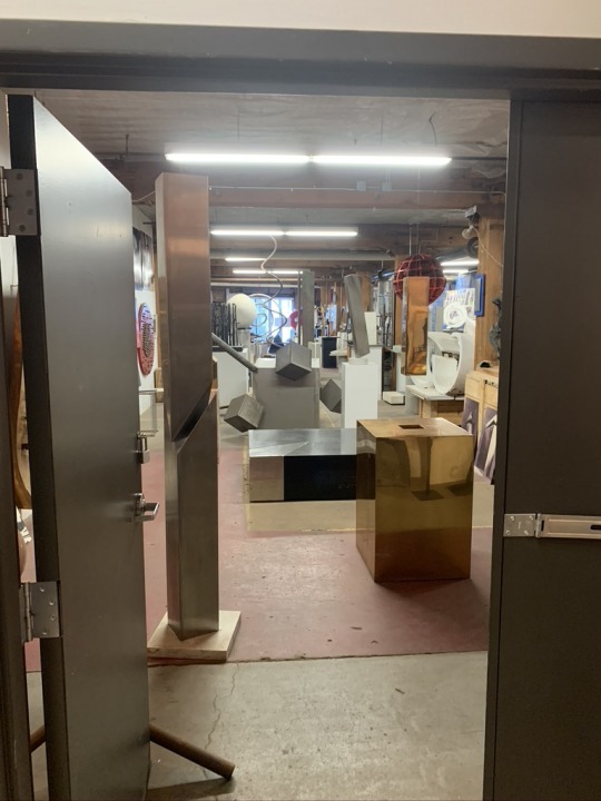
Virginio Ferrari’s Workshop in Bridgeport Art Center
I had the ability to have a personal tour of Ferrari’s shop by the man himself. He discussed his life story and beginnings of his artistic career. Mentored by his father and grandfather in the trade of stone cutting, Ferrari learned respect for the craft, and has continued his family’s legacy since. Ferrari is an immigrant of Italy who migrated to Chicago in the 1960s. After his migration to Chicago, Ferrari would serve for one decade as the Assistant Professor of Art and Sculptor in Residence, at the prestigious University of Chicago (Ferrari, 2020). Ferrari has thirty monumental pieces alone in Chicago, and other works can be witnessed all over the world, with sculptures located in Europe, Asia, and throughout the continental United States. Some of his most notable works found in Chicago include the Being Born exhibition near the Ohio Feeder Ramp in Riverside North, as well as the controversial exhibit Dialogo, which casts a shadow annually on May Day that depicts the Communist sickle and hammer (Ferrari, 2020). Even at the age of eighty-three year, Ferrari is still active with his craftsmanship, constantly creating new sculptures in his Bridgeport workspace.
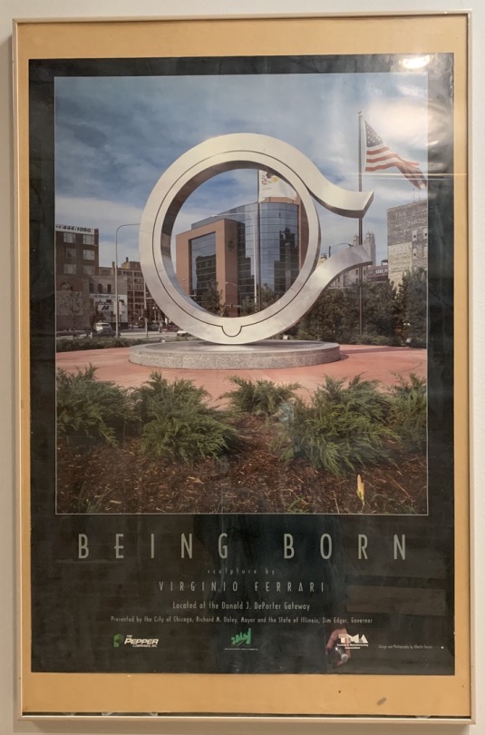
Being Born by Virginio Ferrari
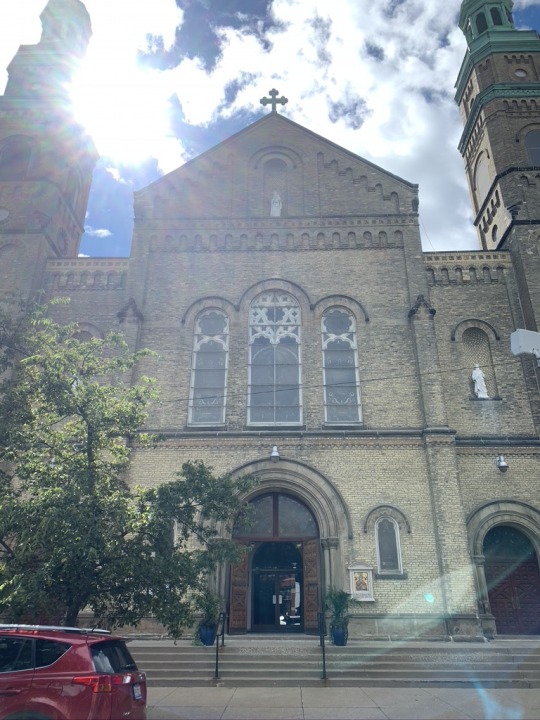
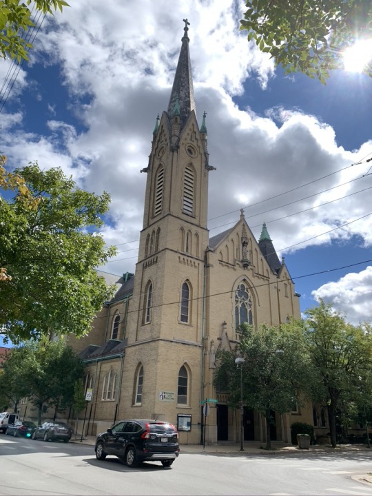
Although the opportunity to meet the world renowned sculptor, Virginio Ferrari, was incredibly exciting, there was still more to see of the neighborhood. After my visit to the Bridgeport Art Center, I continued my morning walkthrough of Bridgeport by viewing a couple of churches located in near proximity. The first church I was able to visit was the Roman Catholic Church of St. Mary of Perpetual Help. This church has been standing in Bridgeport since 1882 (St. Mary of Perpetual Help Church, 2020). Its establishment was influenced by the growing Polish immigrant population in the area. It served as a community home for these Polish immigrants, and still serves today as the parish for the Catholic girl high school, De La Salle Institute. The building itself is magnificent with elaborate towers and a colossal dome, with intricate detailing found all over the building.
St. Mary of Perpetual Help Church, 1039 West 32nd Street
After my walk by the St. Mary Church, I was able to see the Monastery of the Holy Cross. This monastery was established a century later than the previous parish discussed, in 1988. Although the monastery was established in 1988, the building in which the monastery resides was once the home of a Polish parish, the Immaculate Conception Church (Monastery of the Holy Cross, 2020). The Monastery of the Holy Cross was founded by three missionary priests who sought out to combat the challenges of evangelization in the modern world (Monastery of the Holy Cross, 2020). The priest's mission was evangelization of the modern ‘desert’ of the city, which faces issues of violence, alienation, and spiritual poverty (Monastery of the Holy Cross, 2020). To comment on the building, the monastery is found at the location of the former Immaculate Conception church. The building although simple in design, with a only singular vertical turret attached, is known for its beauty. The sheer height of the tower was quite remarkable to witness in person.
Monastery of the Holy Cross, 3111 South Aberdeen Street
As the end of my trip neared, I decided to visit one of the local parks in the neighborhood. Located at 2700 South Halsted Street, in the heart of the Bridgeport neighborhood, I was able to visit the Palmisano Park and Quarry. Prior to the park, the area was most well known for the Stearns’ Quarry, in which massive amounts of limestone were extracted from the earth. This twenty-six acre site offers a bountiful amount of activities for visitors to enjoy. The park includes a fishing pond, interpretive wetlands, preserved quarry walls, trails, an athletic field, a running track, and over one and a half miles of walking trails (Chicago Park District, 2020). The park itself was gorgeous to walk around. It provided an incredible view of the Chicago skyline, and most notably preserves the land of the neighborhood. This park was very refreshing to experience. Being in the city can be overwhelming with the lack of green space, but the Palmisano Park adds a much needed escape from the urban environment. It is hard to imagine, but the natural landscape of Chicago is composed of a marsh, and this is made very apparent through the park. Tall grasses and a pond were just two obvious features of the park displaying marsh characteristics. It was a pleasant surprise to discover this park. Even though I have been living in the area for two years now, it was exciting to explore a new green space in close relation to my university.
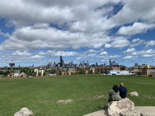
View of Chicago Skyline from Palmisano Park
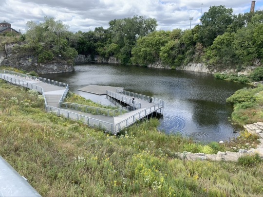
Fishing Pond at Palmisano Park
Looking back on my trip to Bridgeport, the neighborhood is a multicultural enclave in a new emerging art scene. The oldest neighborhood of the city of Chicago surprised me with its numerous cultural identities. Initially founded by mainly Irish immigrants, the neighborhood has transformed its identity through the inclusion of other minorities. Immigrants from Mexico and Asia have built a new home for themselves in the neighborhood. The city in its past has been considered segregated, but this was not the impression I felt during my visit to the neighborhood. Bridgeport if anything, is a hub of acceptance and integration, consisting of many varying cultural and ethnic backgrounds. Made apparent by the religious institutions littered around the neighborhood, Bridgeport is a melting pot of culture, history, and art. Some individuals debate whether or not Bridgeport is the next ‘hipster’ neighborhood. I think that Bridgeport has the potential to grow to be this hipster hub. With two art centers already established in the neighborhood, along with a collection of unique restaurants, and public spaces for neighborhood residents to enjoy; Bridgeport, although the oldest neighborhood, is still transforming and staying up-to-date with cultural and social activities. I would recommend any visitor of Chicago to explore Bridgeport. As illustrated previously throughout this post, the neighborhood is compiled of varying commercial, religious, residential, and public spaces. Also home to the Chicago White Sox, the neighborhood offers plenty of activities for visitors to expierence. Bridgeport is a neighborhood of detailed and extensive history, but it is still transforming to serve the needs of its people.
Sources
Bloom, J. G. (2012). Images of America: Bridgeport. Retrieved September 25,2020, from https://www.google.com/books/edition/Bridgeport/JpjWCdLKyzEC?hl=en
Bridgeport Art Center. (2020). 4th Floor Gallery. Retrieved September 25, 2020, from https://bridgeportart.com/
Ferrari, M. G. (2020, September 02). Virginio Ferrari Foundation. Retrieved September 25, 2020, from https://virginioferrarifoundation.org/
St. Mary of Perpetual Help Church. (2020). History. Retrieved September 25, 2020, from http://www.stmaryofperpetualhelp.com/p/history-of-our-church.html
Monastery of the Holy Cross. (2020). Our History. Retrieved September 25, 2020, from https://chicagomonk.org/about-us/our-history/
Chicago Park District. (2020). Palmisano Park. Retrieved September 25, 2020, from https://www.chicagoparkdistrict.com/parks-facilities/palmisano-henry-park
Statistical Atlas. (2020). Race and Ethnicity in Bridgeport, Chicago, Illinois. Retrieved September 25, 2020 from https://statisticalatlas.com/neighborhood/Illinois/Chicago/Bridgeport/Race-and-Ethnicity
Photos
All of the photos illustrated throughout the blog were taken by me except for the following images:
Map of Bridgeport:
https://www.google.com/books/edition/Bridgeport/JpjWCdLKyzEC?hl=en
1 note
·
View note
Photo

Yangon is the site that has the highest concentration of colonial buildings in the world. Therefore, I would like to focus on one of the architecture there, where many of structures now stand in disrepair.
I’m quite interested with the writing by Paul Philippot “Restoration from the Perspective of the Humanities” that he talks about the conservation of the “Particular Value”. Basically, it is more about sacrificing some part of the memories to conserve other context, historical and present environment.
But yes, what should we sacrifice or what is advisable to restore? Redefining the monument from a larger perspective is not a new idea. Therefore careful observation implying both a gathering of information and choice of values are required. Which restoring or doing something new need to be comprehensive with the present context to apply with what they need.
So as Yangon is the site that has the highest concentration of colonial buildings in the world. I would like to focus on one of the architecture there, where many of structures now stand in disrepair. Which location that I selected is located at the heart of downtown Yangon.
The Former Tourist Burma Building is the selected building that sits next to many historical, religious buildings and monuments. As you can see this is quite a good location that people who visit here can see all nearby important architecture. Also, it is located near amenity like 26th street Fresh market, Indian Market, ChinaTown and so on.

Also nearby the site is Sule Pagoda that sits in the center of the road. This Pagoda was built almost 2,600 years ago to enshrine the hair of Buddha. The following map is from 1760 when the pagoda was surround around the river. In 1910, showing that Sule Pagoda is a nucleus of the grid pattern for the Yangon city. Or basically, this is an urban grid designed by the British in 1850 that Sule Pagoda is the center of this Urban grid.

Also the Former Tourist Burma Building has passed through many events and changed the program many times. It was completed in 1905 by British Architects named Thomas Swales, whose architecture was owned by Indian Merchant. In 1908, the building transformed to be the first Burmese department store. While in 1920, the program was changed to be a film hub or studio. Unfortunately, the building was damaged by a severe bomb during WWII. Also the government uses the building as a distribution centre. After the suffering damage, the building was given to the Trade Corporation and occupied as a Tourist Burma Office. Then in 1992, it was established as a Ministry of Hotels and Tourism till 2005 when the Ministry moved to Nay Pyi Taw.In November of 2017, the renovation of the Former Tourist Burma Building began. Which it undertook by Turquoise Mountain and Yangon Heritage Trust. It pretty much just conserves and retains the historic features and the atmosphere of the building.
This is a plan of the building which mainly contain 3 floor plus the mezzanine and roof.

Here is an elevation that Show little bit of the contrast of the building.


Moving to Design concept, Basically this is an timeline of the change in time of this place, where pagoda was built over 2,600 years old. The British create a grid by indicating the Pagoda as the center of the urban grid. Then the pagoda was surrounded with the junk of buildings which obscured the original form of the pagoda. Therefore I would like to preserve the value of the pagoda in the original form and take it back to try to see the building more an isolation. So I want to bring all of the programs in this construction to the former tourist Burma Building and turn it to be a place that tourists can visit as you can see in the pictures, they are located directly to each other. It also have a great view.

And here is some case study that related to what I want to redesign my site, which is a justice building. It has kept the original appearance that presents itself as a premise to a more general composition. While the new appearance gives the new perspective and senses to the building. It has an extremely different form from the existing. Which these 2 majors elements give the project functional. Also the 2 element have respectful relationship between modernity and historical building (including facade). And this is an elevation shown of the selected site and case study building. Which pretty much have the similar ideas of what I wanted to restore and change. To enrich Yangon by a new landmark that still respects the image inscribed in the collective memory of some part of the historical facade.

And this is my concept design where I would like to start demolishing the staircase and circular construction that surround the pagoda. Which all of the usage will directly move to this building and almost all of the programs are for the Sule Pagoda like all the store and fortune telling will move here and I will pretty much add more locker room, exhibition area and information center in it. All I want is to get back to the original view of the Pagoda. Then instead of using the staircase, I would like to dig and crave the link below the road to the pagoda, since it is more respectful to stay below the Buddha, get rid of the bad memories of the flyover staircase (where the soldier stand over with the gunshot during the mob) and also get more new experience walking through it. Then craft out the floor and make this whole part as a circular walkway that people can experience the view within the building.... but all in all, I still want to keep the facade of the former tourist Burma Building.

0 notes
Text
BETWEEN THE BRIDGES
A few years ago I did a feature on Manhattan between the Manhattan and Brooklyn Bridges (I call it BEMBO), but as always, there’s more to see and there are details I missed. This time of year I also begin to scout areas that would make decent Forgotten NY tours in the spring and summer. BEMBO is a curious area, full of crannies and nooks of interest. Had I been writing Forgotten New York in the 1960s, there would have been a lot more to talk about, as maybe half of this neighborhood has been razed to build housing projects, schools, and the NYPD headquarters. I was able to show some of these lost streets in a FNY post in January 2019.
Getting off the F train at East Broadway at Canal (Straus Square) I meandered west. I discussed the Mesivtha Tiferes Jerusalem Yeshiva just the other day, so I won’t repeat myself here; it’s a handsome building in buff and brown brick, and has a venerable history.
East Broadway, looking west, looking toward the Manhattan Bridge overpass, and behind it, the Municipal Building and Woolworth Building, which from this vantage look like twin spires of the same building. In the left background is #4 World Trade Center and on the right, of course, is #1 World Trade Center. In the foreground left is the relatively new 109 East Broadway, the site of a devastating fire in 2010. The building exhibits the latest trend in residential architecture, featuring a boxy design with colored metal panels and flat windows. Why do so many new apartment buildings looks like this? They’re the cheapest to build.
In FNY’s Comments section, and remarks from friends on facebook, twitter and in person, many dismiss new architecture outright, saying nothing built today matches the past. I judge each building on its merits, and part of me is happy to live in a dynamic city that can accommodate new designs. I like a city that has both a Jenga tower and a St. Patrick’s Cathedral.
Until the beginning of the 20th Century, East Broadway was known as Chatham Street, for William Pitt, Earl of Chatham (1708-1778) who was the English Prime Minister during the time the colonies were agitating for independence, but before the Revolutionary War. He opposed the Stamp Act, but also opposed outright independence, but promoted compromise that ultimately proved untenable. Many USA locales are named for him including Pittsfield, MA and Pittsburgh, PA, as well as Chatham Square, East Broadway at the Bowery.
No good way to get a picture of the Knickerbocker Post Office, 128 East Broadway near Pitt Street because of … all the mail trucks parked in front of it.
Washington Irving (1783-1859), who met his namesake George Washington while a young boy, was popular both in the States and in Europe for his essays and fiction, and was the creator of Ichabod Crane, Rip van Winkle, and the tricornered Father Knickerbocker, NYC’s mascot. “Knickerbocker,” which is fun to say, refers to NYC’s early Dutch settlers and appears frequently in NYC lore, including its NBA basketball team.
The Sung Tak Buddhist Association at 13 Pike Street was once the Pike Street Synagogue, a Classic Revival building from 1903 that housed the Congregation Sons of Israel Kalwarie, Poland. Entertainer Eddie Cantor was bar mitzvahed here in 1905. The tripartite façade, which has an arched portico reached by twin lateral staircases, reflects Romanesque and classical features.
Looking north on Pike Street, which was named for explorer Zebulon Pike, soldier and explorer (1779-1813) of Pike’s Peak fame. Along with Allen Street, which begins a block north, the road was widened several decades ago and now sports a modern bicycle path. You can walk in a straight line all the way from here to the Harlem River, as Pike becomes Allen and Allen becomes 1st Avenue.
Turning left on Market Street, I encountered one of the oldest churches in Manhattan at Henry Street, the old Market Street Reformed Church, which was built in 1819. The windows are made up of multiple panels—35 over 35 over 35. This is now the First Chinese Presbyterian Church, which shared the building with the Sea and Land Church until 1972.
The brick and stone Georgian-Gothic church was constructed two centuries ago as the Market Street reformed Church on land owned by Henry Rutgers, and after changing congregations a few times over the years, it’s now the First Chinese Presbyterian Church. It’s in the top five oldest extant church buildings in New York City, the oldest being St. Paul’s Chapel on Broadway and Vesey St.
Every time I’m in the area, I check on Mechanics Alley, which runs on the west side of the Manhattan Bridge anchorage for 2 blocks between Madison and Henry Streets. Though it has obtained a more narrow sense, the word “mechanic” originally meant an artisan, builder or craftsman, not necessarily a machinist. No property fronts on the narrow lane, but trucks nonetheless employ it despite its narrowness to avoid heavier traffic on streets like Market.
I did a pretty comprehensive post on Mechanics Alley and its history a few years ago in FNY.
Market Street contains a number of historic and classic buildings along its short stretch between East Broadway and South Street. Here’s #40 market on the corner of Madison, which still has its original entrance woodwork as well as the street identification brownstone plaques. The Market Street side looks as if it has had some ad hoc repairs done sometime in the past.
375 Pearl Street, otherwise known as the Verizon Building, a.k.a. the Intergate Center, looms at the west end of Monroe Street. Many call it the ugliest building in Manhattan, though I’ve seen far worse. In 2016 it was renovated and received a new bank of windows.
This shabby brick building at 51 Market St. was constructed in 1824 by merchant William Clark. Its original elegant doorway, with Ionic columns, a fanlight and ornamentation, has survived nearly two centuries. A close look at the basement windows shows them to be surrounded with brownstone work with squiggly lines, known in the architecture world as “Gibbs surrounds.” A fourth floor, which studiously copied the original three, was added after the Civil War. The stoop and railings, however, are not original as they were replaced in 2010. The door is festooned with graffiti, and though the house has Landmark status, its condition appears deteriorated.
Amid the Chinese-language signs on Market and Madison, at the edge of Chinatown, is this neon sign for a long-gone liquor store.
At #47 Market Street is a venerable brick building that conveniently lists the date of construction, 1886, at the roofline.
Faces peer out from the front of this Madison Street apartment. Many of these buildings, and those on paralleling Monroe and Henry Streets, were built in the 1880s, when such embellishments were found on just about every building, commercial or residential.
The undulating exterior of #8 Spruce Street, officially New York By Gehry, named for architect Frank Gehry, is the architect’s signature NYC building. Like it or not, it’s instantly recognizable from all over lower Manhattan. After its completion in 2011, it was NYC’s tallest residential building for a couple of years, but has since been surpassed by buildings like 432 Park.
The Roman Catholic parish of St. Joseph (“San Giuseppe”) was established by the Missionaries of St. Charles, an order of priests and brothers founded by Blessed John Baptist Scalabrini in 1887 to serve the needs of Italian immigrants. The present church was designed by Matthew W. Del Gaudio and opened in 1924. Shortly after the founding of the parish, the Scalabrinians were joined by the Apostles of the Sacred Heart of Jesus, who helped open St. Joseph School in 1926.
Today, St. Joseph Church is a national parish designated as an Italian and Chinese parish. The parish continues the mission of the Church of St. Joachim, located at 26 Roosevelt Street until the 1960s, which was founded by the Missionaries of St. Charles who arrived in New York City in 1889. Immediately after, Mother Cabrini was welcomed by the same church as she arrived in the United States. American Guild of Organists, NYC Chapter
Speaking of the Scalabrinians, in January 2018 I visited their former bailiwick, St. Charles Seminary in Todt Hill, Staten Island, which had been the estate of architect Ernest Flagg.
Catherine Street classics, near Madison Street.
Madison and Oliver Streets. Al Smith (1873-1944), a four-time NYS governor and failed presidential candidate, was born on Oliver, a still-existing street between the Brooklyn and Manhattan Bridges, neither of which had opened when he was born. He was one of NYC’s most popular politicians in history.
On a walk up the Lower East Side in January 2013, I encountered an anachronistic building that I either hadn’t seen or hadn’t noticed before, on Madison Street a few doors away from St. James Place. It’s a tiny two-story dormered building — however, it’s not too small that it doesn’t have two separate doors and two separate house numbers, 47 and 49. I’ve always been curious about anachronisms and survivors, being something of an anachronism myself, so I looked it up. Expecting a difficult or fruitless search, I found something by the historian David Freeland, who rote about it in 2009 in the now-defunct New York Press:
For years the house has been something of a mystery, but one glimpse into its colorful history is revealed through a small advertisement from the Spirit of the Times newspaper, as reprinted in the Boston Herald of March 2, 1853: “Rat Killing, and other sports, every Monday evening. A good supply of rats kept constantly on hand for gentlemen wishing to try their dogs, with the use of the pit gratis, at J. Marriott’s Sportsman’s Hall, 49 Madison Street.”
Rat baiting, setting rats against rats, or dogs against rats, was a popular betting sport in the 19th Century in the days before the ASPCA. The building where another former rat baiting establishment was run by Kit Burns, the Captain Joseph Rose House, still stands at 273 Water Street in the Seaport area.
Freeland goes on:
By the late 1850s, the house at 49 Madison Street had been taken over by English-born Harry Jennings, who ran it as a combination saloon and rat-fighting pit until his conviction on a robbery charge sent him to prison in Massachusetts. But later, after returning to New York, Jennings settled into a kind of respectability, winning fame as a dog trainer and, eventually, the city’s leading rat exterminator. By the time of his death, in 1891, Jennings’ clients included Delmonico’s Restaurant and such luxury hotels as Gilsey House and the original Plaza.
Apparently, there’s a comeback in everybody.
The dark shadows of January intrude on the intersection of James and Madison Streets, one of the few intersections in NYC where both street names make up a US President’s first and second name. I’m sure it wasn’t planned that way, though.
We can see St. James Church, the second oldest building associated with the Roman Catholic Church in NYC. (Old St. Patrick’s Cathedral, Mott and Prince Streets, built in 1810, precedes it.) The fieldstone, Doric-columned Greek Revival building was begun in 1835 and completed in 1837; and though it is thought to be a design of famed architect Minard Lefever, there is no evidence to support the claim. A domed cupola above the sanctuary was removed decades ago. This was the boyhood parish of Al Smith, and New Bowery, which connects Pearl Street and Chatham Square, was renamed for it in 1947.
The massive Chatham Green development, located along St. James Place between Madison Street and Chatham Square, opened in 1960, was one of the projects that eliminated much of the ancient street grid in lower Manhattan, as well as the last remnants of the Five Points slum. But on those streets were located dark, noisome and cold tenements, and Chatham Green was constructed by the City in an effort to make middle-income peoples’ lives better. As we know, that effort has had mixed results.
Chatham Green went condo several years ago, with hefty prices, somewhat belying its original purposes.
This triangular-shaped building comes to a point at St. James Place and Madison Street. As I have noted, St. lames Place, laid out in the mid-1850s, was originally called New Bowery, but the designation must have been fluid at one time, as the chiseled street sign on the building simply has “Bowery.”
One Police Plaza, along Madison Street and Park Row (both closed to regular traffic) opened in 1973, is the headquarters of the NY Police Department; it took over from the old domed HQ, now a condo conversion at Centre and Broome Streets. It was designed by Gruzen and Partners in a Brutalist style and sits near the assorted city and state court buildings at Foley Square.
The NYC Municipal Building was constructed in 1914 from plans by McKim, Mead & White; it now houses only a fraction of the city offices that oversee the functioning of the metropolis. Particularly attractive is the row of freestanding columns, the extensive sculpture work and the lofty colonnaded tower topped by Adolph Weinman’s 25-fot high gilt statue of Civic Fame.
I have happy memories of the building since on October 23, 2006 I spent a half hour with Brian Lehrer on WNYC-radio discussing Forgotten NY the Book, and temporarily, my Amazon sales jumped into the 500s (by contrast, 12 years later, I’m in the 300,000s usually).
The sculptures on the north arch include allegorical representations of Progress, Civic Duty, Guidance, Executive Power, Civic Pride and Prudence. Between the windows on the second floor are symbols of various city departments. Note the collection of plaques, among which is the “triple X” emblem of Amsterdam, Holland. Chambers Street once passed through the building and once went all the way to Chatham Square but the NYC Police Dept complex was built over its path in the 1960s. —Gerard Wolfe
The fortress-like, business-themed Murray Bergtraum High School was built at Madison Street and Robert F. Wagner Senior Place, adjacent to Brooklyn Bridge off-ramps, in 1976. It’s named for a former president of the NYC Board of Ed., between 1969 and 1971. Noted alumni include entertainers John Leguizamo and Damon Wayans.
Rose Street, once chockablock with tenements, is a curved street running under the Brooklyn Bridge connecting Gold and Madison Streets. It was named for late 18th-early 19th Century merchant and distiller Captain Joseph Rose, whose house still stands nearby on Water Street. I discussed Rose Street at length on this FNY page.
Though I continued into the Seaport area, it’s a busy weekend and I’ll wrap things up for now.
Please help contribute to a new Forgotten NY website
Check out the ForgottenBook, take a look at the gift shop, and as always, “comment…as you see fit.”
1/6/19
Source: http://forgotten-ny.com/2019/01/between-the-bridges/
0 notes
Text
Response to Text Investigatio
Looking into the facts surrounding the abandoned area on the corner of Taranaki and Frederick Street, I have been able to conduct a text based investigation as to what was there, what is there, and what could be there.
Quite by chance I’ve learnt a lot about the old Chinatown of Wellington through my text research. The early settlers of from China came to Wellington just after an Earthquake raised the land in 1855. Between the 70s and 80s the land which is now the empty lot grew into a buzzing hub for the Chinese people in New Zealand and became what was known as Chinatown. Chinatown mainly consisted of Hainings Street, and a bit of Frederick Street and in 1905 one of the only two Chinese mission halls was built. Although there was a large rise in activity and markets in the Chinatown district, not everyone was happy about the way Wellington was looking. The Chinese community in Wellington was not treaty very kindly and were heavily policed, yet nothing out of the ordinary was ever found. On top of the heavy policing, there was often general racism towards the Chinese people, as well as multiple stories spread in the streets, saying that the Chinese would kidnap children and boil them. The worst case of racism towards the Chinese community was on the 24th of September 1905 when Lionel Terry shot dead Mr Joe Kum Young with a revolver before turning himself in. His reasoning for this was that he believed to be ridding the country of ‘yellow peril’. This resulted in Terry getting the death penalty, but skimming past it and being declared schizophrenic and spending the rest of his days in a mental institution.
The hall itself is quite interesting too. When it was first build in 1905, it served as the Chinese mission hall and was later welcomed / joined by the Anglican church. Nowadays the hall is the only remaining artefact from the Chinatown era which really captures the essence of the area, rundown as it may be. It’s noteworthy that the structure of the hall is still standing and remains unchanged to this day, other than some slight reinforcements a could of years ago. Though it is still standing, the hall has nearly completely run its course as it now sits isolated in the empty lot with broken windows and graffitied walls. Keeping the cultural heritage in mind, I think that it would be a great waste of time and history if we were to destroy the hall; instead I think that there is a way to engage multiple communities in the space.
As well as looking in to the history of the area itself, I have looked into some other places around the work that have refurbished rundown sights into something new and creative for the public to enjoy. Two notable examples of this would be firstly in the neighbourhood of the La Floresta in Brazil where an old building (standing at nearly 5000 square feet) sat abandoned for years and was not touched due to its cultural heritage. This was until in 2013 a group of artists and the Association of Cultural Villa Flores turned it into a vibrant space that has since been used to hold multiple art exhibitions, and live performances. The second example of this is the church of Santa Barbara that has been refurbished into an indoor skatepark. The church is personally the most interesting to me as it shows that the original structure can be reused as well as adding on a personal touch to it. The church was built in 1912 but had since been left to deteriorate. Until in 2007, Redbull and some crowdfunding pooled together and restructured the building, and turned it into an indoor skatepark. The skatepark was then decorated and painted by a well known Madrid street artist. This kind of thing is a great opportunity for something new and exciting like an attraction to be built, while still keeping the original structure and heritage of the building. It also provides a chance for local artists to help work on the project.
But what can I actually do about the space? The biggest issue with my investigation is the ownership of the land. Because the area has been left abandoned and unused, the council can’t really do too much with it. I have emailed them to find out what can be done and unfortunately they are not allowed to disclose the information as to what was there before, who owns the land, nor their plans for it. However I am able to start a petition that can then be taken to have a meeting with 5 representatives of the Wellington Council if I’m really serious about it.
This variety of information that I have collecting has helped me understand more about the history of the space, and what has happened to it. It has also given me an insight as to what we can do about it and how do go about it. One of the main things that I have taken from this research is that in no circumstances should we fully dismantle the old Chinese Mission Hall. The hall is one of the only remaining artefacts of Chinatown, and knowing this has slightly furthered my aims in this investigation to not only making the space a nicer place, but reestablishing that historic Chinese connection. I think that the space is full of potential and could be quickly turned around into something that can be enjoyed by the public on a range of levels, either walking through, running past or driving past on your way to work.
0 notes
Text
Notebook 1: Jajangmyeon
Jessica Gweon
A16
For my Zine, I decided to write about jajangmyeon, a Korean noodle dish that originated from China. In the late 1800's, there was a settlement of Chinese military in port city of Incheon due to the First Sino-Japanese War over the control of the Korean peninsula. In 1905, Chinese merchants who accompanied the military and settled in Incheon, introduced zhajiangmian, a salty black bean noodle dish, to Korea. Koreans took this dish, made it sweeter to better fit the palates of Koreans, and made it into a national sensation. The dish became popular in the 1950's and 1960's during the Korean War, when jajangmyeon was one of the few dishes that could be made with the wheat rations given by the U.S. It became one of the cheapest, easily accessible, and most delivered foods in Korea. There is even a national holiday, Black Day on April 14, where singles get together and eat jajangmyeon.
Although the Chinese have made an important contribution to Korean cuisine and have been present in Korea since the last century, they are still marginalized peoples. In the 1960's and 1970's, the president of South Korea at the time, Park Chung-hee, controlled Chinese businesses and Chinese landownership in Korea . Those who did not flee to other countries such as Taiwan ended up managing Chinese restaurants due to the popularity of jajangmyeon specifically. The dish aided in allowing Chinese migrants the right to exist in Korea, while also allowing poor Koreans to survive. Today, a Chinatown is located in the city of Incheon, yet there are only a couple hundred Chinese residents. There have also been a number of Koreans who have opened jajangmyeon restaurants in China. With the help of Korean dramas, Korean-style jajangmyeon has been increasing in popularity, especially compared to the original, Chinese zhajiangmian.
Jajangmyeon, which originated in China and was modified in Korea, is an important part of Korean-American culture. Even in the United States, jajangmyeon is still one of the cheaper Korean dishes, making it extremely affordable for working-class immigrants. When I was growing up in Los Angeles in the early 2000s, my parents would always bring jajangmyeon home as take out or order it whenever we would go out to eat at Korean restaurants. Whether we ordered five orders of the dish, or shared one order, or boiled up a few instant packets from the store, jajangmyeon was something that was always eaten as a family. It was one of the foods that I remember eating frequently while growing up, yet it was never made in the home. For this project, I asked my parents why this was the case, why we ate jajangmyeon so frequently yet we never cooked it ourselves. When my parents were growing up in Korea, jajangmyeon was one of the only dishes they were able to afford at restaurants or in stores. It was a dish that everyone was able to eat, was easily accessible, and was well-loved by Koreans. Not only was it cheap to buy, but it was also cheap and easy to make. When my parents first immigrated to the United States until recently, jajangmyeon was again one of the few Korean dishes they were able to afford in restaurants and in stores. However, the ingredients, specifically the black bean paste and the meat, were difficult to obtain due to the cost. Eating a bowl of jajangmyeon with the family or other Koreans helped my parents become more comfortable in a new country and keep them tied to their Korean identity during a time of national identity confusion. Presently, my family does not eat jajangmyeon as often, but when we do it's a dish that everyone at the table ends up ordering. It is an important symbol of cultural exchange between Korea and China, while also being a significant part of Korean-American culture.
Sources:
http://www.nytimes.com/2007/03/02/world/asia/02korea.html
http://www.koreatimes.co.kr/www/news/nation/2009/04/117_43382.html
https://koreancultureblog.com/2015/05/07/koreanized-chinese-cuisine-jajangmyeon-black-bean-sauce-noodles/
0 notes
Last Seen Blogs

barrisforpresident
BARRIS BOYS!!!

dayanadhblog-blog
SI VAS A SOÑAR SUEÑA EN GRANDE

shiny-jr
Shiny-Jr.

goglobalonline-blog
Untitled
