#Fujjifilm X100V
Photo

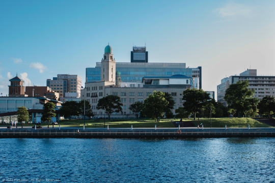
Blue City Skyline
This shot of the Minatomirai waterfront district features Yokohama’s most well-known high-rise towers and hotel: Landmark Tower (left), Queen’s Tower A and B (center), The Yokohama Bay Hotel Tokyu (center-left), and the InterContinental Yokohama Grand hotel (right), which “evokes the image of a white sail against the blue sea.”
When overseas cruise ships visiting Japan arrive in the Port of Yokohama, this is the skyline passengers will see first as they disembark from the ship.
Fujifilm X100V (23 mm)
ISO 160 for 1/640 sec. at ƒ/4.0
Classic Chrome film simulation
#横浜港#横浜#みなとみらい#都市景観写真#ストリートスナップ#pix4japan#classic chrome#Fujjifilm X100V#Fujifilm#Japan#Yokohama#Minatomirai#myyokohama#Port of Yokohama#cityscape photography#urbanscape photography
87 notes
·
View notes
Photo

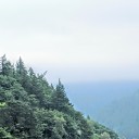
Trail to Grass-Covered Mountain Peak
Location: Mt. Daruma, Shizuoka Prefecture, Japan
Timestamp: 14:20 January 31, 2023
The winding Nishi-Izu Skyline toll road is a popular route for both motor and cycling enthusiasts. At the second curve, you can see the Asebigahara Parking Lot and the trail to Mt. Kodaruma, which if you keep heading north, will take you to the peak of Mt. Kinkan.
This shot was taken on my way up to the peak of Mt. Daruma (approx. 982 m/3,221 ft), which is mostly covered in kuma bamboo grass (kumazasa/Sasa veitchii). The trailhead is at the bottom of the frame near the highway.
Fujifilm X100V (23 mm) with 5% diffusion filter
ISO 2500 for 1/250 sec. at ƒ/2.0
Classic Chrome film simulation
#風景写真#静岡県#伊豆半島#熊笹#達磨山#pix4japan#Fujjifilm X100V#Fujifilm#Shizuoka Prefecture#Izu Peninsula#Mt. Daruma#landscape photography
14 notes
·
View notes
Video
youtube
Minami-Izu, Shizuoka Prefecture, Japan
Honzei Port and Yumigahama Cove in the town of Minami-Izu are located on the southern tip of the Izu Peninsula (Shizuoka Prefecture) about 185 km (115 mi) southwest of Tokyo.
Yumigahama Cove is accessible by taking the bullet train from Tokyo to Atami, and then taking the Ito Line to Izukyu-Shimoda Station from where you can take a commuter bus to the Kyukamura bus stop. From there you have a 13-minute walk to the beach.
Traveling with a border collie means that public transportation is not an option for me. Driving to Yumigahama Cove takes about 4 hours using both the Tomei Expressway and local highways depending on traffic and time of day.
Since I typically leave home after midnight, I am able to shave about 30 minutes off of travel time and am able to arrive at my destination, find a vacant parking space, and take a short nap until sunrise.
Honzei Port (本瀬港):
https://goo.gl/maps/1DUBC7ANdPxPk6AU9
Ouji Shrine (王子神社):
https://goo.gl/maps/isHRMgDpF9Qm7Lgp7
Yumigahama Cove (弓ヶ浜):
https://goo.gl/maps/eQHBJoGdDqtgzama
#youtube#静岡県#南伊豆#弓ヶ浜#ボーダーコリー#海景写真#海景#GoPro Hero 11#fujjifilm x100v#Pentax#pix4japan#Shizuoka Prefecture#Izu Peninsula#seascape photography#border collie#Japan
8 notes
·
View notes
Photo
Historical Customs House on Waterfront
Off-center to the left is the historical Yokohama Customs Building. Rebuilt in 1934 after the Great Kanto Earthquake of 1923, among the various inspirations applied to design elements seen throughout the building include the dome, which was inspired by and Islamic mosque, and various elements for the rest building, especially the interior, were inspired by Western-European Romanesque styles. The historical customs building with its dome is known as the “Queen” and the square shaped tower to the left is the “King.”
Fujifilm X100V (23 mm)
ISO 160 for 1/340 sec. at ƒ/2.8
Classic Chrome v2 film simulation
#キングの塔#クイーンの塔#横浜#横浜港#古典主義#横浜税関#ストリートスナップ#pix4japan#Classic Chrome#Fujjifilm X100V#Fujifilm#Japan#Yokohama#Yokohama Customs#cityscape photography#urbanscape photography#myyokohama#Port of Yokohama#architectural photography#urban photography#street photography
8 notes
·
View notes
Photo

Store Window Featuring a String Puppet Witch
“Green Thumb,” a local shop on the famous Motomachi shopping street in Yokohama, Japan, which was established in 1985 with the catchline “Witches and Herbs.”
According to the store’s website, witches were not scary things in ancient Europe, but were more like pharmacists who held a wealth of knowledge of the natural world and especially the health benefits of herbs.
I initially thought the carvings were dried-apple head dolls!
Fujifilm X100V (23 mm at ƒ/2)
ISO 320 for 1/160 sec.
Classic Negative film simulation
#横浜#元町#ストリートスナップ#マリオネット#富士フィルム#pix4japan#Classic Negative#Fujjifilm X100V#Fujijilm#Japan#Yokohama#Motomoachi#string puppet#witch#street photography
9 notes
·
View notes
Last Seen Blogs

boxingcleverrr
The Unbearable Awkwardness Of Being

belanor
"not all who wander are lost"

mansplains
↪️yaoiplug

soulstead-sanctuary
Sisterhood is our religion