#Glacier Meadow Loop Trail
Photo
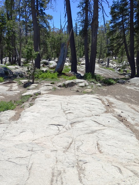


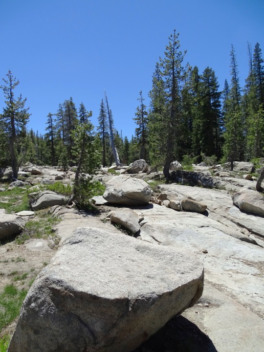

The first group of rescuers reached the Donner Party on February 19, 1847.
#Donner Party#rescuers#19 February 1847#anniversary#US history#USA#Donner Pass#Sierra Nevada#Glacier Meadow Loop Trail#California#travel#vacation#original photography#tourist attraction#landmark#pond#mountains#forest#flora#landscape#countryside#Donner Party Plaque#pine#fir#tree
30 notes
·
View notes
Text
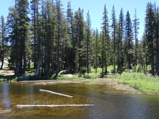
Sometimes hiking is about the destination. Getting to a lake or a fire lookout. Sometimes hiking can be about the journey. What you see and experience along the trail. The Silver Forest Trail out of Sunrise is a journey trail.

The trailhead can be found near the Sunrise Visitor Center, in the southern corner of the parking lot. Starting from there, you stroll down the dirt trail to your first vista. A wonderful view over the rock wall of Mount Rainier awaits. Framed by trees, you get a great view of the Emmons Glacier and a small, bright blue moraine lake. From your first view, the trail turns east. It wanders along through groves of trees and meadows. Depending on the time of year, you might see the colors of summer wildflowers or autumn leaves on the shrubs and small plants.

The Silver Forest trail takes it name from when a wildfire swept through this area years ago. As some trees died, they remained standing but their bark fell off leaving the trunk wood which silvered from the weather. You can still see some silver trees today.

About 1 mile each way (2 miles roundtrip), this trail is relatively easy with only 150 feet of elevation change. The Silver Forest trail packs one last surprise for hikers. This is an out and back trail, not a loop, so when you turn around to hike back to the parking lot, you’re treated to views of the mountain. In and out of the trees, our mountain appears almost so close you could reach out and touch it. Have you hiked the Silver Forest trail at Sunrise? Which was your favorite view along the trail? ~ams

Please remember the road to Sunrise is only open seasonally.For more information about Sunrise and its trail, https://www.nps.gov/mora/planyourvisit/sunrise.htm . The Sunrise trails and map handout can be found here https://www.nps.gov/mora/planyourvisit/upload/2016-Sunrise-Area-Trails_access.pdf
NPS/Spillane Photo. Start of the Silver Forest trail going from the parking lot to the first scenic vista. July, 2020. NPS/Spillane Photo. View from scenic vista of Mount Rainier, Emmons Glacier, and small lake. July, 2020. NPS/Spillane Photo. Wildflowers (lupine, lousewort, daisy) in meadow along the trail. July, 2020. NPS/Spillane Photo. View looking back up the trail (towards parking lot) through meadow and trees with Mount Rainier in background. July, 2020.
#encuentra tu parque#find your park#trails#hiking#mount rainier#mount rainier national park#wildflowers
27 notes
·
View notes
Text
I’m going to give a detailed account of our trip. If you’re not interested in reading about our five week tent excursion, please feel free to skip.
Days 1 & 2:
We started with a tour of Winona State University in Minnesota, and then camped two nights at Whitewater State Park. My college roommate/best friend lives in the Twin Cities, and some of her kids also did the college tour, and they camped with us the first night which was a great way to kick off our adventure.
Days 3 & 4:
We camped at Palisades State Park in eastern South Dakota. That park is so beautiful. We went to a ranger talk about fireflies which was given by a college student and well done. We also did a Charlie Brown movie night sponsored by the park where we indulged in $.25 popsicles and popcorn.
Days 5-7:
We drove to Custer State Park. We did the obligatory stops at the Corn Palace and Wall Drug along the way. At Custer we hiked Sylvan Lake and Cathedral Spires. We also drove the wildlife loop and saw bison, big horned sheep, and lots of prairie dogs.
Days 8 & 9:
We stayed at the KOA in Cody, WY. It’s not very impressive for tent campers. There is ZERO shelter, and we nearly lost our tent in a storm. Thankfully, it stayed intact, but we spent a couple of hours bailing out water. However, it does have a pool which was a hit with the kids. They also offer a free pancake breakfast which was a nice reprieve from cooking.
While in Cody we went to the rodeo (kids loved it), ate really good pizza at a local place, and it is where Ms. 6 took a fall and hurt her knee to the point that she will need an MRI in the next week or two.
Days 10 & 11:
We drove into Yellowstone National Park via the west entrance. The drive from Cody was phenomenal! We saw bison and had lunch next to Yellowstone Lake. Last year we didn’t see the lake at all except for driving by it. I really wanted to spend some time on it this year. Lunch was perfect!
The next day we went back to the lake and did a short hike. Then we went to Old Faithful. I took Ms. 6 to the clinic there to have her knee looked at. We watched Old Faithful erupt, and we got to see the visitor center there and see the Old Faithful Inn which is beautiful. I had not been to either of those spots before despite watching Old Faithful erupt before. We also saw elk on our drive back to our campsite.
We stayed at Grant Campground.
Days 12-17:
We drove out of the west entrance of Yellowstone and headed north to Glacier National Park. We camped at Apgar there. On the drive, we saw several moose and my first bear! I was thrilled!
Apgar Campground is basically located on Lake McDonald which was cold! Every body of water at Glacier was cold! It was a long drive to get there so that first night we basically set up camp, ate dinner, and went to bed.
We hiked Rocky Point Trail, Trail of the Cedars, and Avalanche Lake. We also went to Polebridge and ate the most amazing huckleberry bear claws at The Mercantile. We drove to Bowman Lake and hiked a meadow trail at Polebridge.
The Going to the Sun Road opened while we were there (it was mid-July), and I’m so glad we got to experience driving it. The day we drove it, it was cold and rainy so a good day for it as we would not have been hiking. The views were incredible. We saw our first and only mountain goat on the trip, and two bears! They still had snow in areas, and although it took us the bulk of the day, we still had fun (kids were done though).
Two cousins of mine (siblings but they live in different states from each other and us) were in the park at the same time along with my uncle, and we happened upon them while they were eating dinner one night which was super fun because we did not have cell service to make a connection while there.
Our last night in the area we stayed at the KOA in West Glacier. That KOA is pretty nice, but the day was cold and rainy so we couldn’t take advantage of the pool. We mostly did laundry. I ended up getting a UTI. Ugh. So grateful we had some antibiotics on hand.
Day 18:
We drove to Spokane, WA and stayed in a hotel. The Hampton Inn has never felt so luxurious! Showers and beds for everyone! They had a pool too and we loved spending some time in there before bed.
Day 19:
We drove to Olympia, WA and celebrated DD’s birthday. We did Starbucks, the three older kids saw a movie, and then we went to Chipotle for lunch before heading to Olympic National Park.
Days 20-25:
Olympic National Park. I’m convinced I’d never survive in the PNW. It was 59-61 degrees every day and socked in with clouds most of the time we were there. I knew it would be cold, but didn’t expect it to be that cold (weather app said it would be about ten degrees warmer for the week). The wildlife was amazing, but we actually left one day early because we just couldn’t handle being cold, wet, and without sunshine.
Day 26:
Drove to Cannon Beach! That was one of my favorite afternoons! 70, sunny, tide was going out. I wish we would have caught the sunset. We had seafood for dinner along the shore before driving into Portland for the night. I got to see Mt Hood from a distance.
Day 27:
Portland! We went to the original Voodoo Doughnuts! Then we met up with my cousin who lives there, his wife, and my aunt and uncle who were visiting from NY. We ended up going to the Washington County Fair. My uncle treated all the kids to wristbands for the rides and an epic afternoon was had.
Day 28:
We drove to Sisters, OR. We pitched our tent in the backyard of a longtime friend of DH’s who graciously fed all of us too.
Day 29:
We drove to Idaho Falls, ID and camped at the KOA which backs up to a farm field. We really just needed a place to sleep. This fit the bill.
Days 30-37:
We drove to Grand Tetons National Park. We camped at Colter Bay. I really like it there because they have showers and laundry and that’s nice when you have kids and just need to clean up.
Colter Bay is on Jackson Lake which is part of the charm, but I was super disappointed to see that the lake is very low due to Idaho’s water needs. The marina at the campground wasn’t open due to such low water levels.
Grand Tetons was one of my favorite parts of the trip because we did some excellent hiking and saw so much wildlife which I was not expecting. We hiked Moose Pond, Phelps Lake (and DH did the cliff dive after hiking out to it), Taggart Lake, Bradley Lake, and Jackson Lake. We also did the scenic drive to Signal Mountain.
Days 38 & 39:
Allllll of the driving home.
31 notes
·
View notes
Text
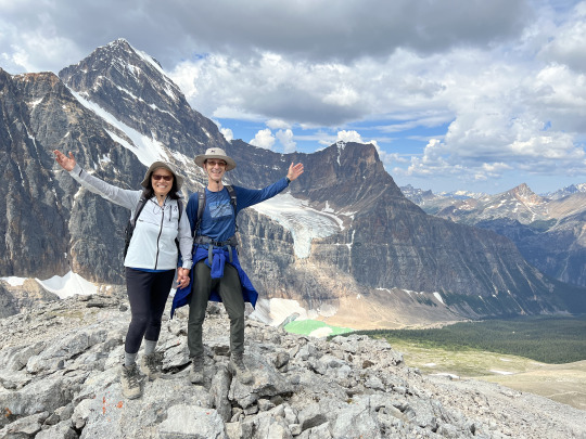
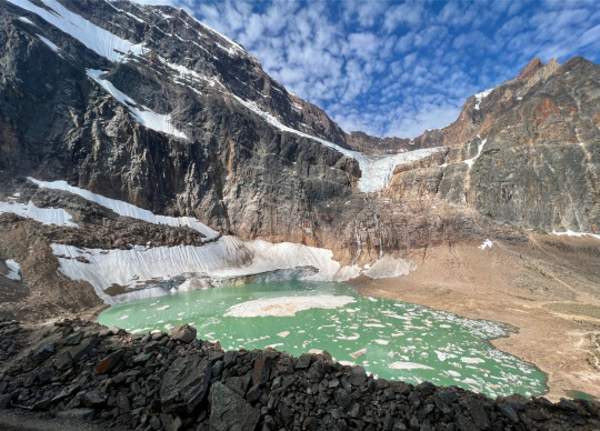
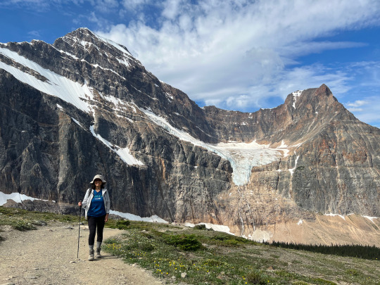
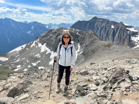
East Ridge Summit (via Edith Cavell Meadows Trail)
Date: 07/30/2022
Country: Canada
Region: Jasper National Park, Alberta
Endpoint: East Ridge Summit: 2571 m.
Trail type: In-and-out, with loop portion in the middle
Length: 8.5 miles
Elevation gain: 2,800 ft
Trailhead: Edith Cavell Meadows Parking Lot
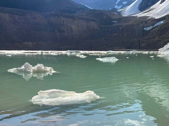
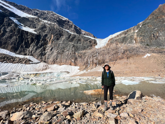
We started the hike early, as we knew it is a very popular destination. The two oversize parking lots at the trailhead, though almost empty when we arrived there at 8:30 am, gave a good indication of what was to come. We started vigorously, dashing up the paved sightseeing trail called “Glacier Walk” to a nice viewpoint, overlooking Mount Cavell and Cavell Pond—a jade colored glacier lake with melting chunks of glacier debris dotting its surface like vanilla ice cream in a float.
Before us rose the daunting north face of Mount Edith Cavell (named after a WWI nurse who was executed by the Germans for aiding Allied soldiers escape from German occupied Belgium—a strange choice of naming for a beautiful mountain, notwithstanding the gallant lady’s obvious merits). Seen from a distance, the mountain leans at a nautical tilt, with parallel bands of rock and snow giving the impression of a sinking ship; but up close, the view is of an imposing and doubtlessly hard-to-climb peak.
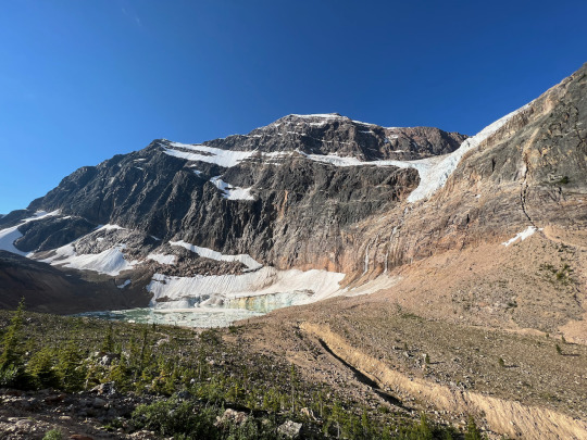
We were practically alone when we arrived at the shores of the glacier lake (incongruously called Cavell “Pond”), and we snapped a good number of pictures there, for the sight was lovely.
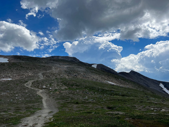
Then, just ahead of the first wave of sightseers, we headed up the hiking trail toward Edith Cavell Meadows.
Spring had arrived late in the Canadian Rockies this year, and only 2-3 weeks earlier, snow fields were still impeding hiking progress here. But now, a heatwave was in full swing, with temperatures soaring above 90 even in the mountains (part of a continental—or even north-hemispheric—drought phase), and this dispatched of the snow cover in a short time, allowing for the explosive growth of the flora waiting underneath. Now, the lower-lying meadows were in full bloom with Indian Paintbrush, Heather, Daisies and plenty of other pretty flowers vying for prominence.
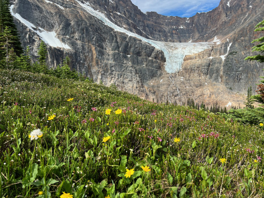
But only a narrow band of altitude displayed this floral abundance, and once we gained more altitude, the flowers were still in wait. What was definitely out in full force were the bugs! Although we had slathered on a generous amount of repellent at the outset of our hike, we were soon attacked relentlessly, forcing us to double down on the repellent stuff, putting on a second layer of an even stronger product to keep the pest at bay. It got slightly better after we entered the area above the tree-line, although even here the flies and mosquitoes were still active. But just turning around to behold the glorious sight of Edith Cavell North Face, Angel Glacier sticking its tongue out at us, and the ice-dotted jade pond receding further and further below us--all this made the insectile inconvenience pale by comparison.
At a fork where the trail divides to form a loop, we chose the steeper (left) branch, reserving the longer, more gradual portion for our descent. About an hour and a half into the hike, we left the meadows behind and entered upon a stony ridge that led up to the end of the official trail. Along this stretch, we had good, muscle-straining fun, as we balanced on the edge of the comb, enjoying ever more spectacular views. We reached the “official” end of the trail at 11 am, and now we had the option of pushing on to reach East Ridge Summit, following a clearly visible, though less frequented trail made by people who simply were not satisfied to turn around before the highest point on the ridge was reached. It looked steep but doable, so we decided to make a go for it.
The extension was really worth it. A half hour later, just before entering the last stretch of loose scree, rocks, and an occasional snow patch, a large, flat stone to the side invited us to settle down for a picnic. Here, we ate our lunch sandwiches and replenished our fluid levels while taking in the sweeping vista.
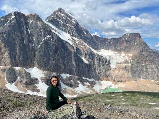
Thus refreshed, we tackled the steepest portion of the ascent, making frequent zig-zag turns and holding each other’s hands for support. It is my favorite kind of territory—challenging to the point of making the heart race, yet without being outright dangerous. At noon sharp we arrived on the top, three hours after starting out. The scenery was wonderful in every direction, and we took a good number of pictures here.
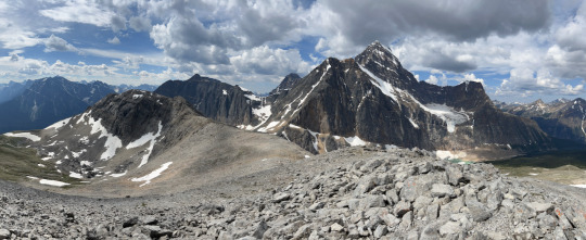
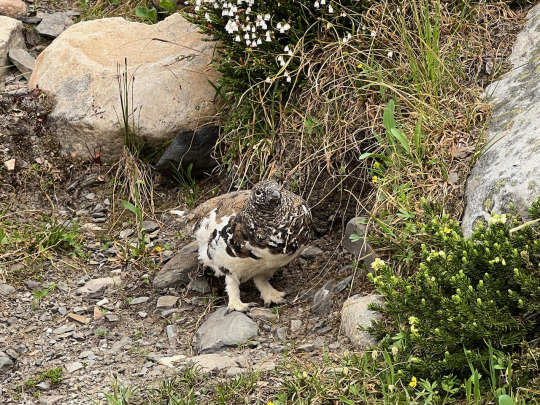
But we didn’t spend much time on the summit, as it started to look like the weather was about to turn. A few pretty impressive thunderheads were developing, and we wanted to stay ahead of the development. Rain did eventually come down, but by then we were already on the lower section of the return trail, approaching the valley bottom. We had taken the more gradual segment of the loop going down, and we enjoyed another burst of flower power along the meadows there. A Ptarmigan by the side of the trail was picking at the floral buds without paying us any mind.
At 2:30 pm, we were back at the parking lot, now bustling with hundreds of visitors. The early bird gets the quiet moments.
2 notes
·
View notes
Text
Exploring Nature's Masterpieces: The Best Hikes in Oregon

Oregon, known for its breathtaking landscapes and diverse terrain, offers some of the most spectacular hiking experiences in the United States. From coastal cliffs and cascading waterfalls to towering mountains and ancient forests, the Beaver State boasts a wealth of natural beauty waiting to be explored. Here are some of the best hikes in Oregon that promise unforgettable adventures for outdoor enthusiasts of all levels.
Multnomah Falls Loop Trail: Located in the Columbia River Gorge National Scenic Area, the Multnomah Falls Loop Trail is one of Oregon's most iconic hikes. This easy-to-moderate trail takes hikers on a scenic journey through lush forestland to the base of the stunning Multnomah Falls, the second-highest waterfall in the United States. With its picturesque views and accessibility, the Multnomah Falls Loop Trail is a must-visit for nature lovers and photographers alike.
Smith Rock State Park: Situated in central Oregon near the town of Bend, Smith Rock State Park offers some of the best hiking and rock climbing opportunities in the Pacific Northwest. The park's network of trails ranges from easy strolls along the Crooked River to challenging hikes that lead to panoramic viewpoints overlooking the rugged terrain. Highlights include the Misery Ridge Trail, which offers stunning views of the Cascade Mountains, and the Canyon Trail, which meanders along the scenic Crooked River.
Columbia River Gorge: Eagle Creek Trail: For a more challenging adventure, the Eagle Creek Trail in the Columbia River Gorge is a must-visit. This moderate-to-difficult hike takes hikers on a journey through lush old-growth forest, past towering cliffs, and alongside sparkling waterfalls. Highlights include Punch Bowl Falls, a picturesque waterfall surrounded by moss-covered rocks, and Tunnel Falls, where hikers can walk behind the cascading water for a truly immersive experience.
Cape Lookout Trail: Located on the scenic Oregon Coast, the Cape Lookout Trail offers breathtaking views of the Pacific Ocean and the rugged coastline below. This moderate hike takes hikers through dense coastal forest to the edge of a dramatic cliff, where they can spot whales, seabirds, and other marine life. With its stunning vistas and proximity to the beach, the Cape Lookout Trail is a favorite among hikers and nature enthusiasts.
Mount Hood: Timberline Trail: For experienced hikers seeking a challenge, the Timberline Trail around Mount Hood is a bucket-list adventure. This strenuous, multi-day hike circumnavigates Oregon's tallest peak, offering unparalleled views of glaciers, alpine meadows, and volcanic landscapes along the way. Highlights include the iconic Timberline Lodge, the shimmering waters of Mirror Lake, and the majestic beauty of the Sandy River Canyon.
Opal Creek Wilderness: Opal Pool Trail: Tucked away in the lush forests of the Opal Creek Wilderness, the Opal Pool Trail is a hidden gem waiting to be discovered. This moderate hike follows the crystal-clear waters of Opal Creek through ancient groves of Douglas fir and hemlock trees, leading hikers to a pristine swimming hole surrounded by towering cliffs and lush vegetation. With its serene beauty and tranquil atmosphere, the Opal Pool Trail is a peaceful retreat from the hustle and bustle of everyday life.
In conclusion, Oregon offers some of the most spectacular hiking experiences in the United States, from cascading waterfalls and rugged coastlines to towering mountains and ancient forests. Whether you're seeking an easy stroll or a challenging adventure, the Beaver State has something to offer for hikers of all levels and interests. So lace up your boots, hit the trail, and prepare to be amazed by the natural beauty of Oregon's great outdoors
0 notes
Text
Malham Cove Walk
Yesterday we were supposed to take the Settle - Carlisle train up and back, but when we got to the Settle train station we found that the rains the day before had washed out the track and no trains were running. They didn't know how long it would be, but a track washout is not a quick fix, so we canceled and left. (Nice station though.)

We drove to Ingleton to check out a local pottery shop located under one of the railroad viaducts.

A quick stop for coffee at the Goat Gap Cafe. There really is a place named Goat Gap. It looks like the cafe is the only thing there BUT Goat Gap is on the Ordinance Survey. It's a really nice very modern cafe too.

Then back to the hotel, for a cheese lunch with the cheese I'd bought the day before for the train trip.
Then I left Cathie there and drove to Malham for a walk. The trail there is a 4.5-mile loop to a waterfall, Janet's Foss, a little canyon, Gordale Scar, and then up to the top of Malham Cove.
It was cool and cloudy but a nice day by Yorkshire standards.
The trail starts with a rustic bridge, but then a very nice well paved or maintained surface as far as Gordale Scar.


With the rain the day before the stream and waterfall were running nicely.


I'm never sure whether a quick exposure that freezes the water in place or a long exposure that blurs it is best and end up taking both.

From the side I like the long exposure.

Then the trail went along the stream up into the scar.


It quickly ends at a series of waterfalls and possibly a scramble up.

But I am not up for a scramble and I need to get back to the hotel, pick up Cathie, and get to our dinner reservation, so no diversions.
Then the maintained trail ends and just a worn path to the top of the cove.

But there are good views across the green meadows and rock walls.


The top of the cove is a large weathered limestone slab at the cliff edge.


This area was covered with glaciers and as they receded the cove was a massive waterfall. Eventually, the water worked its way down through the limestone, so it now runs out at the bottom of the cliff face.
The path back down is on the other side of that slab and there is no longer any semblance of a trail. When I get to the slab I can see just how weathered it is! The surface is very uneven and the cracks are large enough to easily drop a leg or two into. It really is uncomfortable walking, knowing how easily I could slip and break a leg. But I got across and then saw that some people had gone around the backside of a hill to avoid the slab.


I found the trail on the other side, which was a long stone staircase all the way down.


It's a good workout for the knees.
Then a quick look at the cove itself before hoofing it back to the car.

My Strava app said it was 5.5 miles, not 4.5, which explained why I was running late. So on solid flat ground, I hurried back and drove as quickly as reasonable on the one-lane roads back to pick up Cathie for dinner.
0 notes
Text
Six Top Hiking Routes in Washington
Some individuals know that Washington State provides world-class hiking trails. The routes traverse diverse landscapes, including rugged coastline on the western border, arid high desert terrain in the eastern regions, and multiple mountain ranges in between.
The Skyline Trail, a primary hiking route in the Paradise hiking zone of Mount Rainier National Park, consists of a 5.5-mile path heavily enjoyed during the summer season and revered for its breathtaking vistas of Washington's iconic peak, Mount Ranier. Individuals can access the trail from the historic Paradise Inn parking area and winds through expansive subalpine meadows. Skyline Trail offers remarkable scenery and serves as the starting point for many adventurers aiming to summit Mount Rainier.
Next, the Cascade Pass Trail is one of the most accessible routes in the remote expanse of North Cascades National Park. Accessing the trail requires a 23-mile drive on Cascade River Road from Highway 20 near Marblemount. Recognized as one of the premier hikes in the region, it covers relatively easy terrain and offers stunning vistas of the rugged mountain peaks and the glaciated valleys below. The seven-mile round-trip involves navigating several switchbacks, gaining nearly 2,000 feet in elevation along the way. The Sahale Arm Trail suits advanced hikers and extends from the Cascade Pass Trail. It features additional panoramic views of subalpine meadows and majestic mountains.
Goat Rocks Crest Trail is a highlight along the Pacific Crest Trail (PCT) in Washington. Spanning approximately 28 miles with over 2,000 feet of elevation gain, the hike typically requires at least one night of camping. Hikers should prepare for varying weather conditions and expect to travel rugged terrain that winds along an exposed ridgeline dotted with large boulders. The route offers breathtaking views of iconic Cascade peaks like Mount Rainier, Mount Adams, and Mount St. Helens.
Hoh River Trail sits on the northwest side of Olympic National Park and showcases the diverse landscapes of the Olympic Peninsula in Western Washington. The national park boasts rugged coastlines, snow-capped peaks of the Olympic Mountains, and a captivating rainforest. Stretching over 17 miles, the trail maintains a relatively flat terrain, and its width accommodates summer crowds. Permits are available for camping along the trail for backpackers seeking an overnight stay. As the trail ends, hikers reach breathtaking vistas of Blue Glacier and Mount Olympus.
The Wallace Falls Trail in Wallace Falls State Park is one of Washington's most famous hiking routes. Just an hour from Seattle, the popularity of the hike stems from its accessibility and breathtaking scenery. The 5.6-mile round-trip trail passes by nine distinct waterfalls along the Wallace River. Hikers should prepare for intermittent slippery conditions, particularly when navigating the rushing waters. With an elevation gain of 1,300 feet, the trail's steepest climbs occur between the middle and upper falls.
Lastly, located in the eastern part of Washington State, the Steamboat Rock Trail near Electric City in Steamboat Rock State Park covers six miles in a loop and has an elevation gain of 700 feet. This trail sits 800 feet above Banks Lake, a sprawling reservoir spanning 600 acres. A moderate climb is necessary to ascend this route. During springtime hikes, wildflowers adorn the trail and offer panoramic vistas of the surrounding landscape.
1 note
·
View note
Text
10 Eastern Washington Hikes for a Day Trip

Lace up your kicks, because it’s time to take a hike! Eastern Washington is home to scenic wildlife and landscapes that are best seen on foot traversing through steep inclines, alongside rivers, and winding through mountainous forests.
If you’re Places to Visit in Washington State area, your trip won’t be complete without these top day trip worthy Eastern Washington hikes. Check them out!
Enjoy All The Beauty That Washington Has To Offer With These Eastern Washington Hikes
Hoh Rainforest Trail
Don’t miss the Hoh Rainforest Trail in the Olympic National Park! The trail is home to Roosevelt elk, various species of cascading moss, and large trees that look like something out of a sci-fi movie. This 10.6-mile hike ascends 500 feet—perfect for first-time backpackers and adventurous nomads.
Horseshoe Basin
Trek through the great outdoors of the North Cascades on the Horseshoe Basin trail near the Canadian border. This trail is home to an abundance of wildlife, including bears, deer, and bighorn sheep. However keep in mind, that this 12-mile roundtrip day hike is not for the faint of heart.
Anderson And Watson Lakes
You haven’t seen the best of Eastern Washington’s hiking trails until you’ve journeyed to the Anderson and Watson Lakes. This relatively easy hike is perfect for families and inexperienced hikers. Along the six-mile trail are copious opportunities for breathtaking glimpses of mountain ranges, and of course sleek views of the glassy Anderson and Watson Lakes.
Spider Meadow And Phelps Basin
Strap on your day pack for this 13-mile hike across the Central Cascades. Spider Meadow and Phelps Basin is an arduous hike with rewarding views of the glorious Glacier Peak Wilderness. As a result, this hike will challenge even the most seasoned hikers as it ascends nearly 2000 feet.
Rialto Beach And Hole-In-The-Wall
Escape to the beach! Stroll the rocky shore of Rialto Beach to explore the seaside wildlife, including whales, sea lions, otters, and seabirds. In addition, the beach hike has spectacular views of James and Little James islands.
Bird Mountain Loop
Get away from the hustle and bustle at Bird Mountain! The Bird Mountain Loop is a 10-mile trek in the Mount Adams area. This intermediate level hike ascends 1,875 feet and reaches an elevation of 5,230 feet. Additionally, this winding hike through the South Cascades has several campsites perfect for an overnight stay.
Tolmie Peak Lookout
You won’t be able to get enough of the views at Tolmie Peak Lookout! This trail begins at the Mowich campground with immediate views of Mowich Lake. In addition, the hike reveals scenic views of Eunice Lake, Carbon River Valley, and Mount Rainer.
Tipsoo Lake-Naches Peak Loop
Pack up the family car for this easy day hike! Tipsoo Lake-Naches Peak Loop is an all-levels three-mile hike in Steven’s Canyon. Even more, this hike is short and flat, only gaining about 600 feet in elevation. In the peak months of August and September, visitors are treated with spectacular views of fields of wildflowers—perfect for an impromptu photo-op.
Quinault River-Pony Bridge-Enchanted Valley
Keep your eyes peeled in the Enchanted Valley! The Valley is home to deer, elk, black bears, woodpeckers and more! Because this lush area receives about 14 feet of rain each year, the wildlife and flora here grow in abundance.
Larch Lake
Larch Lake is a year-round destination that provides beautiful scenery! Visitors especially appreciate the beautiful green, red, and yellow colors of the autumn foliage. Hikers travel along the McCue Ridge to reveal an all-encompassing view of the crystal-like Larch Lake and Chiwaukum Lake.
Turn Your Day Trip Into A Weekend Affair!
Eastern Washington is home to a plethora of scenic hikes! However, to see it all, you might consider making your day trip into a weekend-long trip of nature hikes.
Experience all that Washington has to offer at the conveniently located Soap Lake Resort—a resort town located less than two hours away from Spokane. The resort sits on top of Soap Lake, a body of mineral waters with Healing Mud Treatments properties. Recuperate after a long day of hiking in Soap Lake to naturally improve blood circulation, or take a swim in the cooling water. Contact Soap Lake Resort at 509-246-0462 to book your stay at this luxurious resort.
#HealthandWellnessResort#BestSpaResortsinUSA#SpaResortAccommodation#WellnessSpaRetreat#RetreatVenuenearSeattle
1 note
·
View note
Text
Fifth Wheel Campgrounds with Breathtaking Views

Embarking on a journey with your fifth wheel camper offers a unique blend of adventure and comfort, allowing you to explore nature's wonders while enjoying the convenience of a home on wheels. One of the key aspects that can elevate your camping experience is the choice of campground. In this blog post, we will delve into some of the most stunning fifth wheel campgrounds that offer breathtaking views, promising an unforgettable getaway for avid campers.
1. Yellowstone National Park:
Topping the list of fifth wheel campgrounds with awe-inspiring views is Yellowstone National Park. Renowned for its geothermal wonders, wildlife, and expansive landscapes, Yellowstone provides an unparalleled camping experience. Choosing a fifth wheel campground within the park allows you to wake up to the sight of bubbling geysers, majestic waterfalls, and herds of roaming bison. Be sure to explore iconic attractions like Old Faithful and Grand Prismatic Spring while relishing the serenity of nature.
2. Glacier National Park:
For those seeking a mountainous escape, Glacier National Park in Montana is a prime destination. With its towering peaks, crystal-clear lakes, and abundant wildlife, this park offers a truly majestic backdrop for your fifth wheel camping adventure. Many campgrounds within the park provide easy access to scenic trails, allowing you to hike or bike while surrounded by breathtaking vistas of glaciers and alpine meadows.
3. Big Sur, California:
The rugged coastline of Big Sur, California, is another gem for fifth wheel campers in search of mesmerizing views. Campgrounds perched along the cliffs offer panoramic scenes of the Pacific Ocean meeting the dramatic cliffs. Sunset views along the California coast are unparalleled, providing an ideal setting for a peaceful evening at your fifth wheel campsite. Explore nearby attractions such as McWay Falls and Bixby Creek Bridge for an enriching coastal experience.
4. Zion National Park:
Utah's Zion National Park beckons with its towering red rock formations, slot canyons, and diverse ecosystems. Choosing a fifth wheel campground within or near the park allows you to wake up to the sheer magnificence of Zion's canyons and mesas. Take advantage of the park's extensive trail network, and embark on hikes that lead to viewpoints offering breathtaking panoramas of the Virgin River and surrounding red rock landscape.
5. Acadia National Park:
Nestled on the rugged coast of Maine, Acadia National Park offers a unique blend of coastal beauty and lush forests. Fifth wheel campgrounds within the park or nearby provide a comfortable base for exploring the granite peaks of Cadillac Mountain, the scenic loop road, and the serene Jordan Pond. Capture the essence of Acadia's diverse landscapes, from rocky shorelines to dense woodlands, all from the comfort of your fifth wheel camper.
Conclusion:
Choosing a fifth wheel campground with breathtaking views can transform a camping trip into a memorable adventure. Whether you prefer the geothermal wonders of Yellowstone, the mountainous landscapes of Glacier National Park, the coastal beauty of Big Sur, the red rock splendor of Zion, or the diverse charm of Acadia, each destination offers a unique and awe-inspiring experience for fifth wheel enthusiasts. So, pack your bags, hit the open road, and immerse yourself in the splendor of nature from the comfort of your fifth wheel camper.
0 notes
Text
Emerald Trails: The Allure of Hiking in Seattle
Seattle which is also known as The Emerald City, is renowned for its breathtaking natural beauty and the outdoor possibilities. Though many people associate the city with its famous skyline and bustling technology scenes, Seattle is also a paradise for outdoor enthusiasts as it has a myriad of hiking trails catering to a variety of skill levels and tastes. In this post, we'll guide you through the stunning hiking experience which await you in Seattle.

Seattle's hiker's paradise is an array of trails which wind through evergreen forests, meander through rugged coastlines, and rise to the top of stunning mountain peaks. One of the most famous and accessible places to hike can be found in one of them, the Olympic National Park, just a few hours' drive from downtown. There, you'll find diverse ecosystems, including temperate rainforests within the Hoh Rainforest to alpine meadows within Hurricane Ridge. There are a variety options of trails. But the Hoh River Trail as well as the Sol Duc Falls Trail is the best option for their awe-inspiring beauty.
If you're looking for a more challenging experience, Seattle is just a few steps away from the Cascade Range, which offers a variety of thrilling trails. The majestic Mount Si, located just about an hour's drive away from the city center, is a popular hike with people who live in the area. The hike to the top although strenuous, provides trekkers with breathtaking views of the surrounding valleys and mountains. It doesn't matter whether you're an experienced hiker or an aspiring one you can find trails in the Cascades that are suitable for all skill degree.
At the opposite end of the spectrum, Discovery Park, located within the city's limits, provides the tranquility of. Being the city's most expansive day hikes near seattle and boasts an array of trails that meander through forests, meadows and even along the beaches. There's the Loop Trail, a 2.8-mile traverse through the park showcases the diversity of the Pacific Northwest landscape without the necessity of a lengthy drive. The trail's easy accessibility and gentle terrain make it a perfect choice for a spontaneous nature escape or for a relaxing afternoon stroll.

Seattle is bordered by a number of islands each one with its distinctive charm and unique the opportunity to hike. Just a ferry ride from downtown, Bainbridge Island beckons with its Winslow Greenway Trail, offering breathtaking forested hikes and glimpses of majestic Mount Rainier across the water. Vashon Island is yet another undiscovered treasure with trails such as Maury Island Marine Park, in which you can walk along sandy shorelines with secluded beaches. These island getaways make for great day trips where you can experience the beauty and natural splendor in Puget Sound.
The article on hiking in Seattle is complete without mentioning the iconic Mount Rainier. Towering at 14,410 feet, this active volcano has become a symbol that represents our Pacific Northwest. In the Wonderland Trail, encircling the mountain, is an arduous trail that leads hikers through various landscapes including alpine meadows and dense forests. Although the entire circuit takes some time, short hikes like that of the Skyline Trail at Paradise provide a taste of the grandeur of Mount Rainier. The blooming wildflowers here during the summer months are a sight to behold, and the glaciers glistening with light are breathtaking.
1 note
·
View note
Text
3-Day Itinerary of Yosemite National Park, California

Nestled within the Sierra Nevada mountains of California, Yosemite National Park is a natural wonderland that draws visitors from around the globe with its breath-taking landscapes, towering granite cliffs, cascading waterfalls, and diverse ecosystems. A three-day adventure in Yosemite offers a perfect blend of iconic landmarks, outdoor activities, and opportunities to connect with nature. In this meticulously crafted itinerary, we will guide you through a memorable exploration of this stunning national park.
Day 1: Arrival and Valley Floor Exploration
Morning:
Arrive at Yosemite National Park and check into your chosen accommodation within the park or nearby. Start your day with a hearty breakfast to fuel your upcoming adventures.
Late Morning:
Head straight to Yosemite Valley, the heart of the park, where awe-inspiring vistas and iconic landmarks await. Begin your journey at Tunnel View, a famous overlook that offers a breathtaking panoramic view of El Capitan, Half Dome, and Bridalveil Fall. This is an ideal spot for capturing the essence of Yosemite in photographs.
Afternoon:
For a closer look at the park's iconic granite formations, hike the easy loop trail to Mirror Lake. The calm waters of the lake often reflect the surrounding cliffs, creating a picture-perfect scene. Enjoy a leisurely picnic by the lake before continuing your exploration.
Evening:
As the day winds down, head to the Yosemite Valley Visitor Center to learn about the park's natural and cultural history through informative exhibits. Afterward, catch the sunset at Sentinel Bridge, where the setting sun casts a warm glow on Half Dome, making for a truly mesmerizing sight.
Day 2: Waterfalls and High Country Adventures
Morning:
Begin your second day with an early start as you venture to Yosemite Falls, one of the tallest waterfalls in North America. Follow the Yosemite Falls Trail for an up-close experience of the falls' thundering beauty. The trail is divided into two parts: the Lower Yosemite Falls Trail, a short and easy walk suitable for all ages, and the more challenging Upper Yosemite Falls Trail, which rewards hikers with stunning vistas.
Afternoon:
Satisfy your appetite with a packed lunch and then embark on a scenic drive to Glacier Point. From this lofty vantage point, you'll enjoy sweeping views of Yosemite Valley, Half Dome, and the High Sierra peaks. For a more adventurous option, consider hiking the Four-Mile Trail, which leads to Glacier Point and offers a sense of accomplishment alongside stunning scenery.
Evening:
As the sun sets, return to Yosemite Valley and take a leisurely stroll along the Cook's Meadow Loop. This peaceful trail offers magnificent views of Half Dome and the surrounding meadows, making it an ideal place to unwind after an active day.
Day 3: High Sierra Hiking and Departure
Morning:
On your final day, rise early for an unforgettable high country adventure. Drive to Tuolumne Meadows, a subalpine meadowland that offers a striking contrast to the valley's landscapes. Lace up your hiking boots and set out on the Cathedral Lakes Trail. This moderately strenuous hike leads you to pristine alpine lakes and showcases the beauty of Yosemite's rugged backcountry.
Afternoon:
Enjoy a picnic lunch amid the tranquility of the high country before descending back to Tuolumne Meadows. On your return, stop by Olmsted Point for a unique perspective of the granite formations and Tenaya Lake, a serene alpine lake that's perfect for a refreshing swim during the warmer months.
Late Afternoon:
As your Yosemite journey comes to a close, take a moment to reflect on the memories you've created amidst nature's grandeur. Before leaving the park, explore the Tuolumne Grove of Giant Sequoias, home to towering ancient trees that will leave you in awe of their sheer size and beauty.
Evening:
Depart from Yosemite National Park with a heart full of memories and a camera filled with snapshots of the breathtaking landscapes you've witnessed. Whether it's the towering cliffs, cascading waterfalls, or serene meadows, Yosemite's beauty will stay with you long after you've left its hallowed grounds.
In conclusion, a 3 day itinerary in Yosemite National Park is a carefully curated journey through some of the most iconic and awe-inspiring natural landscapes in the world. From the majesty of Yosemite Valley to the tranquility of the high country, this itinerary encapsulates the essence of Yosemite's beauty and offers a perfect balance between adventure and relaxation. So, lace up your hiking boots, pack your camera, and get ready to embark on a remarkable journey through the captivating wonders of Yosemite National Park.
#3-Day Itinerary of Yosemite National Park#Itinerary of Yosemite National Park#Yosemite National Park
1 note
·
View note
Text


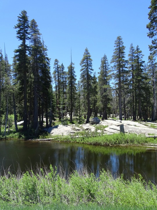
The first group of rescuers reached the Donner Party on February 19, 1847.
#Donner Party#rescuers#19 February 1847#anniversary#US history#USA#Donner Pass#Sierra Nevada#Glacier Meadow Loop Trail#California#travel#vacation#original photography#tourist attraction#landmark#pond#mountains#forest#flora#landscape#countryside#Donner Party Plaque#pine#fir#tree#trail#rocks#nature#flöra
3 notes
·
View notes
Text
[ad_1]
The Italian Alps are an enticing wonderland of jagged mountain scenery, lush alpine meadows, charming villages and glistening lakes. Here are 12 reasons why you should visit.
Covering a glorious mountain-filled arc sweeping across the top of the country, the Italian Alps are a scenic wonderland; an area of natural rugged beauty bursting with wonderful places to visit.
High up in the Italian mountains walk along high-alpine trails under razor-sharp vertical peaks; enjoy the tranquillity of emerald lakes glistening with a glacial glow; or savour the beauty of flower-filled alpine meadows.
At the lower altitudes unwind in beautiful Italian villages, sail on lakes lined with mansions, explore one of the most stylish cities in the world or sip wine in ancient surroundings.
There are so many places to visit in the Italian Alps and with hiking in summer, skiing in winter and plenty in between, there’s never a bad time to visit.
Here are 12 reasons for making the Italian Alps your next holiday destination.
Booking your trip via the links on this page (or on our book page) will earn us a small commission, at no extra cost to you. Thanks for your support – Paul & Mark.
IN THIS GUIDE
PLACES TO VISIT IN THE ITALIAN ALPS
WHERE ARE THE ITALIAN ALPS
The Italian Alps sweep in an arc from Monaco in the west to Trieste in the east, covering the northern tip of Italy.
They are made up of 3 main areas.
Western – The western side is the southern end of the high Alps: a dramatic playground of snowcapped mountains bordering France and Switzerland.
Central – The central section is the Italian Lakes where large lakes are framed by smaller hills and beautiful villages.
Eastern – The eastern section is the Italian Dolomites – jagged rocky peaks framed by lush alpine meadows.
The entire region of the Italian Alps is most easily accessible from Milan. But if you want to explore the eastern section, read our Dolomites Road trip guide accessible from Venice or Verona in the south or Innsbruck (Austria) in the north.
BEST PLACES TO VISIT IN THE ITALIAN ALPS
With glistening glacial lakes, flower-covered meadows, vibrant Italian towns and some of the best hiking in Italy, here are our suggestions for the top places to visit in the Italian Alps.
1 – TRE CIME DI LAVAREDO
There are few more dramatic mountains in the world than Tre Cime di Lavaredo. Three towering peaks, standing side by side, rise above a sea of boulders. Their near-vertical sides soaring to pointy peaks.
The most iconic views of these Italian mountains can only be seen hiking the Tre Cime loop. The paths are easy and the rewards are breathtaking. Various perfectly positioned rifugios offer a refreshing lager, a warm coffee and delicious Italian food throughout the hike. Tre Cime is a popular location for Dolomites photography and a perfect half-day out in the mountains.
TRE CIME HIGHLIGHTS
On the Tre Cime walk, make sure you stop off at Rifugio Locatelli (Dreizinnenhütte) for a coffee break with one of the best views in the Alps. More information is available in our guide to hiking Tre Cime.
2 – LAGO DI BRAIES
High up in the mountains and surrounded by jagged peaks, the Italian Alps are packed with stunning green-blue lakes. Best viewed in the early morning or late afternoon (when the wind is low), the shimmering dramatic alpine scenery is reflected in cool rippling water.
The dazzling colour is created from water that flows down the valleys carrying white particles collected from glaciers scraping against mountains.
Perhaps the most impressive of these lakes is Lago di Braies, the picture-perfect lake surrounded by the mighty rock face of Seekofel.
LAGO DI BRAIES HIGHLIGHTS
Leave the popular lake behind and visit the high alpine panorama of Prato Piazza. The views from the Monte Specie hike are simply stunning. All the information is in our guide to Lago di Braies.
3 – SECEDA RIDGELINE
The Puez-Odle mountains are like a mangled saw.
Bent and twisted pointy teeth form a jagged ridge of mountains. Nowhere else in the Italian Alps can you see such a mish-mash of soaring peaks fighting for your attention.
The best view of these jagged peaks is at the Seceda Ridgeline. Just a short stroll from the Furnes-Seceda cable car summit, a line of towering mountains form a spectacular photography location in the Italian Alps.
The grassy ridge with a narrow pathway leading up to the ridgeline is the perfect vantage point from which to take in the spectacle.
SECEDA HIGHLIGHTS
After collecting the stunning views of Seceda, take the easy downhill hike past several excellent rifugios to the town of St Christina. More information on how to do this walk is available in our top hikes in the Dolomites article.
4 – COMO
As the mountains of the Italian Alps drop into foothills and rushing rivers carry more and more water they finally form great lakes. The greatest and most beautiful of these is Lake Como. As the main centre on the lake, the town of Como is one of the best places to visit in the Italian Alps.
Stroll the old town complete with beautiful squares, charming churches and a host of interesting and quirky museums. The cathedral is one of the most impressive buildings in the city and the funicular to Brunate provides a staggeringly impressive view of the lakes.
COMO HIGHLIGHTS
Organise a boat trip to the beautiful village of Varenna, an idyllic Italian Alps village ideally situated on a promontory where the three legs of the Lake Como meet. Read more in our guide to hiring a boat on Lake Como.
5 – VAL DI FUNES
Instagram has brought fame to Val di Funes. This once quiet valley, tucked into the northern Italian mountains, now sees hundreds of travellers arrive to capture the iconic views of its two churches.
San Giovanni and Santa Maddalena sit in rolling hay meadows still farmed in the traditional fashion. But it’s not just the bucolic country scene that makes them special. Rising almost vertically behind them are the jagged peaks of the Puez-Odle massif.
Head here at sunrise or sunset and the churches with their imposing backdrops are beautifully lit. A photographer’s dream, an unforgettable vista and a favourite on our Instagram channel.
VAL DI FUNES HIGHLIGHTS
Take a sunset stroll along the beautiful Panoramaweg, an easy hiking path high above the valley floor. It provides one of the best vantage points to view the villages set amongst working farms. All the details for the hike are in our guide to Val di Funes.
6 – BELLAGIO
Is there anything more picture-perfect than an Italian town on a lake? And if so surely the most beautiful is Bellagio. Known as the pearl of Lake Como, it is strategically located where the junction of the Y shaped lake divides into two branches.
Peering out from its perch on the lakeshore, the facades of its golden villas, houses and churches reflect in the rippling blue waters.
Hidden behind these buildings lies a cute and intriguing village. Narrow laneways and twisty staircases conceal designer boutiques and local artisan shops selling the best silk in Europe. It’s one of the most beautiful towns in the Italian Alps.
BELLAGIO HIGHLIGHTS
There’s no better way to spend your time in Bellagio than by finding a seat by the lake and watching the sun go down with an Aperol Spritz in hand. Read more in our guide to visiting Lake Como.
7 – TRENTINO VALLEY
The Trentino valley is impressive. Fortresses peer over the steep-sided walls and little villages with cute churches perch on ledges or hide in crevasses. But the real joy of coming here is to sample the wine.
Vineyards spread all along the valley floor produce some of the finest wine in Italy. Surrounded by beautiful pastel-coloured buildings, little gardens provide the ideal setting to sample the local drop.
Our favourite is Alois Lageder in the village of Magré, a family vineyard run on biodynamic principles. They serve a delicious take on modern Italian cooking in a beautiful sunny courtyard.
Well worth a stop on any journey through the Italian mountains.
TRENTINO HIGHLIGHTS
After enjoying an afternoon of wine in the valley head into the town of Trento. The highlight is the Piazza Duomo backed by the Cattedrale di San Viglio. For more information see our complete Italian Dolomites itinerary.
8 – ALPE DI SIUSI
At 2,000m in altitude, visiting Alpe di Siusi, the largest high meadow in the Italian Alps is a breath-taking experience. Its swaying grasses, backed by some of the most magnificent mountains in Italy, are a lush green in spring and a golden brown in autumn.
The best way to see the area is by hiring an e-bike. That way – without too much huffing and puffing, and with zero emissions – you can see all the highlights of this Instagram friendly destination.
Fortunately, you don’t need to cycle up the meadow. A cable car carries you up 800m from the town of Ortisei. Even better, the free-wheeling journey all the way back down is an exhilarating ride.
ALPE DI SIUSI HIGHLIGHTS
Sunrise looking over the impressive views of Sassalungo (another excellent hike in the area is the Sassolungo-Langkofel circuit) with the alpine meadows in the foreground is an unforgettable experience in the Italian Alps.
9 – BRENTA DOLOMITES
The Italian Alps are the home of Via Ferrata, meaning ‘iron path’. Climbers are secured onto a steel cable that runs along near-vertical rock faces. Using the cables, plus iron rungs, pegs, carved steps and ladders, inexperienced climbers can make their way along narrow ledges and difficult peaks.
Vie ferrate have been linked together in the Brenta Dolomites creating extensive multi-day hiking tours with overnight stays in mountain refuges. It’s a nail-biting adrenaline-filled excursion. But even if that does not take your fancy, hiking in this rocky wonderland is excellent.
BRENTA DOLOMITES HIGHLIGHTS
On a hike in the Brenta Dolomites, stop for a break at Rifugio Tuckett. It’s one of the best-located huts in the Dolomites set among a rocky canyon and needle-shaped peaks. All the information is in our best hikes in the Dolomites guide.
10 – SASS PORDOI
The Italian Alps are not like the rest of the Alps. They are striking because of their unique shape and pale Dolomite rock. The rock was formed from fossilised coral reefs about 250 million years ago. When the African and European tectonic plates collided they were forced up into mountains.
The collision created a diverse array of shapes. And nowhere can you see this diversity better than from the top of the cable car that climbs from Passo Pordoi to Sass Pordoi. From here, observe table-top mountains, undulating grassy meadows, soaring pointy peaks and desolate moonscapes.
It’s the best of the Italian mountains in one breathtaking panorama.
SASS PORDOI HIGHLIGHTS
The views from Sass Pardoi are simply breathtaking, but the road there is a highlight as well. From Canazei take the road to Passo Pordoi via the 22 exhilarating hairpin bends. All the details are in our Dolomites itinerary.
11 – CERVINIA
The high-altitude ski resort of Cervinia has a network of over 160 kilometres of pistes, most of which have stunning views of the Matterhorn, just across the border in Switzerland. While the resort itself is not the most beautiful in Italy, the long runs and high-alpine views are hard to beat.
The already wonderful winter playground of Cervinia is due an impressive upgrade in 2021. A new cable car will link Cervinia with Klein Matterhorn, extending the ski season to a year-round activity. When it opens in the 2021/2022 season, it will be the highest cable car in the world with a climb of over 4000 metres. The 1-hour journey to Zermatt’s glacier paradise will extend Cervinia’s already long season to year-round skiing.
CERVINIA HIGHLIGHTS
The 8-kilometre red run that descends the 1,800 metres from Plateau Rosa is one of the most exhilarating ways to visit the Italian Alps.
12 – MILAN
Although just outside the Italian Alps, Milan is the gateway to the region and a wonderful place to visit.
With immaculate architecture, a greedy stash of some of the world’s best art, and a style matched by few cities, it’s well worth spending a few days in Milan on your way through to the Italian Alps.
Galleria Vittorio Emanuele II, the shopping centre giving all other shopping centres a bad name is an architectural masterpiece. Two glass-vaulted arcades meet in an octagon covering designer shops and high-end retailers. Go high-brow with opera at the exquisite Teatro alla Scala, or downplay it with an excellent slice of pizza on the street.
MILAN HIGHLIGHTS
Don’t miss sunset from the roof of the Duomo. As the colour fades from the streets of Milan, there are few better cityscapes in the world that are as spellbinding as this one.
THINGS TO DO IN THE DOLOMITES
Many of our 12 favourite places to visit are concentrated in the eastern section of the Italian Alps called the Dolomites. For more details read our complete guide to visiting the Italian Dolomites, but here are some highlights:
Hike the Tre Cime trail, one of the most interesting and achievable hikes in the Dolomites.
Visit Lago di Braies, a tranquil turquoise lake in an idyllic setting.
Take the gondola to Lagazuoi & Tofana for superb mountain views.
Soak up the atmosphere of hip alpine town, Cortina d’Ampezzo.
Capture the picture-perfect Val di Funes with the Instagram famous church.
Drive the winding passes on the Great Dolomites Road.
WE’D LOVE YOUR SUPPORT
If you found this guide useful, a small donation helps fund our work – Big thanks, Paul & Mark.
FOLLOW US ON INSTAGRAM
USE OUR RESOURCES PAGE
MAP – PLACES TO VISIT IN THE ITALIAN ALPS
We’ve collected all our favourite places to visit in the Italian Alps on our map. To save this map, click on the star to the right of the title. This will save the map to Your Places in Google Maps.
>>
How to use this map / Click on the top left of the map to display the list of locations, then click on the locations to display further information. Click on the top right corner of the map to open a larger version in a new tab or the star to save to your Google Maps.
THANKS FOR VISITING // WHERE NEXT?
A BIG THANK YOU
We’ve been providing free travel content on Anywhere We Roam since 2017. If you appreciate what we do, here are some ways you can support us.
Thank you!
Paul & Mark
FOLLOW US ON INSTAGRAM
USE OUR RESOURCES PAGE
[ad_2]
Source link
0 notes
Text
Must-See Attractions Along the Delhi-Leh-Manali-Srinagar Bike Route
One of the most popular and thrilling bike trips in India is the leh bike trip from manali. This bike ride covers some of the most spectacular landscapes in India and is an unforgettable experience.
The manali to leh bike trip distance covers 474 km, with a total journey time of around 12 hours. The route crosses four high mountain passes through the Himalayas, as well as several other scenic spots. The journey starts from Leh, the capital of Ladakh, which lies at an altitude of 3,524 m above sea level. From there, you will move westwards towards Manali over Turkwin La (4,906 m), Baralacha La (4,883 m), Lachung La (5,065 m) and Rohtang Pass (3,978 m).
Along this route you will get to witness some breathtaking views – from snow capped mountains to lush green meadows and gushing rivers. You’ll also get to experience traditional Ladakhi culture at each village along the way. Some famous attractions in this route include Rumtse Valley, Gata Loops and Suraj Tal Lake – all amazing places that should not be missed.
Apart from these beautiful sights and destinations that you will pass along a bike trip to leh , it is also important to consider the challenges that come with this trip. The roads on this route are often bumpy and rocky due to their altitude; therefore it is important to be prepared for such conditions before setting off on your journey. Furthermore, due to its high altitude levels it is essential to bring with you proper clothing and essentials such as jackets and windcheaters which can help you cope with cold weather conditions on this route.
Bike Trip From Delhi To Leh
The thrill of a leh bike trip from delhi is one of the most exciting experiences you can have in India. This journey will take you through some of the most stunningly beautiful regions in the country, with splendid mountain ranges, winding roads, lakes and deserts.
The journey starts from Delhi and heads north towards Manali. The road passes through towns like Dharamsala, Palampur and Kullu before entering Manali. Once in Manali, you will be met by spectacular views of the Himalayan Mountains and lush green valleys. From here, you will be crossing over Rohtang Pass at an altitude of 3,978 m (13,051 ft). The pass is usually open from June to October and offers some fantastic views along the way.
After crossing Rohtang Pass, your ride continues towards Leh through Keylong and Jispa. This stretch of road is known as the ‘World’s Highest Motorable Road’ with an elevation of 4,553 m (14,932 ft). You will be riding alongside some spectacular lakes like Suraj Tal Lake and Tso Kar Lake along this route. After passing through these areas you will eventually reach Leh which stands at an altitude of 3,524 m (11,562 ft). Apart from being a cultural hub filled with monasteries and stupas, it is also known for its trekking trails to places like Lamayuru Monastery or Nubra Valley.
The entire bike trip from Delhi to Leh covers a distance of about 850 km that takes anywhere between 4-6 days depending on your pace. This journey will provide you with breathtaking views as well as unique insights into the culture and people of this region making it truly unforgettable!
Road Trip From Srinagar To Leh
The road trip from Srinagar to Leh is one of the most scenic routes in India that passes through some breathtakingly beautiful landscapes in Jammu & Kashmir. This route begins from Srinagar which stands at an elevation of 590 m (1,940 ft) and ends in Leh which stands at an altitude 3524m (11562 ft).
The first stop on this route lies at Sonamarg which stands at an altitude 3133m (10261ft). At Sonamarg you can witness magnificent snow-clad mountains amidst lush greenery along with various trekking trails like Thajiwas Glacier or Vishansar Lake. Moving ahead we reach Drass which is one of the coldest inhabited places in India standing at an elevation 3230m (10595ft). This area is also known as ‘Gateway to Ladakh’ due to its location between Zozilla Pass and Drass Valley making it ideal for trekking expeditions.
Continuing further we arrive at Kargil which stands at an elevation of 2750m (9022ft). Kargil is famous for its war memorials and monuments that remember the heroes of the Kargil War. Moving ahead on this route we reach Zozilla Pass which stands at an altitude of 3528m (11571ft). This pass is the gateway to Ladakh and is one of the most beautiful places in the region with spectacular views of snow-capped mountains, glaciers and valleys.
The final leg of this journey takes you to Leh which stands at an elevation 3524m (11562 ft). Leh is a paradise for adventure lovers with activities like trekking, mountaineering, motorbiking, jeep safari and paragliding among others. The entire road trip from Srinagar to Leh covers a distance of 434kms that can take anything between two days to a week depending on your pace. This journey will provide you with some breathtaking views as well as unique insights into the culture and people of this region making it truly unforgettable!
0 notes
Photo

A very color corrected photo of the flowers in the meadows that border the Highline Loop - the original was is dusty, desaturated picture that doesn’’t quite capture how richly purple the fireweed flowers really are:

1 note
·
View note
Text
Jasper National Park Travel: Top Activities You Can’t Miss!
Known as a UNESCO World heritage site, Jasper National Park is the biggest of its kind in the Canadian Rockies. Visitors flock to Jasper town around April for the perfect “local” experience.

Here, we will share some of the most beautiful places and interesting things to do during your Jasper National Park travel trip. These activities will help you enjoy the way the locals do, at a time when there isn’t an abundance of tourists.
Best Things to Do During Jasper National Park Travel
These include both summer and winter activities. If you visit Jasper in April, you can even do all of these if you like:
1. Take a Scenic Ride
The Jasper SkyTram offers a unique, scenic trip and a mesmerising lookout over the town. A guide remains present to fill in on the various details about all the beauty surrounding you as you move upward.
You can also purchase a souvenir or two or have a little something to eat once you reach the top as there are plenty of facilities provided there. The restaurant even offers amazing views which you can enjoy along with the delicious meal - see if you can spot Mt. Robson while you’re there!
2. Climb Whistlers Mountain
Once you reach the top, you can follow the trail that leads to the Whistlers Mountain summit. It’s a short, albeit steep, hike that takes less than an hour and it certainly worth the resulting view. Besides, the path is filled with viewpoints and stops for a leisurely Jasper National Park sightseeing and climbing experience.
3. Take a Motorcycle Ride
Some tour operators offer motorcycle tours throughout town. They even go as far as to outfit their riders in proper motorcycle gear before they set out to ride around in style. All in all, you can count on a safe, comfortable yet exciting and one-of-a-kind experience.
4. Visit Pyramid Lake
Wherever you go, there are sunsets by beaches and lakes you simply cannot miss - and Pyramid Lake is one such lake. Look for a bridge that’ll take you to a small island. There’s seating and pathways that lead to amazing spots you can take great pictures from.
5. Go Hiking!
Jasper National Park is one of the best places if you want to go for Canadian Rockies travel, with thanks in large part to over a thousand kilometers of hiking trails dotted with gorgeous waterfalls, stunning emerald lakes, and picturesque mountains.
Make sure you get in touch with a ranger or stop by the nearest information center to know which trails are ideal at the time of your visit.
Some of the easiest hiking trails are:
● Valley of Five Lakes and Wabasso Lake
● Wilcox Pass
● Athabasca Falls
● Edith Cavell Meadow Trail
● Maligne Canyon to Old Fort Point Trail
These trails are recommended for more seasoned hikers:
● Sulphur Skyline Trail
● Skyline Trail
● Bald Hills Trail Loop
● Tonquin Valley
6. Take a Helicopter Tour
If you aren’t interested in hiking and don’t know how to still take in the sights, go book those flights to Jasper because you can simply opt for a helicopter tour instead. The icefields on the way to the summit will take you to the helipad, where you can embark on your heli tour for a birds eye view of Jasper in all its glory.
7. Canoe/Kayak at Medicine Lake
Medicine Lake is a shallow water body formed from the overflowing waters of the Maligne River when the glaciers melt. You can enjoy canoeing or kayaking here without worrying about safety!
8. Ski/Snowboard at Marmot Basin
If you visit for your Jasper National Park travel tour around April, the weather’s wonderful, especially at the slopes of Marmot Basin where you can refresh your skiing/snowboarding skills.
Moreover, it’s difficult to get lost because all the paths will bring you to a single spot. You can also opt for a few lessons if you don’t know how to snowboard or ski yet and make the most of your visit.
#Jasper National Park Travel#jasper national park sightseeing#canadian rockies travel#flights to jasper
1 note
·
View note
Last Seen Blogs

bendensananeaq
uykusuz_geceler

lezmatecom
LezMateCom

56aek
daily❤️

karanisho
Untitled

the-et-al
Personal Development Group 7