#HurricaneTracking
Explore tagged Tumblr posts
Visit Tumblr Blog
Explore Tumblr blogs with no restrictions, modern design and the best experience.
Last Seen Tumblr Blogs


Fun Fact
Tumblr has been banned in Indonesia for providing people with access to pornographic content.
Text
Hurricane Hunter Planes: A Glimpse Inside the Eye of the Storm
#hurricanes#nationalhurricanecenter#hurricanehunter#hurricane#planes#storm#science#weathe#safety#mission#pilots#eyeofthestorm#unsungheroes#Meteorology#ExtremeWeather#HurricanePreparedness#WeatherForecasting#TropicalCyclones#HurricaneTracking#DisasterResponse#WeatherData#FlightIntoStorms#SafetyInStorms#StormChasing#RescueMissions#WeatherResearch
0 notes
Text

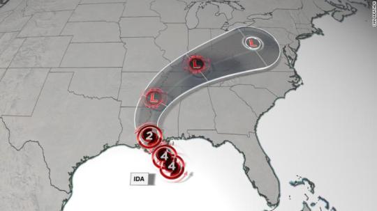
...EXTREMELY DANGEROUS HURRICANE DORIAN EXPECTED TO HIT THE ABACO ISLANDS AND GRAND BAHAMA ISLAND LATER TODAY...
...LIFE-THREATENING STORM SURGE...HURRICANE-FORCE WINDS...AND VERY HEAVY RAINFALL EXPECTED...
A Hurricane Warning is in effect for the Northwest Bahamas excluding Andros Island. A Hurricane Watch is in effect for Andros Island. A Tropical Storm Warning is in effect along the east Florida coastline from north of Deerfield Beach to Sebastian Inlet. A Tropical Storm Watch is in effect from north of Golden Beach to Deerfield Beach. Hurricane conditions are expected in the hurricane warning area across the Northwest Bahamas later today, with tropical storm winds beginning within the next few hours. Tropical storm conditions are expected within the tropical storm warning area on Monday. Tropical storm conditions are possible within the tropical storm watch area by Monday night. Interests elsewhere in South and Central Florida should continue to monitor the progress of Dorian. Additional watches or warnings may be required for portions of the east coast of Florida today.
Hurricane Dorian is centered as of 5 a.m. EDT about 70 miles (110 km) east of Abaco Island and about 255 miles (410 km) east of West Palm Beach, Florida. Dorian is moving toward the west near 8 mph (13 km/h), and a slower westward motion should occur for the next day or two, followed by a gradual turn toward the northwest. On this track, the core of Dorian should be near or over portions of the northwestern Bahamas later today and tonight, and should move closer to the Florida east coast late Monday through Tuesday night.
Maximum sustained winds are near 150 mph (240 km/h) with higher gusts. Hurricane-force winds extend outward up to 30 miles (45 km) from the center, and tropical-storm-force winds extend outward up to 105 miles (165 km). Dorian is a category 4 hurricane on the Saffir-Simpson Hurricane Wind Scale. Some fluctuations in intensity are likely, but Dorian is expected to remain a powerful hurricane during the next few days.
A life-threatening storm surge will raise water levels by as much as 15 to 20 feet above normal tide levels in areas of onshore winds on the Abaco Islands and Grand Bahama Island. Near the coast, the surge will be accompanied by large and destructive waves.
Dorian is expected to produce the following rainfall totals through late this week:
Northwest Bahamas...12 to 24 inches, isolated 30 inches.
Coastal Carolinas...5 to 10 inches, isolated 15 inches.
Central Bahamas and the Atlantic Coast from the Florida peninsula through Georgia...2 to 4 inches, isolated 6 inches.
This rainfall may cause life-threatening flash floods.
The next complete advisory will be issued by NHC at 11 a.m. EDT with an intermediate advisory at 8 a.m. EDT - www.hurricanes.gov
0 notes
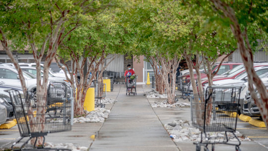
Photo
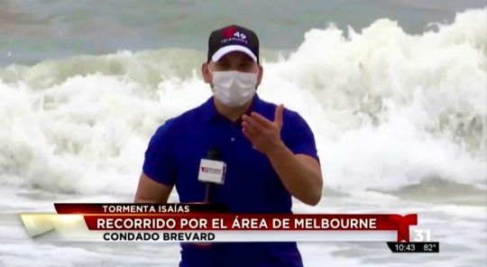
#Isaías, que llegó a ser #huracán Categoría 1 y causó daños significativos en varias islas del Caribe y las Bahamas, sobre todo por la intensidad de las lluvias que acarreaba, aquí en #Florida por suerte para todos no pasó a mayores. Hoy le decimos adiós ✌️ y agradecemos porque todo continúe en su lugar. . #hurricaneseason #hurricane #hurricaneisaias #reporterlife #reporter #journalist #hurricanetracker #stormtracker #weatherthestorm #storm #thanks #thankful (at Melbourne Beach, Florida) https://www.instagram.com/p/CDa-8_mnwxi/?igshid=pill8tfb9bzj
#isaías#huracán#florida#hurricaneseason#hurricane#hurricaneisaias#reporterlife#reporter#journalist#hurricanetracker#stormtracker#weatherthestorm#storm#thanks#thankful
1 note
·
View note
Photo

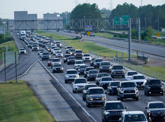
Hurricane Ida , as federal authorities warned of
#Hurricane#NationalHurricaneCenter#HurricaneKatrina#HurricaneIdaUpdate#NoaaHurricane#HurricaneTracker#HurricaneIda2021#NewOrleans
0 notes
Photo
Tracking a disturbance out in the Atlantic that is headed for the Gulf. It's expected to enter into the Gulf by Friday night. . . . #hurricanetracker #plannercommunity #planneraddict #trackeraddict (at Liza's Planner) https://www.instagram.com/p/CTCmaLrrB3w/?utm_medium=tumblr
0 notes
Video
instagram
Hurricane Lane Location as of 4:42 p.m. HST. #hurricanelane . 8.22.18 . #hurricanelane #hurricanetracking #hawaii #oahu #808hawaii #808state #808 #bigislandhawaii #bigisland #maui #lanai #molokai #kauai #niihau (at Honolulu, Hawaii) https://www.instagram.com/p/BmzhX8MjEtc/?utm_source=ig_tumblr_share&igshid=1qx5tt6k5v4s6
#hurricanelane#hurricanetracking#hawaii#oahu#808hawaii#808state#808#bigislandhawaii#bigisland#maui#lanai#molokai#kauai#niihau
0 notes
Photo

Going to be bad in Florida no matter what the track will be. #trackingirma #hurricaneirma #floridalife #floridakeys #floridahurricane #yikes #hurricanetracking #florida #orlando #orlandoflorida (at Orange Tree, Orlando, Florida)
#yikes#orlandoflorida#hurricaneirma#floridahurricane#floridakeys#florida#floridalife#trackingirma#hurricanetracking#orlando
0 notes
Photo

@hurricanetracker @hurricanedorianupdates @hurricanedorian #hurricanedorian #hurricane https://www.instagram.com/p/B16McbVJROw/?igshid=1x56zd2kju32p
0 notes
Photo
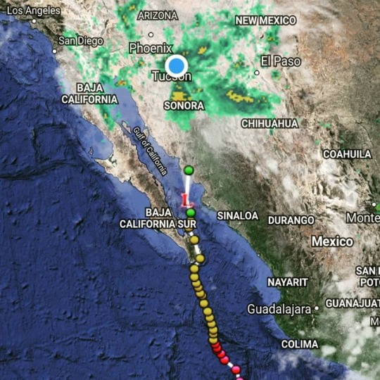
LOL Whodathunk we needed to track hurricanes here, of all places! I though leaving Florida would also mean leaving hurricanes behind. I guess that's where the "monsoons" come from? Since monsoon season starts tomorrow. Really, it's not bad. It is trying so hard to rain. Just hasn't "graduated" yet. Just spitting... ⛈🌀🌀🌀🌀⛈ #hurricane #hurricanetracker #monsoon #monsoons #monsoonseason #monsoonseason2018 #rain #weather #Tucson #tucsonlife #tucsonliving #igerstucson #igersarizona #arizona #arizonalife #arizonaliving #desertlife #desert #desertliving (at Vail, Arizona)
#desertliving#hurricane#weather#igersarizona#arizona#desert#monsoons#tucsonlife#arizonalife#arizonaliving#monsoonseason2018#rain#monsoonseason#tucson#tucsonliving#monsoon#desertlife#hurricanetracker#igerstucson
0 notes
Photo
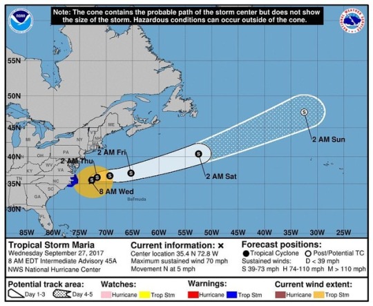
Maria down to a tropical storm and moving slowly but she will pick up some major speed soon as she is picked up by the jet stream and moved eastward. #maria #tropicalstorm #tropicalstormmaria #hurricanemaria #radar #forecast #beprepared #hurricanetrack #hurricaneseason #northcarolina #northcarolinaweather #weather #wx #meteorology #meteorologist #weathergoddess
#northcarolina#hurricanetrack#weather#forecast#hurricaneseason#radar#beprepared#hurricanemaria#northcarolinaweather#wx#meteorology#tropicalstormmaria#weathergoddess#meteorologist#tropicalstorm#maria
0 notes
Text
I am now concerned about some new rumors that are now circulating by mouth and social media and I felt a strong need to bring attention to it since I believe there is more to the story than is being circulated. This rumor could have serious consequences...enough for people to begin turning their backs on those that are left in Abaco, therefore, I feel it needs to be addressed quickly and swiftly. The last thing we do not need to be doing is passing judgments on the same people that are suffering incomprehensible amounts of turmoil. So, let me address it....
The Rumor:
People are refusing to get on flights to Eleuthera because "they want to be taken to the US instead". "Flights are arriving empty or not to capacity in Eleuthera."
The Rest of the Story:
Apparently, despite what is being reported by the government and the media, they ARE STILL CHARGING $75-$150 to be transported by plane off the island. This was literally confirmed by a reputable source less than an hour ago. You can hear him speak of it in another post on this page.
The point in my post....Please be very careful with what you believe and allow sink in. I have noticed that it is the people that have most reputable sources of information. Once we have been able to hear from them, their is usually a very logical reason for what is being said and it makes the entire story make sense. There have been numerous ONE-SIDED rumors in hopes to make one group of person's look good, while making the others look bad.
I admit that I personally cannot confirm that the rumor is true about charging the $76-$150 a person to get off the island, but I can tell you that once I heard that this may possibly be the case, it made a little more sense as to why those planes are landing without being fully occupied.
Be careful about what you believe. There are lives on the line that can be seriously affected by misinformation.
0 notes
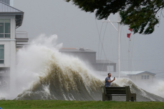
Photo
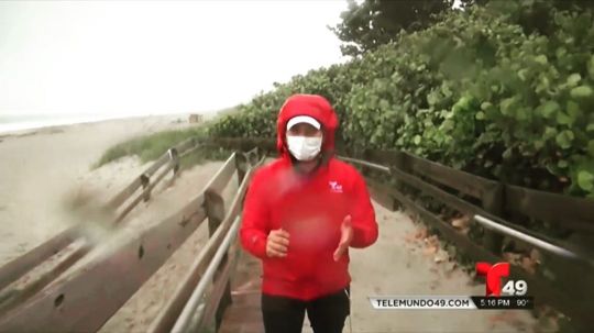
Cubrir Tormenta/Huracán/Tromentita (Isaías) con una mascarilla, es sin dudas el mayor ejercicio de respiración que he practicado en mi vida 😷. . #hurricane #hurricaneisaias #hurricaneseason #storm #tropicalstorm #huracánisaías #telemundo #telemundo31 #telemundo49 #hurricanetracker #reporterlife (at Melbourne Beach, Florida) https://www.instagram.com/p/CDZ9XyFHDDs/?igshid=1lqxe2r0n0qav
#hurricane#hurricaneisaias#hurricaneseason#storm#tropicalstorm#huracánisaías#telemundo#telemundo31#telemundo49#hurricanetracker#reporterlife
1 note
·
View note
Photo
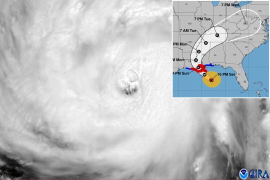
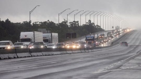
. Near where Ida comes ashore, the National Hurricane Center is predicting “potentially catastrophic” wind damage and an “extremely
#HurricaneIda#NationalHurricaneCenter#Hurricane#Ida#HurricaneKatrina#HurricaneTracker#IdaStorm#HurricaneIda2021
0 notes
Photo
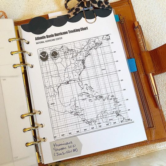
With all the storming going on today, and Hurricane Season just around the corner, I thought I'd get my tracker set up.... . . . #hurricanetracker #storms #stationeryaddict #plannercommunity #planneraddict #gilliofirenze #a5planner (at Liza's Planner) https://www.instagram.com/p/CPEDoaapT7V/?utm_medium=tumblr
0 notes
Text
‘Nuvem de poeira Godzilla’ é tão prejudicial quanto coronavírus
A notícia da chegada da ‘nuvem de poeira Godzilla’ rodou o mundo nesta quarta-feira, 24, e causou muito desespero e preocupação… Mas, afinal, quais os danos que ela pode causar para saúde humana?
A presença da nuvem cheia de partículas de ar seco e empoeirado pode causar danos à respiração das pessoas. E quem tem doenças respiratórias, como asma e rinite, sentirá a presença dela com mais agressividade.
Isso porque o ar tem aproximadamente 50% menos umidade do que a atmosfera tropical típica, o que pode afetar a pele e os pulmões, além de causar alergias e irritações nos olhos.
Segundo a BBC, os sinais deste fenômeno se agravam ainda mais se unidos à epidemia do novo coronavírus. Tanto é que as autoridades sanitárias de alguns países têm alertado sobre o risco extra da nuvem de poeira para pessoas com problemas respiratórios.
No domingo, o departamento de Saúde de Porto Rico alertou que pessoas com asma, problemas respiratórios e alergias, assim como aqueles que foram contaminados com covid-19, deveriam tomar medidas extras de cautela e proteção.
A computer model forecast of atmospheric dust for the next 10 days. The plume of Saharan dust is expected to move over the Southeastern US next week. The dust will be primarily at higher altitudes, so the main impact will be some especially colorful sunrises sunsets pic.twitter.com/bBzFp06lCu
— NWS Eastern Region (@NWSEastern) June 19, 2020
https://platform.twitter.com/widgets.js
O QUE É ESSA NUVEM, AFINAL?
Uma massa de ar seco que está carregada de partículas de areia se forma sobre o deserto do Saara no final da primavera, no verão e no começo do outono no Hemisfério Norte, todos os anos, e geralmente se desloca em direção ao Oeste sobre o Oceano Atlântico a cada três ou cinco dias.
Quando ocorre, costuma ser de curta duração, geralmente em torno de uma semana. Contudo, em 2020, surgiram ventos suaves em certas épocas do ano que tornaram mais propenso o cruzamento da nuvem para o Atlântico.
Ok, last dust pic for today and this one is perhaps the most incredible yet. The comparison photos were sent to me from Mirco Ferro who lives in St. Barthelemy. Check the dates in the photos (top is from March) – both are unfiltered or altered in any way. #SAL #DUST pic.twitter.com/FBwOG5ly1E
— Mark Sudduth (@hurricanetrack) June 21, 2020
https://platform.twitter.com/widgets.js
Veja também: No JN, William Bonner demonstra preocupação com nuvem de gafanhotos
‘Nuvem de poeira Godzilla’ é tão prejudicial quanto coronavíruspublicado primeiro em como se vestir bem
0 notes