#Land survey and mapping
Explore tagged Tumblr posts
Visit Tumblr Blog
Explore Tumblr blogs with no restrictions, modern design and the best experience.
Last Seen Tumblr Blogs


Fun Fact
Tumblr has been providing a Korean-language service since 2013.
Text

The Importance of Land Acquisition and Monitoring for Sustainable Development
Land acquisition and monitoring play a crucial role in shaping sustainable development by ensuring that land resources are used efficiently, equitably, and responsibly. Whether for infrastructure development, urban expansion, or agricultural projects, these processes must align with environmental and social goals. As the demand for land increases, the use of advanced tools like land management software, GIS-based land management systems, and land asset management software has become critical for driving sustainable outcomes.
#Land acquisition#Land acquisition process#Sustainable development#Land monitoring#Sustainable land management#Land management system#cyberswift#GIS-based land management#Land use planning#Environmental sustainability#Land records management#Land survey and mapping#Land asset management#Digital land monitoring#victoryofgoodoverevil#Sustainable land practices#Regulatory compliance in land acquisition#Role of technology in land monitoring#land management software#land management solutions#land asset management software#land management system#land acquisition software#land management system software#Land software#Land Allotment Software#Land Information management System#GIS based land management System#GIS based land records management#Land Records Management System
0 notes
Text
How CAD Technology Transforms Accuracy and Efficiency in Land Surveying

Land surveying is a critical process in the fields of construction, engineering, and land development. It involves measuring and mapping the terrestrial or three-dimensional space to determine boundaries, land features, and property lines. Traditionally, land surveying relied heavily on manual techniques and rudimentary tools, leading to time-consuming and often error-prone results. However, with the advent of Computer-Aided Design (CAD) technology, the landscape of land surveying has transformed dramatically. CAD has brought about significant improvements in accuracy and efficiency, revolutionizing the industry. In this blog post, we will delve into the various ways CAD enhances land surveying and explore its benefits in detail.
The Role of CAD in Land Surveying
CAD, or Computer-Aided Design, is a technology used for creating, modifying, analyzing, and optimizing designs. In the context of land surveying, CAD software helps surveyors create detailed and precise maps and plans of land areas. The integration of CAD in land surveying involves the use of specialized software that allows surveyors to input data, process measurements, and generate accurate digital representations of physical spaces.
Enhanced Accuracy
One of the most significant advantages of CAD in land surveying is the enhanced accuracy it provides. Traditional surveying methods often involved manual calculations and hand-drawn maps, which were susceptible to human error. In contrast, CAD software offers tools that automate many of these processes, reducing the likelihood of mistakes. Here are some ways CAD improves accuracy:
1. Precision in Measurements: CAD software can handle and process complex mathematical calculations with precision. Surveyors can input raw data collected from the field directly into the software, which then accurately converts these measurements into detailed maps and models. This eliminates errors associated with manual data entry and calculation.
2. Detailed and Scalable Maps: CAD allows for the creation of highly detailed and scalable maps. Surveyors can zoom in and out without losing accuracy, enabling them to examine specific areas closely and ensure every detail is accounted for. This level of detail is crucial for identifying potential issues and making informed decisions.
3. Real-Time Data Processing: Modern CAD software can process data in real time, providing surveyors with immediate feedback. This capability allows for quick adjustments and corrections in the field, ensuring that the final survey is as accurate as possible.
4. Integration with GPS and GIS: CAD software often integrates seamlessly with Global Positioning System (GPS) and Geographic Information System (GIS) technology. This integration allows surveyors to import precise location data directly into their CAD models, further enhancing accuracy and providing a comprehensive view of the surveyed area.
Increased Efficiency
Efficiency is another key area where CAD excels in land surveying. The traditional surveying process was labor-intensive and time-consuming, often requiring surveyors to spend days or even weeks in the field. CAD technology streamlines many aspects of this process, leading to significant time savings and increased productivity. Here’s how CAD boosts efficiency in land surveying:
1. Automated Data Processing: CAD software can automate many of the repetitive and time-consuming tasks involved in land surveying. For example, it can automatically generate contour lines, calculate areas and volumes, and create cross-sections. This automation reduces the workload on surveyors and speeds up the overall process.
2. Simplified Data Management: Managing large amounts of data can be challenging, especially in large-scale land surveying projects. CAD software offers robust data management tools that allow surveyors to organize, store, and retrieve data easily. This simplifies the workflow and ensures that all information is readily accessible when needed.
3. Collaborative Capabilities: CAD software often includes collaborative features that enable multiple team members to work on the same project simultaneously. This collaborative approach enhances communication and coordination, leading to faster completion times and fewer misunderstandings.
4. Efficient Fieldwork: With CAD, surveyors can use mobile devices and specialized equipment to collect data in the field more efficiently. This data can be uploaded to the CAD software on the go, reducing the need for repeated site visits and minimizing downtime.
Visualization and Analysis
Visualization and analysis are critical components of land surveying, and CAD technology excels in these areas as well. The ability to create detailed visual representations of surveyed areas and perform in-depth analyses is invaluable for surveyors, engineers, and developers. Here are some ways CAD enhances visualization and analysis:
1. 3D Modeling: CAD software enables surveyors to create three-dimensional models of land areas. These 3D models provide a realistic representation of the terrain, allowing for better analysis and planning. Stakeholders can visualize the land’s topography, identify potential challenges, and make informed decisions based on accurate data.
2. Overlaying Data: CAD allows for the overlaying of different types of data on a single map. For example, surveyors can combine topographical data with utility lines, property boundaries, and environmental features. This comprehensive view helps in identifying potential conflicts and planning accordingly.
3. Simulation and Scenario Planning: CAD software can simulate various scenarios and predict their outcomes. For instance, surveyors can model the impact of construction on a particular area, assess potential drainage issues, or analyze the effects of environmental changes. This capability aids in proactive planning and risk management.
4. Detailed Reports and Documentation: CAD software can generate detailed reports and documentation based on the surveyed data. These reports can include measurements, calculations, maps, and 3D models, providing a comprehensive overview of the surveyed area. Such documentation is essential for legal, regulatory, and planning purposes.
Cost Savings
The improvements in accuracy, efficiency, and visualization brought about by CAD also translate into significant cost savings. By reducing errors and streamlining processes, CAD helps surveyors and their clients save money in various ways:
1. Reduced Rework: Accurate surveys mean fewer mistakes and less rework. Errors in traditional surveys often led to costly revisions and delays. CAD minimizes these errors, ensuring that the project stays on schedule and within budget.
2. Optimized Resource Allocation: Efficient data processing and management allow surveyors to optimize the use of resources, including time, labor, and equipment. This optimization leads to cost savings and better project management.
3. Minimized Site Visits: With the ability to process and analyze data remotely, CAD reduces the need for multiple site visits. This not only saves time but also reduces travel and labor costs.
4. Improved Decision-Making: Accurate and detailed surveys provide valuable insights that aid in decision-making. This leads to better project planning, fewer unforeseen issues, and more efficient use of resources, all of which contribute to cost savings.
Future Prospects of CAD in Land Surveying
As technology continues to advance, the role of CAD in land surveying is expected to grow even more significant. Emerging technologies such as Building Information Modeling (BIM), drones, and LiDAR (Light Detection and Ranging) are being integrated with CAD software, further enhancing its capabilities. Here are some future prospects for CAD in land surveying:
1. Integration with Drones: Drones equipped with high-resolution cameras and LiDAR sensors can capture detailed aerial imagery and topographical data. This data can be imported into CAD software for precise mapping and analysis. The use of drones reduces the time and effort required for fieldwork and provides access to hard-to-reach areas.
2. Building Information Modeling (BIM): BIM is a digital representation of the physical and functional characteristics of a building. Integrating BIM with CAD allows for a seamless transition from land surveying to construction planning and management. This integration improves collaboration between surveyors, architects, and engineers, leading to more efficient project execution.
3. Augmented Reality (AR) and Virtual Reality (VR): AR and VR technologies can enhance the visualization capabilities of CAD software. Surveyors and stakeholders can use AR and VR to explore 3D models in an immersive environment, gaining a better understanding of the terrain and potential challenges. This immersive experience aids in decision-making and improves communication.
4. Artificial Intelligence (AI) and Machine Learning: AI and machine learning algorithms can analyze large datasets quickly and accurately. When integrated with CAD, these technologies can automate complex analyses, identify patterns, and predict potential issues. This capability enhances the efficiency and accuracy of land surveying.
Conclusion
CAD has revolutionized the field of land surveying by improving accuracy, efficiency, and visualization capabilities. The precision and automation offered by CAD software reduce errors and streamline processes, leading to significant time and cost savings. As technology continues to evolve, the integration of CAD with emerging technologies such as drones, BIM, AR, VR, and AI will further enhance its capabilities, making land surveying even more efficient and accurate. For surveyors, engineers, and developers, embracing CAD technology is not just an option but a necessity for staying competitive and delivering high-quality results in today's fast-paced and demanding environment.
#Land Surveying#outsource cad drafting services#Surveying#Land Survey#Land Surveying Software#Land Survey Drafting Services#Land Survey CAD Drafting Services#Alta Survey#Subdivision Plats#Title Survey#Pipeline Surveys#Construction Survey#Site Planning Survey#Boundary and Location Survey#Topographic Survey#Residential Mortgage Survey#Tower Survey#Radius Map#Utility survey
2 notes
·
View notes
Text
Meta Geomatics Property Survey Company
A property survey company plays a crucial role in real estate transactions by providing comprehensive assessments of land and structures. These surveys offer invaluable insights into property boundaries, easements, encroachments, and other critical details essential for legal and development purposes.
Expert surveyors employ advanced technologies like GPS, drones, and 3D scanning to ensure accuracy and efficiency in their evaluations. Whether it's for residential, commercial, or industrial properties, these companies deliver detailed reports that aid in decision-making processes for buyers, sellers, and developers.
Moreover, property survey companies serve as guardians of property rights, helping clients navigate complex regulatory requirements and resolve disputes over land ownership or usage. By leveraging their expertise and cutting-edge tools, they contribute to the smooth functioning of real estate markets and the sustainable development of communities. In essence, partnering with a reputable property survey company is an indispensable step towards ensuring transparency, legality, and peace of mind in any property transaction.
#land survey company#land surveying company#Laser Scanning#Scan to BIM#3D Mapping#property survey company
2 notes
·
View notes
Text
Exploring the Diverse Landscape of Surveys: Unveiling Different Types
Introduction Civil engineering, as a discipline, relies heavily on accurate and comprehensive data to design, plan, and construct various infrastructure projects. Surveys play a crucial role in gathering this essential information, providing engineers with the data needed to make informed decisions. There are several types of surveys in civil engineering, each serving a unique purpose. In this…

View On WordPress
#accurate measurements#as-built survey#boundary survey#civil engineering data#Civil engineering surveys#construction progress monitoring#construction survey#design accuracy#environmental monitoring#geodetic survey#global mapping#hydrographic survey#infrastructure development#infrastructure projects#land surveyor#legal boundaries#monitoring survey#project planning#property lines#structural integrity assessment#surveying in civil engineering#surveying innovations#surveying technology#topographic surveying#water body survey
2 notes
·
View notes
Text
How is Drone Technology Shaping Surveying and Mapping in the UAE? Explore the Benefits
Technology continues to revolutionize conventional Emirates industries with extraordinary speed throughout the rapidly changing environment of the United Arab Emirates. Drone surveying and mapping represents a transformative monitoring system which changes our methods of visual and quantitative analysis of the real world environment. Drones along with their advanced sensing capabilities offer insights to Dubai's skyline and Abu Dhabi's infrastructure expansion and the vast arid terrains between them which was previously inaccessible or financially unreachable.

The Rise of Aerial Precision in the Emirates
The UAE's progressive development plan requires both specific and efficient and inventive approaches. surveying through traditional methods struggles to handle complex terain conditions and large construction works and continuous area monitoring requirements in the UAE. Drone Surveying & Mapping UAE services serve as the ideal solution because they provide accurate data acquisition functions that deliver fast operations and affordable solutions.
Applications Transforming Industries
Construction and Infrastructure Development
The architectural wonders of the nation receive vital lifecycle support from drone technologies used in construction projects. The mapping process through the air ensures the timely completion of projects and budget goals, together with quality maintenance.
Urban Planning and Smart City Initiatives
Detailed topographical information combined with 3D modeling functionality provided by drone surveys is the key form of support for UAE smart city implementation. The collected information helps city planners create data-based strategies regarding future city expansion and required infrastructure systems and environmental stewardship.
Oil and Gas Exploration
The energy industry adopts drone technology to provide safer remote site inspection services and drilling site mapping and remote pipeline surveillance through rugged terrain. The decrease of employee hazards at work sites becomes a major operational improvement point through drones.
Environmental Monitoring and Conservation
The utilization of drones enables ecological researchers to study ecological habitats while protecting sensitive natural environments since they offer exclusive data access.
Technological Capabilities
Three core features of contemporary drone surveying capabilities offer multiple sensing technologies and information processing features:
The use of LiDAR technology allows surveyors to create thorough three-dimensional point cloud data arrays.
Multispectral and thermal imaging for advanced analysis
Photogrammetry software generating centimeter-accurate ortho mosaic maps
Real-time data transmission for immediate decision-making

Regulatory Framework and Future Outlook
The UAE government has constructed evolving rules which achieve a harmony between advancements in technology while addressing safety and privacy matters. A licensed drone operator needs to follow stringent rules which become especially important while flying around airspace adjacent to airports as well as government buildings and residential districts. As technology progresses more laws are generated while new practical applications become available.
The future of Drone Surveying & Mapping UAE looks exceptionally bright. The implementation of artificial intelligence for both automated flight pattern operation and data evaluation processes will provide constantly developing capacities. Professionals in mapping and surveying will exclusively depend on drones as their essential inspection tool because of ongoing improvements in flight duration capabilities, sensor refinement and data analysis programming.
The Selection of an Ideal Drone Surveying Organization is Vital for Success
Organizations must carefully choose their service provider when they want to utilize these beneficial technologies. Key considerations include:
Technical expertise and equipment quality
Your selection of a service provider should include operators who hold expertise within your industry niche.
The selection process should focus on how providers handle data processing functions as well as their delivery format capabilities.
Proper licensing and regulatory compliance
Privacy and data security protocols
The United Arab Emirates shows excellence in technological leadership which serves as the perfect setting to advance drone surveying and mapping applications further. Supersmart flying data-gathering systems are becoming both more powerful and widely accessible while changing our ways of comprehending and developing physical aspects of our world. Drone technology serves as a modern essential asset in the Emirates' path toward impressive development activities as it supports both architectural advancements and natural terrain protection initiatives.
Accurate Survey offers expert drone surveying and mapping services in UAE. If you would like to explore more you can visit the page.
0 notes
Text
Land Survey Equipment Market – Trends, Growth & Forecast

The Land Survey Equipment Market is evolving rapidly due to increasing urbanization, infrastructure expansion, and technological advancements. Land surveying plays a critical role in industries such as construction, mining, agriculture, and transportation, ensuring precise mapping and terrain assessment.
With the market expected to grow from USD 9.0 billion in 2023 to USD 11.7 billion by 2028 at a CAGR of 5.2%, innovations such as GNSS, UAV-based mapping, and automation are set to redefine surveying methodologies.
This blog explores the key drivers, challenges, market trends, and growth opportunities shaping the future of the Land Survey Equipment Market.
Market Drivers: Why Demand is Rising?
1. Growing Infrastructure and Smart City Development
Land survey equipment plays a crucial role in road construction, bridges, railway networks, and smart city planning. Countries like India, China, and the US are investing heavily in urban expansion and smart city projects, driving the demand for high-precision surveying tools.
For instance, India’s ambition to achieve a USD 5 trillion economy by 2025 has led to large-scale infrastructure contracts. The Dubai government’s investment in Jammu and Kashmir’s infrastructure (2021) further highlights the global importance of surveying equipment.
2. Increasing Adoption of GNSS and GPS Technology
Advanced GNSS and GPS-integrated systems have significantly improved the accuracy and speed of land surveys. These technologies enable real-time positioning, topographical mapping, and geospatial data collection, making them essential for industries like construction, oil & gas, defense, and agriculture.
3. Renewable Energy Expansion
The global push for solar, wind, and hydroelectric energy requires precise terrain mapping and site planning. Land survey equipment ensures optimal placement of solar panels and wind turbines to maximize energy efficiency. As the renewable energy sector grows, the need for high-tech land survey solutions is increasing.
Download Pdf Brochure: https://www.marketsandmarkets.com/pdfdownloadNew.asp?id=261922059
Challenges in the Land Survey Equipment Market
1. High Cost of Advanced Survey Equipment
Despite the advantages of automation and robotics in land surveying, the high cost of implementation limits its adoption, especially for small and medium-sized enterprises (SMEs).
2. Shortage of Skilled Surveyors
The industry faces a shortage of trained professionals capable of handling UAV-based surveying, 3D laser scanning, and GNSS receivers. Training programs and certifications are required to bridge this skill gap.
Emerging Trends & Market Opportunities
1. Subscription and Rental-Based Surveying Equipment Models
Companies are adopting subscription and rental models to reduce capital expenditure while accessing state-of-the-art surveying tools. This trend benefits businesses looking for cost-effective solutions without heavy upfront investments.
2. UAVs and Drones in Land Surveying
Drones equipped with LiDAR sensors and high-resolution cameras are transforming land surveying by enabling faster, more accurate, and cost-efficient mapping solutions.
Market Segmentation: Who Are the Key Users?
By Solution: Hardware (GNSS receivers, UAVs, total stations) dominates.
By Industry: Construction & Mining lead, followed by Renewable Energy.
By Region: Asia-Pacific is the fastest-growing market.
Ask For Sample Report: https://www.marketsandmarkets.com/requestsampleNew.asp?id=261922059
Key Players in the Market
Leading companies in the Land Survey Equipment Market include:
✅ Hexagon AB (Sweden) ✅ Trimble Inc. (US) ✅ Topcon Corporation (Japan) ✅ CHC Navigation (China) ✅ Hi-Target (China)
These companies are investing in AI-driven survey solutions, automation, and advanced GNSS technologies to stay competitive.
What’s Next?
The Land Survey Equipment Market is on an upward trajectory, driven by technological advancements, infrastructure projects, and automation trends. As companies invest in UAV-based surveys and GNSS-integrated solutions, the demand for precise and efficient survey tools will continue to rise.
For businesses in construction, mining, agriculture, and renewable energy, adopting next-generation survey equipment will be key to staying ahead in an evolving landscape.
#land survey equipment market#gnss surveying#uav survey systems#3d laser scanning#infrastructure development#land mapping
0 notes
Text
Satellite Survey of Land in India: Transforming Resource Management
Satellite surveys are revolutionizing the way we perceive and manage land resources in India. By leveraging state-of-the-art remote sensing technology, satellite surveys provide unparalleled accuracy and detailed insights into land, water, and environmental resources. At Bhoojal Survey, we harness these advancements to support sustainable development and data-driven decision-making.
#satellite survey#satellite survey app#satellite survey map#satellite survey land records#satellite survey machine#satellite survey of land India#satellite survey equipment#satellite survey cost
0 notes
Text
Satellite Survey of Land in India: Transforming Resource Management
Satellite surveys are revolutionizing the way we perceive and manage land resources in India. By leveraging state-of-the-art remote sensing technology, satellite surveys provide unparalleled accuracy and detailed insights into land, water, and environmental resources. At Bhoojal Survey, we harness these advancements to support sustainable development and data-driven decision-making.
#groundwater#hydrogeology#geophysical engineering#satellite survey#satellite survey app#satellite survey map#satellite survey land records#satellite survey machine#satellite survey of land India#satellite survey equipment#satellite survey cost
0 notes
Text
Satellite Survey of Land in India: Transforming Resource Management
Satellite surveys are revolutionizing the way we perceive and manage land resources in India. By leveraging state-of-the-art remote sensing technology, satellite surveys provide unparalleled accuracy and detailed insights into land, water, and environmental resources. At Bhoojal Survey, we harness these advancements to support sustainable development and data-driven decision-making.
#satellite survey#satellite survey app#satellite survey map#satellite survey land records#satellite survey machine#satellite survey of land India#satellite survey equipment#satellite survey cost
0 notes
Text
The Role of Satellite Survey Maps in Urban and Rural Development
Satellite survey maps have become indispensable tools in modern urban and rural development. Leveraging advanced remote sensing technology, satellite mapping provides accurate, high-resolution data critical for infrastructure planning, resource management, and environmental conservation. In the context of India’s rapid urbanization and evolving rural landscape, satellite surveys play a pivotal role in addressing developmental challenges and enabling data-driven decision-making. This comprehensive blog delves into the significance, applications, and transformative potential of satellite survey maps in urban and rural development.
#satellite survey#satellite survey app#satellite survey map#satellite survey land records#satellite survey machine#satellite survey of land India#satellite survey equipment#satellite survey cost
0 notes
Text
Discover the Best Drone for Land Surveying in Georgia
Searching for the best drone for land surveying in Georgia? Enhance your surveying with advanced GPS, high-resolution imaging, and real-time data collection. Perfect for accurate, efficient, and cost-effective mapping, drones save time and improve safety, even in hard-to-reach areas. Take your land surveys to the next level with cutting-edge drone technology. Get started today for precision and efficiency!
0 notes
Text
Aerial Survey | Drone Survey | Drone Survey Company | AUAV
AUAV’s aerial survey using drones delivers efficient mapping and inspection data for industries across Australia. Let AUAV provide the aerial insights your projects need.

#Aerial Survey#Drone Mapping#Drone Survey#Aerial Mapping#Drone Mapping Solutions Australia#Drone Survey Mapping Solutions#Aerial Survey using Drones#Aerial Survey Mapping Drones#Drone Survey Company#Drones for Survey#Drone Land Surveying#Drone Surveying Australia
0 notes
Text
Unlocking the Power of Drone Surveying Services in Delhi: The Best Geospatial Solutions

In today’s fast-paced world, drone surveying services are proving to be a game-changer, especially in Delhi, where urban growth and infrastructure projects are booming. With the rapid advancements in drone technology in Delhi, industries have discovered a more efficient way to gather geospatial data, significantly transforming how surveys are conducted.
Aerial survey companies in Delhi are leading the charge by utilizing drones to provide high-precision data collection for a variety of industries. Whether it’s for construction, agriculture, or environmental monitoring, drones offer a level of accuracy that traditional methods simply can’t match. Gone are the days of relying on costly manual labor and time-consuming equipment. Instead, drones swiftly capture high-resolution images and 3D models, delivering valuable insights that streamline decision-making and reduce project timelines.
When searching for the best drone services, it’s crucial to choose a provider that offers comprehensive geospatial solutions. These solutions not only include aerial imagery but also topographical mapping, volumetric analysis, and real-time data collection. This makes drone services an invaluable asset for land assessments, project planning, and site management.
The rise of drone technology has made it easier for businesses to gather critical data in less time, at a lower cost, and with greater precision. Whether you need to monitor the progress of a construction project or assess land for agricultural purposes, drone surveying services in Delhi can provide the accuracy and speed needed to stay ahead of the competition.
With the continuous evolution of drone technology, the future of surveying is looking brighter than ever. By choosing the right aerial survey company in Delhi, you can unlock the full potential of drone technology and gain a competitive edge in your industry.
For innovative and reliable geospatial solutions, drone surveying services in Delhi offer the best way forward. Let the power of drones revolutionize your data collection processes and take your projects to new heights!
#drone technology#road construction#aerial mapping#surveying techniques#land development#construction planning
1 note
·
View note
Text
Road Condition Monitoring System(RCMS): Enhancing Efficiency with AI-Powered Solutions
The quality and sustainability of road infrastructure play a pivotal role in societal development, economic growth, and the safety of communities. To address the challenges of road construction and maintenance, advanced digital tools such as Road Condition Monitoring Systems (RCMS) are becoming indispensable. Leveraging technologies like AI-powered pothole detection, data analytics, and interactive visualization, RCMS ensures efficient planning, monitoring, and maintenance of road networks.
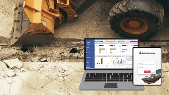
#ai and gis road monitoring solutions#geospatial road management solutions#geospatial road monitoring system#gis based pothole mapping and detection#gis based road condition monitoring system#gis based road inspection software#gis based road survey solutions#gis data analysis for road monitoring#gis mapping for road condition analysis#gis road maintenance solutions#land management system#gis tools for road condition assessment#pothole detection using gis technology#real time road condition monitoring gis#road condition assessment using gis#road condition monitoring using gis#road infrastructure monitoring with gis#road maintenance gis software#road safety monitoring with gis systems#road surface monitoring with gis#smart road condition monitoring gis
1 note
·
View note
Text
Topographic Survey Software
AutoPlotter Advanced delivers an affordable solution for everyday land surveying needs. Built on the powerful DTM engine of its Pro counterpart, it seamlessly processes data from total stations, GPS, or similar instruments. Generate professional topographic and contour maps, perform traverse adjustments, and coordinate conversion. Its built-in CAD tools let you create complete drawings, while features like instant map creation and 3D terrain views accelerate your workflow. Easy to learn and use, AutoPlotter Advanced is ideal for surveyors seeking productivity and affordability.
https://infycons.com/autoplotter/advanced/

#civil engineering and civil software#topographical survey#land survey#civil technology#cross section generation#topographic map#topographic survey#quantity calculation#software solutions
0 notes
Text

Aerius View
Aerius View connects project managers and decision-makers with trusted, local aerial surveyors, streamlining the search process for efficient and reliable surveying solutions. Our platform vets experts in drone surveying, ensuring high-quality results.
1 note
·
View note