#geospatial road monitoring system
Explore tagged Tumblr posts
Visit Tumblr Blog
Explore Tumblr blogs with no restrictions, modern design and the best experience.
Last Seen Tumblr Blogs


Fun Fact
Tumblr posted its first advertisements in May 2012 and subsequently earned $13M in revenue.
Text
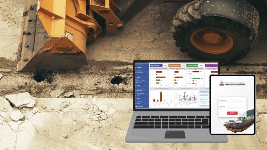
Road Condition Monitoring System(RCMS): Enhancing Efficiency with AI-Powered Solutions
The quality and sustainability of road infrastructure play a pivotal role in societal development, economic growth, and the safety of communities. To address the challenges of road construction and maintenance, advanced digital tools such as Road Condition Monitoring Systems (RCMS) are becoming indispensable. Leveraging technologies like AI-powered pothole detection, data analytics, and interactive visualization, RCMS ensures efficient planning, monitoring, and maintenance of road networks.
#ai and gis road monitoring solutions#geospatial road management solutions#geospatial road monitoring system#gis based pothole mapping and detection#gis based road condition monitoring system#gis based road inspection software#gis based road survey solutions#gis data analysis for road monitoring#gis mapping for road condition analysis#gis road maintenance solutions#land management system#gis tools for road condition assessment#pothole detection using gis technology#real time road condition monitoring gis#road condition assessment using gis#road condition monitoring using gis#road infrastructure monitoring with gis#road maintenance gis software#road safety monitoring with gis systems#road surface monitoring with gis#smart road condition monitoring gis
1 note
·
View note
Text
If you ever had pastries at breakfast, drank soy milk, used soaps at home, or built yourself a nice flat-pack piece of furniture, you may have contributed to deforestation and climate change.
Every item has a price—but the cost isn’t felt only in our pockets. Hidden in that price is a complex chain of production, encompassing economic, social, and environmental relations that sustain livelihoods and, unfortunately, contribute to habitat destruction, deforestation, and the warming of our planet.
Approximately 4 billion hectares of forest around the world act as a carbon sink which, over the past two decades, has annually absorbed a net 7.6 billion metric tons of CO2. That’s the equivalent of 1.5 times the annual emissions of the US.
Conversely, a cleared forest becomes a carbon source. Many factors lead to forest clearing, but the root cause is economic. Farmers cut down the forest to expand their farms, support cattle grazing, harvest timber, mine minerals, and build infrastructure such as roads. Until that economic pressure goes away, the clearing may continue.
In 2024, however, we are going to see a big boost to global efforts to fight deforestation. New EU legislation will make it illegal to sell or export a range of commodities if they have been produced on deforested land. Sellers will need to identify exactly where their product originates, down to the geolocation of the plot. Penalties are harsh, including bans and fines of up to 4 percent of the offender's annual EU-wide turnover. As such, industry pushback has been strong, claiming that the costs are too high or the requirements are too onerous. Like many global frameworks, this initiative is being led by the EU, with other countries sure to follow, as the so-called Brussels Effect pressures ever more jurisdictions to adopt its methods.
The impact of these measures will only be as strong as the enforcement and, in 2024, we will see new ways of doing that digitally. At Farmerline (which I cofounded), for instance, we have been working on supply chain traceability for over a decade. We incentivize rule-following by making it beneficial.
When we digitize farmers and allow them and other stakeholders to track their products from soil to shelf, they also gain access to a suite of other products: the latest, most sustainable farming practices in their own language, access to flexible financing to fund climate-smart products such as drought-resistant seeds, solar irrigation systems and organic fertilizers, and the ability to earn more through international commodity markets.
Digitization helps build resilience and lasting wealth for the smallholders and helps save the environment. Another example is the World Economic Forum’s OneMap—an open-source privacy-preserving digital tool which helps governments use geospatial and farmer data to improve planning and decision making in agriculture and land. In India, the Data Empowerment Protection Architecture also provides a secure consent-based data-sharing framework to accelerate global financial inclusion.
In 2024 we will also see more food companies and food certification bodies leverage digital payment tools, like mobile money, to ensure farmers’ pay is not only direct and transparent, but also better if they comply with deforestation regulations.
The fight against deforestation will also be made easier by developments in hardware technology. New, lightweight drones from startups such as AirSeed can plant seeds, while further up, mini-satellites, such as those from Planet Labs, are taking millions of images per week, allowing governments and NGOs to track areas being deforested in near-real time. In Rwanda, researchers are using AI and the aerial footage captured by Planet Labs to calculate, monitor, and estimate the carbon stock of the entire country.
With these advances in software and hard-tech, in 2024, the global fight against deforestation will finally start to grow new shoots.
5 notes
·
View notes
Text
How Data Science Powers Ride-Sharing Apps Like Uber
Booking a ride through apps like Uber or Ola feels effortless. You tap a button, get matched with a nearby driver, track your ride in real time, and pay digitally. But behind this seamless experience is a powerful engine of data science, working 24/7 to optimize every part of your journey.
From estimating arrival times to setting dynamic prices, ride-sharing platforms rely heavily on data to deliver fast, efficient, and safe rides. Let’s take a look at how data science powers this complex ecosystem behind the scenes.
1. Matching Riders and Drivers – In Real Time
The first challenge for any ride-sharing platform is matching passengers with the nearest available drivers. This isn’t just about distance—algorithms consider:
Traffic conditions
Driver acceptance history
Ride cancellation rates
Estimated time to pickup
Driver ratings
Data science models use all this information to ensure the best match. Machine learning continuously refines this process by learning from past trips and user behavior.
2. Route Optimization and Navigation
Once a ride is accepted, the app provides the most efficient route to the driver and rider. Data science helps in:
Predicting traffic congestion
Identifying road closures
Estimating arrival and drop-off times accurately
Ride-sharing companies integrate GPS data, historical traffic trends, and real-time updates to offer smart navigation—sometimes even beating popular map apps in accuracy.
3. Dynamic Pricing with Surge Algorithms
If you’ve ever paid extra during peak hours, you’ve experienced surge pricing. This is one of the most sophisticated use cases of data science in ride-sharing.
Algorithms analyze:
Demand vs. supply in real time
Events (concerts, sports matches, holidays)
Weather conditions
Traffic and accident reports
Based on this, prices adjust dynamically to ensure more drivers are incentivized to operate during busy times, balancing supply and demand efficiently.
4. Predictive Demand Forecasting
Data scientists at companies like Uber use predictive models to forecast where and when ride demand will increase. By analyzing:
Past ride data
Time of day
Day of the week
Local events and weather
They can proactively position drivers in high-demand areas, reducing wait times and improving overall customer satisfaction.
5. Driver Incentive and Retention Models
Driver retention is key to the success of ride-sharing platforms. Data science helps create personalized incentive programs, offering bonuses based on:
Ride frequency
Location coverage
Customer ratings
Peak hour availability
By analyzing individual driver patterns and preferences, companies can customize rewards to keep their best drivers motivated and on the road.
6. Fraud Detection and Safety
Security and trust are critical. Machine learning models continuously monitor rides for signs of fraud or unsafe behavior. These include:
Unexpected route deviations
Rapid cancellation patterns
Payment fraud indicators
Fake GPS spoofing
AI-powered systems flag suspicious activity instantly, protecting both riders and drivers.
7. Customer Experience and Feedback Loops
After every ride, passengers and drivers rate each other. These ratings feed into reputation systems built with data science. Natural language processing (NLP) is used to analyze written reviews, identify trends, and prioritize customer support.
Feedback loops help improve:
Driver behavior through coaching or deactivation
App features and interface
Wait time reduction strategies
Real-World Tools Behind the Scenes
Companies like Uber use a combination of technologies:
Big Data Tools: Hadoop, Spark
Machine Learning Libraries: TensorFlow, XGBoost
Geospatial Analysis: GIS, OpenStreetMap, Mapbox
Cloud Platforms: AWS, Google Cloud
These tools process millions of data points per minute to keep the system running smoothly.
Conclusion:
Ride-sharing apps may look simple on the surface, but they’re powered by an intricate web of algorithms, data pipelines, and real-time analytics. Data science is the backbone of this digital transportation revolution—making rides faster, safer, and smarter.
Every time you book a ride, you’re not just traveling—you’re experiencing the power of data science in motion.

#datascience#ridesharing#uber#aiintransportation#machinelearning#bigdata#realtimetechnology#transportationtech#appdevelopment#smartmobility#nschool academy#analytics
0 notes
Text
Land Surveys: Defining Boundaries with Unmatched Accuracy
Land surveys are an essential component of property ownership and development in Australia. They serve as the foundation for defining legal boundaries, resolving disputes, and ensuring construction compliance. Whether for residential subdivisions, infrastructure projects, or rural property assessments, land surveys play a vital role in shaping the landscape with precision and clarity.
These surveys are not merely about measuring distances. They involve a complex process that incorporates advanced technologies, legal knowledge, and detailed spatial analysis to establish exact property lines and geospatial features. In a country like Australia, with its vast and varied terrain, the need for accurate and reliable land surveys is more critical than ever.

Types of Land Surveys in Australia
Different projects require different types of land surveys, each serving a specific purpose:
Cadastral Surveys These are primarily concerned with property boundaries. Cadastral surveys are often required during property sales, subdivisions, and legal disputes to confirm ownership lines and compliance with land titles.
Topographic Surveys Used to map natural and man-made features of a parcel of land, topographic surveys are crucial for planning and development. They provide essential data on elevation, vegetation, structures, and drainage systems.
Construction Surveys These are conducted to guide construction projects, ensuring that buildings, roads, and utilities are positioned correctly according to design specifications.
Hydrographic Surveys Relevant for coastal and marine development, hydrographic surveys measure bodies of water to support navigation, dredging, and marine construction activities.
Engineering Surveys Engineering surveys support the design and monitoring of infrastructure such as highways, bridges, and pipelines.
The Technology Behind Land Surveys
Modern land surveys rely on sophisticated technology to achieve unmatched accuracy. Equipment such as Total Stations, GPS receivers, aerial drones, and 3D laser scanners enable surveyors to collect precise spatial data, even in challenging environments. Geographic Information Systems (GIS) and Computer-Aided Design (CAD) software are then used to process this data, producing detailed maps, models, and legal documents.
This integration of advanced tools ensures not only accuracy but also efficiency, reducing the risk of costly errors and delays in construction and legal processes.
Legal and Regulatory Framework in Australia
In Australia, land surveys must adhere to strict legal and regulatory standards. Licensed surveyors are the only professionals authorised to perform boundary surveys and issue certified survey plans. These professionals operate under legislation specific to each state and territory, ensuring consistency and legal validity across jurisdictions.
Survey plans must be lodged with the relevant government authorities, such as the land titles office, and are often necessary for land registration, development applications, and council approvals.
Why Accuracy Matters in Land Surveys
Precision in land surveys is not just a technical requirement—it’s a legal necessity. Incorrect boundaries can lead to disputes between property owners, complications in land development, and even litigation. Accurate surveys protect all parties involved in a land transaction and are indispensable for securing loans, obtaining insurance, and developing property without encroachments.
In urban environments, where space is limited and property values are high, the margin for error is extremely small. In rural and remote areas, surveys ensure proper land use and environmental compliance. Regardless of the setting, accurate land surveys provide a solid foundation for confident decision-making.
Applications of Land Surveys in Property Development
Property developers, architects, and engineers rely heavily on land surveys to guide every stage of a project—from initial planning to final inspection. Surveys influence:
Site layout and design feasibility
Compliance with zoning and planning regulations
Environmental impact assessments
Infrastructure placement and connectivity
Final handover and certification
Without precise land surveys, developments risk delays, non-compliance, and unexpected costs. Accurate data enables developers to mitigate risks and optimise the use of land in a responsible and profitable manner.
Choosing a Qualified Surveyor
For any project requiring land surveys, working with a qualified and licensed surveyor is essential. Surveyors must be accredited by the appropriate board in their state or territory and have extensive knowledge of local laws, terrain, and survey techniques.
When selecting a surveyor, consider their experience, reputation, and familiarity with the type of survey needed. A competent surveyor ensures not only technical accuracy but also legal reliability and regulatory compliance.
Conclusion: The Unseen Backbone of Property Ownership
Land surveys are the unseen backbone of property ownership, development, and infrastructure in Australia. They offer legal certainty, developmental clarity, and environmental responsibility. As urban areas expand and rural lands are repurposed, the demand for precise, reliable land surveys continues to grow.
From private homeowners to government agencies, anyone dealing with land has a vested interest in the integrity of these surveys. By investing in professional, accurate land surveys, stakeholders protect their assets, streamline their projects, and uphold the legal and spatial order that defines modern Australian landscapes.
0 notes
Text
Complete Guide to Drone and Aerial Survey Services – Epitome
In recent years, drone and aerial survey services have revolutionized how we collect, analyze, and interpret spatial data. These technologies are faster, more accurate, and more affordable than traditional survey methods. At Epitome, we provide state-of-the-art drone and aerial survey solutions to help clients across multiple sectors gain deep insights, improve planning, and enhance decision-making.
What Are Drone and Aerial Surveys?
Drone surveys involve the use of UAVs (Unmanned Aerial Vehicles) equipped with high-resolution cameras, LiDAR systems, or multispectral sensors to capture geospatial data from the air. These drones can fly over various terrains—mountains, fields, construction sites—and produce detailed 2D and 3D maps, models, and reports.
Aerial surveys, on the other hand, often use manned aircraft like helicopters or airplanes. These are better suited for large-scale projects or when higher altitude data capture is necessary. Both methods provide crucial geographic data, but drones are more flexible and cost-efficient for most small to medium-sized projects.
Applications of Drone and Aerial Surveys
At Epitome, we apply these technologies in various sectors, such as:
Construction & Real Estate: Monitor site progress, measure volumes, and generate 3D models of terrain and buildings.
Agriculture: Conduct crop health assessments, identify irrigation issues, and analyze soil patterns using multispectral imaging.
Mining: Perform volume calculations, pit analysis, and environmental monitoring without disrupting operations.
Infrastructure & Utilities: Inspect roads, railways, power lines, and pipelines with high precision.
Disaster Management: Assess flood, earthquake, or storm-affected areas quickly and safely.
Benefits of Using Drone and Aerial Surveying
These technologies offer a wide range of advantages over traditional methods:
Speed & Efficiency: Complete surveys in a fraction of the time.
Cost Savings: Reduce manpower and equipment costs.
High Accuracy: Use GNSS/GPS and LiDAR for precision mapping.
Access to Hard-to-Reach Areas: Survey rugged or dangerous terrains without risk to human life.
Real-Time Data Access: Get actionable insights quickly for time-sensitive projects.
How Epitome Delivers Excellence
At Epitome, we combine deep geospatial expertise with cutting-edge tools to ensure you receive accurate and reliable survey data. Our team evaluates each project individually, determining the right mix of drone or aerial technology based on your goals, location, and budget.
We follow a clear, structured approach:
Project Consultation & Planning
Flight Scheduling & Permits
On-Site Data Collection
Post-Processing & Analysis
Deliverables in Your Preferred Format (maps, models, reports)
Choosing the Right Survey Type When deciding between drone and aerial surveys, consider these key factors:
Project Size: Drones are ideal for smaller or more complex areas; manned aircraft work better for large regions.
Resolution Needs: Drones provide ultra-high-resolution imagery.
Budget & Timeline: Drones offer lower operational costs and faster deployment.
Access & Safety: Drones are perfect for surveying hazardous or restricted areas.
Conclusion
Drone and aerial survey technologies are no longer futuristic tools—they’re essential components of modern spatial analysis and planning. Whether you're managing infrastructure, agriculture, mining, or urban development, Epitome offers you the accuracy, speed, and insight needed to succeed.
0 notes
Text
Drone Mapping Technology: A New Era in Urban and Land Planning
Before the introduction of drones, large-scale mapping and surveying relied heavily on helicopters—an expensive and often risky method. Today, drone technology has revolutionized this field, offering a safer, faster, and more cost-effective solution. The core goal of aerial drone mapping is to produce accurate 2D or 3D maps of a survey area, using data captured from above. One crucial element in this process is geospatial data—each data point must correspond to a real-world location with exact coordinates.

The Impact of Drones on Surveying and Mapping Drones have transformed the way we conduct land surveys and gather critical geospatial data. Equipped with advanced sensors and cameras, drones are now widely used to capture high-resolution images and precise measurements from the air. Surveyors and engineers leverage this technology to generate detailed maps and 3D models for a wide range of applications. These drones utilize aerial photogrammetry, allowing data to be collected from multiple angles, resulting in highly detailed and usable outputs.
Whether for measuring terrain, planning expeditions, or developing urban infrastructure, aerial drone mapping provides an efficient and practical solution. This advanced method has become indispensable in various sectors, including construction, agriculture, mining, and urban planning.
Why Aerial Drone Mapping is a Game-Changer
Drone mapping services have emerged as essential tools in modern surveying for several compelling reasons:
1. High Precision and Accuracy Drones use aerial photogrammetry to generate high-resolution, centimeter-accurate maps. This level of precision significantly reduces data collection errors and improves planning reliability.
2. Time and Cost Efficiency Compared to traditional surveying methods, drones can cover larger areas in significantly less time, reducing labor requirements and project costs.
3. Access to Challenging Terrains Drones can easily access remote or hazardous locations, such as steep hillsides, dense forests, or active construction zones, ensuring comprehensive coverage without putting surveyors at risk.
4. Real-Time Data Access Modern drone systems integrate with cloud-based platforms, allowing real-time data processing and sharing. This enhances project collaboration and speeds up decision-making processes.

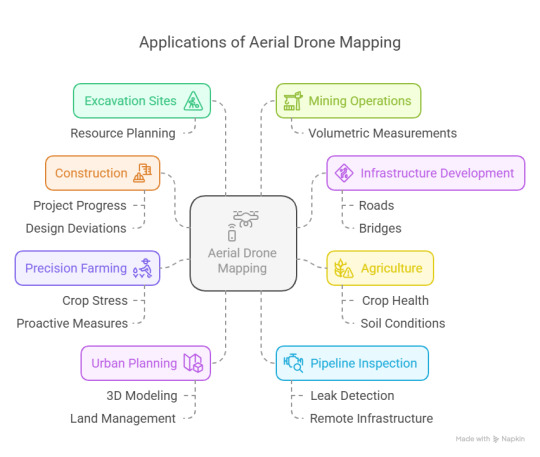
Key Industry Applications of Drone Mapping
Aerial drone mapping is now a vital resource across several industries:
• Construction – Monitor project progress, perform site analysis, and identify design deviations.
• Infrastructure Development – Plan roads, bridges, and utilities with accurate terrain data.
• Agriculture – Evaluate crop health, monitor irrigation patterns, and improve yield with precision farming.
• Mining – Conduct volumetric measurements and monitor excavation sites for efficient resource planning.
• Urban Planning – Generate 3D models for land use planning, zoning, and city expansion.
• Utilities and Energy – Inspect pipelines, transmission lines, and other critical infrastructure in hard-to-reach areas.
Elevate Your Projects with Drone Technology Aerial drone mapping is not just a trend—it’s a transformative tool shaping the future of surveying, agriculture, and infrastructure development. From precise geospatial data collection to rapid project assessment, drones are delivering unprecedented value.
Ready to transform your mapping, surveying, or farming practices? Contact Agri Drone Specialists today at 027 323 8155 or email [email protected] to learn how drone solutions can elevate your operations.
#Aerial Drone Mapping#Aerial spraying drone#Drone#drone mapping#drone mapping services#Drone Services
0 notes
Text
Top 10 GIS Use Cases Across
Geographic Information Systems (GIS) have become an indispensable tool across various industries, offering powerful solutions to complex problems by integrating spatial data with analytical capabilities. Whether you’re in architecture, government, or health services, GIS provides unique insights that drive decision-making, efficiency, and innovation. In this blog, we’ll explore the top 10 GIS use cases for 18 different industries, showcasing the transformative impact of geospatial technology.
Architecture, Engineering & Construction
1. Site Selection & Analysis: Choosing the right site for a construction project is critical. GIS allows architects and engineers to analyze various factors such as topography, soil type, zoning regulations, and environmental constraints, ensuring the best possible location for development.
2. Infrastructure Management: Managing infrastructure such as roads, bridges, and utilities is simplified with GIS. It provides a real-time view of assets, helping engineers to monitor conditions, plan maintenance, and ensure compliance with safety standards.
3. 3D Modeling & Visualization: GIS enables the creation of 3D models that help in visualizing urban developments, construction projects, and architectural designs. These models provide a realistic view of how new structures will fit into the existing environment.
4. Environmental Impact Assessments: Before any construction begins, assessing the environmental impact is crucial. GIS helps in identifying potential risks to ecosystems, water sources, and communities, allowing for mitigation strategies to be put in place.
5. Construction Project Management: With GIS, managing large construction projects becomes more efficient. Project managers can track progress, allocate resources, and monitor timelines through spatial data integration.
6. Utilities Design & Mapping: Designing and mapping utilities such as water, gas, and electricity require precision. GIS ensures that all utilities are correctly planned and placed, avoiding costly errors during construction.
7. Urban Planning: Urban planning benefits immensely from GIS by providing a comprehensive view of city layouts, zoning laws, and population density. This data is essential for creating sustainable and efficient urban environments.
8. Flood Risk Assessment: Flood risks can be assessed using GIS, which analyzes historical flood data, topography, and climate patterns to identify areas at risk. This information is vital for planning resilient infrastructures.
9. Surveying & Land Development: GIS is revolutionizing the way land surveys are conducted. It allows for the precise mapping of land parcels, helping developers to plan and execute projects more efficiently.
10. Building Information Modeling (BIM): Integration Integrating GIS with BIM provides a powerful tool for architects and engineers. It enhances spatial analysis, offering a more comprehensive approach to construction planning and management.
Business
1. Market Analysis & Site Selection: GIS helps businesses identify optimal locations for expansion by analyzing demographics, customer behavior, and competitor locations. This data-driven approach ensures that businesses choose sites that maximize profitability.
2. Supply Chain Optimization: In the world of logistics, GIS plays a critical role in optimizing supply chains. It helps businesses map out the most efficient routes, reducing costs and delivery times.
3. Customer Segmentation: Understanding customer demographics is key to targeted marketing. GIS allows businesses to map customer locations and behavior, enabling more personalized marketing strategies.
4. Sales Territory Management: GIS assists in defining and managing sales territories by analyzing geographic data. This ensures that sales teams are deployed effectively, maximizing coverage and performance.
5. Competitor Analysis: GIS provides businesses with a competitive edge by mapping competitor locations and analyzing market share. This information is crucial for strategic planning and market entry.
6. Real Estate Analysis: In real estate, location is everything. GIS helps businesses analyze property values, market trends, and zoning laws, aiding in informed decision-making.
7. Risk Management: Businesses face various risks related to their geographic locations, such as natural disasters or political instability. GIS helps in assessing and mitigating these risks by providing detailed spatial analysis.
8. Advertising & Marketing: Targeted advertising is more effective when it considers geographic factors. GIS allows businesses to plan marketing campaigns based on location data, ensuring that they reach the right audience.
9. Franchise Expansion For businesses looking to expand through franchising, GIS provides insights into the best locations for new outlets. It considers factors like population density, income levels, and competitor presence.
10. Workforce Management Managing a geographically dispersed workforce is challenging. GIS helps businesses monitor employee locations, optimize routes, and ensure that resources are allocated efficiently.
Conservation
1. Habitat Mapping & Monitoring: GIS is a powerful tool for conservationists, allowing them to map and monitor critical habitats. This helps in protecting endangered species and managing biodiversity.
2. Species Distribution Modeling: Understanding where species are located and how they move is essential for conservation efforts. GIS enables the modeling of species distribution, helping in the creation of effective conservation strategies.
3. Protected Area Management: Managing protected areas requires detailed spatial information. GIS provides conservationists with the tools to monitor and manage these areas, ensuring that they remain protected.
4. Environmental Impact Assessments: Before any development occurs in sensitive areas, environmental impact assessments are necessary. GIS helps in identifying potential risks and developing strategies to mitigate them.
5. Land Use Planning: GIS supports sustainable land use planning by providing data on topography, soil types, and existing land use. This helps in making informed decisions that balance development and conservation.
6. Water Resource Management: Water is a critical resource for conservation. GIS helps in monitoring and managing watersheds, ensuring that water resources are protected and sustainably managed.
7. Climate Change Analysis: Climate change poses significant risks to ecosystems. GIS helps in analyzing these risks by modeling the impact of climate change on various habitats and species.
8. Restoration Planning: Restoring degraded habitats requires careful planning. GIS helps in identifying areas that need restoration and in monitoring the progress of restoration efforts.
9. Wildlife Corridor Mapping: GIS is used to identify and protect wildlife corridors, which are essential for the migration of species. This helps in maintaining genetic diversity and ecosystem health.
10. Natural Resource Management: Conservation efforts often involve managing natural resources such as forests and water bodies. GIS provides the tools needed to monitor and manage these resources effectively.
Education
1. Campus Mapping GIS allows educational institutions to create detailed campus maps, helping students, staff, and visitors navigate the campus with ease.
2. Student Demographic Analysis: Understanding student demographics is essential for educational planning. GIS helps institutions analyze where students are coming from, allowing for more targeted recruitment and support.
3. Curriculum Development: GIS can be integrated into various subjects, such as geography and environmental science, providing students with hands-on experience in spatial analysis.
4. Research Support: GIS supports academic research by providing tools for spatial analysis. This is particularly useful in fields such as environmental science, urban planning, and public health.
5. Resource Allocation: Educational institutions often face challenges in allocating resources effectively. GIS helps in analyzing the geographic distribution of students and resources, ensuring that they are allocated where they are needed most.
6. Community Outreach: Educational institutions often engage in community outreach programs. GIS helps in mapping out these programs, ensuring that they reach the communities that need them most.
7. Environmental Education: GIS provides a powerful tool for teaching students about the environment. It allows them to explore real-world data and understand the impact of human activities on the environment.
8. Alumni Tracking: GIS helps institutions track alumni, understanding where they are located and how they are contributing to their communities. This information is valuable for engagement and fundraising efforts.
9. Field Studies: Field studies are an essential part of many educational programs. GIS allows students to collect and analyze spatial data in the field, providing them with practical experience.
10. Emergency Planning: Educational institutions need to be prepared for emergencies. GIS helps in developing emergency response plans by providing detailed maps of the campus and surrounding areas.
Energy Utilities
1. Asset Management: Energy utilities have vast networks of assets, including power lines, substations, and pipelines. GIS helps in tracking and managing these assets, ensuring that they are maintained and operating efficiently.
2. Network Planning: Planning and designing utility networks requires detailed spatial analysis. GIS helps in optimizing the placement of new infrastructure, reducing costs, and improving service delivery.
3. Outage Management: When outages occur, utilities need to respond quickly. GIS provides real-time data on the location and extent of outages, helping utilities to restore service as quickly as possible.
4. Environmental Compliance: Energy utilities are subject to strict environmental regulations. GIS helps in monitoring compliance by providing data on the impact of utility operations on the environment.
5. Renewable Energy: Renewable energy sources such as wind and solar require precise site selection. GIS helps in identifying the best locations for renewable energy projects, considering factors such as sunlight, wind speed, and proximity to the grid.
6. Smart Grid: The smart grid is revolutionizing the way utilities deliver electricity. GIS plays a critical role in managing the smart grid by providing data on the location of smart meters, sensors, and other infrastructure.
7. Disaster Response: When natural disasters occur, energy utilities need to respond quickly to restore service. GIS helps in coordinating disaster response efforts by providing real-time data on the location and extent of damage.
8. Energy Demand Forecasting: Accurately forecasting energy demand is essential for ensuring that supply meets demand. GIS helps in analyzing factors such as population growth and economic activity, providing utilities with the data they need to forecast demand accurately.
9. Customer Engagement: Energy utilities need to engage with their customers, providing them with information on energy usage and efficiency. GIS helps in mapping out customer locations and tailoring engagement strategies to meet their needs.
10. Risk Management: Energy utilities face a variety of risks, including natural disasters, cyberattacks, and regulatory changes. GIS helps in assessing and mitigating these risks by providing detailed spatial analysis.
Facilities Management
1. Space Utilization: Managing space efficiently is a key challenge for facility managers. GIS helps in analyzing space utilization, identifying areas that are underused, and optimizing layouts.
2. Maintenance Management: GIS supports maintenance management by providing detailed maps of facilities and their assets. This helps in planning and scheduling maintenance tasks, ensuring that assets are kept in good condition.
3. Energy Management: Facility managers need to monitor and manage energy usage to reduce costs and environmental impact. GIS helps in analyzing energy usage patterns and identifying opportunities for efficiency improvements.
4. Emergency Planning: In the event of an emergency, facility managers need to respond quickly. GIS provides detailed maps of facilities, helping to develop and implement emergency response plans.
5. Asset Tracking: Facility managers are responsible for a wide range of assets, from furniture to HVAC systems. GIS helps in tracking these assets, ensuring that they are properly maintained and replaced when necessary.
6. Space Planning: GIS supports space planning by providing detailed maps of facilities and their layouts. This helps in optimizing the use of space, ensuring that it meets the needs of occupants.
7. Security Management: Facility security is a top priority for facility managers. GIS helps in monitoring and managing security systems, ensuring that facilities are protected from unauthorized access.
8. Environmental Compliance: Facility managers need to ensure that their facilities comply with environmental regulations. GIS helps in monitoring compliance by providing data on the impact of facility operations on the environment.
9. Fleet Management: For facilities with vehicle fleets, GIS helps in managing and optimizing fleet operations. This includes route planning, vehicle tracking, and maintenance scheduling.
10. Space Allocation: Allocating space effectively is essential for ensuring that facilities meet the needs of occupants. GIS helps in analyzing space requirements and allocating space based on usage patterns.
Health & Human Services
1. Disease Surveillance and Outbreak Management: GIS is crucial in tracking and managing disease outbreaks. By mapping the spread of diseases, health officials can identify hotspots, monitor trends, and allocate resources effectively to contain the spread.
2. Health Resource Allocation: GIS helps in analyzing the geographic distribution of health resources, such as hospitals, clinics, and pharmacies. This ensures that health services are accessible to the population, particularly in underserved areas.
3. Epidemiology and Public Health Research: GIS is used extensively in epidemiological studies to analyze the spatial patterns of health events. This helps in understanding the relationships between environmental factors and health outcomes, guiding public health interventions.
4. Emergency Response and Preparedness: In disaster situations, GIS is critical for coordinating emergency response efforts. It helps in mapping affected areas, identifying safe zones, and deploying resources where they are most needed.
5. Health Service Planning: GIS aids in the planning of health services by analyzing population demographics, health needs, and service availability. This ensures that health services are planned and delivered where they are most needed.
6. Environmental Health Monitoring: GIS helps in monitoring environmental factors that affect health, such as air and water quality. This data is crucial for assessing health risks and implementing public health measures.
7. Accessibility and Equity in Healthcare: GIS is used to analyze the accessibility of healthcare services across different regions, helping to identify disparities in service provision and guide efforts to improve equity.
8. Social Services Delivery: For human services, GIS supports the planning and delivery of services like child welfare, senior care, and food assistance programs, ensuring these services reach those in need.
9. Behavioral Health and Substance Abuse Treatment: GIS is increasingly being used to map and analyze the availability and accessibility of behavioral health services and substance abuse treatment centers. This helps in identifying gaps in service provision and directing resources to areas with the greatest need.
10. Telehealth Expansion and Planning: With the rise of telehealth, GIS is used to map and analyze broadband availability and identify regions where telehealth services can be expanded.
National Government
1. National Security and Defense: GIS is used for military planning, logistics, and operations. It helps in mapping terrain, planning missions, and monitoring threats, ensuring that national security is maintained.
2. Disaster Management: National governments rely on GIS for disaster preparedness, response, and recovery. It helps in mapping vulnerable areas, coordinating response efforts, and assessing damage after disasters.
3. Policy Development and Implementation: GIS provides valuable data for the development and implementation of national policies. Whether it’s infrastructure development, environmental protection, or economic planning, GIS ensures that policies are data-driven and geographically sound.
4. Natural Resource Management: Managing a nation’s natural resources, such as forests, water, and minerals, requires detailed spatial analysis. GIS helps in monitoring and managing these resources sustainably.
5. Census and Population Studies: National governments use GIS for conducting censuses and population studies. It helps in mapping population distribution, analyzing demographic trends, and planning services accordingly.
6. Infrastructure Development: GIS is crucial in the planning and development of national infrastructure, including roads, bridges, and utilities. It ensures that infrastructure projects are efficiently planned and executed.
7. Environmental Protection: National governments use GIS to monitor and protect the environment. It helps in tracking deforestation, pollution, and wildlife populations, ensuring that conservation efforts are effective.
8. Public Safety: GIS supports public safety initiatives by mapping crime patterns, planning law enforcement operations, and ensuring that emergency services are optimally located and deployed.
9. Transportation Planning: GIS is used for planning and managing national transportation networks, ensuring that roads, railways, and airports are efficiently planned and maintained.
10. Land Use and Zoning: GIS supports national governments in land use planning and zoning, ensuring that land is used efficiently and sustainably across the country.
Natural Resources
1. Resource Exploration: GIS is a powerful tool for natural resource exploration, helping companies identify potential sites for mining, drilling, and other activities.
2. Environmental Impact: Assessments Before any resource extraction occurs, environmental impact assessments are necessary. GIS helps in identifying potential risks and developing strategies to mitigate them.
3. Land Use Planning: Managing natural resources requires detailed spatial analysis. GIS helps in analyzing land use patterns and developing sustainable management strategies.
4. Water Resource Management: Water is a critical resource for many industries. GIS helps in monitoring and managing watersheds, ensuring that water resources are protected and sustainably managed.
5. Forestry Management: Managing forests requires detailed spatial data. GIS helps in monitoring forest health, planning timber harvests, and protecting wildlife habitats.
6. Wildlife Management: Managing wildlife populations requires detailed spatial analysis. GIS helps in tracking animal movements, monitoring populations, and protecting critical habitats.
7. Environmental Monitoring: Monitoring the environment is a critical function of natural resource management. GIS helps in tracking air and water quality, monitoring deforestation, and managing natural resources.
8. Land Degradation Monitoring: Land degradation is a significant problem for natural resource management. GIS helps in monitoring land degradation and developing strategies to combat it.
9. Oil & Gas Exploration: Exploring for oil and gas requires detailed spatial analysis. GIS helps in identifying potential drilling sites, optimizing exploration efforts, and minimizing environmental impact.
10. Sustainable Development: Sustainable development requires a balance between resource extraction and environmental protection. GIS helps in analyzing these factors and developing sustainable management strategies.
Conclusion
At Advintek Geoscience, we specialize in providing cutting-edge GIS solutions tailored to meet the unique needs of your industry. Our expertise ensures that you harness the full potential of GIS to achieve your goals, whether you’re improving public health, managing natural resources, or advancing business.
Ready to elevate your operations with advanced GIS solutions? Visit Advintek Geoscience to learn more about how we can help you integrate GIS into your workflow, or contact us today to discuss how we can support your specific needs.
0 notes
Text
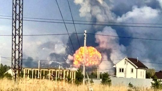
Ukraine war latest: Explosions rock what could be one of Russia's largest weapons arsenals in Vladimir Oblast
Key developments on April 22:
Explosions rock what could be one of Russia’s largest weapons arsenals in Vladimir Oblast
Putin offers US to freeze Ukraine war along current front line, FT reports
Zelensky rules out recognizing Crimea as Russian, warns against playing into Putin’s ‘game’
Russia used Easter truce to regroup in Lyman sector, launched offensive after, military says
Japan to provide Ukraine with geospatial intelligence, media reports
Explosions have erupted at a Russian weapons arsenal in Vladimir Oblast on April 22, causing a fire, the Russian Defense Ministry reported on Telegram.
According to Ukrainian defense media outlet Militarnyi, the facility in question is Russia’s 51st Arsenal of the Main Missile and Artillery Directorate – one of Russia’s largest weapons arsenals, located about 530 kilometers (330 miles) from the Ukrainian border.
The Kyiv Independent could not verify the claims.
According to the Russian Defense Ministry, the fire erupted at the site due to a violation of safety protocols when working with explosive materials. No casualties have been reported.
Russian Defense Minister Andrei Belousov has ordered the creation of a special commission to investigate the incident.
The Russian Emergencies Ministry reported that a military unit, seven settlements, and 12 holiday villages had been evacuated due to the incident.
Independent Russian media outlet ASTRA reported, citing local residents, a powerful blast at the base, followed by continued secondary detonations.
Following the incident, roads leading to the nearby town of Kirzhach from Moscow were closed. According to Russian state-controlled media outlet Kommersant, Russian authorities ordered evacuations from the settlements of Barsovo and Mirny.
Explosions reported near military base in Kirzhachsky district, Vladimir region — local media A road leading from Moscow to Kirzhach has reportedly been blocked. Residents say smoke from the explosions can be seen above the village of Barsovo. The area houses the Arsenal of the… pic.twitter.com/H1soMmk1R4
— ASTRA (@ASTRA_PRESS) April 22, 2025
Vladimir Oblast Governor Alexander Avdeev confirmed the explosions but warned journalists and residents against spreading information about the incident before "verified official data" is released, threatening fines for violations.
Analysis of imagery from the facility suggests that the arsenal stored a wide range of weapons, including medium-caliber artillery shells and missiles for anti-aircraft systems, Militarnyi reported.
According to Militarnyi, the facility also housed a laboratory for monitoring the condition of artillery propellants and explosives, as well as workshops equipped to test high-tech weapons systems.
In addition to specialized equipment, the 51st Arsenal and similar bases under the Main Missile and Artillery Directorate are believed to store large stockpiles of heavy artillery shells, munitions for multiple launch rocket systems (MLRS), and small arms ammunition.
The facility has a history of similar incidents. On June 22, 2022, a detonation of ammunition occurred during unloading operations, killing three servicemen and a civilian specialist and seriously injuring another.
Russian bombs kill 1, injure 23 in Zaporizhzhia amid Kyiv’s calls for civilian infrastructure truce
Russian forces attacked the city at around 11:40 a.m. with two KAB bombs, with one hitting an infrastructure facility and another a multi-story residential building in Zaporizhzhia’s residential neighborhood, Governor Ivan Fedorov said.

The Kyiv IndependentKateryna Hodunova

Putin offers US to freeze Ukraine war along current front line, FT reports
Russian President Vladimir Putin has offered the U.S. to halt his full-scale invasion of Ukraine along the current front line, the Financial Times (FT) reported on April 22, citing unnamed sources familiar with the talks.
Putin reportedly conveyed the offer during a recent meeting with U.S. Special Envoy Steve Witkoff in St. Petersburg. This could be the first formal indication from Putin since the full-scale war began in 2022 that Russia may consider scaling back its territorial demands.
Kremlin spokesperson Dmitry Peskov, responding to the report, cast doubt on its accuracy. "A lot of fakes are being published now, including those published by respected publications, so one should only listen to primary sources," he told the Russian state-controlled media outlet RIA Novosti.
Russia illegally declared ownership over Ukraine's Crimea in 2014 and over Zaporizhzhia, Kherson, Donetsk, and Luhansk oblasts in 2022, in violation of international law. Russia only partially occupies the four oblasts.
Moscow has repeatedly demanded international recognition of the regions as Russian and that Ukrainian troops completely withdraw from them as part of any peace negotiations.
Putin's message reportedly prompted Washington to propose a "peace settlement," elements of which have since been revealed in media reports, according to the FT.
According to the Wall Street Journal, the U.S. proposal — presented in a confidential April 17 meeting in Paris — involves potentially recognizing Russia's annexation of Crimea and barring Ukraine from NATO membership.
Ukraine has been asked to respond this week, with a follow-up meeting scheduled in London on April 23 involving delegations from Ukraine, the U.S., the U.K., and France. If the parties reach a consensus, the proposal may be formally introduced to Moscow.
European officials cited by the FT expressed concern that Putin's offer is designed to push U.S. President Donald Trump toward accepting broader Kremlin demands.
Witkoff, who conveyed Putin's position and is expected to visit Moscow this week, has drawn criticism for backing proposals perceived as aligning with Russian interests.
Washington has signaled that if no progress is made in the coming days, it may abandon its ceasefire mediation efforts.
‘Territories are first and foremost people:’ Zaporizhzhia, Kherson residents anxiously watch Witkoff debate the land they live on
Zaporizhzhia — During what would usually be evening rush hour in Zaporizhzhia, cars move easily through main streets that were once choked with traffic. As the shadows grow longer, soldiers calmly remove camouflage netting from the air defense weapons they’ll man against Russia’s deadly attacks until the sun rises
The Kyiv IndependentAndrea Januta

Zelensky rules out recognizing Crimea as Russian, warns against playing into Putin's 'game'
Ukraine will not legally recognize Russia's occupation of Crimea under any circumstances, President Volodymyr Zelensky said during a briefing in Kyiv on April 22.
"There is nothing to talk about. This violates our Constitution. This is our territory, the territory of the people of Ukraine," the president told reporters.
Zelensky warned that any discussion of Crimea risks shifting negotiations into a framework dictated by the Kremlin. He said such proposals play directly into Russian President Vladimir Putin's "game."
"As soon as talks about Crimea and our sovereign territories begin, the talks enter the format that Russia wants — prolonging the war – because it will not be possible to agree on everything quickly," he added.
While acknowledging that signals about Crimea have surfaced in different channels, Zelensky said Ukraine would reject immediately any official proposal.
"We know where these signals are sounding and will continue to sound," he said, adding that he was unsure whether they originated from Russia or certain U.S. representatives engaged in dialogue with Putin.
Join our community
Support independent journalism in Ukraine. Join us in this fight.
Support Us

On April 14, U.S. Special Envoy Steve Witkoff told Fox News that a potential peace deal could center on the status of five territories.
While he did not name them explicitly, he is believed to be referring to Crimea, illegally annexed by Russia in 2014, along with the partially occupied regions of Donetsk, Luhansk, Zaporizhzhia, and Kherson.
Zelensky said the Ukrainian delegation going to London will have a mandate to discuss terms for a full or partial ceasefire with Russia. Ukraine is ready to negotiate with Russia in any format but only after an unconditional halt to hostilities, he added.
Zelensky also stressed that sustained international pressure — especially from the United States — is necessary to reach a meaningful settlement.
"We've been at war for over 11 years," Zelensky said. "Is it possible to reach an agreement with Russia quickly? No, it is not. It is impossible without pressure."
Despite expressing frustration over Russia's refusal to de-escalate the war, U.S. President Donald Trump has so far avoided imposing any major sanctions or taking punitive action against Moscow.
Trump hopes to ‘end war’ this week. Here’s what you need to know
U.S. President Donald Trump declared that Russia and Ukraine could reach a war-ending deal “this week,” as his team threatens that Washington could ditch the peace talks efforts if no step is taken in the near future. “Both will then start to do big business with the United States
The Kyiv IndependentAsami Terajima

Russia used Easter truce to regroup in Lyman sector, launched offensive after, military says
Russian forces in the Lyman sector of Donetsk Oblast violated the one-day Easter ceasefire, used it to regroup, and launched a large-scale infantry assault shortly after its end, Anastasiia Blyshchyk, spokesperson for Ukraine's 66th Separate Mechanized Brigade, told Suspilne media on April 22.
Russian President Vladimir Putin declared a symbolic one-day ceasefire on April 19, which President Volodymyr Zelensky said was violated around 3,000 times.
"This so-called truce did more damage to us," Blyshchyk said. "A few hours after Putin announced the ceasefire, our positions came under massive artillery fire."
According to the spokesperson, Russian forces exploited the lull to reposition units and prepare for renewed assaults.
"We saw them pulling up their infantry to the front line along with weapons, including rocket-propelled grenade launchers and machine guns," she said.
"Our aerial reconnaissance recorded more than 120 Russian occupiers dispersing in plantations, forest belts, destroyed buildings, and dugouts during the so-called Easter truce."
Blyshchyk added that once the truce ended, Russian forces launched a large-scale infantry offensive.
The Lyman sector in northern Donetsk Oblast remains one of the most fiercely contested areas along the front line. Its strategic importance lies in its proximity to key transport routes and logistics corridors.
The assault follows statements from Ukrainian military leadership that Russia's anticipated spring offensive is already underway.
On April 9, Commander-in-Chief Oleksandr Syrskyi confirmed that Moscow had begun its spring campaign, with intensified attacks across multiple sectors of the front line.
Our readers’ questions about the war, answered. Vol. 8
Editor’s note: We asked members of the Kyiv Independent community to share the questions they have about the war. Here’s what they asked and how we answered. Join our community to ask a question in the next round. Question: Is Ukraine formulating a plan to receive and house refugees from
The Kyiv IndependentThe Kyiv Independent

Japan to provide Ukraine with geospatial intelligence, media reports
Japan's Kyushu University Institute for Q-shu Pioneers of Space (iQPS) has agreed to provide Ukraine's military intelligence agency (HUR) with synthetic aperture radar (SAR) imagery, Intelligence Online magazine reported on April 21.
Japanese and Ukrainian authorities reportedly began discussing possible support in February, with the talks gaining urgency after the U.S. temporarily paused intelligence assistance for Kyiv in early March.
iQPS, which plans to launch its seventh SAR observation satellite by late 2026, agreed with Kyiv on a timeline of two to three months to install relevant software onto Ukrainian intelligence's platforms, the magazine wrote.
The Kyiv Independent could not immediately verify the claims.
SAR technology, which can recreate two-dimensional or three-dimensional images of landscapes or objects, has broad military applications. It can help track enemy movement and installations regardless of weather conditions.
Ukraine receives intelligence support from other partners, including France and the U.K. Nevertheless, the U.S.-imposed pause underscored its critical role in military planning, namely in launching long-range strikes and intercepting Russian aerial attacks.
Washington claimed its halt on intelligence support, which coincided with the freezing of arms supplies, extended only to offensive operations. While the U.S. resumed the assistance after progress in ceasefire talks, the move ramped up concerns about further cuts in the future.
Ukraine's military heavily relies on Starlink, a communications system owned by Elon Musk, U.S. President Donald Trump's close ally and critic of military aid to Kyiv. French satellite operator Eutelsat pledged to scale up its operations in Ukraine but said it could not currently replace the 50,000 Starlink terminals operating in the country.
Note from the author:
Ukraine War Latest is put together by the Kyiv Independent news desk team, who keep you informed 24 hours a day, seven days a week. If you value our work and want to ensure we have the resources to continue, join the Kyiv Independent community.
youtube
0 notes
Text
A GIS-Based Approach to Infrastructure and Road Network Planning
Geographic Information Systems (GIS) offer a powerful platform for infrastructure development by enabling detailed spatial analysis, route optimization, and long-term urban planning. Through advanced mapping, terrain modeling, and data integration, GIS improves the efficiency, sustainability, and connectivity of transportation systems.
Why Use GIS for Infrastructure and Road Network Development? GIS provides planners and engineers with accurate, data-driven insights into land use, topography, and population density. It reduces development costs, enhances route planning, and ensures infrastructure aligns with environmental and social needs. This approach also supports transparent decision-making and continuous project monitoring.

GIS in Road Network Analysis Supports:
Spatial Planning: Analyzing terrain and land cover to determine optimal routes and avoid natural obstacles.
Traffic Flow Analysis: Using temporal traffic data to identify bottlenecks and improve route efficiency.
Environmental Assessment: Minimizing environmental impact by avoiding sensitive zones during construction planning.
Infrastructure Lifecycle Management: Enabling long-term monitoring and maintenance scheduling of road networks.
Using GIS for Infrastructure Mapping Includes:
Uploading and styling road and terrain layers.
Using elevation and slope data to design roads in complex topography.
Buffering critical areas (e.g., schools, rivers) for risk-aware planning.
Integrating socio-economic datasets for inclusive infrastructure design.
Procedure for Infrastructure Mapping and Road Network Analysis Using GIS
Road network analysis using GIS begins with acquiring and preparing data on traffic, fuel consumption, emissions, and environmental conditions. Administrative boundaries and road network layers are added and styled for better visualization. Buffer zones are created around current and proposed highways to assess impact areas. Spatial joins integrate land ownership, zoning, and environmental data. A multi-criteria analysis is then conducted to identify the most suitable road alignment. The results are compiled into a geospatial report for informed planning and stakeholder input.
Use Case: Urban Expansion and Road ConnectivityGIS helps urban planners overlay demographic data with existing transport networks to identify underserved areas and prioritize road expansions, promoting equitable access, economic growth, and reduced congestion.
Open-source GIS Mapping for Road Networks Open-source tools like MAPOG enable detailed, multi-layered infrastructure mapping with features like route tracking, real-time updates, and spatial analysis. These platforms empower planners to build smarter cities with sustainable mobility systems and increased public engagement.
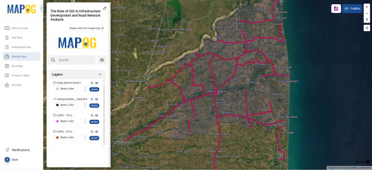
Conclusion Buffer zones and route analytics improve the precision of infrastructure projects. When used effectively, GIS supports proactive planning, better transport access, and reduced development risks across urban and rural areas.
#InfrastructureMapping#RoadNetworkPlanning#UrbanMobility#GISinInfrastructure#GeospatialTech#SmartCities#SmartMapping#DataDrivenPlanning#TransportationInnovation
1 note
·
View note
Text
Africa GNSS Market Competitive Landscape and Strategic Insights to 2033
Introduction
Global Navigation Satellite System (GNSS) technology has seen widespread adoption across multiple industries, including agriculture, transportation, logistics, and surveying. Africa’s GNSS market is poised for significant growth, driven by increased demand for precision positioning services, infrastructure development, and government initiatives. This article explores industry trends, key drivers, challenges, and the forecast for the African GNSS market leading up to 2032.
Market Overview
The African GNSS market is still developing but has seen notable adoption due to advancements in satellite technology, improved internet connectivity, and increasing investments in smart infrastructure. GNSS technology is used in various applications, such as land surveying, geospatial mapping, precision agriculture, fleet management, and urban planning.
𝗗𝗼𝘄𝗻𝗹𝗼𝗮𝗱 𝗮 𝗙𝗿𝗲𝗲 𝗦𝗮𝗺𝗽𝗹𝗲 𝗥𝗲𝗽𝗼𝗿𝘁👉https://tinyurl.com/4t3cfe5v
Key Market Drivers
Infrastructure Development
Many African countries are investing in large-scale infrastructure projects, such as smart cities, road networks, and railway systems, which require precise geolocation services.
Agricultural Advancements
Precision farming using GNSS technology helps optimize resource utilization, improve yield, and reduce operational costs. With Africa’s agrarian economy, GNSS adoption in farming is growing rapidly.
Rising Demand for Location-Based Services (LBS)
The expansion of mobile technology and navigation-based applications has increased demand for GNSS-enabled services. This includes ride-hailing apps, logistics tracking, and emergency response systems.
Government Initiatives and Policies
Governments across Africa are implementing policies to integrate GNSS in national development plans. Programs supporting satellite navigation, mapping, and disaster management are being developed.
Improvement in Satellite Infrastructure
The deployment of regional satellite navigation systems and the use of international GNSS systems such as GPS, Galileo, and BeiDou enhance the reliability of positioning services in Africa.
Key Market Challenges
Limited Infrastructure
While urban areas have made strides in adopting GNSS, rural and remote regions still lack the necessary infrastructure to support GNSS applications effectively.
High Costs of GNSS Equipment and Services
The cost of acquiring and maintaining GNSS receivers, software, and subscription services can be a significant barrier for small-scale users.
Technical and Skills Gaps
The lack of skilled professionals in GNSS technology and applications presents a challenge to market growth. Capacity-building initiatives are needed to bridge this gap.
Regulatory and Policy Constraints
The absence of harmonized policies and regulatory frameworks across different African nations creates inconsistencies in GNSS implementation and usage.
Market Segmentation
The African GNSS market can be segmented based on application, end-user industry, and geographic region.
By Application
Navigation and Mapping: Used in urban planning, disaster management, and surveying.
Agriculture: Supports precision farming, yield monitoring, and automated machinery.
Transportation and Logistics: Fleet management, traffic control, and intelligent transport systems.
Defense and Security: Border control, surveillance, and emergency response.
Construction and Mining: Site surveying, resource tracking, and safety management.
By End-User Industry
Agriculture
Transportation and Logistics
Government and Defense
Construction and Mining
Telecommunications
Healthcare (emergency response services)
By Geography
North Africa (Egypt, Algeria, Morocco, Tunisia)
West Africa (Nigeria, Ghana, Senegal, Ivory Coast)
East Africa (Kenya, Ethiopia, Tanzania, Uganda)
Southern Africa (South Africa, Angola, Zambia, Zimbabwe)
Central Africa (DR Congo, Cameroon, Chad)
Competitive Landscape
The African GNSS market is composed of international players and emerging local service providers. Key companies operating in the space include:
Trimble Inc.
Hexagon AB
Garmin Ltd.
Topcon Corporation
Septentrio NV
Fugro N.V.
ComNav Technology Ltd.
South Instruments
These players are investing in research and development, strategic partnerships, and collaborations to expand their presence in Africa.
Future Trends and Market Outlook (2024-2032)
Expansion of Local GNSS Services
Countries like South Africa, Nigeria, and Kenya are expected to enhance their GNSS infrastructure and develop local navigation services.
Integration with Emerging Technologies
GNSS will be increasingly integrated with AI, IoT, and 5G networks to improve accuracy and automation in industries such as smart agriculture and autonomous transportation.
Growing Adoption of GNSS in Disaster Management
With climate change concerns, African nations will leverage GNSS technology for early warning systems, flood monitoring, and crisis response.
Increase in Public-Private Partnerships (PPPs)
Collaborations between governments, private firms, and international organizations will accelerate GNSS adoption and infrastructure development.
Rise in Affordable GNSS Solutions
Cost-effective GNSS solutions tailored for the African market are expected to increase accessibility and adoption among small businesses and local enterprises.
Conclusion
The Africa GNSS market is set for significant expansion over the next decade, driven by infrastructure projects, increased demand for precision-based applications, and government support. Despite challenges such as high costs and regulatory issues, ongoing developments in satellite infrastructure, training programs, and local service provisions will foster growth. With key players investing in innovation and strategic collaborations, Africa’s GNSS ecosystem is poised to become a crucial component of the continent’s digital transformation and economic development.
Read Full Report:-https://www.uniprismmarketresearch.com/verticals/information-communication-technology/africa-gnss.html
0 notes
Text
Exploring 2021 GPS Projects in Chennai
Chennai, a dynamic city known for its technological advancements and vibrant educational landscape, has become a hub for various research and development initiatives, particularly in the field of Geographic Information Systems (GIS) and Global Positioning Systems (GPS). The year 2021 witnessed a surge in innovative GPS projects in Chennai, thanks to the city’s blend of academic institutions, research centers, and thriving tech industry. These projects have significantly contributed to advancements in navigation, logistics, and urban planning, shaping the future of smart cities and geospatial technologies.
The Role of GPS Technology in 2021
GPS technology plays a critical role in a wide array of sectors, ranging from transportation and logistics to agriculture and environmental monitoring. In 2021, Chennai saw numerous projects exploring the various facets of GPS applications. Research institutions, universities, and companies in the city have been utilizing GPS to develop cutting-edge solutions that improve efficiency, enhance safety, and optimize resource utilization.
One of the prominent areas of development for 2021 GPS projects in Chennai involved the integration of GPS with Internet of Things (IoT) devices. These projects were aimed at enhancing real-time tracking of assets, vehicles, and personnel. With a focus on sectors such as logistics, fleet management, and delivery services, the goal was to build systems that could provide precise location data, optimize routes, and improve service delivery.
Applications in Smart City Development
Chennai has also been at the forefront of leveraging GPS technology in the development of smart cities. In 2021, several projects aimed at improving urban infrastructure were implemented using GPS data. For instance, projects related to traffic management used GPS to monitor and manage traffic flow in real-time, reduce congestion, and optimize public transportation systems. The data collected through GPS sensors allowed city planners to design smarter roads, better transportation networks, and more efficient resource allocation.
Additionally, GPS-based projects in waste management became increasingly popular in Chennai. By integrating GPS with waste collection vehicles, the city was able to track routes, monitor collection efficiency, and reduce carbon footprints—helping to move towards more sustainable urban living.
GPS in Agriculture and Environmental Monitoring
In 2021, Chennai-based researchers also applied GPS technology to agricultural projects, focusing on precision farming. GPS-guided systems enabled farmers to monitor soil health, automate irrigation, and track crop growth, leading to more efficient and sustainable agricultural practices.
Environmental monitoring projects also saw significant use of GPS in 2021. Researchers used GPS technology to track and analyze changes in the environment, such as monitoring coastal erosion or mapping water bodies, to facilitate better decision-making in environmental conservation.
Conclusion
The 2021 GPS projects in Chennai marked a significant leap forward in various industries, from urban planning and logistics to agriculture and environmental science. With its strategic location and strong presence of educational and research institutions, Chennai continues to be a center for innovation, driving the development of GPS-based solutions that will shape the future of technology, smart cities, and sustainability. As the demand for precise geospatial data grows, the city’s contributions to GPS technology will continue to be pivotal in tackling some of the world’s most pressing challenges.
0 notes
Text
Advancing Highway Construction with Cutting-Edge Engineering Solutions
Highways serve as the arteries of modern economies, facilitating the efficient transportation of goods, services, and people across cities, states, and nations. However, the construction and maintenance of these critical infrastructures have long presented logistical, environmental, and safety challenges. Williams Brothers Construction Company, Inc. leads highway development, utilizing innovative engineering solutions to improve efficiency, durability, and sustainability.
Significant advancements have characterized the evolution of highway construction. In the past, early construction methods relied heavily on manual labor and essential tools, resulting in extended project timelines and inconsistent quality. Although introducing heavy machinery enhanced efficiency, rising costs, increased traffic disruptions, and environmental concerns persisted. Today, the industry requires highways that can accommodate growing populations while integrating sustainable, resilient designs.
One of the most groundbreaking advancements in highway construction is Intelligent Transportation Systems (ITS). These systems utilize real-time data to optimize traffic flow, manage congestion, and improve road safety. Smart traffic signals, automated lane closures, and dynamic message signs exemplify ITS applications that reduce delays and enhance travel efficiency. By incorporating these technologies into their projects, Williams Brothers ensures that highways remain adaptable and capable of meeting future demands.
In addition to smart transportation systems, innovative materials are transforming roadway durability. Traditional asphalt and concrete are being supplanted by self-healing asphalt, which autonomously repairs minor cracks, and permeable concrete, which decreases water accumulation and minimizes the risk of hydroplaning. High-performance aggregates improve road surfaces, increasing their resistance to wear and extreme weather conditions. By integrating these materials, Williams Brothers extends the lifespan of highways while lowering maintenance costs.
Automation represents another significant advancement in highway construction. Prefabricated and modular construction techniques enable components such as bridge sections and road panels to be manufactured offsite and assembled onsite. This method substantially reduces project timelines and minimizes disruptions to daily traffic. For example, modular bridge systems allow entire structures to be completed in weeks instead of months, ensuring quicker community connectivity.
Geospatial and drone technology further enhance highway development. Advanced mapping techniques, including LiDAR and GIS, provide precise topographical data, allowing engineers to design safer, more efficient roadways. Drones are vital in surveying construction sites, identifying potential hazards, and monitoring project progress in real-time. These technologies promote greater accuracy and efficiency, ensuring projects stay on schedule and within budget.
Sustainability lies at the core of modern highway construction. Williams Brothers emphasizes eco-friendly practices by incorporating recycled materials like reclaimed asphalt pavement and recycled concrete. Green infrastructure elements, such as roadside vegetation and solar-powered lighting, further minimize environmental impact. The company complies with industry regulations and contributes to broader environmental conservation efforts by adopting sustainable construction practices.
As an industry leader, Williams Brothers Construction Company, Inc. has been instrumental in developing major freeway and bridge projects. Their collaborations with state and federal agencies guarantee that infrastructure projects uphold the highest safety, efficiency, and resilience standards. Through a commitment to innovation, they continually redefine best practices in highway construction.
The advantages of cutting-edge engineering in highway development are clear. Automated machinery and real-time monitoring enhance worker safety, reducing construction-related accidents. Innovative materials and precise engineering lower costs while ensuring long-term durability. Sustainable practices align with environmental objectives, decreasing emissions and conserving resources. Furthermore, creative project management techniques streamline construction, minimizing disruptions for commuters and businesses.
Looking forward, the future of highway construction is primed for even more incredible advancements. Artificial Intelligence (AI) is anticipated to revolutionize infrastructure planning, with predictive models facilitating proactive maintenance and optimized traffic management. Solar road technology, which integrates photovoltaic cells into road surfaces, offers an opportunity to produce clean energy while sustaining transportation networks. The emergence of autonomous vehicles will also require smart highways capable of vehicle-to-infrastructure communication, ensuring seamless and efficient travel.
Highways represent more than mere roads—they are essential connections that propel economic growth and social progress. By incorporating advanced engineering solutions, the construction industry is tackling challenges and creating infrastructure that meets modern demands. Williams Brothers Construction Company, Inc. continues to lead in this transformation, merging expertise with innovation to construct the highways of tomorrow. Their forward-thinking approach guarantees safer, greener, and more resilient transportation networks for future generations.
Williams Brothers Construction Company, Inc. is the trusted partner for those seeking to develop enduring infrastructure projects. Contact their team today to discover how they can bring your next highway project to fruition with cutting-edge engineering solutions.
0 notes
Text
BIM Course for Civil Engineers: Advance Your Skills in Building Information Modeling
Introduction:
Building Information Modeling (BIM) is transforming the way civil engineers design, construct, and manage infrastructure projects. With an increasing demand for skilled professionals, BIM course for civil engineers is becoming essential for those looking to enhance their careers. This article explores the significance of BIM training, its applications in the industry, and real-world case studies that highlight its impact.
Why Civil Engineers Need BIM Training:
BIM goes beyond traditional 2D drafting by creating a 3D digital representation of buildings and infrastructure projects. This allows for better visualization, improved collaboration, and efficient project management. A BIM course equips civil engineers with:
Enhanced Design Capabilities – Understanding 3D modeling and clash detection.
Project Efficiency – Reducing errors and rework through real-time data sharing.
Cost and Time Savings – Streamlining workflows for better budget control.
Improved Collaboration – Coordinating with architects, contractors, and stakeholders seamlessly.
Key Components of a BIM Course:
A comprehensive BIM course typically includes:
Fundamentals of BIM – Understanding concepts, software, and applications.
BIM Software Training – Hands-on experience with tools like Revit, Navisworks, and AutoCAD Civil 3D.
Clash Detection and Risk Mitigation – Identifying design conflicts before construction begins.
4D and 5D BIM – Incorporating time and cost estimation for project planning.
Real-World Applications – Industry case studies and live project simulations.
Case Studies:
Case Study 1: BIM in Metro Rail Construction
Project: Delhi Metro Expansion Challenge: Managing multiple contractors, large-scale designs, and tight deadlines. BIM Implementation: Engineers used BIM software to create detailed 3D models, conduct clash detection, and schedule activities effectively. Outcome: Reduced project delays by 25% and minimized design conflicts, leading to significant cost savings.
Case Study 2: BIM in Highway Development
Project: Mumbai Coastal Road Project Challenge: Complex infrastructure with environmental and geotechnical constraints. BIM Implementation: Civil engineers utilized BIM for geospatial mapping, traffic simulations, and real-time monitoring. Outcome: Improved decision-making, enhanced sustainability measures, and optimized material usage, resulting in efficient project execution.
Case Study 3: BIM in Smart City Development
Project: Amaravati Smart City, Andhra Pradesh Challenge: Integrating sustainable urban planning with advanced infrastructure development. BIM Implementation: BIM was used to develop digital twins of the city, enabling real-time monitoring of utilities, transportation systems, and energy efficiency. The data-driven approach allowed engineers to optimize land use and construction planning. Outcome: Enhanced infrastructure resilience, efficient resource management, and streamlined project execution, setting a benchmark for future smart cities in India.

Choosing the Right BIM Course:
When selecting a BIM course, civil engineers should consider:
Accreditation and certification – Confirm that the course is officially recognized by established industry authorities.
Software Coverage – Courses should provide hands-on experience with leading BIM tools.
Project-Based Learning – Practical case studies and real-world applications should be included.
Instructor Expertise – Learning from experienced professionals ensures industry relevance.
Conclusion:
BIM is no longer a luxury but a necessity for civil engineers. With the right training, professionals can gain a competitive edge, increase job opportunities, and contribute to more efficient and sustainable infrastructure projects. Enrolling in a BIM course is a strategic investment in the future of construction engineering.
By incorporating BIM into their skillset, civil engineers can revolutionize the way projects are designed and executed. Ready to elevate your career to new heights?
0 notes
Text
Behind the Scenes of Google Maps – The Data Science Powering Real-Time Navigation

Whether you're finding the fastest route to your office or avoiding a traffic jam on your way to dinner, Google Maps is likely your trusted co-pilot. But have you ever stopped to wonder how this app always seems to know the best way to get you where you’re going?
Behind this everyday convenience lies a powerful blend of data science, artificial intelligence, machine learning, and geospatial analysis. In this blog, we’ll take a journey under the hood of Google Maps to explore the technologies that make real-time navigation possible.
The Core Data Pillars of Google Maps
At its heart, Google Maps relies on multiple sources of data:
Satellite Imagery
Street View Data
User-Generated Data (Crowdsourcing)
GPS and Location Data
Third-Party Data Providers (like traffic and transit systems)
All of this data is processed, cleaned, and integrated through complex data pipelines and algorithms to provide real-time insights.
Machine Learning in Route Optimization
One of the most impressive aspects of Google Maps is how it predicts the fastest and most efficient route for your journey. This is achieved using machine learning models trained on:
Historical Traffic Data: How traffic typically behaves at different times of the day.
Real-Time Traffic Conditions: Collected from users currently on the road.
Road Types and Speed Limits: Major highways vs local streets.
Events and Accidents: Derived from user reports and partner data.
These models use regression algorithms and probabilistic forecasting to estimate travel time and suggest alternative routes if necessary. The more people use Maps, the more accurate it becomes—thanks to continuous model retraining.
Real-Time Traffic Predictions: How Does It Work?
Google Maps uses real-time GPS data from millions of devices (anonymized) to monitor how fast vehicles are moving on specific road segments.
If a route that normally takes 10 minutes is suddenly showing delays, the system can:
Update traffic status dynamically (e.g., show red for congestion).
Reroute users automatically if a faster path is available.
Alert users with estimated delays or arrival times.
This process is powered by stream processing systems that analyze data on the fly, updating the app’s traffic layer in real time.
Crowdsourced Data – Powered by You
A big part of Google Maps' accuracy comes from you—the users. Here's how crowdsourcing contributes:
Waze Integration: Google owns Waze, and integrates its crowdsourced traffic reports.
User Reports: You can report accidents, road closures, or speed traps.
Map Edits: Users can suggest edits to business names, locations, or road changes.
All this data is vetted using AI and manual review before being pushed live, creating a community-driven map that evolves constantly.
Street View and Computer Vision
Google Maps' Street View isn’t just for virtual sightseeing. It plays a major role in:
Detecting road signs, lane directions, and building numbers.
Updating maps with the latest visuals.
Powering features like AR navigation (“Live View”) on mobile.
These images are processed using computer vision algorithms that extract information from photos. For example, identifying a “One Way” sign and updating traffic flow logic in the map's backend.
Dynamic Rerouting and ETA Calculation
One of the app’s most helpful features is dynamic rerouting—recalculating your route if traffic builds up unexpectedly.
Behind the scenes, this involves:
Continuous location tracking
Comparing alternative paths using current traffic models
Balancing distance, speed, and risk of delay
ETA (Estimated Time of Arrival) is not just based on distance—it incorporates live conditions, driver behavior, and historical delay trends.
Mapping the World – At Scale
To maintain global accuracy, Google Maps uses:
Satellite Data Refreshes every 1–3 years
Local Contributor Programs in remote regions
AI-Powered Map Generation, where algorithms stitch together raw imagery into usable maps
In fact, Google uses deep learning models to automatically detect new roads and buildings from satellite photos. This accelerates map updates, especially in developing areas where manual updates are slow.
Voice and Search – NLP in Maps
Search functionality in Google Maps is driven by natural language processing (NLP) and contextual awareness.
For example:
Searching “best coffee near me” understands your location and intent.
Voice queries like “navigate to home” trigger saved locations and route planning.
Google Maps uses entity recognition and semantic analysis to interpret your input and return the most relevant results.
Privacy and Anonymization
With so much data collected, privacy is a major concern. Google uses techniques like:
Location anonymization
Data aggregation
Opt-in location sharing
This ensures that while Google can learn traffic patterns, it doesn’t store identifiable travel histories for individual users (unless they opt into Location History features).
The Future: Predictive Navigation and AR
Google Maps is evolving beyond just directions. Here's what's coming next:
Predictive Navigation: Anticipating where you’re going before you enter the destination.
AR Overlays: Augmented reality directions that appear on your camera screen.
Crowd Density Estimates: Helping you avoid crowded buses or busy places.
These features combine AI, IoT, and real-time data science for smarter, more helpful navigation.
Conclusion:
From finding your favorite restaurant to getting you home faster during rush hour, Google Maps is a masterpiece of data science in action. It uses a seamless combination of:
Geospatial data
Machine learning
Real-time analytics
User feedback
…all delivered in seconds through a simple, user-friendly interface.
Next time you reach your destination effortlessly, remember—it’s not just GPS. It’s algorithms, predictions, and billions of data points working together in the background.
#nschool academy#datascience#googlemaps#machinelearning#realtimedata#navigationtech#bigdata#artificialintelligence#geospatialanalysis#maptechnology#crowdsourceddata#predictiveanalytics#techblog#smartnavigation#locationintelligence#aiapplications#trafficprediction#datadriven#dataengineering#digitalmapping#computerVision#coimbatore
0 notes
Text
How Aerial Mapping is Transforming Urban Development in Dubai
Dubai is known for its rapid urban development, innovative architecture, and ambitious infrastructure projects. To support this fast-paced growth, aerial mapping in Dubai has become an essential tool for city planners, engineers, and developers. Using advanced drone technology and high-resolution imaging, aerial mapping provides accurate and detailed data that enhances project efficiency, reduces costs, and improves decision-making.default
https://ic.pics.livejournal.com/takhteetsurvey/100838028/465/465_original.png
What is Aerial Mapping?
Aerial mapping is the process of capturing high-resolution images and data from drones, satellites, or aircraft to create precise topographical maps, 3D models, and geospatial data. These insights help industries such as construction, real estate, urban planning, and environmental monitoring make informed decisions.
Why is Aerial Mapping Important for Dubai?
Dubai’s landscape is constantly evolving, with new skyscrapers, highways, and residential communities emerging rapidly. Aerial mapping plays a crucial role in:
1. Smart City Planning
With aerial surveys, urban planners can efficiently analyze land use, infrastructure placement, and environmental impact, ensuring sustainable growth.
2. Faster & More Accurate Land Surveys
Traditional land surveys are time-consuming and expensive. Drone-based aerial mapping speeds up the process while delivering highly accurate geographic data for better project planning.
3. Enhanced Construction Project Management
Construction companies in Dubai use aerial mapping to monitor project progress, detect potential issues, and improve site safety. With real-time imaging, project managers can make quick adjustments, reducing delays and costs.
4. Real Estate & Property Development
Developers rely on aerial mapping to assess land feasibility, optimize designs, and market properties using stunning aerial visuals that attract investors and buyers.
5. Infrastructure & Transportation Planning
Dubai’s expanding road networks, metro systems, and airport developments benefit from aerial mapping by identifying congestion areas and planning efficient routes.
How Takhteet Survey’s Aerial Mapping Services Stand Out
At Takhteet Survey, we specialize in cutting-edge aerial mapping in Dubai, providing: ✅ High-resolution drone imagery for precise land analysis ✅ 3D modeling & topographic mapping for accurate project planning ✅ GIS mapping solutions to optimize urban development ✅ Fast & cost-effective surveys for various industries
Conclusion
Aerial mapping is revolutionizing the way Dubai is built and developed. Whether you’re a real estate developer, government planner, or construction firm, investing in high-quality aerial mapping services can save time, reduce costs, and enhance decision-making.
Looking for reliable aerial mapping services in Dubai? Contact Takhteet Survey today and get precise, high-quality mapping solutions for your projects!
0 notes
Text
What is DGPS Survey? Precision Mapping Explained by Epitome
Discover what a DGPS survey is and how Epitome Geotechnical delivers high-precision mapping solutions for construction, land, and infrastructure projects.In the world of civil engineering, construction, and infrastructure development, accuracy is not just a preference—it’s a necessity.
That’s where DGPS Surveying steps in. Standing for Differential Global Positioning System, DGPS is a high-precision method used for location data collection, mapping, and land surveying. At Epitome Geotechnical, DGPS survey services are a cornerstone of their reliable, science-driven approach to geotechnical and engineering solutions.
What is a DGPS Survey?
DGPS is an advanced form of GPS surveying. Unlike traditional GPS, which provides location data with a margin of error of 5–10 meters, DGPS uses reference stations to correct GPS signals and improve positional accuracy down to centimeters. This level of precision is essential in:
*Highway and railway alignment
*Mining and topographic surveys
*Infrastructure layout planning
*Hydrographic and coastal surveys
*Land parcel and boundary demarcation
DGPS uses two receivers—one stationary base station and one or more mobile units (rovers). The base station receives satellite signals and sends correction data to the rovers in real time. This process ensures high positional accuracy in the final survey results.
Why Choose DGPS Surveying?
DGPS surveys offer unparalleled benefits in large-scale and precision-demanding projects:
High Accuracy: Achieve centimeter-level precision, crucial for layout and engineering planning.
Time-Efficient: Large areas can be surveyed quickly without sacrificing data quality.
Versatile Applications: DGPS can be used for road projects, dam construction, land development, and more.
Digital Integration: Data can be directly imported into CAD, GIS, or BIM platforms for seamless project integration.
Epitome Geotechnical – Leaders in DGPS Surveys
At Epitome Geotechnical, we bring together expertise, technology, and a commitment to precision in every DGPS survey project. Our skilled surveyors and engineers understand that every millimeter counts in geotechnical and civil work. That’s why we employ state-of-the-art DGPS instruments like Trimble, Leica, and Topcon to ensure unmatched quality.

What Sets Us Apart?
Expert Team: Our survey professionals are trained in advanced geospatial technologies and field operations.
Advanced Equipment: We use the latest dual-frequency DGPS receivers and post-processing software for error-free results.
Customized Survey Solutions: We tailor our survey methodologies to suit your project’s terrain, scale, and technical demands.
Quick Turnaround: With efficient field-to-office workflows, we provide fast, reliable reporting to keep your projects moving.
Whether it's a new highway project, a detailed land boundary demarcation, or a feasibility study for a dam, Epitome Geotechnical’s DGPS Survey service ensures that your decisions are backed by data you can trust.
Applications We Serve
Highway and expressway alignment surveys
Land acquisition and ROW (Right of Way) mapping
Topographic mapping for urban planning
Geological and seismic zone mapping
Infrastructure layout planning and monitoring
Conclusion
In today’s fast-paced development environment, precision and efficiency are not just added values—they are expectations. With DGPS Surveying by Epitome Geotechnical, you’re not just getting a map; you’re getting a clear, data-driven blueprint for progress. Trust us to deliver clarity, confidence, and control—right from the ground up.
Contact Epitome Geotechnical today to learn how our DGPS services can help streamline your next project with pinpoint accuracy.
#epitome#epitomegs#Tomography Survey in India#Topographical Survey Company in India#Topographic Survey in India#Topographical Survey in India#DGPS Survey company in India#Land Survey Company in India#Detailed Project Report Preparation in India#Topographic Survey#Topographical Survey#Land Survey in India#DGPS Survey#Land Survey
0 notes